Fairlee, Vermont

Last updated

Fairlee, Vermont
Town
Connecticut Valley at Fairlee, VT and Orford, NH.jpg
Fairlee from Morey Mountain c.1907
Fairlee vt highlight.png
Located in Orange County, Vermont
Map of USA VT.svg
Location of Vermont with the US
Coordinates: 43°54′27″N72°08′36″W / 43.90750°N 72.14333°W / 43.90750; -72.14333
Country United States
State Vermont
County Orange
Chartered1761 [1]
Area
  Total21.2 sq mi (55.0 km2)
  Land20.2 sq mi (52.3 km2)
  Water1.0 sq mi (2.7 km2)
Elevation
440 ft (130 m)
Population
 (2020)
  Total988
  Density49/sq mi (18.9/km2)
  Households
471
  Families
250
Time zone UTC-5 (EST)
  Summer (DST) UTC-4 (EDT)
ZIP Code
05045
Area code 802
FIPS code 50-25675 [2]
GNIS feature ID1457398 [3]
Website www.fairleevt.org

Fairlee is a town in Orange County, Vermont, United States. The population was 988 at the 2020 census. [4] It includes the village of Ely. Fairlee is home to Lake Morey, which claims to have the longest ice skating trail in the United States. [5]

Contents

History

One of the New Hampshire grants, Fairlee was chartered by Governor Benning Wentworth on September 9, 1761, and awarded to Josiah Channey, Joseph Hubbard and 62 others. [6] It was first settled in 1766. On February 25, 1797, the western half of the grant was set off as West Fairlee.

The population was 575 by 1859, when it had several sawmills, a gristmill, and an establishment for lead pipe and pumps. [6]

The Fairlee Railroad Depot was built in 1848 by the Connecticut & Passumpsic Rivers Railroad. Listed on the National Register of Historic Places in 1998, it is the oldest surviving railroad structure along the Connecticut River. [7]

Geography

According to the United States Census Bureau, the town has a total area of 21.2 square miles (55 km2), of which, 20.2 sq mi (52 km2) is land and 1 sq mi (2.6 km2) (4.90%) is water. Bounded by the Connecticut River, Fairlee is drained by Glen Falls Brook, Big Brook and the outlet of Lake Morey. The village of Fairlee is on the eastern edge of the town, along U.S. Route 5.

Demographics

Historical population
CensusPop.Note
1790 463
1800 386−16.6%
1810 983154.7%
1820 1,14316.3%
1830 656−42.6%
1840 644−1.8%
1850 575−10.7%
1860 549−4.5%
1870 416−24.2%
1880 46912.7%
1890 398−15.1%
1900 43810.1%
1910 4380.0%
1920 4594.8%
1930 456−0.7%
1940 53517.3%
1950 5716.7%
1960 569−0.4%
1970 6046.2%
1980 77027.5%
1990 88314.7%
2000 9679.5%
2010 9771.0%
2020 9881.1%
U.S. Decennial Census [8]

As of the census [2] of 2000, there were 967 people, 395 households, and 265 families living in the town. The population density was 47.9 people per square mile (18.5/km2). There were 575 housing units at an average density of 28.5 per square mile (11.0/km2). The racial makeup of the town was 97.52% White, 0.21% African American, 0.10% Native American, 0.52% Asian, 0.21% from other races, and 1.45% from two or more races. Hispanic or Latino people of any race were 0.83% of the population.

There were 395 households, out of which 31.4% had children under the age of 18 living with them, 54.2% were married couples living together, 7.8% had a female householder with no husband present, and 32.7% were non-families. 25.1% of all households were made up of individuals, and 10.1% had someone living alone who was 65 years of age or older. The average household size was 2.42 and the average family size was 2.88.

In the town, the population was spread out, with 23.6% under the age of 18, 7.2% from 18 to 24, 28.3% from 25 to 44, 25.4% from 45 to 64, and 15.4% who were 65 years of age or older. The median age was 41 years. For every 100 females, there were 96.9 males. For every 100 females age 18 and over, there were 96.5 males.

The median income for a household in the town was $44,018, and the median income for a family was $48,250. Males had a median income of $31,736 versus $25,217 for females. The per capita income for the town was $18,454. About 2.6% of families and 5.6% of the population were below the poverty line, including 4.7% of those under age 18 and 13.4% of those age 65 or over.

Infrastructure

Transportation

The town is crossed by I-91.svg Interstate 91, US 5.svg U.S. Route 5, and Vermont 244.svg Vermont Route 244.

Education

Residents are in the Rivendell Interstate School District. [9] Samuel Morey Elementary School is in Fairlee. In 2023 the school district's board of trustees voted to close it; six members voted in favor, two were against, and two were not present. [10]

Notable people

Related Research Articles

<span class="mw-page-title-main">Orange County, Vermont</span> County in Vermont, United States

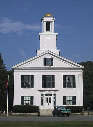
Orange County is a county located in the U.S. state of Vermont. As of the 2020 census, the population was 29,277. Its shire town is the town of Chelsea. Orange County was organized on February 2, 1781, as an original county within the state.

<span class="mw-page-title-main">Orford, New Hampshire</span> Town in New Hampshire, United States

Orford is a town in Grafton County, New Hampshire, United States. The population was 1,237 at the 2020 census, unchanged from the 2010 census. The Appalachian Trail crosses in the east.

<span class="mw-page-title-main">Woodsville, New Hampshire</span> Census-designated place in New Hampshire, United States

Woodsville is a census-designated place (CDP) and the largest village in the town of Haverhill in Grafton County, New Hampshire, United States, along the Connecticut River at the mouth of the Ammonoosuc River. The population was 1,431 at the 2020 census. Although North Haverhill is now the county seat of Grafton County, the village of Woodsville has traditionally been considered the county seat, as the county courthouse was originally located there. The county buildings are now located halfway between Woodsville and the village of North Haverhill to the south.

<span class="mw-page-title-main">Ryegate, Vermont</span> Town in Vermont, United States

Ryegate is a town in Caledonia County, Vermont, United States. The population was 1,165 at the 2020 census. The town contains the villages of South Ryegate, East Ryegate, and Ryegate Corner.

<span class="mw-page-title-main">Waterford, Vermont</span> Town in Vermont, United States

Waterford is a town in Caledonia County, Vermont, United States. The population was 1,268 at the 2020 census.

<span class="mw-page-title-main">Lunenburg, Vermont</span> Town in Vermont, United States

Lunenburg is a town in Essex County, Vermont, United States. The population was 1,246 at the 2020 census, the most populous in Essex County. Lunenburg contains the villages of Lunenburg and Gilman and hamlets of West Lunenburg, South Lunenburg, and Mill Village, and is part of the Berlin, NH –VT Micropolitan Statistical Area.

<span class="mw-page-title-main">Vershire, Vermont</span> Town in Vermont, United States

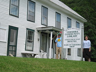
Vershire is a town in Orange County, Vermont, United States, created under Vermont Charter of August 3, 1781. The population was 672 at the 2020 census. The name Vershire is a portmanteau of Vermont and New Hampshire.

<span class="mw-page-title-main">Wells River, Vermont</span> Village in Vermont, United States

Wells River is a village in the town of Newbury in Orange County, Vermont, United States. The population was 431 at the 2020 census. The village center is located at the junction of U.S. Routes 5 and 302.

<span class="mw-page-title-main">West Fairlee, Vermont</span> Town in Vermont, United States

West Fairlee is a town in Orange County, Vermont, United States. The population was 621 at the 2020 census.

<span class="mw-page-title-main">Dummerston, Vermont</span> Town in Vermont, United States

Dummerston is a town in Windham County, Vermont, United States. The population was 1,865 at the 2020 census. It is home to the longest covered bridge still in use in Vermont. Its borders include three main villages: Dummerston Center, West Dummerston, and East Dummerston.

<span class="mw-page-title-main">Rockingham, Vermont</span> Town in Vermont, United States

Rockingham is a town along the Connecticut River in Windham County, Vermont, United States. As of the 2020 census, the population was 4,832. Rockingham includes the incorporated villages of Bellows Falls and Saxtons River, as well as a large rural area west of Interstate 91.

<span class="mw-page-title-main">Hartford, Vermont</span> Town in Vermont, United States

Hartford is a town in Windsor County, Vermont, United States. It is on the New Hampshire border, at the intersection of Interstates 89 and 91. It is the site of the confluence of the White and Connecticut rivers; the Ottauquechee River also flows through the town. The town is composed of five unincorporated villages: Hartford, Quechee, West Hartford, White River Junction and Wilder. As of the 2020 census, the population was 10,686.

<span class="mw-page-title-main">Sharon, Vermont</span> Town in Vermont, United States

Sharon is a town in Windsor County, Vermont, United States. It had a population of 1,560 at the 2020 census.

<span class="mw-page-title-main">White River Junction, Vermont</span> Census-designated place in Vermont, United States

White River Junction is an unincorporated village and census-designated place (CDP) in the town of Hartford in Windsor County, Vermont, United States. The population was 2,528 at the 2020 census, up from 2,286 in 2010, making it the largest community within the town of Hartford.

<span class="mw-page-title-main">Wilder, Vermont</span> Census-designated place in Vermont, United States

Wilder is an unincorporated village and census-designated place (CDP) within the town of Hartford in Windsor County, Vermont, United States. It is the location of the Wilder Dam on the Connecticut River. The population of the CDP was 1,690 at the 2010 census. The village center is an early example of a planned mill community, and was listed on the National Register of Historic Places as the Wilder Village Historic District in 1999.

<span class="mw-page-title-main">Windsor, Vermont</span> Town in Vermont, United States

Windsor is a town in Windsor County, Vermont, United States. As the "Birthplace of Vermont", the town is where the Constitution of Vermont was adopted in 1777, thus marking the founding of the Vermont Republic, a sovereign state until 1791, when Vermont joined the United States. Over much of its history, Windsor was home to a variety of manufacturing enterprises. Its population was 3,559 at the 2020 census.

<span class="mw-page-title-main">Newbury (town), Vermont</span> Town in Vermont, United States

Newbury is a town in Orange County, Vermont, United States. The population was 2,293 at the 2020 census. Newbury includes the villages of Newbury, Center Newbury, West Newbury, South Newbury, Boltonville, Peach Four Corners, and Wells River.

<span class="mw-page-title-main">Westminster (town), Vermont</span> Town in Vermont, United States

Westminster is a town in Windham County, Vermont, United States. The population was 3,016 at the 2020 census. It is also the first capital of the Republic of Vermont. It borders the state of New Hampshire.

<span class="mw-page-title-main">St. Johnsbury, Vermont</span> Town in Vermont, United States

St. Johnsbury is the shire town of Caledonia County, Vermont, United States. As of the 2020 census, the population was 7,364. St. Johnsbury is situated on the Passumpsic River and is located approximately six miles northwest of the Connecticut River and 48 miles (77 km) south of the Canada–U.S. border.

<span class="mw-page-title-main">Bradford, Vermont</span> Town in Vermont, United States

Bradford is a town in Orange County, Vermont, United States. The population was 2,790 at the 2020 census. Bradford is located on the county's eastern border, bordering both the Connecticut River and New Hampshire, and is a commercial center for some of its surrounding towns.

References

  1. "Town of Fairlee Vermont". Town of Fairlee Vermont. Retrieved October 22, 2012.
  2. 1 2 "U.S. Census website". United States Census Bureau . Retrieved January 31, 2008.
  3. U.S. Geological Survey Geographic Names Information System: Fairlee
  4. "Census - Geography Profile: Fairlee town, Orange County, Vermont" . Retrieved December 30, 2021.
  5. "Lake Morey Ice Skating Trail". Archived from the original on July 21, 2015. Retrieved July 10, 2012.
  6. 1 2 A. J. Coolidge & J. B. Mansfield, A History and Description of New England; Boston, Massachusetts 1859
  7. National Register of Historic Places -- Fairlee Railroad Depot
  8. "U.S. Decennial Census". United States Census Bureau. Retrieved May 16, 2015.
  9. "Rivendell Interstate SAU Office". New Hampshire Department of Education . Retrieved April 28, 2024.
  10. Smith, Nicola (December 4, 2023). "Rivendell board OKs plan that would close elementary school". Valley News . Retrieved April 28, 2024.
  11. Sally Denton, The Pink Lady: The Many Lives of Helen Gahagan Douglas, 2009, page 12
  12. Edward T. James, Janet Wilson James, Paul S. Boyer, Notable American Women: A Biographical Dictionary, Volume 5, 2004, page 178
  13. Smith, Win (June 16, 2010). "Myt Turn:Taxes put sustainability at risk". Burlington Free Press. Burlington, Vermont. pp. 6A.
  14. Vermont Historical Society, Proceedings of the Vermont Historical Society, 1915, page 203
  15. "MALLARY, Richard Walker, (1929 - 2011)". Biographical Directory of the United States Congress. Retrieved October 22, 2012.
  16. Ullery, Jacob G. (1894). Men of Vermont: An Illustrated Biographical History of Vermonters and Sons of Vermont. Brattleboro, VT: Transcript Publishing Company. p. 194 via Google Books.
  17. "MORRISON, George Washington, (1809 - 1888)". Biographical Directory of the United States Congress. Retrieved October 22, 2012.
  18. "Niles, Nathaniel (1741-1828)". The Political Graveyard. Retrieved October 22, 2012.
  19. "Stephen Thomas". Vermont in the Civil War. Retrieved October 22, 2012.