
Strasburg is an unincorporated town, a post office, and a census-designated place (CDP) located in and governed by Adams and Arapahoe counties, Colorado, United States. The CDP is a part of the Denver–Aurora–Lakewood, CO Metropolitan Statistical Area. The Strasburg post office has the ZIP Code 80136. At the United States Census 2010, the population of the Strasburg CDP was 2,447, while the population of the 80136 ZIP Code Tabulation Area was 4834 including adjacent communities.

Byers is an unincorporated town, a post office, and a census-designated place (CDP) located in and governed by Arapahoe County, Colorado, United States. The CDP is a part of the Denver–Aurora–Lakewood, CO Metropolitan Statistical Area. The Byers post office has the ZIP Code 80103. At the United States Census 2010, the population of the Byers CDP was 1,160, while the population of the 80103 ZIP Code Tabulation Area was 2,458 including adjacent areas.

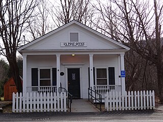
Sedalia is an unincorporated town, a post office, and a census-designated place (CDP) located in and governed by Douglas County, Colorado, United States. The CDP is a part of the Denver–Aurora–Lakewood, CO Metropolitan Statistical Area. The Sedalia post office has the ZIP Code 80135. At the United States Census 2010, the population of the Sedalia CDP was 206, while the population of the 80135 ZIP Code Tabulation Area was 3,833 including adjacent areas.

Lake George is an unincorporated community and census-designated place (CDP) in Lake George Township, Hubbard County, Minnesota, United States. As of the 2010 census, its population was 230.

Canaan is a census-designated place comprising the main settlement in the town of Canaan, Essex County, Vermont, United States. As of the 2010 census, it had a population of 392, out of a total town population of 972.

Maury is an unincorporated community and census-designated place (CDP) in Greene County, North Carolina, United States. Its population was 1,685 as of the 2010 census. Maury has a post office with ZIP code 28554. North Carolina Highway 123 and North Carolina Highway 903 intersect in the community.

South Mills is an unincorporated community and census-designated place (CDP) in Camden County, North Carolina, United States. Its population was 454 as of the 2010 census. South Mills has a post office with ZIP code 27976, which opened on March 2, 1840. The community is located near U.S. Route 17, and U.S. Route 17 Business and North Carolina Highway 343 pass through the community.

Hoyt is an unincorporated community and census-designated place (CDP) in Haskell County, Oklahoma, United States. The community is 3.9 miles (6.3 km) west-northwest of Whitefield. A post office was established at Hoyt, Indian Territory on August 19, 1890. It was named for Babe Hoyt, a local ferryboat operator. The post office closed on April 17, 2004; it still has its own ZIP code, 74440.
Gowen is an unincorporated community and census-designated place (CDP) in Latimer County, Oklahoma, United States. The community is located to the south of U.S. Route 270 and 10 miles (16 km) west-southwest of Wilburton. Gowen has a post office with ZIP code 74545. The post office at Gowen, Indian Territory opened on January 13, 1894. The community was named for lawyer Francis I. Gowen. At the time of its founding, Gowen was located in the Moshulatubbee District of the Choctaw Nation.

Pierrepont Manor is a hamlet and census-designated place (CDP) in Jefferson County, New York, United States. Its population was 228 as of the 2010 census. Pierrepont Manor has a post office with ZIP code 13674, which opened on November 29, 1843. U.S. Route 11 and New York State Route 193 intersect in the community; it is also served by an exit on Interstate 81.
Linwood is a hamlet and census-designated place (CDP) in the town of York, Livingston County, New York, United States. Its population was 74 as of the 2010 census. Linwood had a post office until February 6, 1993; it still has its own ZIP code, 14486.
Livonia Center is a hamlet and census-designated place (CDP) in the town of Livonia, Livingston County, New York, United States. Its population was 421 as of the 2010 census. Livonia Center has a post office with ZIP code 14488, which opened on April 9, 1811.
South Lima is a hamlet and census-designated place (CDP) in Livingston County, New York, United States. Its population was 240 as of the 2010 census. South Lima had a post office from January 10, 1854, until April 17, 2010; it still has its own ZIP code, 14558.

Hartland Four Corners is an unincorporated village in the town of Hartland, Windsor County, Vermont, United States. The community is located along Vermont Route 12, 8.8 miles (14.2 km) southwest of White River Junction. Hartland Four Corners has a post office with ZIP code 05049, which opened on July 5, 1854.

West Dummerston is an unincorporated village and census-designated place (CDP) in the town of Dummerston, Windham County, Vermont, United States. The community is located along Vermont Route 30 and the West River 6 miles (9.7 km) north-northwest of Brattleboro. West Dummerston has a post office with ZIP code 05357.
Underhill Center is an unincorporated village and census-designated place (CDP) in the town of Underhill, Chittenden County, Vermont, United States. The community is 4.9 miles (7.9 km) east of the village of Jericho. Underhill Center has a post office with ZIP code 05490, which opened on December 30, 1850.

North Hyde Park is an unincorporated village and census-designated place (CDP) in the towns of Hyde Park and Johnson, Lamoille County, Vermont, United States. The CDP was first drawn for the 2020 census. North Hyde Park has a post office with ZIP code 05665, which opened on May 29, 1839.
East Poultney is an unincorporated village and census-designated place (CDP) in the town of Poultney, Rutland County, Vermont, United States. The community is located along Vermont Route 140 1.7 miles (2.7 km) east-northeast of the village of Poultney.
Hydeville is an unincorporated village in the southwest part of the town of Castleton, Rutland County, Vermont, United States. The community is located along Vermont Route 4A 12.8 miles (20.6 km) west of Rutland. Hydeville has a post office with ZIP code 05750. As of the 2020 United States census, Hydeville is included in the Castleton Four Corners census-designated place for population statistics purposes.
Lyndon Center is an unincorporated village and census-designated place (CDP) in the town of Lyndon, Caledonia County, Vermont, United States. The community is located along the western border of Lyndonville. Lyndon Center has a post office with ZIP code 05850. The community was first listed as a CDP prior to the 2020 census.


