Lake Pocotopaug, Connecticut

Last updated

Lake Pocotopaug, Connecticut
Lake Pocotopaug.JPG
Lake Pocotopaug
USA Connecticut location map.svg
Red pog.svg
Lake Pocotopaug
Usa edcp location map.svg
Red pog.svg
Lake Pocotopaug
Coordinates: 41°35′54″N72°30′37″W / 41.59833°N 72.51028°W / 41.59833; -72.51028
Country Flag of the United States.svg  United States
State Connecticut
County Middlesex
Town East Hampton
Area
[1]
  Total16.30 km2 (6.293 sq mi)
  Land14.22 km2 (5.491 sq mi)
  Water2.08 km2 (0.802 sq mi)
Elevation
[2]
140 m (470 ft)
Population
 (2020) [3]
  Total4,901
  Density344.6/km2 (892.6/sq mi)
Time zone UTC-5 (Eastern (EST))
  Summer (DST) UTC-4 (EDT)
ZIP Code
06424 (East Hampton)
Area codes 860/959
FIPS code 09-41410
GNIS feature ID2377828 [2]

Lake Pocotopaug is an unincorporated village and census-designated place (CDP) in the town of East Hampton in Middlesex County, Connecticut, United States. As of the 2020 census, it had a population of 4,901, [3] up from 3,436 in 2010. [4]

Contents

It is named for the large local lake, which for years has been a popular resort area. The lake is surrounded by numerous homes. Most are year-round residences, although some summer cottages dot the shore. It is especially noted for two islands in its center, separated by a narrow, shallow strait (both of which have cabins).

The lake

Lake Pocotopaug, at 512 acres (207 ha), is large, but many other lakes in Connecticut are larger. The largest by far, is Candlewood Lake at 5,064 acres (2,049 ha). [5]

The lake's name reportedly comes from the local Wangunk Indian language for "Lake with Pierced Islands" or "Divided Pond". [6] According to local legend, some time long before the area was settled by whites, the tribe living there felt they were being cursed by their irritable Great Spirit. To try to appease him, the main chief agreed to sacrifice his daughter, who willingly threw herself into the lake and drowned. The tribe's shamans announced that never again would an Indian be killed on the lake.

The Wangunk were also said to have hunted on Spellman's Point, now a quaint street lined with cottages, using loud noises to scare the animals to the end of the peninsula, and thereby an effective way to gather food. However, in the mid-to-late 1800s it was sold for a sack of beans to the "Bay point" society.[ citation needed ]

Sears Park is located at the lake and has various swimming, boating and recreational facilities for residents.

In recent years the lake has become a place of ecological study due to the large-scale algae blooms that started appearing in 2000. Tests have shown that increasing watershed land development and fertilizer use are causing issues. A town-sanctioned Lake Commission and the Friends of Lake Pocotopaug are two organizations concentrating on improvement ideas.

In late spring and summer 2020, a rehabilitation project began, focusing on pumping fresh air into the lake bottom at multiple sites around the lake. These were added throughout the lake in a stepwise process. Additionally, a "bioblast" treatment with favorable bacterial organisms was completed in early August 2020. Within a single season, water clarity increased and has been steadily improving. This successful intervention has interrupted nearly two decades of regular summer algae blooms, with no significant bloom occurring in 2020. Dramatic improvement in the lake's water quality has resulted. How long term this improvement will be sustained remains to be seen. [ citation needed ]

The lake has scattered rock hazards, including one marked by a small memorial lighthouse in its southeast portion. "Claudia's Light - 2006" is identified on the base. Although its light is currently nonfunctional, the lighthouse has undergone a restoration and repainting by good samaritans.

Geography

Lake Pocotopaug is in northeastern Middlesex County, in the northern part of the town of East Hampton. The Lake Pocotopaug CDP covers the lake and includes the surrounding highlands. It is bordered to the south by the village of East Hampton and to the west by Meshomasic State Forest.

According to the United States Census Bureau, the Lake Pocotopaug CDP has a total area of 6.3 square miles (16 km2). 5.5 square miles (14 km2) of it are land and 0.8 square miles (2.1 km2) of it (12.74%) are water. [1] The lake drains to the south into the village of East Hampton and continues down Pocotopaug Creek and Pine Brook into the Salmon River, a tributary of the Connecticut River.

Demographics

As of the census [7] of 2000, there were 3,169 people, 1,347 households, and 844 families residing in the CDP. The population density was 456.6/km2 (1,183.9/mi2). There were 1,532 housing units at an average density of 220.7/km2 (572.3/mi2). The racial makeup of the CDP was 96.81% White, 0.95% African American, 0.35% Native American, 0.92% Asian, 0.03% Pacific Islander, 0.03% from other races, and 0.92% from two or more races. Hispanic or Latino of any race were 1.01% of the population.

There were 1,347 households, out of which 32.0% had children under the age of 18 living with them, 49.1% were married couples living together, 10.2% had a female householder with no husband present, and 37.3% were non-families. 29.0% of all households were made up of individuals, and 8.0% had someone living alone who was 65 years of age or older. The average household size was 2.35 and the average family size was 2.92.

In the CDP, the population was spread out, with 23.4% under the age of 18, 6.6% from 18 to 24, 35.1% from 25 to 44, 25.1% from 45 to 64, and 9.8% who were 65 years of age or older. The median age was 38 years. For every 100 females, there were 102.9 males. For every 100 females age 18 and over, there were 100.4 males.

The median income for a household in the CDP was $58,325, and the median income for a family was $71,667. Males had a median income of $51,440 versus $37,891 for females. The per capita income for the CDP was $28,317. About 3.2% of families and 5.1% of the population were below the poverty line, including 4.1% of those under age 18 and 11.8% of those age 65 or over.

Related Research Articles

<span class="mw-page-title-main">Conning Towers Nautilus Park, Connecticut</span> Census-designated place in Connecticut, United States

Conning Towers Nautilus Park is a census-designated place (CDP) in the town of Groton in New London County, Connecticut, United States. The population was 9,828 at the 2010 census. The statistical area consists of the portion of the town in the vicinity of Route 12 and includes Naval Submarine Base New London.

<span class="mw-page-title-main">Coventry Lake, Connecticut</span> Census-designated place in Connecticut, United States

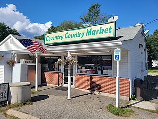
Coventry Lake is a village and census-designated place in the town of Coventry, Connecticut in Tolland County, Connecticut, United States. The population was 2,990 at the 2010 census. The CDP includes the residential areas around Wangumbaug Lake.

<span class="mw-page-title-main">Crystal Lake, Connecticut</span> Census-designated place in Connecticut, United States

Crystal Lake is a village, census-designated place, and part of the town of Ellington, in Tolland County, Connecticut, United States. The population was 1,945 at the 2010 census. The CDP includes an eponymous lake.

<span class="mw-page-title-main">South Coventry (CDP), Connecticut</span> CDP in Connecticut, United States

South Coventry is a census-designated place and part of the town of Coventry, Connecticut in Tolland County, Connecticut, United States. The population was 1,483 at the 2010 census.

<span class="mw-page-title-main">East Brooklyn, Connecticut</span> Census-designated place in Connecticut, United States

East Brooklyn is a census-designated place (CDP) located within the town of Brooklyn in Windham County, Connecticut. It is the portion of the Danielson urban cluster within the town of Brooklyn. The population was 2,205 at the 2020 census. US 6 runs through the town and severs the town.

<span class="mw-page-title-main">Quinebaug, Connecticut</span> Census-designated place in Connecticut, United States

Quinebaug is a village and census-designated place (CDP) in Thompson, a town in Windham County, Connecticut, United States. The population was 1,133 at the 2010 census.

<span class="mw-page-title-main">South Windham, Connecticut</span> Village in Connecticut, United States

South Windham is a village and census-designated place (CDP) in Windham County, Connecticut, United States. It is located within the town of Windham, Connecticut. The population was 1,421 at the 2010 census.

<span class="mw-page-title-main">Lake Hart, Florida</span> Census-designated place in Florida, United States

Lake Hart is a census-designated place and an unincorporated area in Orange County, Florida, United States. The population was 542 as of the 2010 census. It is part of the Orlando–Kissimmee Metropolitan Statistical Area.

<span class="mw-page-title-main">Sky Lake, Florida</span> Census-designated place in Florida, United States

Sky Lake is a census-designated place (CDP) and an unincorporated area in Orange County, Florida, United States. The population was 6,153 at the 2010 census. It is part of the Orlando-Kissimmee, Florida Metropolitan Statistical Area.

<span class="mw-page-title-main">Hamptons at Boca Raton, Florida</span> Unincorporated place in Florida, United States

Hamptons at Boca Raton was a former census-designated place (CDP) and current unincorporated place near Boca Raton in Palm Beach County, Florida, United States. The population was 11,306 at the 2000 census. While it is not officially in the City of Boca Raton, the community is frequently classified under its umbrella term.

<span class="mw-page-title-main">Crooked Lake Park, Florida</span> Census-designated place in Florida, United States

Crooked Lake Park is a census-designated place (CDP) in Polk County, Florida, United States. The population was 1,682 at the 2000 census. It is part of the Lakeland–Winter Haven Metropolitan Statistical Area.

<span class="mw-page-title-main">East Douglas, Massachusetts</span> CDP in Massachusetts, United States

East Douglas is a census-designated place (CDP) in the town of Douglas in Worcester County, Massachusetts, United States. The population was 2,557 at the 2010 census.

<span class="mw-page-title-main">Fiskdale, Massachusetts</span> CDP in Sturbridge, Massachusetts, United States

Fiskdale is a census-designated place (CDP) in the town of Sturbridge in Worcester County, Massachusetts, United States. The population was 2,583 at the 2010 census.

<span class="mw-page-title-main">Crystal Lake, Polk County, Florida</span> Census-designated place in Florida, United States

Crystal Lake is a census-designated place (CDP) in Polk County, Florida, United States. The population was 5,341 at the 2000 census, an increase from 5,300 in 1990. The 2010 Census reported a population of 5,514. It is part of the Lakeland–Winter Haven Metropolitan Statistical Area.

<span class="mw-page-title-main">Crandon Lakes, New Jersey</span> Populated place in Sussex County, New Jersey, US

Crandon Lakes is an unincorporated community and census-designated place (CDP) split between Hampton Township and Stillwater Township, in Sussex County, in the U.S. state of New Jersey. As of the 2010 United States Census, the CDP's population was 1,178, of which 682 were in Hampton Township and 496 in Stillwater Township.

<span class="mw-page-title-main">East Hampton North, New York</span> Census-designated place in New York, United States

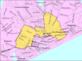
East Hampton North is a census-designated place (CDP) in Suffolk County, New York, United States. At the 2010 census, the population was 4,142.

<span class="mw-page-title-main">Wilder, Vermont</span> Census-designated place in Vermont, United States

Wilder is an unincorporated village and census-designated place (CDP) within the town of Hartford in Windsor County, Vermont, United States. It is the location of the Wilder Dam on the Connecticut River. The population of the CDP was 1,690 at the 2010 census. The village center is an early example of a planned mill community, and was listed on the National Register of Historic Places as the Wilder Village Historic District in 1999.

<span class="mw-page-title-main">Ayer (CDP), Massachusetts</span> Census-designated place in Massachusetts, United States

Ayer is a census-designated place (CDP) and the primary settlement in the town of Ayer in Middlesex County, Massachusetts, United States. The population of the CDP was 2,986 at the 2020 census, out of 8,479 in the entire town.

<span class="mw-page-title-main">Brattleboro (CDP), Vermont</span> CDP in Vermont, United States

Brattleboro is a census-designated place (CDP) corresponding to the densely populated core of the town of Brattleboro in Windham County, Vermont, United States. The population was 8,289 at the 2000 census.

<span class="mw-page-title-main">Townsend (CDP), Massachusetts</span> Census-designated place in Massachusetts, United States

Townsend is a census-designated place (CDP) comprising the main village in the town of Townsend in Middlesex County, Massachusetts, United States. The population was 1,213 at the 2020 census, out of 9,127 in the entire town.

References

  1. 1 2 "2022 U.S. Gazetteer Files: Connecticut". United States Census Bureau. Retrieved December 12, 2022.
  2. 1 2 "Lake Pocotopaug Census Designated Place". Geographic Names Information System . United States Geological Survey, United States Department of the Interior.
  3. 1 2 "P1. Race – Lake Pocotopaug CDP, Connecticut: 2020 DEC Redistricting Data (PL 94-171)". U.S. Census Bureau. Retrieved December 12, 2022.
  4. "P1. Race – Pocotopaug CDP, Connecticut: 2010 DEC Redistricting Data (PL 94-171)". U.S. Census Bureau. Retrieved December 12, 2022.
  5. "Connecticut Lakes…Sizes and Information". ctwaterfrontlife.com. Archived from the original on May 5, 2012.
  6. Price, Carl F. "Yankee Township". East Hampton, Conn.: Citizens' Welfare Club, 1941. 9.
  7. "U.S. Census website". United States Census Bureau . Retrieved January 31, 2008.