Windsor County is a county located in the U.S. state of Vermont. As of the 2020 census, the population was 57,753. The shire town is the town of Woodstock. The county's largest municipality is the town of Hartford.

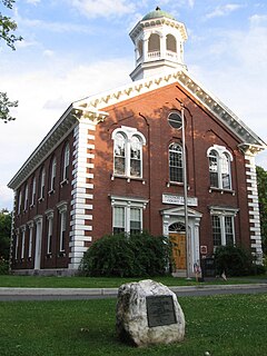
Perkinsville was a village located in the town of Weathersfield, Windsor County, Vermont, United States. The population was 108 at the 2020 census.

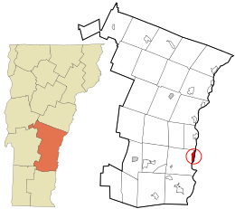
Weathersfield is a town in Windsor County, Vermont, United States. The population was 2,842 at the 2020 census.

West Windsor is a town in Windsor County, Vermont, United States. The population was 1,344 at the 2020 census. It was known for its Ascutney Mountain Resort, which closed in 2010 and was bought by its citizens in 2015.

Windsor is a town in Windsor County, Vermont, United States. As the "Birthplace of Vermont", the town is where the Constitution of Vermont was adopted in 1777, thus marking the founding of the Vermont Republic, a sovereign state until 1791, when Vermont joined the United States. Over much of its history, Windsor was home to a variety of manufacturing enterprises. Its population was 3,559 at the 2020 census.

Ludlow is a town in Windsor County, Vermont, United States. The population was 2,172 at the 2020 census. Ludlow is the home of Okemo Mountain, a popular ski resort. Before becoming a ski destination, Ludlow was originally a mill town, and was the home of a General Electric plant until 1977. It was named after Ludlow, Massachusetts which is less than 100 miles away. There is also a village of Ludlow in the town.
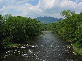
Mount Ascutney is a mountain in the U.S. state of Vermont. At 3,144 feet (958 m), it is the second-highest peak in Windsor County. Mount Ascutney is a monadnock that rises abruptly from the surrounding lowlands. For example, the Windsor Trail is 2.7 miles (4.3 km) to the summit with 2,514 feet (766 m) of elevation gain and an overall 18% grade. Particularly noteworthy are the mountain's granite outcrops, one of which, near the summit, serves as a launching point for hang-gliders.

Quechee is a census-designated place and one of five unincorporated villages in the town of Hartford, Windsor County, Vermont, United States. As of the 2010 census, the population of the CDP was 656. It is the site of Quechee Gorge on the Ottauquechee River and is also the home to the Quechee Lakes planned community, initiated in the late 1960s, which also brought to the community the small Quechee Lakes Ski Area in the 1970s.

South Royalton is an unincorporated village and census-designated place (CDP) in the town of Royalton, Windsor County, Vermont, United States. With a population at the 2010 census of 694, South Royalton is the largest community in the town. It is home to the Vermont Law School. The central portion of the village is a historic district, listed on the National Register of Historic Places as the South Royalton Historic District. The Joseph Smith Birthplace Memorial is located approximately two miles to the east. South Royalton is the town pictured in the opening credits of the WB television show Gilmore Girls.

North Springfield is an unincorporated community and census-designated place in the town of Springfield, Windsor County, Vermont, United States. As of the 2010 census, the population of the CDP was 573. It lies at an altitude of 495 feet (151 m). A post office has been operated in North Springfield since 1832. Black River Produce, a major food processor and distributor, is headquartered in the village.

Vermont Route 44 (VT 44) is a state highway in the U.S. state of Vermont. The highway runs 10.190 miles (16.399 km) from VT 106 in Reading east to U.S. Route 5 (US 5) and VT 12 in Windsor. VT 44 passes through West Windsor in southern Windsor County, serving the area north of Mount Ascutney. The highway has an auxiliary route, VT 44A, which provides access to Mount Ascutney State Park and connects VT 44 with Interstate 91 (I-91) in Weathersfield. VT 44 was established in 1958 along the highway between Reading and Windsor. The three towns had previously maintained the highway with support from the state for construction and maintenance, including reconstruction along several segments in the 1940s. The state paved VT 44 in the early 1970s and early 1980s. VT 44A was established in 1987 when part of VT 44 in Windsor was returned to town maintenance.

South Woodstock is an unincorporated village and census-designated place (CDP) in the town of Woodstock in Windsor County, Vermont, United States. Its elevation is 1,040 feet (320 m), and it is located at 43°33′56″N72°31′56″W, in the Kedron Valley.

North Hartland is a census-designated place (CDP) in the town of Hartland, Windsor County, Vermont, United States. As of the 2010 census, the population of the CDP was 302.

Proctorsville is a census-designated place (CDP) in the town of Cavendish, Windsor County, Vermont, United States. As of the 2010 census, the population of the CDP was 454.

Bethel is a census-designated place (CDP) that comprises the central village of the town of Bethel, Windsor County, Vermont, United States. As of the 2010 census, the population of the CDP was 569, compared to 2,030 for the entire town of Bethel.

Cavendish is a census-designated place, the central village of the town of Cavendish, Windsor County, Vermont, United States. Until the mid–nineteenth century it was known as Duttonsville. As of the 2010 census, the population of the CDP was 179, compared to 1,367 for the entire town of Cavendish.

Hartland is a census-designated place (CDP) that comprises the central village of the town of Hartland, Windsor County, Vermont, United States. As of the 2010 census, the population of the CDP was 380, compared to 3,393 for the entire town of Hartland.

Norwich is a census-designated place (CDP) that comprises the central village of the town of Norwich, Windsor County, Vermont, United States. As of the 2010 census, the population of the CDP was 878, compared to 3,414 for the entire town of Norwich.

Rochester is a census-designated place (CDP) that comprises the central village of the town of Rochester, Windsor County, Vermont, United States. As of the 2010 census, the population of the CDP was 299, compared to 1,139 for the entire town of Rochester.

Windsor is a census-designated place (CDP) comprising the main settlement within the town of Windsor, Windsor County, Vermont, United States. The population of the CDP was 2,066 at the 2010 census, compared with 3,553 for the town as a whole.