
The Delaware Memorial Bridge is a dual-span suspension bridge crossing the Delaware River. The toll bridges carry Interstate 295 and U.S. Route 40 and is also the link between Delaware and New Jersey. The bridge was designed by the firm of Howard, Needles, Tammen & Bergendoff with consulting help from engineer Othmar Ammann, whose other designs include the George Washington Bridge and the Verrazzano-Narrows Bridge.

The Commodore Barry Bridge is a cantilever bridge that spans the Delaware River from Chester, Pennsylvania to Bridgeport, New Jersey, in Logan Township. It is named after John Barry, an American Revolutionary War hero and Philadelphia resident.
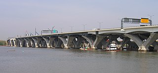
The Woodrow Wilson Memorial Bridge, also known as the Woodrow Wilson Bridge or the Wilson Bridge, is a bascule bridge that spans the Potomac River between Alexandria, Virginia and Oxon Hill, Maryland in Prince George's County, Maryland. The original bridge was one of only a handful of drawbridges in the Interstate Highway System. It contained the only portion of the Interstate System owned and operated by the federal government until construction was completed and it was turned over to the Virginia and Maryland departments of transportation.
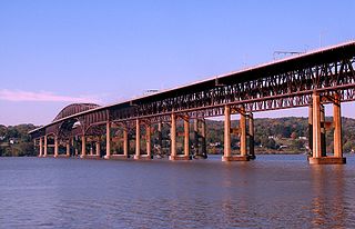
The Newburgh–Beacon Bridge is a continuous truss toll bridge that spans the Hudson River in New York State. The bridge carries Interstate 84 (I-84) and New York State Route 52 (NY 52) between Newburgh and Beacon and consists of two separate spans. The original northern span, which now carries westbound traffic, was opened on November 2, 1963, as a two-lane bridge. A second span, completed in 1980, now carries all eastbound traffic. The span provides connections to the New York State Thruway (I-87) and U.S. Route 9W (US 9W) in Newburgh and US 9 in Fishkill. The bridges includes a 2,204-foot-long (672 m) cantilever span, with a main span of 1,000 feet (300 m) and side spans of 602 feet (183 m). The total length of all spans and approaches is 7,855 feet (2,394 m) for the north span and 7,789 feet (2,374 m) for the south span. The bridges, owned by the New York State Bridge Authority, carry six lanes of traffic and approximately 65,000 vehicles per day. The bridge is officially known as the Hamilton Fish Newburgh–Beacon Bridge.

The Carquinez Bridge is a pair of parallel bridges spanning the Carquinez Strait at the northeastern end of San Francisco Bay. They form the part of Interstate 80 between Crockett and Vallejo, California, United States.
The Connecticut Turnpike is a freeway and former toll road in the U.S. state of Connecticut; it is maintained by the Connecticut Department of Transportation (ConnDOT). Spanning approximately 128 miles (206 km) along a generally west–east axis, its roadbed is shared with Interstate 95 (I-95) for 88 miles (142 km) from the New York state border in Greenwich to East Lyme; I-395 for 36 miles (58 km) from East Lyme to Plainfield; and SR 695 for four miles (6.4 km) from Plainfield to the Rhode Island state line at U.S. Route 6 (US 6) in Killingly. The turnpike briefly runs concurrently with US 1 from Old Saybrook to Old Lyme and Route 2A from Montville to Norwich.

The Crescent City Connection (CCC), formerly the Greater New Orleans (GNO) Bridge, is a pair of cantilever bridges that carry U.S. Highway 90 Business over the Mississippi River in New Orleans, Louisiana, United States. They are tied as the fifth-longest cantilever bridges in the world. Each span carries four general-use automobile lanes; additionally the westbound span has two reversible HOV lanes across the river.

The Alexander Hamilton Bridge is an eight-lane steel arch bridge that carries traffic over the Harlem River between the boroughs of Manhattan and the Bronx in New York City. The bridge connects the Trans-Manhattan Expressway in the Washington Heights section of Manhattan with the Cross Bronx Expressway as part of Interstate 95 and U.S. 1.

The Bulkeley Bridge is the oldest of three highway bridges over the Connecticut River between Hartford, Connecticut and East Hartford, Connecticut. A stone arch bridge composed of nine spans, the bridge carries Interstate 84, U.S. Route 6, and U.S. Route 44 across the river. As of 2005, the bridge carried an average daily traffic of 142,500 cars. The arches are mounted on stone piers, and vary in length from 68 feet (21 m) to 119 feet (36 m); the total length of the bridge is 1,192 feet (363 m).

Interstate 95 (I-95) is the main north–south Interstate Highway on the East Coast of the United States, running in a general east–west compass direction for 111.57 miles (179.55 km) in Connecticut, from the New York state line to the Rhode Island state line. I-95 from Greenwich to East Lyme is part of the Connecticut Turnpike, during which it passes through the major cities of Stamford, Bridgeport, and New Haven. After leaving the turnpike in East Lyme, I-95 is known as the Jewish War Veterans Memorial Highway and passes through New London, Groton, and Mystic, before exiting the state through North Stonington at the Rhode Island border.

An extradosed bridge employs a structure that combines the main elements of both a prestressed box girder bridge and a cable-stayed bridge. The name comes from the word extrados, the exterior or upper curve of an arch, and refers to how the "stay cables" on an extradosed bridge are not considered as such in the design, but are instead treated as external prestressing tendons deviating upward from the deck. In this concept, they remain part of the main bridge superstructure.

The Delaware River–Turnpike Toll Bridge is a four-lane, steel through arch bridge crossing the Delaware River between Burlington Township, Burlington County, New Jersey and Bristol Township, Bucks County, Pennsylvania. As a part of Interstate 95 (I-95), it is a major highway link between Philadelphia and New York City. The bridge also connects the Pennsylvania Turnpike's east-west mainline with the main trunk of the New Jersey Turnpike, via the Pearl Harbor Memorial Turnpike Extension. Tolls are collected only in the west/southbound direction via electronic toll collection.
The Gold Star Memorial Bridge is a pair of steel truss bridges that carry both Interstate 95 and U.S. Route 1 across the Thames River between New London, Connecticut and Groton, Connecticut. The bridge is the largest structure in the state, with more than 1,000,000 sq ft (93,000 m2) of deck area, and the longest bridge in the state at 6,000 feet (1,829 m). Its 11 highway lanes accommodate an average daily traffic of 117,000 vehicles. The bridge is actually a set of twin bridges, but they are generally spoken of using the singular "bridge".

The Varodd Bridges are two parallel cantilever bridges in Kristiansand municipality, in Agder county, Norway, and they cross the Topdalsfjorden. They are named after the peninsula on the western shore. It goes from Vige and ends in Søm in Kristiansand. The bridges carry the European route E18 highway over the fjord.

Interstate 64 (I-64) is an Interstate Highway in the US state of West Virginia. It travels east–west through the state for 189 miles (304 km) passing by the major towns and cities of Huntington, Charleston, Beckley, and Lewisburg.

The Pearl Harbor Memorial Bridge, commonly referred to as the Q Bridge by locals, is an extradosed bridge that carries Interstate 95 over the mouth of the Quinnipiac River in New Haven, in the U.S. state of Connecticut. This bridge replaced the original 1,300 m (0.8 mi) span which opened on January 2, 1958. The old bridge had a girder and floorbeam design where steel beams supported a concrete bridge deck that carried three lanes of traffic in each direction with no inside or outside shoulders. The bridge was officially dedicated as the Pearl Harbor Memorial Bridge in 1995 to commemorate the attack on Pearl Harbor.

The East Haddam Swing Bridge is a steel, movable (swing) truss bridge. The bridge is composed of three spans crossing the Connecticut River between Haddam, Connecticut and East Haddam, Connecticut. The bridge carries Route 82, with an average daily traffic of 11,600. At the time of its construction, it was reputed to be the longest swing bridge of its kind in the world.

U.S. Route 1 (US 1) in the U.S. state of Connecticut is a major east–west U.S. Route along Long Island Sound. It has been replaced by Interstate 95 (I-95) as a through route, which it closely parallels, and now primarily serves as a local business route. Despite its largely east–west orientation, it is part of a north–south route and is mostly signed north–south.

The Washington Bridge, also known as the Devon Bridge, carries U.S. Route 1 (US 1) over the Housatonic River in the U.S. state of Connecticut, connecting the city of Milford to the town of Stratford. Its geographic location is N 41.20037 by W −73.11039. It is considered architecturally notable by the National Register of Historic Places for its five 100-foot-long (30 m) arches. It is designated Bridge No. 327 by the state Department of Transportation.

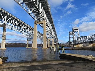
The Amtrak Old Saybrook–Old Lyme Bridge is the last crossing of the Connecticut River before it reaches Long Island Sound. It is a Truss bridge with a bascule span, allowing boat traffic to pass through. The bridge is owned by Amtrak and used by Northeast Regional, Acela Express, Shore Line East and a few freight trains traversing the Northeast Corridor. It can be seen from the Raymond E. Baldwin Bridge, as well as from various points on Route 154.


