
Westfield is a city in Hampden County, in the Pioneer Valley of western Massachusetts, United States. Westfield was first settled by Europeans in 1660. It is part of the Springfield, Massachusetts Metropolitan Statistical Area. The population was 40,834 at the 2020 census.

The Penobscot River is a 109-mile-long (175 km) river in the U.S. state of Maine. Including the river's West Branch and South Branch increases the Penobscot's length to 264 miles (425 km), making it the second-longest river system in Maine and the longest entirely in the state. Its drainage basin contains 8,610 square miles (22,300 km2).

The Hiwassee River originates from a spring on the north slope of Rocky Mountain in Towns County in the northern area of the State of Georgia. It flows northward into North Carolina before turning westward into Tennessee, flowing into the Tennessee River a few miles west of what is now State Route 58 in Meigs County, Tennessee. The river is about 147 miles (237 km) long.


The Farmington River is a river, 46.7 miles (75.2 km) in length along its main stem, located in northwest Connecticut with major tributaries extending into southwest Massachusetts. The longest route of the river, from the origin of its West Branch, is 80.4 miles (129.4 km) long, making it the Connecticut River's longest tributary by 2.3 miles (3.7 km) over the major river directly to its north, the Westfield River. The Farmington River's watershed covers 609 square miles (1,580 km2). Historically, the river played an important role in small-scale manufacturing in towns along its course, but it is now mainly used for recreation and drinking water.

Deerfield River is a river that runs for 76 miles (122 km) from southern Vermont through northwestern Massachusetts to the Connecticut River. The Deerfield River was historically influential in the settlement of western Franklin County, Massachusetts, and its namesake town. It is the Connecticut River's second-longest tributary in Massachusetts, 2.1 miles (3.4 km) shorter than Metropolitan Springfield's Westfield River.
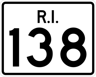
Route 138 is a numbered State Highway running 48.3 miles (77.7 km) in Rhode Island. It is the longest state numbered route in Rhode Island, and the second longest highway after US 1. Route 138 begins in Exeter at the Connecticut state line in the west and runs to the Massachusetts state line in Tiverton in the east, and is the only state-numbered route to completely cross Rhode Island. Route 138 also keeps the same route number on the other side of both state lines.
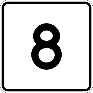
Route 8 is the portion of the 148 mile multistate New England Route 8 within the state of Massachusetts. The highway runs 66.643 miles (107.252 km) from the Connecticut state line in Sandisfield, where the highway continues as Connecticut Route 8, north to the Vermont state line in Clarksburg, where the highway continues as Vermont Route 8 and VT 100. Route 8 serves several towns in eastern and northern Berkshire County. The highway is the main highway between the cities of Pittsfield and North Adams, where the route intersects Route 9 and Route 2, respectively. Route 8 also intersects U.S. Route 20 in Becket.

The Contoocook River is a 71-mile-long (114 km) river in New Hampshire. It flows from Contoocook Lake on the Jaffrey/Rindge border to Penacook, where it empties into the Merrimack River. It is one of only a few rivers in New Hampshire that flow in a predominantly northward direction. Four covered bridges span the river, one in the town of Henniker, one on the Hancock-Greenfield line, and two in the town of Hopkinton, New Hampshire with one being in the village of Contoocook, and the other in the populated place of West Hopkinton. Residents and tourists have made the Contoocook popular for fishing and whitewater boating.
The Blackwater River is a 37.5-mile-long (60.4 km) river located in central New Hampshire in the United States. It is a tributary of the Contoocook River, part of the Merrimack River watershed.
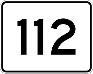
Route 112 is a 54.11-mile-long (87.08 km) rural state highway through western Franklin and Hampshire Counties. It begins at U.S. Route 20 in Huntington and ends at the Vermont state line in Colrain, where it continues as Vermont Route 112.

The Dead River, sometimes called the West Branch, is a 42.6-mile-long (68.6 km) river in central Maine in the United States. Its source is Flagstaff Lake, where its two main tributaries, South Branch Dead River and North Branch Dead River, join. It flows generally east to join the Kennebec River at The Forks, Maine.
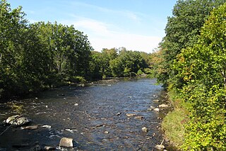
The Westfield River is a major tributary of the Connecticut River located in the Berkshires and Pioneer Valley regions of western Massachusetts. With four major tributary branches that converge west of the city of Westfield, it flows 78.1 miles (125.7 km) before its confluence with the Connecticut River at Agawam, across from the city of Springfield's Metro Center district. Known for its whitewater rapids and scenic beauty, the Westfield River provides over 50 miles (80 km) of whitewater canoeing and kayaking, in addition to one of the largest roadless wilderness areas remaining in the Commonwealth.
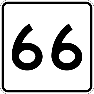
Route 66 is a state highway in the U.S. state of Massachusetts. The highway runs 13.65 miles (21.97 km) from Route 112 in Huntington east to Route 9 in Northampton. Route 66 connects the western Hampshire County towns of Huntington, Westhampton, and Northampton and passes through Smith College at its eastern end.

The Mill River is a river in the U.S. states of Massachusetts and Rhode Island. It flows approximately 17.1 miles (27.5 km).

Apremont is a commune in the department of Ardennes in the Grand Est region of northern France.
The Mount Hope River is a river in northeastern section of the U.S. state of Connecticut. The river is formed at the outlet of Morey Pond at the extreme northern end of Ashford, Connecticut, at the border of Union, Connecticut, and flows about 15 miles (24 km) south to Mansfield Hollow Lake, just south of Mansfield, Connecticut.

Route 187 is a 27.23-mile-long (43.82 km) secondary state route in the U.S. states of Connecticut and Massachusetts. It begins in the city of Hartford at Albany Avenue, travels north through the towns of Bloomfield, Windsor, East Granby and Suffield until the Connecticut-Massachusetts state line. Route 187 continues north across the state line through Agawam into Westfield, where the route ends at US 20 east of Westfield center. Route 187 crosses the Farmington River between the towns of Bloomfield and East Granby.

Route 143 is a state highway in the U.S. state of Massachusetts. The highway runs 24.490 miles (39.413 km) from Route 8 in Hinsdale east to Route 9 in Williamsburg. Route 143 passes through central Berkshire County town of Peru and the western Hampshire County towns of Worthington and Chesterfield.
