
The Leonard P. ZakimBunker Hill Memorial Bridge is a cable-stayed bridge completed in 2003 across the Charles River in Boston, Massachusetts. It is a replacement for the Charlestown High Bridge, an older truss bridge constructed in the 1950s.

The Harvard Bridge is a steel haunched girder bridge carrying Massachusetts Avenue over the Charles River and connecting Back Bay, Boston with Cambridge, Massachusetts. It is the longest bridge over the Charles River at 2,164.8 feet.
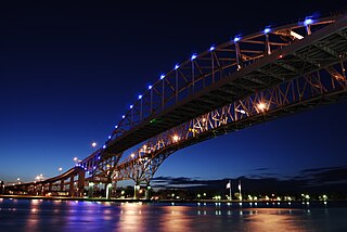
The Blue Water Bridge is a twin-span international bridge across the St. Clair River that links Port Huron, Michigan, United States, and Sarnia, Ontario, Canada. The Blue Water Bridge connects Highway 402 in Ontario with both Interstate 69 (I-69) and Interstate 94 (I-94) in Michigan.
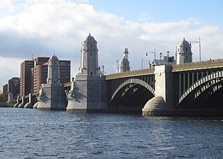
The Longfellow Bridge is a steel rib arch bridge spanning the Charles River to connect Boston's Beacon Hill neighborhood with the Kendall Square area of Cambridge, Massachusetts. The bridge carries Massachusetts Route 3, US Route 3, the MBTA Red Line, bicycle, and pedestrian traffic. The structure was originally known as the Cambridge Bridge, and a predecessor structure was known as the West Boston Bridge; Boston also continued to use "West Boston Bridge" officially for the new bridge. The bridge is also known to locals as the "Salt-and-Pepper Bridge" due to the shape of its central towers.

A truss bridge is a bridge whose load-bearing superstructure is composed of a truss, a structure of connected elements, usually forming triangular units. The connected elements may be stressed from tension, compression, or sometimes both in response to dynamic loads. The basic types of truss bridges shown in this article have simple designs which could be easily analyzed by 19th and early 20th-century engineers. A truss bridge is economical to construct because it uses materials efficiently.

The Astoria–Megler Bridge is a steel cantilever through truss bridge in the northwest United States that spans the lower Columbia River, between Astoria, Oregon, and Point Ellice near Megler, Washington. Opened 56 years ago, in 1966, it is the longest continuous truss bridge in North America.

Route 2 is a 142.29-mile-long (228.99 km) major east–west state highway in Massachusetts. Along with Route 9 and U.S. Route 20 to the south, these highways are the main alternatives to the Massachusetts Turnpike/I-90 toll highway. Route 2 runs the entire length of the northern tier of Massachusetts, beginning at the New York border, where it connects with New York State Route 2, and ending near Boston Common in Boston. Most of the route is a freeway through the northern tier of Massachusetts, with the longest non-limited access segments being the western portion. Older alignments of Route 2 are known as Route 2A.

The Boston University Bridge, originally the Cottage Farm Bridge and commonly referred to as the BU Bridge, is a steel truss through arch bridge with a suspended deck carrying Route 2 over the Charles River, connecting the Boston University campus to Cambridge, Massachusetts.

The Huey P. Long Bridge, located in Jefferson Parish, Louisiana, is a cantilevered steel through-truss bridge that carries a two-track railroad line over the Mississippi River at mile 106.1, with three lanes of US 90 on each side of the central tracks. It is several kilometers upriver from the city of New Orleans. The East Bank entrance is at Elmwood, Louisiana, and the West Bank at Bridge City.

The Arrigoni Bridge, also known locally as the Portland Bridge is a steel through arch bridge carrying Route 66 and Route 17 across the Connecticut River, connecting Middletown, Connecticut to Portland, Connecticut. When it opened in 1938, the 1,200 feet (370 m) bridge was the most expensive bridge ever built in Connecticut, at a cost of $3.5 million. Its two distinctive 600 feet (180 m) steel arches have the longest span length of any bridge in the state. The bridge has an average daily traffic of 33,600.
The Girard Point Bridge is a double-decked cantilevered truss bridge carrying Interstate 95 across the Schuylkill River in the American city of Philadelphia, Pennsylvania. The bridge was opened in 1973. It is the last crossing of the Schuylkill River, which empties into the Delaware River less than half a mile downstream. It has an has an average of 148,500 vehicles per day, including 6% truck traffic.

The Lamar Boulevard Bridge is a historic arch bridge carrying Texas State Highway Loop 343 over Lady Bird Lake in downtown Austin, Texas, United States. The bridge features six open-spandrel concrete arches spanning 659 feet (201 m) and carries tens of thousands of vehicles daily across the lake. Completed in 1942, the Lamar Boulevard Bridge was the second permanent bridge to cross the Colorado River, and one of the last Art Deco-style open-spandrel concrete arch bridges built in Texas. The bridge was named an Austin Landmark in 1993 and added to the National Register of Historic Places in 1994.

The East Haddam Swing Bridge is a steel, movable (swing) truss bridge. The bridge is composed of three spans crossing the Connecticut River between Haddam, Connecticut and East Haddam, Connecticut. The bridge carries Route 82, with an average daily traffic of 11,600. At the time of its construction, it was reputed to be the longest swing bridge of its kind in the world.

The Norwottuck Rail Trail Bridge is a former crossing of Boston and Maine Railroad over the Connecticut River in western Massachusetts, connecting the towns of Northampton and Hadley, by the Norwottuck Rail Trail, which is currently used for bicycle and foot traffic.

The Hampden County Memorial Bridge is a reinforced-concrete arch bridge that spans the Connecticut River between Springfield, Massachusetts and West Springfield, Massachusetts, constructed in 1922. The bridge is owned by Massachusetts Highway Department and is located on Massachusetts Route 147. It spans 209 feet (64 m) and rises 29.71 feet (9.06 m) above the river.

The Schell Memorial Bridge is a steel cantilever Pennsylvania (Petit) truss bridge spanning the Connecticut River in the town of Northfield, Massachusetts. Designed by Edward S. Shaw, the bridge abutments and piers were built by the firm of Ellis & Buswell of Woburn, Massachusetts, and the superstructure was built by the New England Structural Company of East Everett, Massachusetts. The bridge was commissioned by Francis R. Schell, who gave $42,000 for design and construction. Construction began in 1901 and was completed in 1903. In 1985, due to advanced deterioration of the steel truss members, the bridge was barricaded and abandoned.

The Washington Bridge, also known as the Devon Bridge, carries U.S. Route 1 (US 1) over the Housatonic River in the U.S. state of Connecticut, connecting the city of Milford to the town of Stratford. Its geographic location is N 41.20037 by W −73.11039. It is considered architecturally notable by the National Register of Historic Places for its five 100-foot-long (30 m) arches. It is designated Bridge No. 327 by the state Department of Transportation.

The Bellows Falls Arch Bridge was a three-hinged steel through arch bridge over the Connecticut River between Bellows Falls, Vermont and North Walpole, New Hampshire. It was structurally significant as the longest arch bridge in the United States when it was completed in 1905.

The Contoocook Railroad Bridge is a covered bridge on the former Contoocook Valley Railroad line spanning the Contoocook River in the center of the village of Contoocook, New Hampshire, United States. It is referred to in the National Register of Historic Places as the Hopkinton Railroad Covered Bridge, for the town of Hopkinton, New Hampshire, in which the village of Contoocook is located.

The Chelsea Street Bridge is a vertical-lift bridge that carries Chelsea Street between East Boston, Massachusetts, and Chelsea, Massachusetts, over the Chelsea Creek. It opened to traffic on May 12, 2012, after a $125.3M construction project replaced the previous bridge, a single-leaf bascule-type drawbridge. The span is 450 feet (140 m) with a vertical clearance, when opened, of 175 feet (53 m). There are two lanes and a sidewalk in each direction.


