The Connecticut River is the longest river in the New England region of the United States, flowing roughly southward for 406 miles (653 km) through four states. It rises 300 yards south of the U.S. border with Quebec, Canada, and discharges at Long Island Sound. Its watershed encompasses 11,260 square miles (29,200 km2), covering parts of five U.S. states and one Canadian province, via 148 tributaries, 38 of which are major rivers. It produces 70% of Long Island Sound's fresh water, discharging at 18,400 cubic feet (520 m3) per second.
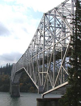
The Bridge of the Gods is a steel truss cantilever bridge that spans the Columbia River between Cascade Locks, Oregon, and Washington state near North Bonneville. It is approximately 40 miles (64 km) east of Portland, Oregon, and 4 miles (6.4 km) upriver from Bonneville Dam. It is a toll bridge operated by the Port of Cascade Locks.
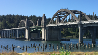
The Siuslaw River Bridge is a bascule bridge that spans the Siuslaw River on U.S. Route 101 in Florence, Oregon. It was designed by Conde McCullough, built by the Mercer-Fraser Company of Eureka, California, and funded by the Federal Emergency Administration of Public Works. It opened in 1936.
The Rip Van Winkle Bridge is a 5,040 ft (1,540 m) cantilever bridge spanning the Hudson River between Hudson, New York and Catskill, New York. Affording 145 feet (44 m) of clearance over the water, the structure carries NY 23 across the river, connecting US 9W and NY 385 on the west side with NY 9G on the east side. The bridge is named after the 1819 short story of the same name by Washington Irving, which mentions Hudson and Catskill.

The Dent Bridge is a suspension bridge in the northwest United States, located in north central Idaho in Clearwater County, north of Orofino. It is 17 miles (27 km) up the North Fork of the Clearwater River, now Dworshak Reservoir. Completed 52 years ago in 1971 at a cost of $7,848,950, it has a main span of 1,050 feet (320 m), and an overall length of 1,550 feet (472 m).

The Hope Memorial Bridge is a 4,490-foot-long (1,370 m) art deco truss bridge crossing the Cuyahoga River in Cleveland, Ohio. The bridge connects Lorain Avenue on Cleveland's west side and Carnegie Avenue on the east side, terminating just short of Progressive Field.
The Bellaire Bridge or Interstate Bridge is a privately owned, closed cantilever truss toll bridge that spans the Ohio River between Benwood, West Virginia and Bellaire, Ohio. It provided a link for commuters between southern Ohio border towns and West Virginia steel mills from 1926 to 1991.
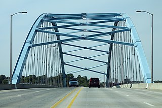
The Amelia Earhart Memorial Bridge is a network tied arch bridge over the Missouri River on U.S. Route 59 between Atchison, Kansas and Buchanan County, Missouri. It opened in December 2012, replacing a previous truss bridge with the same name.

The Hampden County Memorial Bridge is a reinforced-concrete arch bridge that spans the Connecticut River between Springfield, Massachusetts and West Springfield, Massachusetts, constructed in 1922. The bridge is owned by Massachusetts Highway Department and is located on Massachusetts Route 147. It spans 209 feet (64 m) and rises 29.71 feet (9.06 m) above the river.

The Bellows Falls Arch Bridge was a three-hinged steel through arch bridge over the Connecticut River between Bellows Falls, Vermont and North Walpole, New Hampshire. It was structurally significant as the longest arch bridge in the United States when it was completed in 1905.

The Hadley Parabolic Bridge, often referred to locally as the Hadley Bow Bridge, carries Corinth Road across the Sacandaga River in Hadley, New York, United States. It is an iron bridge dating from the late 19th century.

F.J. Torras Causeway is a causeway located in Glynn County, Georgia, USA that connects the city of Brunswick, Georgia to St. Simons Island, Georgia.

The Parvin Bridge is a covered bridge located in Lane County, Oregon, U.S. near Dexter. It was built in 1921 as a single-lane 75-foot (23 m) bridge across Lost Creek, a tributary of the Middle Fork Willamette River.
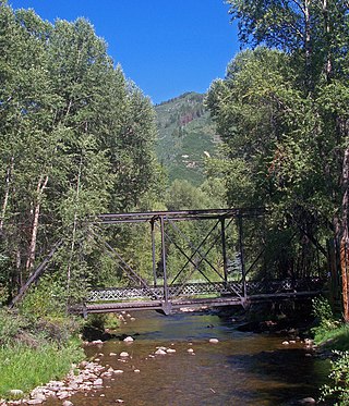
The Sheely Bridge, originally known as the Carbondale Bridge, carries pedestrian traffic across the Roaring Fork River at Mill Street Park in Aspen, Colorado, United States. It is a short steel truss bridge originally located downstream in Carbondale and later moved to its present location.

The Fort Steuben Bridge, originally the Weirton-Steubenville Bridge, was a suspension bridge which spanned the Ohio River from Steubenville, Ohio to Weirton, West Virginia and carried U.S. Route 22 and then Ohio State Route 822 during its existence. Completed in 1928 and opened as a toll bridge, the Fort Steuben Bridge was a more direct route for the flow of traffic across the river; particularly for trucks and heavy vehicles from the industrial area. The Fort Steuben Bridge was weight-restricted in 2006 and closed in 2009 due to deterioration. The bridge was demolished by Joseph B. Fay Co. on February 21, 2012.

Heizer, also called Heizerton, is an unincorporated community in Barton County, Kansas, United States.

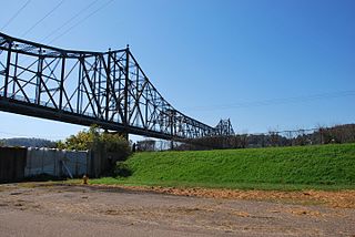
U.S. Route 60 and U.S. Route 62 (US 60/US 62) run for a very short distance within the state of Illinois. The highways run concurrently for their entire existence within the state. The joint highway runs around Fort Defiance in Cairo, from the Cairo Mississippi River Bridge over the Mississippi River east to the Cairo Ohio River Bridge over the Ohio River; the Ohio River Bridge also carries US 51. The bridges cross the two rivers just north of the mouth of the Ohio.

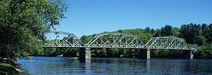
The Ranger Bridge between Wells River, Vermont and Woodsville, New Hampshire, is a three-hinged steel arch truss bridge over the Connecticut River. It was built in 1923 to replace a 1917 bridge. This is the oldest steel arch bridge over the Connecticut River.
The Seneca Road Company was formed to improve the main road running west from Utica, New York, the Genesee Road, from Utica to Canandaigua and operate it as a toll road or turnpike. The road was originally laid out in 1794 from Baggs Square in downtown Utica at the ford of the Mohawk River and followed the Indian trail past Syracuse to Canandaigua. Some accounts say it went to Geneva and Avon originally. There was no City of Syracuse then. The road became known as the Seneca Turnpike, which was 157 miles (253 km) long and, at the time, the longest toll road in the state.

The Maple Street Bridge is a girder bridge in the northwest United States in Spokane, Washington. It spans West Central to Downtown, crossing over the Spokane River and the Peaceful Valley neighborhood. Along with the Division Street Bridge and Monroe Street Bridge, the Maple Street Bridge is one of several major bridges that cross the Spokane River.