Route 29 is a state highway in the U.S. state of New Jersey. Signed north-south, it runs 34.76 mi (55.94 km) from an interchange with Interstate 295 (I-295) in Hamilton Township in Mercer County, where the road continues east as I-195, northwest to Route 12 in Frenchtown, Hunterdon County. Between the southern terminus and I-295 in Ewing Township, the route is a mix of freeway and expressway that runs along the Delaware River through Trenton. This section includes a truck-restricted tunnel that was built along the river near historic houses and Riverview Cemetery. North of I-295, Route 29 turns into a scenic and mostly two-lane highway. North of the South Trenton Tunnel, it is designated the Delaware River Scenic Byway, a New Jersey Scenic Byway and National Scenic Byway, that follows the Delaware River in mostly rural sections of Mercer County and Hunterdon County. The obsolete Delaware & Raritan Canal usually stands between the river and the highway. Most sections of this portion of Route 29 are completely shaded due to the tree canopy. Route 29 also has a spur, Route 129, which connects Route 29 to U.S. Route 1 (US 1) in Trenton.
Franklin Township is a township in Somerset County, in the U.S. state of New Jersey. It is centrally located in the Raritan Valley region, within the New York Metropolitan Area. As of the 2020 United States census, the township's population was 68,364, an increase of 6,064 (+9.7%) from the 2010 census count of 62,300, which in turn reflected an increase of 11,397 (+22.4%) from the 50,903 counted in the 2000 census. The township was the state's 19th most-populous municipality in 2020, after being ranked 22nd in 2010.

The Delaware and Raritan Canal is a canal in central New Jersey, built in the 1830s, that connects the Delaware River to the Raritan River. It was an efficient and reliable means of transportation of freight between Philadelphia and New York City, transporting anthracite coal from eastern Pennsylvania during much of the 19th and early 20th centuries. The canal allowed shippers to cut many miles off the existing route from the Pennsylvania Coal Region down the Delaware, around Cape May, and up the occasionally treacherous Atlantic Ocean coast to New York City.

Washington Crossing State Park is a 3,575-acre (14 km2) New Jersey state park that is part of Washington's Crossing, a U.S. National Historic Landmark area. It is located in the Washington Crossing and Titusville sections of Hopewell Township in Mercer County, north of Trenton along the Delaware River. The park is operated and maintained by the New Jersey Division of Parks and Forestry. It is supported by the Washington Crossing Park Association, a friends group that works to preserve, enhance, and advocate for the park.

Blackwells Mills is an unincorporated community and census-designated place (CDP) located in Franklin Township in Somerset County, in the U.S. state of New Jersey. As of the 2010 U.S. census, the CDP's population was 803.
The Belvidere-Delaware Railroad was a railroad running along the eastern shore of the Delaware River from Trenton, New Jersey north via Phillipsburg, New Jersey to the small village of Manunka Chunk, New Jersey. It became an important feeder line for the Lehigh Valley Railroad's join to the Central Railroad of New Jersey, which was constructed into Phillipsburg, NJ at about the same time. This connected Philadelphia and Trenton, NJ at one end of the shortline railroad to the rapidly growing lower Wyoming Valley region, and via the Morris Canal or the CNJ, a slow or fast connection to New York City ferries crossing New York Harbor from Jersey City, NJ. In 1871 the CNJ leased various railroads in Pennsylvania, most from the Lehigh Coal & Navigation Company allowing the CNJ to penetrate to the upper Wyoming Valley, over some stretches, competing directly with the Lehigh Valley Railroad and with the Lehigh Canal and the trunk road connection of the Belvidere Delaware Railroad to New York became less profitable since Philadelphia connected more easily to Northeastern Pennsylvania thereafter without needing a double-crossing of the Delaware River; a general revenue decline ensued, leading to the Pennsylvania Railroad acquiring the rights, where it served as part of the Pennsylvania Railroad (PRR) system, carrying mainly anthracite coal and iron ore from northeastern Pennsylvania to population centers along the coast.

Griggstown is an unincorporated community and census-designated place (CDP) located within Franklin Township, in Somerset County, in the U.S. state of New Jersey. As of the 2010 United States Census, the CDP's population was 819. The area was first settled around 1733. The Millstone River and the Delaware and Raritan Canal both flow through Griggstown.

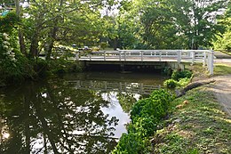
The Blackwells Mills Canal House is located at Blackwells Mills Road and Canal Road in Franklin Township, Somerset County, New Jersey, United States, on the Delaware and Raritan Canal. Across the canal is Blackwells Mills, New Jersey.

East Millstone is an unincorporated community and census-designated place (CDP) located in Franklin Township in Somerset County, in the U.S. state of New Jersey.

The Delaware Division of the Pennsylvania Canal, more commonly called the Delaware Canal, runs for 60 miles (97 km) parallel to the right bank of the Delaware River from the entry locks near the mouth of the Lehigh River and terminal end of the Lehigh Canal at Easton south to Bristol. At Easton, which today is the home of The National Canal Museum, the Delaware Canal also connected with the Morris Canal built to carry anthracite coal to energy-starved New Jersey industries.

Delaware and Raritan Canal State Park is a New Jersey state park along the Delaware and Raritan Canal.

The D&R Canal trail is a recreational trail in the U.S. state of New Jersey. The 77-mile (124 km) trail is made up of three segments that transverse three counties: a canal towpath from New Brunswick to Trenton; a canal towpath/rail trail from Trenton to Bull's Island; and a rail trail from Bull's Island to Frenchtown. The three combined trails together form the largest completed trail in New Jersey. Much of the trail runs along the existing Delaware & Raritan Canal within the Delaware and Raritan Canal State Park.
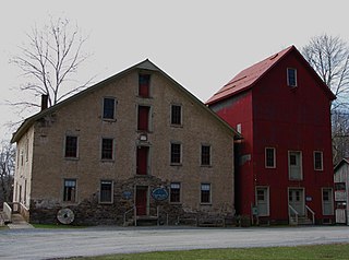
Prallsville is an unincorporated community located along New Jersey Route 29 by the border of Stockton and Delaware Township in Hunterdon County, New Jersey. The Delaware River and Wickecheoke Creek border the community. The Prallsville District was listed on the National Register of Historic Places in 1979.
Weston is an unincorporated community and census-designated place (CDP) located in Franklin Township, in Somerset County, in the U.S. state of New Jersey. As of the 2010 United States Census, the CDP's population was 1,235.

The Lambertville Historic District is a 198-acre (80 ha) historic district encompassing the community centered around the intersection of Route 29 and Route 179 in the city of Lambertville in Hunterdon County, New Jersey, United States. The district was added to the National Register of Historic Places on June 30, 1983, for its significance in architecture, commerce, industry, and settlement. It includes 680 contributing buildings, and two contributing structures.
Wilburtha is a section of Ewing Township in Mercer County, in the U.S. state of New Jersey. Located where Wilburtha Road crosses the Delaware and Raritan Canal, it is one of the oldest settlements in Ewing Township and developed due to the construction of the canal in the early 19th century. The community was known as Greensburg before adopting its current name in 1883. The Yardley–Wilburtha Bridge once connected Wilburtha to Yardley, Pennsylvania on the other side of the Delaware River. The Belvidere Delaware Railroad once passed through the village. Today, Wilburtha is primarily a residential neighborhood consisting of detached, single-family homes, the majority of which were built in the 1950s through the early 1980s. There are still many Georgian and Federal-style homes found in the area.

Washington Crossing, New Jersey is an unincorporated community and census-designated place (CDP) located within Hopewell Township in Mercer County, in the U.S. state of New Jersey. The CDP and surrounding Hopewell Township lie on the eastern flank of the Washington Crossing Bridge spanning the Delaware River. Washington Crossing State Park is located adjacent to the community in New Jersey while across the river lies Washington Crossing Historic Park in Washington Crossing, Pennsylvania. As of the 2020 United States census, the CDP's population was 371.
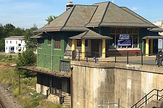
Phillipsburg Union Station is an active railroad station museum, in Phillipsburg, New Jersey, United States, at 178 South Main Street. Opened in 1914, Union Station was built by the Delaware, Lackawanna & Western Railroad (DL&W) and shared with the Central Railroad of New Jersey (CNJ) and was situated where the lines merged before the bridge crossing the Delaware River. Designed by Frank J. Nies, the architect who produced many of DL&W stations now listed state and federal registers of historic places, the 2+1⁄2 story, 3 bay brick building is unusual example of a union station and a representation of early 20th century Prairie style architecture. The Phillipsburg Union Signal Tower, or PU Tower, is nearby, also restored to its original form, and available for tours.

Pursley's Ferry Historic District is a 61-acre (25 ha) historic district located along Old River Road near Church Road by the Delaware River in Holland Township, Hunterdon County, New Jersey. It was added to the National Register of Historic Places on October 8, 1980 for its significance in architecture, commerce, and transportation. The district includes 4 contributing buildings.
William Hartwell Blackwell was an American fruit farmer and politician from New Jersey.