Ewing Township is a township in Mercer County, in the U.S. state of New Jersey. The township falls within the New York metropolitan area as defined by the U.S. Census Bureau. It borders the Philadelphia metropolitan area and is part of the Federal Communications Commission's Philadelphia Designated Market Area. As of the 2020 United States census, the township's population was 37,264, its highest decennial count ever and an increase of 1,474 (+4.1%) from the 35,790 recorded at the 2010 census, which in turn reflected an increase of 83 (+0.2%) from the 35,707 counted in the 2000 census.

Hopewell is a borough in Mercer County, in the U.S. state of New Jersey. This historical settlement is located within the heart of the Raritan Valley region. As of the 2020 United States census, the borough's population was 1,918, a decrease of 4 (−0.2%) from the 2010 census count of 1,922, which in turn had reflected a decline of 113 (−5.6%) from the 2,035 counted in the 2000 census.

Hopewell Township is a township in Mercer County, in the U.S. state of New Jersey. Located within the Raritan Valley region, the township is an exurb of New York City in the New York metropolitan area as defined by the United States Census Bureau, while also directly bordering the Philadelphia metropolitan area, being a part of the Federal Communications Commission's Philadelphia Designated Market Area. As of the 2020 United States census, the township's population was 17,491, its highest decennial count ever and an increase of 187 (+1.1%) from the 2010 census count of 17,304, which in turn reflected an increase of 1,199 (+7.4%) from the 16,105 counted in the 2000 census.
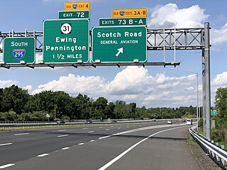
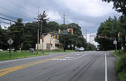
Pennington is a borough in Mercer County, in the U.S. state of New Jersey. The borough is located at the cross-roads between the Delaware Valley region to the south and the Raritan Valley region to the north. As of the 2020 United States census, the borough's population was 2,802, its highest decennial count ever and an increase of 217 (+8.4%) from the 2010 census count of 2,585, which in turn had reflected a decline of 111 (−4.1%) from the 2,696 counted in the 2000 census.

Washington Crossing State Park is a 3,575-acre (14 km2) New Jersey state park that is part of Washington's Crossing, a U.S. National Historic Landmark area. It is located in the Washington Crossing and Titusville sections of Hopewell Township in Mercer County, north of Trenton along the Delaware River. The park is operated and maintained by the New Jersey Division of Parks and Forestry. It is supported by the Washington Crossing Park Association, a friends group that works to preserve, enhance, and advocate for the park.
Hopewell Valley is a group of communities in Mercer County, New Jersey loosely affiliated through municipal service sharing agreements, all of which send their students to the Hopewell Valley Regional School District.

Titusville is an unincorporated community and census-designated place (CDP) located within Hopewell Township in Mercer County, in the U.S. state of New Jersey. The area includes a post office with its own ZIP Code (08560), several restaurants, gas stations, a firehouse, and a small cluster of homes. The Washington Crossing State Park, dedicated to George Washington's crossing of the Delaware River in 1776, is adjacent to the community.

Pluckemin is an unincorporated community and census-designated place (CDP) located within Bedminster Township, in Somerset County, in the U.S. state of New Jersey. It was also known historically as Pluckamin. It was the site of several historic events during the American Revolutionary War.
The Hopewell Valley Regional School District is a comprehensive regional public school district serving students in pre-kindergarten through twelfth grade from three communities in Mercer County, New Jersey, United States. The municipalities that are part of this district are Hopewell Borough, Hopewell Township and Pennington Borough.

John Warner Barber was an American engraver and historian whose books of state, national, and local history featured his vivid illustrations, said to have caught the flavor and appearance of city, town, and countryside scenes in his day.

West Trenton is an unincorporated community within Ewing Township in Mercer County, New Jersey, United States. It is a suburban area located adjacent to the northwestern portion of the city of Trenton, from which it derives its name. Located at the intersection of Bear Tavern Road/Grand Avenue and West Upper Ferry Road, it is one of the oldest settlements in Ewing Township.

Whitehouse, also spelled White House, is an unincorporated community located within Readington Township in Hunterdon County, New Jersey. The community lies along the former Jersey Turnpike, just west of Mechanicsville. The Whitehouse–Mechanicsville Historic District, which includes historic places in both Whitehouse and Mechanicsville, was added to the National Register of Historic Places on March 17, 2015.

Liberty Corner is an unincorporated community and census-designated place (CDP) located in Bernards Township, in Somerset County, in the U.S. state of New Jersey. Liberty Corner is about 3+3⁄4 miles (6.0 km) south of Bernardsville. Liberty Corner has a post office with ZIP code 07938. The Liberty Corner Historic District was listed on the state and national registers of historic places in 1991.
Mechanicsville is an unincorporated community located within Readington Township in Hunterdon County, in the U.S. state of New Jersey. It is located along present day US Route 22, just east of Whitehouse near the intersection of Lamington Road. The hamlet once had a tavern, a store, numerous mechanic shops as well as a number of residences. As Whitehouse and Mechanicsville lost many of the businesses along the main road, the two hamlets eventually merged. The Whitehouse General Store, the East Whitehouse Fire Department and the Whitehouse United Methodist Church are in the section of Whitehouse that used to be Mechanicsville. The Ryland Inn was located in this section of Whitehouse.

The Sourlands is a region in the US state of New Jersey that includes portions of Hunterdon County, Mercer County and Somerset County. It is centered on Sourland Mountain and comprises parts of Lambertville, East Amwell, West Amwell, Hillsborough, Hopewell Boro, Hopewell Township, and Montgomery Township. The region is flanked by the Hopewell Fault to the south and Amwell Valley to the north that runs from Mount Airy to an area just west of Flagtown and a diabase formation running from Lambertville to Mount Airy. The Sourland also include a hilly area towards the southwest called Pleasant Valley, with a number of farms. Although much of the Sourlands is not conducive to farming, Pleasant Valley and the slopes on the surrounding ridges have a number of farms. The slopes of the ridge to the north are also home to Unionville Vineyard.

Henry Howe was an American author who wrote histories of several states in the United States. His most celebrated work is the three volume Historical Collections of Ohio.
Roadstown is an unincorporated community located within Stow Creek Township, in Cumberland County, in the U.S. state of New Jersey.
Allerton is an unincorporated community located within Clinton Township, in Hunterdon County, in the U.S. state of New Jersey.
Washington Crossing, New Jersey is an unincorporated community and census-designated place (CDP) located within Hopewell Township in Mercer County, in the U.S. state of New Jersey. The CDP and surrounding Hopewell Township lie on the eastern flank of the Washington Crossing Bridge spanning the Delaware River, across from Washington Crossing State Park in Washington Crossing, Pennsylvania. As of the 2020 United States census, the CDP's population was 371.
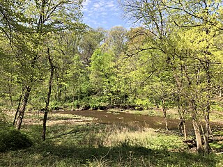
Jacobs Creek is a tributary of the Delaware River in Mercer County in the U.S. state of New Jersey. From its headwaters in Hopewell Township, the creek flows generally south and southwest. Along the creek's lower course, it flows along the border between Hopewell Township and Ewing Township, entering the Delaware River between Lambertville and Trenton.