Lawrenceville, New Jersey | |
---|---|
Location in Mercer County Location in New Jersey | |
Coordinates: 40°18′10″N74°44′17″W / 40.302787°N 74.738004°W | |
Country | United States |
State | New Jersey |
County | Mercer |
Township | Lawrence |
Named for | Maidenhead, England |
Area | |
• Total | 1.04 sq mi (2.70 km2) |
• Land | 1.04 sq mi (2.70 km2) |
• Water | 0.00 sq mi (0.00 km2) 0.09% |
Elevation | 184 ft (56 m) |
Population | |
• Total | 3,751 |
• Density | 3,606.7/sq mi (1,392.6/km2) |
Time zone | UTC−05:00 (Eastern (EST)) |
• Summer (DST) | UTC−04:00 (Eastern (EDT)) |
ZIP Code | 08648 - Lawrence Township [4] |
Area code | 609 |
FIPS code | 34-39570 [5] [6] |
GNIS feature ID | 02390044 [7] |
Lawrenceville is an unincorporated community and census-designated place (CDP) and a major commercial hub within Lawrence Township in Mercer County, in the U.S. state of New Jersey. [8] [9] [10] The community is situated roughly halfway between Princeton and Trenton, although Lawrenceville constitutes part of the New York metropolitan area, the CDP actually is located approximately 15 miles closer to Philadelphia than to New York City; and as with the remainder of Mercer County, lies within the Federal Communications Commission's Philadelphia Designated Market Area. As of the 2020 United States census, the CDP's population was 3,751, a decrease of 136 (−3.5%) from the 3,887 recorded at the 2010 census, [11] which in turn had reflected a decrease of 194 (−4.8%) from the 4,081 counted in the 2000 census. [12]
Lawrenceville is also known as the "village of Lawrenceville". [13] Its core is the Main Street Historic District, which was listed both in the New Jersey Register of Historic Places and National Register of Historic Places in 1972, and was one of the first registered historic districts in New Jersey. [14]
Lawrenceville was founded as Maidenhead in 1697, as part of Burlington County in the colony of West Jersey. In 1714, the village became a part of Hunterdon County. In 1798, the New Jersey Legislature legally incorporated the Township of Maidenhead.
The village was originally named for Maidenhead, a historic English town on the Thames River, about 30 miles west from London. The Colonial Supreme Court at Burlington officially confirmed the name on February 20, 1697. "Maidenhead" derives from the Anglo Saxon word "Maidenhythe," meaning "new wharf", though it acquired a secondary meaning as a term for virginity. [15]
The Rev. Issac V. Brown, the first full-time pastor of the Presbyterian Church of Lawrenceville and the founder of the Academy of Maidenhead (now the Lawrenceville School), led a movement to petition the Legislature to change the town's name. The petition said "... it must be the wish of every good citizen... to be relieved of the necessity of using a term which may offend the delicacy of modesty, or disturb the feelings of seriousness, or excite the sneers of the willing". [16]
The Legislature officially changed the name from Maidenhead to Lawrence on January 24, 1816, at a meeting in John Moore's Tavern. The township took its name from Captain James Lawrence, a naval hero of the War of 1812. The village was renamed Lawrenceville at the same time. In 1838, Mercer County was formed from parts of three counties, and Lawrence Township was included in the new County. The Township's boundaries and geographic relationships have remained the same since that time.
During the American Revolutionary War, George Washington's troops marched through Maidenhead after the Battle of Trenton (December 26, 1776) and the Battle of the Assunpink Creek (January 2, 1777), chasing British troops. They met at the Battle of Princeton on January 3, 1777, just over the township line, where the Princeton Battlefield State Park now stands.
Cornwallis stayed overnight in Maidenhead on December 8, 1776, en route to Trenton. Cornwallis recorded the moment in his diary, a portion of which was found years later in John Moore's Tavern, which is now a residential house at 2695 Main Street. His opinion of the village was that "one night in Maidenhead was more than enough". [17]
When the Presbyterian Church of Lawrenceville was built in 1698, it was called the Meetinghouse of Maidenhead. It is still serving the community at 2688 Main Street.
According to the United States Census Bureau, the CDP had a total area of 1.043 square miles (2.701 km2), including 1.042 square miles (2.698 km2) of land and 0.001 square miles (0.002 km2) of water (0.09%). [18] [19]
U.S. Route 206 changes its name from "Lawrenceville-Princeton Road" to "Main Street", and then to "Lawrenceville-Trenton Road" in the center of Lawrenceville. The local historic district fronts along Main Street and US 206 stretch for more than two miles between Franklin Corner Road and an area slightly north of Fackler Road. Homes situated more than 250 feet from the road are excluded, however. One exception is the section of The Lawrenceville School known as the Circle and several other buildings in its vicinity, the oldest buildings on the campus. This area itself has been designated a National Historic Landmark. [14]
Lawrenceville generally comprises the area contained within Lawrenceville-Pennington Road to the south, Fackler Road to the north, Keefe Road to the west, and US 206, part of which turns into Main Street in Lawrenceville, to the east. The Lawrenceville School, across Route 206, is usually considered part of the village as well. Before tract development, beginning in the early 1970s, Lawrenceville was broadly defined as stretching two to three blocks back from Route 206. The boundary became less clear as residential developments replaced farmland behind the historic village.
Lawrence Township is occasionally and mistakenly referred to as Lawrenceville. The confusion is partly caused because the local post office is located in the Lawrenceville CDP and the Postal Service once instructed Lawrence Township residents to use Lawrenceville, Princeton or Trenton as their mailing address. In 1973, voters approved a nonbinding referendum to petition the U.S. Postal Service to adopt a single municipal post office address known as Lawrenceville for the entire township; The effort failed. A township resident appeared before Township Council in July, 2007, to request to designate the 08648 ZIP code for Lawrence Township. Council approved a resolution in support of the request that was then forwarded to the U.S. Postal Service. Township officials had fought, off and on, for the change since 1969, when then-U.S. Rep. Frank Thompson tried unsuccessfully to convince U.S. Postal Service authorities to grant a Lawrence name tag for the entire township, according to a letter on file at the Municipal Clerk's Office. The United States Postal Service notified the township authorities in October 2007 that the preferred designation for the 08648 would be changed to "Lawrence Township". [20]
Lawrenceville is equidistant between Trenton and Princeton, New Jersey and approximately fifteen miles closer to Philadelphia than to New York City. Major transportation corridors have passed through Lawrenceville since the town's inception, including The King's Highway, which in the 18th century approximated today's U.S. Route 206. [21] The predominant highway and commercial corridor through Lawrenceville is New Jersey State Route 1.
Census | Pop. | Note | %± |
---|---|---|---|
1990 | 6,446 | — | |
2000 | 4,081 | * | −36.7% |
2010 | 3,887 | −4.8% | |
2020 | 3,751 | −3.5% | |
Population sources: 1990-2010 [9] 2000 [12] 2010 [11] 2020 [3] * = Lost territory during previous decade. |
The 2010 United States census counted 3,887 people, 1,734 households, and 1,046 families in the CDP. The population density was 3,731.1 per square mile (1,440.6/km2). There were 1,805 housing units at an average density of 1,732.6 per square mile (669.0/km2). The racial makeup was 85.16% (3,310) White, 3.99% (155) Black or African American, 0.10% (4) Native American, 7.77% (302) Asian, 0.00% (0) Pacific Islander, 0.80% (31) from other races, and 2.19% (85) from two or more races. Hispanic or Latino of any race were 4.32% (168) of the population. [11]
Of the 1,734 households, 27.1% had children under the age of 18; 48.5% were married couples living together; 9.5% had a female householder with no husband present and 39.7% were non-families. Of all households, 33.1% were made up of individuals and 9.1% had someone living alone who was 65 years of age or older. The average household size was 2.24 and the average family size was 2.90. [11]
20.6% of the population were under the age of 18, 5.9% from 18 to 24, 25.8% from 25 to 44, 35.3% from 45 to 64, and 12.3% who were 65 years of age or older. The median age was 43.2 years. For every 100 females, the population had 82.5 males. For every 100 females ages 18 and older there were 78.6 males. [11]
As of the 2000 United States Census [5] there were 4,081 people, 1,747 households, and 1,070 families residing in the CDP. The population density was 1,515.1/km2 (3,926.5/mi2). There were 1,776 housing units at an average density of 659.3/km2 (1,708.7/mi2). The racial makeup of the CDP was 88.12% White, 3.58% African American, 0.07% Native American, 6.30% Asian, 0.54% from other races, and 1.40% from two or more races. Hispanic or Latino of any race were 3.46% of the population. [12]
Of the 1,747 households, 32.2% had children under the age of 18 living with them; 48.7% were married couples living together; 10.5% had a female householder with no husband present; and 38.7% were non-families. 32.3% of all households were made up of individuals, and 8.6% had someone living alone who was 65 years of age or older. The average household size was 2.33 and the average family size was 2.99. [12]
In the CDP the population was spread out, with 24.2% under the age of 18; 5.8% from 18 to 24; 32.2% from 25 to 44; 27.7% from 45 to 64; and 10.1% who were 65 years of age or older. The median age was 39 years. For every 100 females, there were 83.7 males. For every 100 females age 18 and over, there were 77.7 males. [12]
The median income for a household in the CDP as of the year 2000 was $74,107. The median income for a family was $98,972. Males had a median income of $65,189 versus $37,972 for females. The per capita income for the CDP was $37,919. About 0.6% of families and 1.7% of the population were below the poverty line, including none of those under age 18 and 4.1% of those age 65 or over. [12]
The Lawrenceville Elementary School, one of Lawrence Township Public Schools' four elementary schools, is located in Lawrenceville.
Lawrenceville is home to the Lawrenceville School, a private boarding and day high school founded in 1810. It is one of the oldest and most prestigious prep schools in the United States.
Historically, the Lawrenceville School was the dominant economic force in the village. Since World War II, Lawrenceville has become a commuter town, serving educational and corporate employment centers in Lawrence Township, in Princeton and Trenton, in the surrounding cluster of corporate and research campuses, and to a lesser extent in New York City. There are no large businesses in Lawrenceville itself, but Lawrence Township is home to several large corporate facilities outside of the village, including the world headquarters of Educational Testing Service, offices for the Lenox division of Department 56, the main research facility for Bristol Myers Squibb, and the offices of the Peterson's division of Nelnet.
The village businesses share an organization, Lawrenceville Main Street, which organizes events, such as the Music in the Park series, the annual Jubilee, and Taste of Lawrenceville, and promotes the business district to visitors. The Lawrenceville Farmers Market is held every Sunday, from about June to November. [22]
The Lawrenceville Fire Co., Lawrenceville Water Co. (now part of Aqua America), Lawrenceville Fuel, and a U.S. Post Office are also located in Lawrenceville.
Lawrenceville was formerly home to a family grocery, hardware store, pharmacy, and, most famously, the Jigger Shop, which served generations of Lawrenceville School students as a school store and soda fountain. [23] A fire destroyed the shop on August 10, 1990. Caused by faulty electrical cords that ran to a store refrigerator, the fire burned through the store's ceiling into the second-floor apartment, which was unoccupied . A new Jigger Shop then opened at The Lawrenceville School and was located on the first floor of the Noyes History Building, until its relocation to the Irwin Dining Center in 2011. After the demolition of the Irwin Dining Center in early 2023, the Jigger Shop was renamed to the Big Red Store and relocated to the newly-built Tsai Field House. [24]
The offices of the Princeton Area Community Foundation are in Lawrenceville. [25]
People who were born in, residents of, or otherwise closely associated with Lawrenceville include:
Mercer County is a county located in the U.S. state of New Jersey. Its county seat is Trenton, also the state capital, prompting its nickname The Capital County. Mercer County alone constitutes the Trenton–Princeton metropolitan statistical area and is considered part of the New York combined statistical area by the U.S. Census Bureau, but also directly borders the Philadelphia metropolitan area and is included within the Federal Communications Commission's Philadelphia Designated Media Market Area.
Strathmere is an unincorporated community and census-designated place (CDP) located within Upper Township in Cape May County, in the U.S. state of New Jersey. As of the 2020 United States census, the CDP's population was 137, a decrease of 21 (−13.3%) from the 158 counted at the 2010 U.S. census, which reflected a decrease of 17 (−9.7%) from the 175 enumerated at the 2000 census.
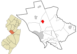
Lawrence Township is a township in Mercer County, in the U.S. state of New Jersey. Located at the cross-roads between the Delaware Valley region to the south and the Raritan Valley region to the north, the township is an outer-ring suburb of New York City in the New York Metropolitan area, as defined by the United States Census Bureau, while also directly bordering the Philadelphia metropolitan area and is part of the Federal Communications Commission's Philadelphia Designated Market Area. The township is a regional commercial hub for central New Jersey. As of the 2020 United States census, the township's population was 33,077, a decrease of 395 (−1.2%) from the 2010 census count of 33,472, which in turn reflected an increase of 4,313 (+14.8%) from the 29,159 counted in the 2000 census.
Princeton Township was a township in Mercer County, New Jersey, United States, that existed from 1838 until it was dissolved after it was merged with Princeton Borough in 2013 to form Princeton, New Jersey. As of the 2010 United States Census, the township's population was 16,265, reflecting an increase of 238 (+1.5%) from the 16,027 counted in the 2000 Census, which had in turn increased by 2,829 (+21.4%) from the 13,198 counted in the 1990 Census.
Princeton Junction is an unincorporated community and census-designated place (CDP) located within West Windsor, in Mercer County, in the U.S. state of New Jersey. As of the 2010 United States Census, the CDP's population was 2,465.
Kingston is an unincorporated community and census designated place (CDP) along the border of South Brunswick Township in Middlesex County and Franklin Township in Somerset County, and also located relatively near Princeton in Mercer County in the U.S. state of New Jersey. The historic settlement is in the Raritan Valley region, located along the course of the Millstone River. As of the 2010 United States Census, the CDP's population was 1,493, of which 1,222 were in South Brunswick Township and 271 in Franklin Township.
Plainsboro Center is an unincorporated community and census-designated place (CDP) located within Plainsboro Township, situated in southern Middlesex County, within the U.S. state of New Jersey. As of the 2020 United States census, the CDP's population was 2,760, its highest decennial count ever and an increase of 48 (+1.8%) from the 2,712 recorded at the 2010 census, which in turn reflected an increase of 503 (+22.8%) from the 2,209 counted in the 2000 census.
Lincroft is an unincorporated community and census-designated place (CDP) within Middletown Township, in Monmouth County, in the U.S. state of New Jersey. As of the 2020 United States census, the CDP had a population of 7,060, reflecting a 15.1% increase from the 6,135 residents enumerated at the 2010 U.S. Census, in turn a decline of 120 residents (-1.9%) from the 6,255 counted in the 2000 U.S. Census.
Morganville is an unincorporated community and census-designated place (CDP) within Marlboro Township, in Monmouth County, New Jersey. As of the 2010 United States Census, the CDP's population was 5,040.
Manahawkin is an unincorporated community and census-designated place (CDP) located within Stafford Township, in Ocean County, in the U.S. state of New Jersey. As of the 2020 United States census, the CDP's population was 2,413, its highest decennial count ever and an increase of 110 (+4.8%) from the 2,303 recorded at the 2010 census, which in turn had reflected an increase of 299 (+14.9%) from the 2,004 counted at the 2000 census. Manahawkin has been thought to be a Lenape word meaning "land of good corn", although this has been disputed by recent scholars claiming that it translates to "fertile land sloping into the water."
New Egypt is an unincorporated community and census-designated place (CDP) located within Plumsted Township, in Ocean County, in the U.S. state of New Jersey. As of the 2010 United States Census, the CDP's population was 2,512. The community is located at the trijunction of Burlington County, Monmouth County and Ocean counties.
Clarksburg is an unincorporated community located within Millstone Township in Monmouth County, in the U.S. state of New Jersey. The area is served as United States Postal Service ZIP code 08510.
Griggstown is an unincorporated community and census-designated place (CDP) located within Franklin Township, in Somerset County, in the U.S. state of New Jersey. As of the 2010 United States Census, the CDP's population was 819. The area was first settled around 1733.
East Millstone is an unincorporated community and census-designated place (CDP) located in Franklin Township in Somerset County, in the U.S. state of New Jersey.
Robbinsville is a census-designated place (CDP) located within Robbinsville Township in Mercer County, in the U.S. state of New Jersey. The area is served as United States Postal Service ZIP Code 08691. As of the 2010 United States Census, the population for the CDP was 3,041.
Skillman is an unincorporated community and census-designated place (CDP) located within Montgomery Township, in Somerset County, in the U.S. state of New Jersey. As of the 2010 United States Census, the CDP's population was 242.
Franklin Park is an unincorporated community and census-designated place (CDP) located within Franklin Township, in Somerset County, in the U.S. state of New Jersey. As of the 2010 United States Census, the CDP's population was 13,295. Route 27 bisects the village and serves as the dividing line between the two counties. The adjacent sections of South Brunswick and North Brunswick, Middlesex County on the east side of Route 27 are also known as Franklin Park, but are not included within the CDP's boundaries.
Roebling is an unincorporated community and census-designated place (CDP) located within Florence Township, in Burlington County, in the U.S. state of New Jersey, that was established as part of the 2010 United States census. As of the 2000 United States census, the CDP was combined as Florence-Roebling, which had a total population of 8,200. As of the 2010 Census, the Florence-Roebling CDP was split into its components, Florence and Roebling. As of the 2010 Census, the population of the Florence CDP was 4,426.
Mercerville is an unincorporated community and census-designated place (CDP) located within Hamilton Township, in Mercer County, in the U.S. state of New Jersey. As of the 2010 United States Census, the CDP's population was 13,230. Until after the 2000 census, the area was part of the Mercerville-Hamilton Square CDP. For the 2010 Census it was split into two CDPs, Mercerville and Hamilton Square.
Hamilton Square is an unincorporated community and census-designated place (CDP) located within Hamilton Township, in Mercer County, in the U.S. state of New Jersey, that is the site of a historic colonial village. Until the 2000 census the area was part of the Mercerville-Hamilton Square CDP, which was split into two CDPs as of 2010: Mercerville and Hamilton Square. As of the 2010 United States Census, the CDP's population was 12,784.