Ewing Township is a township in Mercer County, in the U.S. state of New Jersey. The township falls within the New York metropolitan area as defined by the U.S. Census Bureau. It borders the Philadelphia metropolitan area and is part of the Federal Communications Commission's Philadelphia Designated Market Area. As of the 2020 United States census, the township's population was 37,264, its highest decennial count ever and an increase of 1,474 (+4.1%) from the 35,790 recorded at the 2010 census, which in turn reflected an increase of 83 (+0.2%) from the 35,707 counted in the 2000 census.

Lawrence Township is a township in Mercer County, in the U.S. state of New Jersey. Located at the cross-roads between the Delaware Valley region to the south and the Raritan Valley region to the north, the township is an outer-ring suburb of New York City in the New York Metropolitan area, as defined by the United States Census Bureau, while also directly bordering the Philadelphia metropolitan area and is part of the Federal Communications Commission's Philadelphia Designated Market Area. The township is a regional commercial hub for central New Jersey. As of the 2020 United States census, the township's population was 33,077, a decrease of 395 (−1.2%) from the 2010 census count of 33,472, which in turn reflected an increase of 4,313 (+14.8%) from the 29,159 counted in the 2000 census.

West Windsor is a township in Mercer County, in the U.S. state of New Jersey. Located within the Raritan Valley region, the township is an outer-ring suburb of New York City in the New York metropolitan area, as defined by the United States Census Bureau. As of the 2020 United States census, the township's population was 29,518, its highest decennial count ever and an increase of 2,353 (+8.7%) from the 27,165 recorded at the 2010 census, which in turn reflected an increase of 5,258 (+24.0%) from the 21,907 counted in the 2000 census.

The Raritan River is a major river of New Jersey. Its watershed drains much of the mountainous area of the central part of the state, emptying into the Raritan Bay on the Atlantic Ocean.

The Delaware and Raritan Canal is a canal in central New Jersey, built in the 1830s, that connects the Delaware River to the Raritan River. It was an efficient and reliable means of transportation of freight between Philadelphia and New York City, transporting anthracite coal from eastern Pennsylvania during much of the 19th and early 20th centuries. The canal allowed shippers to cut many miles off the existing route from the Pennsylvania Coal Region down the Delaware, around Cape May, and up the occasionally treacherous Atlantic Ocean coast to New York City.

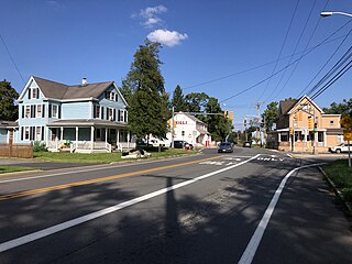
Blackwells Mills is an unincorporated community and census-designated place (CDP) located in Franklin Township in Somerset County, in the U.S. state of New Jersey. As of the 2010 U.S. census, the CDP's population was 803.

Titusville is an unincorporated community and census-designated place (CDP) located within Hopewell Township in Mercer County, in the U.S. state of New Jersey. The area includes a post office with its own ZIP Code (08560), several restaurants, gas stations, a firehouse, and a small cluster of homes. The Washington Crossing State Park, dedicated to George Washington's crossing of the Delaware River in 1776, is adjacent to the community.

The Millstone River is a 38.6-mile-long (62.1 km) tributary of the Raritan River in central New Jersey in the United States.

Raritan Landing is a historical unincorporated community located within Piscataway Township in Middlesex County, in the U.S. state of New Jersey, which was once an inland port, the farthest upstream point ocean-going ships could reach along the Raritan River, across from New Brunswick. Begun in the early 18th century it remained vital until the mid 19th century, when most of the port was abandoned.
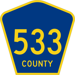
County Route 533 is a county highway in the U.S. state of New Jersey. The highway extends 32.78 miles (52.75 km) from the White Horse Circle, in Hamilton Township to Middlesex CR 607 on the border of Bound Brook and Middlesex Borough. CR 533 shares a long concurrency with U.S. Route 206 through Princeton and Montgomery Township, while portions of the roadway in Somerset County are part of the Millstone River Valley Scenic Byway.

The Blackwells Mills Canal House is located at Blackwells Mills Road and Canal Road in Franklin Township, Somerset County, New Jersey, United States, on the Delaware and Raritan Canal. Across the canal is Blackwells Mills, New Jersey.

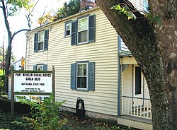
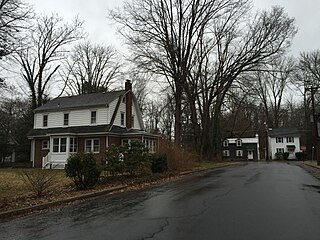
The Port Mercer Canal House is a historic house along the Delaware and Raritan Canal. It is located at 4278 Quakerbridge Road in the Port Mercer section of Lawrence Township, Mercer County, New Jersey, United States, near the border of West Windsor Township and Princeton, New Jersey. The house was built in the 1830s as housing for bridgetender and his family. The bridgetender was needed to open the swing bridge when canal boats came through, then close it to allow traffic to cross over the canal. From approximately 1900 to 1934, the bridgetender was John Arrowsmith. He and his wife lived in the three-bedroom house with their eight children. The Arrowsmiths loved living at the house and their children enjoyed sleeping outside by the canal in the summer and skating on the frozen canal to Trenton in the winter. Around 1900, a first-floor kitchen was added. Prior to this addition, Mrs. Arrowsmith, who was known as a good cook, did all of the cooking for the large family and friends by the fireplace in the basement of the house.
Prallsville is an unincorporated community located along New Jersey Route 29 by the border of Stockton and Delaware Township in Hunterdon County, New Jersey. The Delaware River and Wickecheoke Creek border the community. The Prallsville District was listed on the National Register of Historic Places in 1979.
Wilburtha is a section of Ewing Township in Mercer County, in the U.S. state of New Jersey. Located where Wilburtha Road crosses the Delaware and Raritan Canal, it is one of the oldest settlements in Ewing Township and developed due to the construction of the canal in the early 19th century. The community was known as Greensburg before adopting its current name in 1883. The Yardley–Wilburtha Bridge once connected Wilburtha to Yardley, Pennsylvania on the other side of the Delaware River. The Belvidere Delaware Railroad once passed through the village. Today, Wilburtha is primarily a residential neighborhood consisting of detached, single-family homes, the majority of which were built in the 1950s through the early 1980s. There are still many Georgian and Federal-style homes found in the area.
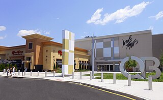
Clarksville is an unincorporated community partially in Lawrence Township, and partially in West Windsor Township, in Mercer County, in the U.S. state of New Jersey. It was historically centered at the intersection of the Trenton-New Brunswick Turnpike, Quakerbridge Road and Province Line Road, and had a blacksmith shop, saloon, store, hotel and school. Today, Clarksville is dominated by several large shopping centers, including the Quaker Bridge Mall.

Readingsburg, also known as Stone Mill, is an unincorporated community located along the South Branch Raritan River within Clinton Township in Hunterdon County, New Jersey.

Washington Crossing, New Jersey is an unincorporated community and census-designated place (CDP) located within Hopewell Township in Mercer County, in the U.S. state of New Jersey. The CDP and surrounding Hopewell Township lie on the eastern flank of the Washington Crossing Bridge spanning the Delaware River, across from Washington Crossing State Park in Washington Crossing, Pennsylvania. As of the 2020 United States census, the CDP's population was 371.
Edinburg is a 1700s-era unincorporated community located within West Windsor in Mercer County, in the U.S. state of New Jersey. The community is located at the junction of Old Trenton Road, Edinburg Road, and Windsor Road.

The King's Highway Historic District covers the portions of U.S. Route 206 and New Jersey Route 27 in New Jersey that connect Lawrenceville with Kingston through Princeton. This historic roadway dates to colonial times and was a portion of the King's Highway that was laid out by order of Charles II of England to connect Boston with Charleston. It is lined with many institutions and sites that have played an important role in the History of the United States, including Princeton University and the Princeton Theological Seminary.

The Washington Road Elm Allée is a 0.7-mile-long (1.1 km) stretch of Washington Road in West Windsor, New Jersey that is lined with Princeton Elm trees. The allée runs through the West Windsor fields of Princeton University and provides, along with the bridge over Lake Carnegie, a dramatic entrance to the campus. The Delaware and Raritan Canal can be found at the northern end of the allée, just before the lake. A jogging path runs through the allée and connects to the canal towpath, the main campus of the university, and other trails through the adjacent fields.