Route 27 is a state highway in New Jersey, United States. It runs 38.53 mi (62.01 km) from U.S. Route 206 (US 206) in Princeton, Mercer County northeast to an interchange with Route 21 and Broad Street in Newark, Essex County. The route passes through many communities along the way, including New Brunswick, Highland Park, Edison, Metuchen, Rahway, and Elizabeth. Route 27 is a two- to four-lane undivided highway for most of its length, passing through a variety of urban and suburban environments. It intersects many roads along the way, including Route 18 in New Brunswick, Interstate 287 (I-287) in Edison, the Garden State Parkway in Woodbridge Township, Route 35 in Rahway, Route 28 in Elizabeth, and U.S. Route 22 in Newark. Route 27 crosses the Raritan River on the Albany Street Bridge, which connects Highland Park on the east with New Brunswick on the west.

West Windsor is a township in Mercer County, in the U.S. state of New Jersey. Located at the cross-roads between the Delaware Valley region to the southwest and the Raritan Valley region to the northeast, the township is considered to be an outer-ring suburb of New York City in the New York metropolitan area, as defined by the United States Census Bureau. As of the 2020 United States census, the township's population was 29,518, its highest decennial count ever and an increase of 2,353 (+8.7%) from the 27,165 recorded at the 2010 census, which in turn reflected an increase of 5,258 (+24.0%) from the 21,907 counted in the 2000 census.

U.S. Route 130 is a U.S. Highway that is a spur route of US 30, located completely within the state of New Jersey. It is signed with north and south cardinal directions, following a general northeast–southwest diagonal path, with north corresponding to the general eastward direction and vice versa. The route runs 83.46 mi (134.32 km) from Interstate 295 (I-295) and US 40 at Deepwater in Pennsville Township, Salem County, where the road continues south as Route 49, north to US 1 in North Brunswick Township, Middlesex County, where Route 171 continues north into New Brunswick. The route briefly runs concurrent with US 30 near Camden, about one-third of the way to New Brunswick. The road runs within a close distance of I-295 south of Bordentown and a few miles from the New Jersey Turnpike for its entire length, serving as a major four- to six-lane divided local road for most of its length. US 130 passes through many towns including Penns Grove, Bridgeport, Westville, Camden, Pennsauken, Burlington, Bordentown, Hightstown, and North Brunswick.
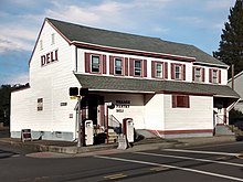
Grovers Mill is an unincorporated community located within West Windsor in Mercer County, in the U.S. state of New Jersey. It is centered around the intersection of Clarksville Road and Cranbury Road, adjacent to the community's mill-pond.
Assunpink Creek is a 22.9-mile-long (36.9 km) tributary of the Delaware River in western New Jersey in the United States. The name Assunpink is from the Lenape Ahsën'pink, meaning "stony, watery place".

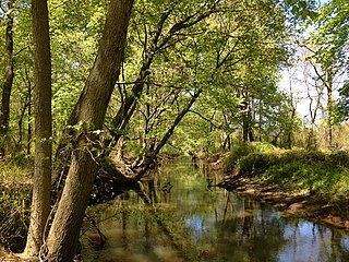
The Millstone River is a 38.6-mile-long (62.1 km) tributary of the Raritan River in central New Jersey in the United States.

County Route 579 is a county highway in the U.S. state of New Jersey. The highway extends 37.24 miles (59.93 km) from John Fitch Parkway in Trenton to Route 173 in Greenwich Township.

County Route 571 is a county highway in the U.S. state of New Jersey. The highway extends 43.96 miles (70.75 km) from Route 37 in Toms River Township to Route 27 in Princeton. Though it is designated a north–south county route by the New Jersey Department of Transportation (NJDOT), it is signed both as north–south and east–west inconsistently.

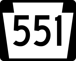
County Route 551 is a county highway in the U.S. state of New Jersey. The highway extends 34.57 miles (55.64 km) from Pennsville-Salem Road in Pennsville Township to Penn Street in Camden.

County Route 539 is a county highway in the U.S. state of New Jersey. The highway extends 54.32 miles (87.42 km) from Main Street in Tuckerton to CR 535 in Cranbury Township. Much of the two-lane route passes through isolated areas of the Pine Barrens and the eastern end of the Fort Dix entity of Joint Base McGuire–Dix–Lakehurst. In these stretches, the route has a speed limit of 55 miles per hour (89 km/h), one of the few two-lane roads in the state to carry a 55 mph limit. CR 539 passes through three boroughs: Tuckerton, Allentown, and Hightstown. Other than those boroughs, the route travels mainly through rural townships.

County Route 535 is a county highway in the U.S. state of New Jersey. The highway extends 32.31 miles (52.00 km) from Logan Avenue, at the boundary between Trenton and Hamilton Township in Mercer County to an interchange with U.S. Route 9 (US 9) and Route 35 in South Amboy, Middlesex County.
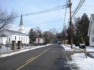
Dutch Neck is an unincorporated community located within West Windsor Township in Mercer County, in the U.S. state of New Jersey. The community is centered about the intersection of Village Road East, Village Road West, and South Mill Road and has in the vicinity several churches, the West Windsor Volunteer Fire Company No. 1, Dutch Neck Elementary School, and many residences.

County Route 526 is a county highway in the U.S. state of New Jersey. The highway extends 35.56 miles (57.23 km) from Princeton–Hightstown Road in West Windsor Township to Lanes Mill Road in Lakewood Township.

County Route 517 is a county highway in the U.S. state of New Jersey. The highway extends 53.86 miles (86.68 km) from Lamington Road in Tewksbury Township to the New York state line in Vernon Township where it continues as Orange County Route 26. It passes through mostly rural and exurban communities. Its speed limit varies from as much as 50 mph (80 km/h) to as little as 25 mph (40 km/h).
Pennsylvania Route 551 is a 34-mile-long (55 km) state highway located in Beaver, Lawrence, and Mercer counties in Pennsylvania. The southern terminus is at PA 18 in Beaver Falls. The northern terminus is at PA 18 near West Middlesex.

The William Trent House is a historic building located at 15 Market Street in Trenton, Mercer County, New Jersey. It was built in 1719 for William Trent and is the oldest building in Trenton. He founded the eponymous town, which became the capital of New Jersey. It has served as the residence for three Governors. The house was added to the National Register of Historic Places and listed as a National Historic Landmark on April 15, 1970, for its significance as an example of Early Georgian Colonial architecture.
The Assunpink Trail was a Native American trail in what later became Middlesex, Somerset, and Mercer counties in the central and western part of New Jersey. Like Assunpink Creek, the trail takes its name from the Algonquian language Ahsën'pink, meaning "stony, watery place".

The Shabakunk Creek is a tributary of the Assunpink Creek in Mercer County, New Jersey, United States. Via the Assunpink, its water ultimately flows into the Delaware River. The name Shabakunk is from the Lenape word meaning "shore land".

Penns Neck is an unincorporated community located within West Windsor Township in Mercer County, in the U.S. state of New Jersey. The community developed at the intersection of the Trenton-New Brunswick Turnpike and Washington Road. The Penns Neck Circle and the historic Penns Neck Baptist Church (1812) are both located in Penns Neck. The Princeton Branch rail line, known as the Dinky, has run through the area since 1865, and stopped at Penns Neck station until January 1971.

Cooleys Corner is an unincorporated community located within Upper Freehold Township in Monmouth County, in the U.S. state of New Jersey. The site of the settlement is within the Assunpink Wildlife Management Area, a New Jersey Department of Environmental Protection Division of Fish and Wildlife-operated preserved area in Monmouth and Mercer counties along the Assunpink Creek. Before the creation of the Assunpink Lake in the 1970s, the area consisted of farmland located at the intersection of Clarksburg Road and Imlaystown-Hightstown Road. Some farmland is still present in the area but is now mostly used by hunters. The main boat ramp to Assunpink Lake is located along the former Imlaystown-Hightstown Road.