Mercerville, New Jersey

Last updated

Mercerville, New Jersey
Mercerville, NJ - Five Points intersection.jpg
The Five Points intersection
Mercer County New Jersey incorporated and unincorporated areas Mercerville highlighted.svg
Location in Mercer County and the state of New Jersey.
USA New Jersey location map.svg
Red pog.svg
Mercerville, New Jersey
Usa edcp location map.svg
Red pog.svg
Mercerville, New Jersey
Coordinates: 40°14′09″N74°41′32″W / 40.235832°N 74.692254°W / 40.235832; -74.692254
Country Flag of the United States.svg  United States
State Flag of New Jersey.svg  New Jersey
County Mercer
Township Hamilton
Area
[1]
  Total3.72 sq mi (9.63 km2)
  Land3.69 sq mi (9.55 km2)
  Water0.03 sq mi (0.08 km2)  1.14%
Elevation
[2]
98 ft (30 m)
Population
 (2020) [3]
  Total13,447
  Density3,646.15/sq mi (1,407.73/km2)
Time zone UTC−05:00 (Eastern (EST))
  Summer (DST) UTC−04:00 (Eastern (EDT))
ZIP Code
08619 - Trenton [4]
FIPS code 3445480 [5] [6]
GNIS feature ID02389472 [5] [7]

Mercerville is an unincorporated community and census-designated place [8] (CDP) located within Hamilton Township, in Mercer County, in the U.S. state of New Jersey. [9] As of the 2010 United States Census, the CDP's population was 13,230. [10] Until after the 2000 census, the area was part of the Mercerville-Hamilton Square CDP. For the 2010 Census it was split into two CDPs, Mercerville and Hamilton Square. [11]

Contents

History

Map of the former Mercerville-Hamilton Square CDP in Mercer County (inset: Location of Mercer County in New Jersey) Mercerville hamilton square cdp nj 021.png
Map of the former Mercerville-Hamilton Square CDP in Mercer County (inset: Location of Mercer County in New Jersey)

Many historical markers in Mercerville detail the path of the Continental Army under the command of George Washington through the area during the American Revolutionary War. Several are related to their night march from the Second Battle of Trenton to the Battle of Princeton.

Originally called "Sandtown," Mercerville is named after General Hugh Mercer, who died on January 12, 1777, due to wounds incurred at the Battle of Princeton. Hamilton Square was renamed after Alexander Hamilton, during a wave of anti-British sentiment at the time of the War of 1812. It previously had been called Nottingham after the British town. [12]

Historic places

Geography

According to the United States Census Bureau, the CDP had a total area of 3.730 square miles (9.659 km2), including 3.687 square miles (9.549 km2) of land and 0.043 square miles (0.111 km2) of water (1.14%). [5] [13]

The main intersection in Mercerville is known as Five Points. It the junction of (starting north and heading clockwise): Quaker Bridge Road (County Route 533), Edinburg Road (CR 535), Nottingham Way (CR 618), White Horse-Mercerville Road (CR 533), and Nottingham Way (CR 535). In addition, New Jersey Route 33 runs east and west to the south of this intersection. Except for Notthingham Way east of Five Points, the preceding roads contain most of Mercervile's commercial businesses. [14]

Demographics

Historical population
CensusPop.Note
2020 13,447
U.S. Decennial Census [15] [3]

2010 census

The 2010 United States census counted 13,230 people, 5,028 households, and 3,605 families in the CDP. The population density was 3,588.5 per square mile (1,385.5/km2). There were 5,246 housing units at an average density of 1,422.9 per square mile (549.4/km2). The racial makeup was 88.81% (11,749) White, 3.98% (527) Black or African American, 0.22% (29) Native American, 3.67% (486) Asian, 0.04% (5) Pacific Islander, 1.90% (252) from other races, and 1.38% (182) from two or more races. Hispanic or Latino of any race were 6.86% (907) of the population. [10]

Of the 5,028 households, 28.9% had children under the age of 18; 57.8% were married couples living together; 10.1% had a female householder with no husband present and 28.3% were non-families. Of all households, 22.9% were made up of individuals and 11.2% had someone living alone who was 65 years of age or older. The average household size was 2.58 and the average family size was 3.06. [10]

20.7% of the population were under the age of 18, 7.0% from 18 to 24, 25.0% from 25 to 44, 29.6% from 45 to 64, and 17.7% who were 65 years of age or older. The median age was 43.1 years. For every 100 females, the population had 92.9 males. For every 100 females ages 18 and older there were 90.1 males. [10]

Education

Most high school students in Mercerville attend Nottingham High School.

Related Research Articles

<span class="mw-page-title-main">Mercer County, New Jersey</span> County in New Jersey, United States

Mercer County is a county located in the U.S. state of New Jersey. Its county seat is Trenton, also the state capital, prompting its nickname The Capital County. Mercer County alone constitutes the Trenton–Princeton metropolitan statistical area and is considered part of the New York combined statistical area by the U.S. Census Bureau, but also directly borders the Philadelphia metropolitan area and is included within the Federal Communications Commission's Philadelphia Designated Media Market Area.

<span class="mw-page-title-main">Hamilton Township, Mercer County, New Jersey</span> Township in Mercer County, New Jersey, United States

Hamilton Township is a township and the most populous municipality in Mercer County, in the U.S. state of New Jersey. It is the largest suburb of Trenton, the state's capital, which is located to the township's west. The township is situated within the New York metropolitan area as defined by the United States Census Bureau but directly borders the Philadelphia metropolitan area and is part of the Federal Communications Commission's Philadelphia Designated Market Area. As of the 2020 United States census, the township's population was 92,297, its highest decennial count ever and an increase of 3,833 (+4.3%) from the 2010 census count of 88,464, which in turn reflected an increase of 1,355 (+1.6%) from the 2000 census count of 87,109. The township was the state's ninth-largest municipality in 2010 and 2020, after having been ranked 10th in 2000.

<span class="mw-page-title-main">Mercerville-Hamilton Square, New Jersey</span> Former census-designated place in New Jersey, United States

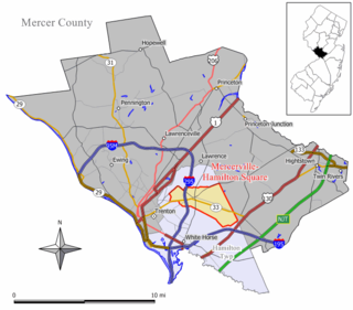
Mercerville-Hamilton Square is a census-designated place and unincorporated community located within Hamilton Township, in Mercer County, New Jersey, United States. As of the 2000 United States Census, the CDP's population was 26,419. As part of the 2010 Census, the area was split into two CDPs, Mercerville and Hamilton Square.

<span class="mw-page-title-main">Princeton Township, New Jersey</span> Township in New Jersey, United States

Princeton Township was a township in Mercer County, New Jersey, United States, that existed from 1838 until it was dissolved after it was merged with Princeton Borough in 2013 to form Princeton, New Jersey. As of the 2010 United States Census, the township's population was 16,265, reflecting an increase of 238 (+1.5%) from the 16,027 counted in the 2000 Census, which had in turn increased by 2,829 (+21.4%) from the 13,198 counted in the 1990 Census.

<span class="mw-page-title-main">Princeton North, New Jersey</span> Unincorporated community in New Jersey, United States

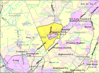
Princeton North, also known as North Princeton, is an unincorporated community that is located in Princeton, in Mercer County, New Jersey, United States. As of the 2000 Census, the CDP population was 4,528. While the area was categorized as a census-designated place in the 2000 Census, the CDP status was eliminated by the United States Census Bureau as of the 2010 Census. The community is located in what was formerly Princeton Township.

<span class="mw-page-title-main">Robbinsville Township, New Jersey</span> Township in Mercer County, New Jersey, United States

Robbinsville Township is a township in Mercer County, in the U.S. state of New Jersey. The township is part of the New York Metropolitan area as defined by the United States Census Bureau, but directly borders the Philadelphia metropolitan area and is part of the Federal Communications Commission's Philadelphia Designated Market Area. As of the 2020 United States census, the township's population was 15,476, its highest decennial count ever and an increase of 1,834 (+13.4%) from the 13,642 recorded at the 2010 census, which in turn reflected an increase of 3,367 (+32.8%) from the 10,275 counted in the 2000 census. The township is named for George R. Robbins, who served in the United States House of Representatives from 1855 to 1859 and lived in the area. Inspired by its central geographical location within New Jersey, Robbinsville's motto is Be at the Center of it All.

<span class="mw-page-title-main">West Windsor, New Jersey</span> Township in Mercer County, New Jersey, US

West Windsor is a township in Mercer County, in the U.S. state of New Jersey. Located within the Raritan Valley region, the township is an outer-ring suburb of New York City in the New York metropolitan area, as defined by the United States Census Bureau. As of the 2020 United States census, the township's population was 29,518, its highest decennial count ever and an increase of 2,353 (+8.7%) from the 27,165 recorded at the 2010 census, which in turn reflected an increase of 5,258 (+24.0%) from the 21,907 counted in the 2000 census.

<span class="mw-page-title-main">White Horse, New Jersey</span> Census-designated place in New Jersey, United States

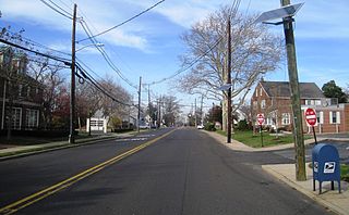
White Horse is an unincorporated community and census-designated place (CDP) located within Hamilton Township, in Mercer County, New Jersey, United States. As of the 2010 United States Census, the CDP's population was 9,494.

<span class="mw-page-title-main">Yardville-Groveville, New Jersey</span> Former CDP in New Jersey, United States

Yardville-Groveville was an unincorporated community and census-designated place (CDP) located within Hamilton Township, in Mercer County, New Jersey, United States. As of the 2000 United States Census, the CDP's population was 9,208.

<span class="mw-page-title-main">County Route 533 (New Jersey)</span>

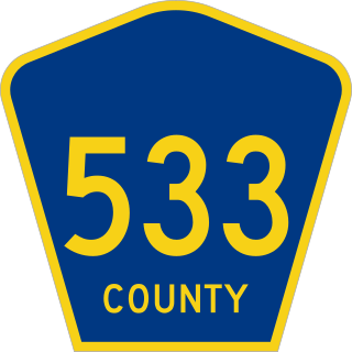
County Route 533 is a county highway in the U.S. state of New Jersey. The highway extends 32.78 miles (52.75 km) from the White Horse Circle, in Hamilton Township to Middlesex CR 607 on the border of Bound Brook and Middlesex Borough. CR 533 shares a long concurrency with U.S. Route 206 through Princeton and Montgomery Township, while portions of the roadway in Somerset County are part of the Millstone River Valley Scenic Byway.

Columbia is an unincorporated community and census-designated place (CDP) located within Knowlton Township in Warren County, in the U.S. state of New Jersey. While the community has existed for over a century, the CDP was created as part of the 2010 United States Census. As of the 2010 Census, the CDP's population was 229. The area is served as United States Postal Service ZIP Code 07832.

<span class="mw-page-title-main">Robbinsville (CDP), New Jersey</span> Census-designated place in New Jersey, United States

Robbinsville is a census-designated place (CDP) located within Robbinsville Township in Mercer County, New Jersey, United States. The area is served as United States Postal Service ZIP Code 08691. As of the 2010 United States Census, the population for the CDP was 3,041.

<span class="mw-page-title-main">Windsor, New Jersey</span> Populated place in Mercer County, New Jersey, US

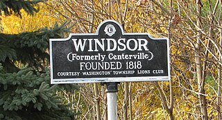
Windsor is a small historic unincorporated community and census-designated place (CDP) located within Robbinsville Township in Mercer County, in the U.S. state of New Jersey. The area is served as United States Postal Service ZIP Code 08561. As of the 2020 United States census, the CDP's population was 330, an increase of 104 (+46.0%) above the 226 counted at the 2010 census. The community, covering 570 acres (230 ha), was added to the National Register of Historic Places in 1992.

<span class="mw-page-title-main">Yardville, New Jersey</span> Census-designated place in New Jersey, United States

Yardville is an unincorporated community and census-designated place (CDP) located within Hamilton Township, in Mercer County, New Jersey, United States. As of the 2010 United States Census, the CDP's population was 2,945. Before the 2010 Census, the area was part of the Yardville-Groveville CDP.

<span class="mw-page-title-main">Groveville, New Jersey</span> Census-designated place in New Jersey, United States

Groveville is an unincorporated community and census-designated place (CDP) located within Hamilton Township, in Mercer County, in the U.S. state of New Jersey. As of the 2010 United States Census, the CDP's population was 2,945. Before the 2010 Census, the area was part of the Yardville-Groville CDP.

<span class="mw-page-title-main">Hamilton Square, New Jersey</span> Census-designated place in New Jersey, United States

Hamilton Square is an unincorporated community and census-designated place (CDP) located within Hamilton Township, in Mercer County, in the U.S. state of New Jersey, that is the site of a historic colonial village. Until the 2000 census the area was part of the Mercerville-Hamilton Square CDP, which was split into two CDPs as of 2010: Mercerville and Hamilton Square. As of the 2010 United States Census, the CDP's population was 12,784.

Upper Stewartsville is an unincorporated community and census-designated place (CDP) located within Greenwich Township in Warren County, New Jersey, United States, that was defined as part of the 2010 United States Census. As of the 2010 Census, the CDP's population was 212.

Silver Lake is an unincorporated community and census-designated place (CDP) located within Hope Township in Warren County, New Jersey, United States, that was defined as part of the 2010 United States Census. As of the 2010 Census, the CDP's population was 368.

Mountain Lake is an unincorporated community and census-designated place (CDP) located within Liberty Township in Warren County, in the U.S. state of New Jersey, that was created as part of the 2010 United States Census. As of the 2020 United States census, the CDP's population was 494 a decrease of 81 (−14.1%) from the 575 recorded at the 2010 census.

Upper Pohatcong is an unincorporated community and census-designated place (CDP) located within Pohatcong Township in Warren County, New Jersey, United States, that was defined as part of the 2010 United States Census. As of the 2010 Census, the CDP's population was 1,781.

References

  1. "ArcGIS REST Services Directory". United States Census Bureau. Retrieved October 11, 2022.
  2. U.S. Geological Survey Geographic Names Information System: Mercerville Census Designated Place, Geographic Names Information System. Accessed November 21, 2012.
  3. 1 2 "Census Population API". United States Census Bureau. Retrieved October 11, 2022.
  4. Look Up a ZIP Code for Mercerville, NJ, United States Postal Service. Accessed November 21, 2012.
  5. 1 2 3 Gazetteer of New Jersey Places, United States Census Bureau. Accessed July 21, 2016.
  6. U.S. Census website, United States Census Bureau. Accessed September 4, 2014.
  7. US Board on Geographic Names, United States Geological Survey. Accessed September 4, 2014.
  8. of New Jersey Census Designated Places - BVP20 - Data as of January 1, 2020, United States Census Bureau. Accessed January 1, 2023.
  9. Locality Search, State of New Jersey. Accessed April 19, 2015.
  10. 1 2 3 4 DP-1 - Profile of General Population and Housing Characteristics: 2010 Demographic Profile Data for Mercerville CDP, New Jersey, United States Census Bureau. Accessed November 21, 2012.
  11. New Jersey: 2010 - Population and Housing Unit Counts - 2010 Census of Population and Housing (CPH-2-32), P. III-4. United States Census Bureau, August 2012. Accessed November 20, 2012. "Mercer County—Name Changes: Robbinsville township name changed from Washington; New CDPs: Groveville (formed from part of deleted Yardville-Groveville CDP and additional area), Hamilton Square (formed from part of deleted Mercerville-Hamilton Square CDP and additional area), Mercerville (formed from part of deleted Mercerville-Hamilton Square CDP), Robbinsville, and Yardville (formed from part of deleted Yardville-Groveville CDP and additional area)"
  12. History of Hamilton Township, Hamilton Township Historical Society, 1999.
  13. US Gazetteer files: 2010, 2000, and 1990, United States Census Bureau. Accessed September 4, 2014.
  14. Google (September 12, 2015). "Aerial view of Mercerville" (Map). Google Maps . Google. Retrieved September 12, 2015.
  15. "Census of Population and Housing". Census.gov. Retrieved June 4, 2016.