
San Jacinto Peak is a 10,834 ft (3,302 m) peak in the San Jacinto Mountains, in Riverside County, California. Lying within Mount San Jacinto State Park it is the highest both in the range and the county, and serves as the southern border of the San Gorgonio Pass. Naturalist John Muir wrote of San Jacinto Peak, "The view from San Jacinto is the most sublime spectacle to be found anywhere on this earth!"

The Angeles National Forest (ANF) of the U.S. Forest Service is located in the San Gabriel Mountains and Sierra Pelona Mountains, primarily within Los Angeles County in southern California. The ANF manages a majority of the San Gabriel Mountains National Monument.

Mount Humphreys is a mountain peak in the Sierra Nevada on the Fresno-Inyo county line in the U.S. state of California. It is the 13th highest peak in California, and the highest peak in the Bishop area. The mountain was named by the California Geological Survey of 1873 for Andrew A. Humphreys, the chief engineer of the United States Army at the time.

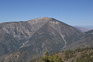
Mount San Antonio, commonly referred to as Mount Baldy or Old Baldy, is a 10,064 ft (3,068 m) summit in the San Gabriel Mountains on the border of Los Angeles and San Bernardino counties of California. Lying within the San Gabriel Mountains National Monument and Angeles National Forest, it is the high point of the range, the County of Los Angeles, and the Los Angeles metropolitan area.

Cucamonga Peak is one of the highest peaks of the San Gabriel Mountains in San Bernardino County, California, with a summit elevation of 8,862 feet (2,701 m). It is within the Cucamonga Wilderness of the San Bernardino National Forest.

Mount Williamson, at an elevation of 14,379 feet (4,383 m), is the second-highest mountain in both the Sierra Nevada range and the state of California, and the sixth-highest peak in the contiguous United States.
Mount Baden-Powell is a peak in the San Gabriel Mountains of California named for the founder of the World Scouting Movement, Robert Baden-Powell, 1st Baron Baden-Powell. It was officially recognized by the USGS at a dedication ceremony in 1931. It was originally known as East Twin or North Baldy.
Waterman Mountain, at 8,041 feet (2,451 m), is a prominent peak in the San Gabriel Mountains of Los Angeles County, California, within the Angeles National Forest and San Gabriel Mountains National Monument.

Split Mountain is a fourteener in the Sierra Nevada of the U.S. state of California, near the southeast end of the Palisades group of peaks. It is the only fourteener in the watershed of the South Fork Kings River, and rises to 14,064 ft (4,287 m), making it the eighth-highest peak in the state.
Frazier Mountain is a broad, pine-forested peak in the Transverse Ranges System, within the Los Padres National Forest in northeastern Ventura County, California. At 8,017 feet (2,444 m), Frazier Mnt. is the sixteenth-highest mountain in the Transverse Ranges of Southern California.

Mount Tallac is a mountain peak southwest of Lake Tahoe, in El Dorado County, California. The peak lies within the Desolation Wilderness in the Eldorado National Forest. It is quite visible from State Routes 89 and 28, and U.S. Route 50. A "cross of snow" is clearly visible on the mountain's face during the winter, spring, and early summer months.

San Gabriel Peak is a summit in the San Gabriel Mountains in the U.S. state of California. It was named by the United States Geological Survey in 1894 and is located in the Angeles National Forest. This peak was first named The Commodore for Commodore Perry Switzer.

Mount Harwood is the first summit east of Mount San Antonio. The United States Geological Survey recognized the name to honor California educator and conservationist Aurelia Squire Harwood in 1965. Prior to this, the peak now known as Thunder Mountain was also referred to as Mount Harwood. Mount Harwood is located on the East side of the San Gabriel Mountains in the Angeles National Forest near the San Bernardino-Los Angeles county border. In this area of the San Gabriel Mountains the peaks are the highest. Because of the elevation Mount Harwood turns out to be ranked the 4th highest peak in the San Gabriel mountains after Dawson Peak, Mount San Antonio or "Old Baldy" being the highest at 10,064 feet. The only way for hikers or tourists to access Mount Harwood is to take Mt. Baldy Road off I-210. A National Forest Adventure pass/ National Park access pass must be displayed on a vehicle to access Mount Harwood.

Telegraph Peak, is a peak of the San Gabriel Mountains, in the San Gabriel Mountains National Monument and San Bernardino County, California.
Anderson Peak is a mountain on the Mount San Gorgonio crestline in Southern California's San Gorgonio Wilderness, which is part of the San Bernardino National Forest. It is 3.2 miles (5.1 km) from Jepson Peak. Although not above the tree line, snow tends to cover the crest from the northern hemisphere early winter until late spring.
Big Pine Mountain is a mountain located in the San Rafael Mountains of the California Transverse Ranges. High enough to receive snowfall during the winter, The summit, at 6800+ feet (2,074+ m), is the highest point in the San Rafael Mountains, the Dick Smith Wilderness, and Santa Barbara County. The peak and the surrounding area were severely impacked by the Zaca fire in 2007.
Ontario Peak is a 8,696 ft (2,651 m) high peak in the San Gabriel Mountains of California. Like its neighbor Cucamonga Peak, it is in the San Bernardino National Forest, and in the Cucamonga Wilderness. The peak is named for the nearby city of Ontario, about 12 mi (19 km) due south, and first appeared in the General Land Office Forest Atlas in 1908.

Mount Mallory is a mountain located in the Sierra Nevada of California. The boundary between Inyo National Forest and Sequoia National Park runs across the summit. The peak was named in memory of George H. Leigh Mallory, of the 1924 British Mount Everest expedition, who was lost on Mount Everest, June, 1924. Norman Clyde advanced Mallory's and Andrew Irvine's names following their loss after attaining the highest altitude reached by a mountain climber.

Throop Peak is a 9,142 feet (2,786 m) peak of the San Gabriel Mountains, in the San Gabriel Mountains National Monument and Angeles National Forest, in Los Angeles County, California.

Mount Lukens is a mountain peak of the San Gabriel Mountains, in Los Angeles County, Southern California. It is the highest point in the city of Los Angeles.

