Tobati people

Last updated
Tobati
Tobati-Enggros
Youtefa Tobati
Total population
100 [1]
Regions with significant populations
Papua (Jayapura)
Languages
Tobati, Papuan Malay, and Indonesian
Religion
Christianity, Islam [1]
Related ethnic groups
Enggros   Nafri   Sentani

The Tobati People (also known as Tobati-Enggros; also referred to as Youtefa Tobati) are an ethnic group from Jayapura, Indonesia. [2] The Tobati people inhabit the coastal area of Youtefa Bay, covering an area of 1,675 hectares within the South Jayapura district, and they have constructed settlements above the sea. [3]

Contents

Etymology

The word Tobati has the same origin as Tabi, which means "sunrise." This village is believed to have been founded by the 'siblings of the sun,' hence named Tabati, which later became Tobati. [4] According to another source, the name Tobati comes from to, meaning Sultan's command, and "bati," means boundary, indicating the Sultan of Tidore boundary reached Tobati Island. [5]

History

The Tobati people are the original inhabitants of Jayapura. This tribe is also known as the Tobati-Enggros tribe. However, Enggros is occasionally considered a separate tribe but still closely related to Tobati. [6] Apart from the Tobati tribe, there are also other indigenous tribes in Jayapura City, such as the Kayu Pulau, Kayu Batu, Nafri, Skouw, and Sentani tribes. [7]

Not far from the center of Jayapura city, about 20 minutes towards Abepura district, there is a bay called Youtefa Bay. In the bay, there are two traditional villages of the Tobati tribe, Tobati and Enggros, which have long inhabited the area. [6]

Customs

Leadership system

The Tobati, like other tribes in Youtefa Bay, has a traditional political leadership system led by an ondoafi (village leader or chief), and the position has been inherited through generations. When the evangelist Built began serving in the Tobati area, Tobati was led by a tribal chief named Jantewai. When Jantewai passed away, his son Hamadi was appointed as the ondoafi. To this day, the Hamadi clan still holds the position of ondoafi of the Tobati tribe that leads several other tribal chiefs/clans such as Itaar, Afaar, Hanasbey, Mano, Ireeuw, Hasor, Merauje, Merahabia, Caay, Hanoeby, and Dawir. [4]

Marriage

During the marriage procession, the Tobati people must undergo 7 customary processes before officially becoming a family. The first process begins with the groom's side, which is the proposal process. The groom's family will go to the bride's house to seek permission to propose to the bride. After that, in the second process, the bride's side will reciprocate the visit by sending food to the groom's house. The third process is where the groom's side will gather a certain amount of dowry as agreed upon. In the fourth process, still from the groom's side, the dowry will be directly delivered to the bride's side. Then, in the fifth process, both sides are ready to conduct the holy wedding blessing in the church and simultaneously register the marriage at the Civil Registry Office. After that, the sixth process is where the bride will be escorted to the groom's house. The last process is to deliver various kitchen utensils from the bride's side to the groom's house. All processes have been completed and will be concluded by signing the dowry acceptance agreement from the groom's side to the bride's side, which will end with a feast or meal together. [8]

Architecture

Sway

Tobatis' daily dwelling place is called a sway house. The sway house is almost similar to the traditional kariwari house, with differences in the allocation or function of its rooms. This is done as a development of the traditional house form so that the traditional house and the living house can be distinguished while still remaining a characteristic building of the Tobati tribe. The allocation of each room in the sway house consists of a living room, bedroom, and dining room. [3]

The layout of sway house buildings is constructed on the edge or at the side of the main village road, and the orientation of the buildings is directed towards the main road so that the houses face each other. In more detail, the layout of rooms within the sway consists of bedrooms, a living room, a kitchen area (often referred to as the working area for women), and a back terrace. [3]

As for the interior of the house, the rooms are divided based on gender. The area for men is positioned towards the sea, while the area for women is inclined towards the land. [3]

Kariwari

Kariwari in Taman Mini Indonesia Indah Raiyani Muharramah Rumah Karwari Papua DSC 8244.jpg
Kariwari in Taman Mini Indonesia Indah

The traditional house of the Tobati is called kariwari or mau house. This traditional house, which is 20–30 meters high, is for males aged 12 and above. It serves as a place for traditional ceremonies and also educates young boys on how to earn a living and survive by learning skills such as carving, weapon-making, boatbuilding, and warfare techniques. [9]

The shape of this building itself is square or octagonal, resembling a cone, with its division consisting of 3 main floors: the foot part (floor 1), the body part (floor 2), and the head part (floor 3). The first floor is used as a place to educate young boys. The second floor is the tribal chief's room, meeting room, and resting place for males. Meanwhile, the third floor is used as a prayer area. [9]

The octagonal shape of this building is constructed so that it can withstand strong wind. According to Tobati tradition, the conical roof allows them to be closer to their ancestors. The floor is made of layers of wood bark, while the building walls are made of bamboo tree shards, and the roof is made from sago leaves. [9]

Keramba

Tobati people fishing from a boat in 1903 Fishing Papuans from Tobati in proas - Collectie stichting Nationaal Museum van Wereldculturen - TM-10009793.jpg
Tobati people fishing from a boat in 1903

The settlement of the Tobati tribe is located directly in coastal or marine areas. Therefore, fishing is one of their main activities, especially for men. Building kelong (floating fish pens) is a mandatory activity for them. The characteristic feature of the Tobati's kelong is that it is made from bamboo poles. These kelongs are usually placed beneath the houses, with nets surrounding each house pole. [3]

Giant trevally and rabbitfish are two fishes most commonly cultivated by the Tobati people. In addition to catching fish, kelongs are also used to hold various small fish to attract larger fish into the nets set up around the bottom of the house. [3]

Religion

Before the introduction of Christianity and Islam in Jayapura, the Tobati tribe still adhered to animism or belief in ancestors. The evidence of this can be seen in the Kariwari house buildings. The conical or pyramid-shaped roof is interpreted by the Tobati as a form of respect for their ancestors and to bring them closer to God. [3] At that time, The Tobati community also communicated with the Sultanate of Tidore, which later spread Islam through Muhammad Asghar, a scholar from Baghdad sent by the Ottoman Empire. Because of this, there are many historical remnants of Islam, such as mosques, some of which have been turned into museums in South Jayapura. [10]

Since the arrival of European missionaries, especially the Dutch, in 1910, Christianity has had a greater influence on the Tobati people's beliefs than the influence of the Sultanate of Tidore. The Gospel was spread in Papua, including the Tobati and Enggros villages, and the teachings of Christianity were subsequently accepted by the surrounding communities. Eventually, the Tobati people adhered to Christianity. [11] Since the arrival of the Dutch, the mau houses were considered idols and inconsistent with Christian teachings, so the mau houses were destroyed, leaving poles the only remnants that can still be seen today. [10]

Transportation system

The Tobati tribe is a community inhabiting coastal areas, hence their main mode of transportation is boats. The local inhabitants call it wah, which means "boat." The people in Tobati village and Enggros village use wah as a means of public transportation and also for fishing. Initially, rowing was used to operate the wah, but nowadays, automatic engines have been used at wah to facilitate travel. Previously, traveling to a certain place took about 30 minutes, but now, with engines, the journey only takes around 4 minutes. [12]

Related Research Articles

<span class="mw-page-title-main">Papua (province)</span> Province of Indonesia

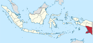
Papua is a province of Indonesia, comprising the northern coast of Western New Guinea together with island groups in Cenderawasih Bay to the west. It roughly follows the borders of Papuan customary region of Tabi Saireri. It is bordered by the sovereign state of Papua New Guinea to the east, the Pacific Ocean to the north, Cenderawasih Bay to the west, and the provinces of Central Papua and Highland Papua to the south. The province also shares maritime boundaries with Palau in the Pacific. Following the splitting off of twenty regencies to create the three new provinces of Central Papua, Highland Papua, and South Papua on 30 June 2022, the residual province is divided into eight regencies and one city (kota), the latter being the provincial capital of Jayapura. The province has a large potential in natural resources, such as gold, nickel, petroleum, etc. Papua, along with five other Papuan provinces, has a higher degree of autonomy level compared to other Indonesian provinces.

<span class="mw-page-title-main">Jayapura</span> Capital and largest city of Papua, Indonesia

Jayapura is the capital and largest city of the Indonesian province of Papua. It is situated on the northern coast of New Guinea island and covers an area of 940.0 km2 (362.9 sq mi). The city borders the Pacific Ocean and Yos Sudarso Bay to the north, the country of Papua New Guinea to the east, Keerom Regency to the south, and Jayapura Regency to the west.

<span class="mw-page-title-main">West Papua (province)</span> Province in Indonesia

West Papua, formerly Irian Jaya Barat, is an Indonesian province located in the land of Papua. It covers most of the two western peninsulas of the island of New Guinea, the eastern half of the Bird's Head Peninsula and the whole of the Bomberai Peninsula, along with nearby smaller islands. The province is bordered to the north by the Pacific Ocean, to the west by Southwest Papua Province, the Halmahera Sea and the Ceram Sea, to the south by the Banda Sea, and to the east by the province of Central Papua and the Cenderawasih Bay. Manokwari is the province's capital and largest city. With an estimated population of 561,403 in mid-2022, West Papua is the least populous province in Indonesia after Southwest Papua, which was a part of West Papua until separated off in 2022.

<span class="mw-page-title-main">Indigenous people of New Guinea</span> Melanesian inhabitants of New Guinea

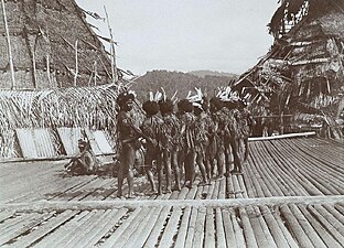
The indigenous peoples of Western New Guinea in Indonesia and Papua New Guinea, commonly called Papuans, are Melanesians. There is genetic evidence for two major historical lineages in New Guinea and neighboring islands: a first wave from the Malay Archipelago perhaps 50,000 years ago when New Guinea and Australia were a single landmass called Sahul and, much later, a wave of Austronesian people from the north who introduced Austronesian languages and pigs about 3,500 years ago. They also left a small but significant genetic trace in many coastal Papuan peoples.

<span class="mw-page-title-main">Western New Guinea</span> Region of Indonesia on the island of New Guinea

Western New Guinea, also known as Papua, Indonesian New Guinea, and Indonesian Papua, is the western half of the island of New Guinea granted to Indonesia in 1962. Given the island is alternatively named Papua, the region is also called West Papua.

<span class="mw-page-title-main">Cirebonese people</span> Ethnic group in Indonesia

The Cirebon or Cirebonese are an indigenous ethnic group native to Cirebon in the northeastern region of West Java, Indonesia. With a population of approximately 1.9 million, the Cirebonese population, they are mainly adherents of Sunni Islam. Their native language is the Cirebonese, which is a form of mixed language between the Javanese and Sundanese, with a heavier influence from Javanese.

<span class="mw-page-title-main">Raja Ampat Islands</span> Archipelago in Southwest Papua, Indonesia

Raja Ampat, or the Four Kings, is an archipelago located off of the northwest tip of Bird's Head Peninsula, Southwest Papua province, Indonesia. It comprises over 1,500 small islands, cays, and shoals around the four main islands of Misool, Salawati, Batanta, and Waigeo, and the smaller island of Kofiau.

<span class="mw-page-title-main">Dortheys Hiyo Eluay International Airport</span> Airport in Papua, Indonesia

Dortheys Hiyo Eluay International Airport, also known as Sentani International Airport is an airport serving Jayapura, the capital of Papua province, Indonesia, on the island of New Guinea. It is located in the Sentani District, approximately 40 km from downtown Jayapura; the name 'Sentani' is taken from Lake Sentani nearby. It is the easternmost airport in Indonesia, the main hub, and the largest airport on the island of New Guinea. On 14 October 2019, the management of the airport was taken over by PT Angkasa Pura I (Persero).

Bomberai Peninsula is located in the Western New Guinea region. It is south of the Bird's Head Peninsula, and Bintuni Bay separates the two peninsulas. To the west lies the Sebakor Bay and to the south Kamrau Bay. On the southeast Arguni Bay lies between the peninsula and the Bird's Neck Isthmus.

Ambai are the archipelago or the chain of islands off the southern coast of Yapen Island, in Cenderawasih Bay and Papua Province in Western New Guinea, northeastern Indonesia.

<span class="mw-page-title-main">New Guinea</span> Island in the Pacific Ocean

New Guinea is the world's second-largest island, with an area of 785,753 km2 (303,381 sq mi). Located in Melanesia in the southwestern Pacific Ocean, the island is separated from Australia by the 150-kilometre wide Torres Strait, though both landmasses lie on the same continental shelf, and were united during episodes of low sea level in the Pleistocene glaciations as the combined landmass of Sahul. Numerous smaller islands are located to the west and east. The island's name was given by Spanish explorer Yñigo Ortiz de Retez during his maritime expedition of 1545 due to the resemblance of the indigenous peoples of the island to those in the African region of Guinea.

<span class="mw-page-title-main">Sultanate of Tidore</span> Sultanate in Southeast Asia

The Sultanate of Tidore was a sultanate in Southeast Asia, centered on Tidore in the Maluku Islands. It was also known as Duko, its ruler carrying the title Kië ma-kolano. Tidore was a rival of the Sultanate of Ternate for control of the spice trade and had an important historical role as binding the archipelagic civilizations of Indonesia to the Papuan world. According to extant historical records, in particular the genealogies of the kings of Ternate and Tidore, the inaugural Tidorese king was Sahjati or Muhammad Naqil whose enthronement is dated 1081 in local tradition. However, the accuracy of the tradition that Tidore emerged as a polity as early as the 11th century is considered debatable. Islam was only made the official state religion in the late 15th century through the ninth King of Tidore, Sultan Jamaluddin. He was influenced by the preachings of Syekh Mansur, originally from Arabia. In the 16th and 17th centuries, the Sultans tended to ally with either Spain or Portugal to maintain their political role but were finally drawn into the Dutch sphere of power in 1663. Despite a period of anti-colonial rebellion in 1780–1810, the Dutch grip on the sultanate increased until decolonization in the 1940s. Meanwhile, Tidore's suzerainty over Raja Ampat and western Papua was acknowledged by the colonial state. In modern times, the sultanate has been revived as a cultural institution.

<span class="mw-page-title-main">Rumah adat</span> Traditional Indonesian houses

Rumah adat are traditional houses built in any of the vernacular architecture styles of Indonesia, collectively belonging to the Austronesian architecture. The traditional houses and settlements of the several hundreds ethnic groups of Indonesia are extremely varied and all have their own specific history. It is the Indonesian variants of the whole Austronesian architecture found all over places where Austronesian people inhabited from the Pacific to Madagascar each having their own history, culture and style.

<span class="mw-page-title-main">Lake Sentani</span> Lake in Papua, Indonesia

Lake Sentani is a tropical, shallow, and at low-altitude open lake located at the northeast extremity of the Jayapura Regency in the Indonesian province of Papua, about 20 kilometres (12 mi) from the provincial capital, Jayapura City. It is located just to the south of the town of Sentani.

<span class="mw-page-title-main">South Papua</span> Province of Indonesia

South Papua, officially the South Papua Province, is an Indonesian province located in the southern portion of Papua, following the borders of the Papuan customary region of Anim Ha. Formally established on 11 November 2022 and including the four most southern regencies that were previously part of the province of Papua and before 11 December 2002 had comprised a larger Merauke Regency, it covers a land area of 117,849.16 km2, about the same area as Pennsylvania. This area had a population of 513,617 at the 2020 Census, while the official estimate as at mid 2023 was 534,416, making it the least populous province in Indonesia.

Lembak people, also known as Linggau people, are a local ethnic group that inhabits several areas of Bengkulu Province and South Sumatra Province in Indonesia. Their original settlements are in the border area between the two provinces, in the Barisan mountain range, with densely clustered villages pattern.

<span class="mw-page-title-main">Ramses Ohee</span> Indonesian pharmacist and politician (1931–2022)

Ramses Ohee was a Papuan-Indonesian pharmacist and politician who served as a member of the Jayapura Regional People's Representative Council from 1992 to 1999, and as an appointed member of the Papuan People's Representative Council from 2017 to 2019, and from 2021 until his death. Previously, he worked as an advisor to the government of Netherlands New Guinea and as a pharmacist in the health service of Netherlands New Guinea and the West Irian province.

<span class="mw-page-title-main">Central Papua</span> Province in Indonesia

Central Papua, officially the Central Papua Province is an Indonesian province located in the central region of Western New Guinea. It was formally established on 11 November 2022 from the former eight western regencies of the province of Papua. It covers an area of 61,072.92 km2 and had an officially estimated population of 1,430,951 in mid 2022. It is bordered by the Indonesian provinces of West Papua to the west, the residual province of Papua to the north and northeast, by Highland Papua to the east. and by South Papua to the southeast. The administrative capital is located in Wanggar District in Nabire Regency, although Timika is a larger town.

<span class="mw-page-title-main">Highland Papua</span> Province with special status

Highland Papua is a province of Indonesia, which roughly follows the borders of Papuan customary region of Lano-Pago, shortened to La Pago. It covers an area of 51,213.34 km2 (19,773.58 sq mi) and had a population of 1,430,459 according to the official estimates as at mid 2022.

<span class="mw-page-title-main">Southwest Papua</span> Province with special status

Southwest Papua is the 38th province of Indonesia to be created, and was split off from West Papua on 8 December 2022. Despite being named southwest, it is a misnomer and this province is actually located in the northwest edge of Papua. The province comprises the Greater Sorong area which consists of Sorong City, Sorong Regency, South Sorong Regency, Maybrat Regency, Tambrauw Regency, and Raja Ampat Regency. The Bill (RUU) on the Establishment of the Southwest Papua Province was passed into law and therefore it became the 38th province in Indonesia.

References

  1. 1 2 "Yotafa, Tobati People in Indonesia". joshuaproject.net. Joshua Project. Retrieved 3 April 2019.
  2. "Sekilas Papua". www.papua.go.id. Retrieved 2 April 2019.
  3. 1 2 3 4 5 6 7 "Arsitektur Tradisional Suku Tobati". www.sastrapapua.com. Retrieved 4 April 2019.
  4. 1 2 Marthen, Fadly (2012). Melihat Klaim dan Sengketa Tanah pada Orang Kayu Batu dan Kayu Pulo di Kota Jayapura (PDF) (Thesis) (in Indonesian). Universitas Indonesia. Retrieved 2023-06-24.
  5. Wanggai, Tony V. M. (2008). Rekonstruksi Sejarah Islam di Tanah Papua (PDF) (Thesis) (in Indonesian). UIN Syarif Hidayatullah. Retrieved 2022-01-30.
  6. 1 2 "Menelusuri Asal Usul Penduduk Jayapura di Kampung Enggros dan Pulau Debi". www.indonesiakaya.com. Retrieved 4 April 2019.
  7. "Suku Bangsa (Etnis) dan Bahasa di Kota Jayapura". www.papua.go.id. Retrieved 4 April 2019.
  8. "Nilai-nilai Kearifan Lokal Suku Besar Enggros, Tobati, Terus Dijaga dan Dilestarikan". www.youtefapost.com. Archived from the original on 2019-04-03. Retrieved 4 April 2019.
  9. 1 2 3 "Rumah Adat Papua Kariwari". www.romadecade.com. Archived from the original on 2019-03-31. Retrieved 4 April 2019.
  10. 1 2 "Eksotisme Jayapura Dengan Pemandangan Laut Memikat". www.pesona.travel.com. Archived from the original on 2019-04-04. Retrieved 4 April 2019.
  11. "Eksotisme Jayapura Dengan Pemandangan Laut Memikat - Pesona Indonesia". web.archive.org. 2019-04-04. Retrieved 2024-04-04.
  12. "Wah, Transportasi Tradisional Warga Tobati dan Enggros". www.kabarpapua.co. Retrieved 4 April 2019.