Related Research Articles

The Bismarck Archipelago is a group of islands off the northeastern coast of New Guinea in the western Pacific Ocean and is part of the Islands Region of Papua New Guinea. Its area is about 50,000 square km.

New Ireland Province, formerly New Mecklenburg, and Nova Hibernia, is the northeasternmost province of Papua New Guinea.
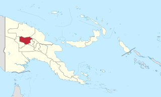
Enga is one of the provinces in Papua New Guinea (PNG). Enga is geographically situated in the northern region of Papua New Guinea and was separated from the adjacent Western Highlands at the time of national independence in 1975. The majority ethnic group are Engans. Approximately 500,000 people live within the province, which has one spoken language in all five of its districts. A small minority of Engans' land on the eastern side of the region remained in the Western Highlands, their territory being accessible by road from Mount Hagen but not directly from elsewhere in Enga territory.

West New Britain is a province of Papua New Guinea on the islands of New Britain. The provincial capital is Kimbe. The area of the province is 20,387 km2 with a population of 264,264 as of the 2011 census. The province's only land border is with East New Britain. There are seven major tribes, the Nakanai, Bakovi, Kove, Unea, Maleu, Arowe, speaking about 25 languages.
The Tolai are the indigenous people of the Gazelle Peninsula and the Duke of York Islands of East New Britain in the New Guinea Islands region of Papua New Guinea. They are ethnically close kin to the peoples of adjacent New Ireland and tribes like the Tanga people and are thought to have migrated to the Gazelle Peninsula in relatively recent times, displacing the Baining people who were driven westwards.

The Eastern Trans-Fly languages are a small independent family of Papuan languages spoken in the Oriomo Plateau to the west of the Fly River in New Guinea.
The Yuat languages are an independent family of five Papuan languages spoken along the Yuat River in East Sepik Province, Papua New Guinea. They are an independent family in the classification of Malcolm Ross, but are included in Stephen Wurm's Sepik–Ramu proposal. However, Foley and Ross could find no lexical or morphological evidence that they are related to the Sepik or Ramu languages.
The Ata language, also known as Pele-Ata after its two dialects, or Wasi, is a Papuan language spoken on New Britain island, Papua New Guinea. It appears to be related to neighboring Anêm, and possibly also to Yélî Dnye in a proposed Yele-West New Britain family. There are about 2000 speakers.
The Star Mountains are a mountain range in western Papua New Guinea and the eastern end of Highland Papua, Indonesia, stretching from the eastern end of Indonesia to the Hindenburg Range in Papua New Guinea.
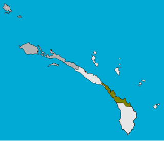
The Tanga Islands are an island group in Papua New Guinea, located north-east of New Ireland and part of the Bismarck Archipelago. Tanga is made up of four main islands — Boang, Maledok, Lif and Tefa — and a number of smaller, uninhabited islands. Boang consists entirely of a raised, relatively flat-topped plateau of Pleistocene, coralline limestone, which rises up to 170 m above sea level (asl.) and has sheer cliffs around a large part of its perimeter. The islands are the remnants of a stratovolcano which collapsed to form a caldera. Lif (283 m), Tefa (155 m), and Malendok (472 m) islands are on the caldera rim, while Bitlik and Bitbok islands are lava domes constructed near the center of the caldera.

Namatanai District is the southernmost and larger of the two districts of New Ireland Province in Papua New Guinea. The district covers the southern part of the island of New Ireland, as well as the Tabar Group, the Lihir Group, the Tanga Islands and the Feni Islands.
Namatanai Rural LLG is a local government area in New Ireland Province, Papua New Guinea. The LLG is located in Namatanai District and the LLG headquarters is Namatanai.

Tanir Rural LLG is a local government area in New Ireland Province, Papua New Guinea since 2008. The LLG administers the Tanga Islands and the Feni Islands. Tanir is a portmanteau word from the two island names which are Tanga and Anir.

The continent of Australia, sometimes known in technical contexts by the names Sahul, Australia-New Guinea, Australinea, or Meganesia to distinguish it from the country of Australia, is located within the Southern and Eastern hemispheres. The continent includes mainland Australia, Tasmania, the island of New Guinea, the Aru Islands, the Ashmore and Cartier Islands, most of the Coral Sea Islands, and some other nearby islands. Situated in the geographical region of Oceania, Australia is the smallest of the seven traditional continents.

The Sepik is the longest river on the island of New Guinea, and the second largest in Oceania by discharge volume after the Fly River. The majority of the river flows through the Papua New Guinea (PNG) provinces of Sandaun and East Sepik, with a small section flowing through the Indonesian province of Papua.
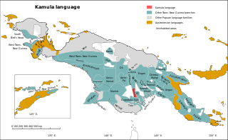
Kamula is a Trans–New Guinea language that is unclassified within that family in the classification of Malcolm Ross (2005). Noting insufficient evidence, Pawley and Hammarström (2018) leave it as unclassified.

Tabo, also known as Waia (Waya), is a Papuan language of Western Province, Papua New Guinea, just north of the Fly River delta. The language has also been known as Hiwi and Hibaradai.
Taulil is a Papuan language spoken in East New Britain Province on the island of New Britain, Papua New Guinea.
One is a Torricelli dialect cluster of West Wapei Rural LLG in Sandaun Province, Papua New Guinea.
Tumleo is an Austronesian language of coastal Sandaun Province, Papua New Guinea, on Tumleo Island and the Aitape coast in East Aitape Rural LLG.
References
- A. Capell "A lost tribe in New Ireland" Taja December 1967 Vol. 6 No. 10, pp. 499–509
- F. L. S. Bell "Report on field work in Tanga" Oceania March 1934 Vol. 4 No. 3, pp. 290–309
- F. L. S. Bell "Warfare among the Tanga" Oceania March 1935 Vol. 5 No. 3, pp. 253–279
- F. L. S. Bell "Sokapana: A Melanesian Secret Society" The Journal of the Royal Anthropological Institute Vol. 65 (July–December 1935), pp. 311–341
- F. L. S. Bell "Courtship and marriage among the Tanga" Taja December 1935 Vol. 1 No. 12, pp. 20–20
- F. L. S. Bell "Dafal" The Journal of the Polynesian Society 1936 Vol. 45 No. 179, pp. 83–98
- F. L. S. Bell "The avoidance situation in Tanga" Oceania March 1936 Vol. 6 No. 3, pp. 306–322
- F. L. S. Bell "Death in Tanga" Oceania March 1937 Vol. 7 No. 3, pp. 316–339
- F. L. S. Bell "The place of food in the social life of the Tanga" Oceania March 1948 Vol. 6 No. 3, pp. 233–247
- F. L. S. Bell "The narrative in Tanga" Taja September 1949 Vol. 4 No. 3, pp. 99–101
- F. L. S. Bell "Land Tenure in Tanga" Oceania September 1953 Vol. 24 No. 1, pp. 28–57
- F. L. S. Bell "Male and Female in Tanga: Being a Description of Certain Sexual Aspects of the Ritual Life" Taja September 1957 Vol. 5 No. 4, pp. 137–148
- F. L. S. Bell "Tanga-English, English-Tanga dictionary" Oceania lingusitic monographs, No.21, 1977 Sydney, University of Sydney