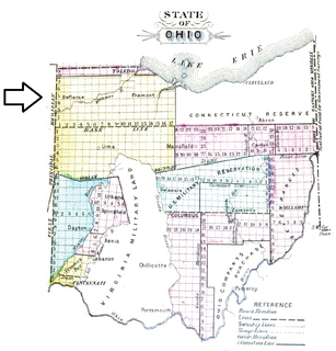
The Toledo War (1835–36), also known as the Michigan–Ohio War or the Ohio–Michigan War, was an almost bloodless boundary dispute between the U.S. state of Ohio and the adjoining territory of Michigan over what is now known as the Toledo Strip. Control of the mouth of the Maumee River and the inland shipping opportunities it represented, and the good farmland to the west were seen by both parties as valuable economic assets.
Lucas County is a county located in the northwestern part of the U.S. state of Ohio. It is bordered to the east by Lake Erie, and to the southeast by the Maumee River, which runs to the lake. As of the 2020 census, the population was 431,279. Its county seat is Toledo, located at the mouth of the Maumee River on the lake. The county was named for Robert Lucas, 12th governor of Ohio, in 1835 during his second term. Its establishment provoked the Toledo War conflict with the Michigan Territory, which claimed some of its area. Lucas County is named after Robert Lucas, 12th Governor of the State of Ohio and the winning governor of the Toledo War, and is the central county of the Toledo Metropolitan Statistical Area.

Monroe County is a county in the U.S. state of Michigan. As of the 2020 Census, the population was 154,809. The largest city and county seat is Monroe. The county was established as the second county in the Michigan Territory in 1817 and was named for then-President James Monroe.
The following is timeline of events surrounding the Toledo War, a mostly bloodless conflict between the State of Ohio and the Michigan Territory in 1835-36, over a 468-square-mile (1,210 km2) disputed region along their common border, now known as the Toledo Strip after its major city.

The Ottawa River, also known as Ottawa Creek, is a short river, approximately 20 miles (32 km) long, in northwest Ohio and southeast Michigan in the United States. It drains an area on the Ohio-Michigan border along the eastern and northern fringes of the city of Toledo, goes through Ottawa Hills, and empties directly into Lake Erie. It is one of two rivers in northwestern Ohio that share the same name, along with the Ottawa River that is a tributary of the Auglaize River. The upper 4 miles (6 km) of the river in Michigan north of Sylvania, Ohio is called North Tenmile Creek on federal maps, while another branch rising in Fulton County, Ohio, is called Tenmile Creek.
The U.S. District Court for the Northern District of Ohio is the federal trial court for the northern half of Ohio–essentially everything north of the Columbus area. The court has courthouses in Cleveland, Toledo, Akron and Youngstown.
Turtle Island is a 1.5-acre (0.61 ha) island in the western portion of Lake Erie in the United States. The island has an unusual political status, as its jurisdiction is divided between the U.S. states of Michigan and Ohio, even though the island has no residents or current use. Turtle Island is located about five miles (8.0 km) northeast of the mouth of the Maumee River in Maumee Bay. Today, the island houses several abandoned structures and the ruins of Turtle Island Light, a lighthouse dating back to 1866. According to the Census Bureau, most of the island physically lies in Jerusalem Township in Lucas County, Ohio with the smaller Michigan portion being part of Erie Township in Monroe County, Michigan.

This is a list of high school athletic conferences in Ohio, separated by Ohio High School Athletic Association (OHSAA) region. Some conferences have schools in multiple regions, and will be listed in all applicable regions. However, the conference information is on the region page where the most schools are classified in.

Ohio's 5th congressional district is in northwestern and north central Ohio and borders Michigan and Indiana. The district is currently represented by Republican Bob Latta. The district borders have changed somewhat from the previous redistrict as some of the easternmost counties were redistricted to other districts.

The Diocese of Toledo in America is a Latin Church ecclesiastical jurisdiction or diocese of the Catholic Church covering nineteen counties in northwestern Ohio. It is a suffragan see of the metropolitan Archdiocese of Cincinnati. The See city for the diocese is Toledo. The eighth and current bishop of Toledo is Daniel Edward Thomas. Our Lady, Queen of the Most Holy Rosary Cathedral is the mother church of the diocese.

Northwest Ohio, or Northwestern Ohio, consists of multiple counties in the northwestern corner of the US state of Ohio. This area borders Lake Erie, Southeast Michigan, and northeastern Indiana. Some areas are also considered the Black Swamp area. The Toledo metropolitan area is part of the region.
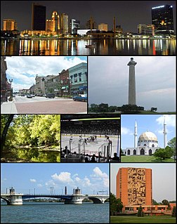
The Toledo Metropolitan Area, or Greater Toledo, or Northwest Ohio is a metropolitan area centered on the American city of Toledo, Ohio. As of the 2010 census, the metropolitan statistical area (MSA) had a population of 651,429. It is the sixth-largest metropolitan area in the state of Ohio, behind Cincinnati–Northern Kentucky, Cleveland, Columbus, Dayton, and Akron.
The Toledo–Lucas County Port Authority is a port authority financing and/or operating air, rail, trucking, and port facilities, as well as supporting and funding economic development activities in Lucas County, located in northwest Ohio and bordering on southeast Michigan.

Lake Erie Basin consists of Lake Erie and surrounding watersheds, which are typically named after the river, creek, or stream that provides drainage into the lake. The watersheds are located in the states of Indiana, Michigan, New York, Ohio, and Pennsylvania in the United States, and in the province of Ontario in Canada. The basin is part of the Great Lakes Basin and Saint Lawrence River Watershed, which feeds into the Atlantic Ocean. 80% of the lake's water flows in from the Detroit River, with only 9% coming from all of the remaining watersheds combined. A littoral zone serves as the interface between land and lake, being that portion of the basin where the lake is less than 15 feet (4.6 m) in depth.
Sandusky is a city in the U.S. state of Ohio and the county seat of Erie County. Situated in northern Ohio on the shores of Lake Erie, Sandusky is located roughly midway between Toledo and Cleveland.
North and East of the First Principal Meridian is a survey and land description in the northwest part of the U.S. state of Ohio.
Since the OHSAA began basketball competition in 1922-23, many schools have decided to band together in conferences to help scheduling, added competition for titles and bragging rights, and oftentimes help determine seeding for the early rounds of the state tournament. Some conferences had been established for football-playing schools, and as schools added other sports, adopted those under the conference banner once enough schools started playing. Smaller schools often picked up basketball first, adding other sports later, and combined with other in-county schools to form County conferences. Most of these leagues were formed in the 1920s and early 1930s after the tournament was started, which is why quite a few lack a definitive starting date at this point in time.
This is a list of former high school athletic conferences in the Northwest Region of Ohio, as designated by the OHSAA. If a conference had members that span multiple regions, the conference is placed in the article of the region most of its former members hail from. Because the names of localities and their corresponding high schools do not always match and because there is often a possibility of ambiguity with respect to either the name of a locality or the name of a high school, the following table gives both in every case, with the locality name first, in plain type, and the high school name second in boldface type. The school's team nickname is given last.

The North Coast Inland Trail is a work-in-process multipurpose trail project that currently consists of several separate portions, defined by their counties, in northern Ohio, United States. Affiliates with the trails have high hopes to connect all of these portions and to extend the trails into Indiana and Pennsylvania, two of Ohio's land-bordering states.