Tornado outbreak of April 2, 2006

Last updated

Tornado outbreak of April 2, 2006
Tornado southofKennett.jpg
The F3 Marmaduke/Caruthersville tornado near Kennett, Missouri
TypeTornado outbreak
DurationApril 2, 2006
Tornadoes
confirmed
66 confirmed
Max. rating1 F3 tornado
Duration of
tornado outbreak2
6 hours, 43 minutes
Fatalities27 fatalities [1] (+2 non-tornadic), 348 injuries
Damage$1.1 billion [2] [1]
Areas affected Midwestern United States, Mississippi River Valley
1Most severe tornado damage; see Fujita scale
2Time from first tornado to last tornado

During the late afternoon and evening of April 2, 2006, a series of tornadoes broke out in the central United States. It was the second major outbreak of 2006, in the same area that suffered considerable destruction in a previous outbreak on March 11 and 12, as well as an outbreak on November 15, 2005. [3] The most notable tornadoes of the outbreak struck northeastern Arkansas, the Missouri Bootheel, and West Tennessee, where several communities including Marmaduke, Arkansas, Caruthersville, Missouri, and Newbern, Tennessee suffered devastating damage. In total, 66 tornadoes touched down across seven states, which is the most in a single day in 2006. In addition, there were over 850 total severe weather reports, including many reports of straight-line winds exceeding hurricane force and hail as large as softballs, which caused significant additional damage in a nine-state region. [4]

Contents

The outbreak caused 27 tornado-related deaths plus two other deaths from straight-line winds. [5] [6] It was the deadliest tornado outbreak in the United States since the tornado outbreak sequence of May 2003, which killed 48 people. Twenty-six of those deaths were caused by a single supercell thunderstorm which produced damaging and long lived tornadoes from north central Arkansas into northwest Tennessee.

Meteorological synopsis

The outbreak was caused by a cold front that tracked across the central United States, triggered by a deep low-pressure area in the Upper Midwest. The warm humid air mass ahead of the cold front, along with high upper-level wind shear, produced supercells across the region. [7]

The outbreak was expected to have started the previous day in the High Plains as the cold front tracked across that region. The supercells didn't really fire up as expected and only one small tornado was reported in Pawnee County, Kansas on April 1. Severe weather that day was largely restricted to significant microbursts and large hail. [8]

The Storm Prediction Center (SPC) issued a moderate risk of severe weather for April 2, with the main risks being tornadoes and large hail. [7] The primary risk area was the central Mississippi Valley and lower Ohio Valley up to central Illinois, where most of the tornadoes touched down. Many tornado watches  – if not any PDS watches – were issued across the region. While a significant severe weather event was expected, the extreme nature caught many forecasters by surprise, based on the risk levels and the probabilities estimated by the SPC in the area primarily affected. [9]

Farther north, the initial thunderstorm development in eastern Missouri quickly developed into a squall line, eventually becoming a derecho that produced many embedded – and generally weak – tornadoes and widespread wind damage across Illinois, Indiana, Kentucky, and Ohio. Springfield, Illinois, which was struck by two tornadoes less than a month earlier, was hit again by tornadoes and damaging straight-line winds of up to 80 miles per hour (70 kn; 130 km/h), as was the St. Louis, Missouri area. [10] Wind damage was reported in Cincinnati, Louisville, Kentucky, and Indianapolis, among other cities. [4]

The line of storms slowly weakened while traveling eastward, and the severe weather events dissipated later that evening.

Confirmed tornadoes

Confirmed tornadoes by Fujita rating
FUF0F1F2F3F4F5Total
02725860066
List of confirmed tornadoes – Sunday, April 2, 2006
F# LocationCountyTime (UTC)Path lengthDamage
Iowa
F0SW of Bloomfield Davis 2047unknownBrief touchdown over open fields with no damage. [11]
F0N of Pulaski Davis 2057unknownBrief "pencil-thin" tornado remained over open fields with no damage. [12]
F2W of Pittsburg Van Buren 21013 miles
(5 km)
Two houses lost their roofs and four outbuildings were destroyed. Many trees and power lines were downed as well. [13]
F1N of Mount Zion Van Buren 21092.5 miles
(4 km)
A roof was blown off a barn with minor roof damage to a house. Several outbuildings were destroyed with tree damage noted. [14]
F1S of Fairfield Jefferson 2118unknownBrief tornado touchdown destroyed an outbuilding. [15]
F1E of Stockport Van Buren 21193 miles
(5 km)
Several outbuildings were destroyed and numerous trees were knocked down. [16]
F2 Washington Washington 21471 mile
(1.6 km)
Tornado struck the west side of town. A garage was completely unroofed and a shed was destroyed. Numerous trees were snapped along the path, and metal sheeting was torn off a business near the end of the path. [17]
F1S of Riverside Washington 2200unknownPower lines were knocked down by this brief tornado. [18]
F0SW of Hartford Warren 2206unknownBrief tornado remained over open fields with no damage. [19]
F0N of Runnells Polk 2231unknownBrief tornado remained over open fields with no damage. [20]
Missouri
F2NE of Perry to SE of Hatch Ralls 21253.2 miles
(5 km)
Near Clarence Cannon Dam, a convenience store sustained minor damage, a pole barn was destroyed and scattered, and two boats were flipped over. An RV dealership was badly damaged, sustaining collapse of its service bay, and with only one wall left standing on the second floor. At least 30 campers sustained some type of damage, and 8 to 10 of them were completely destroyed. Some of the camper frames were found 150 to 200 feet north of their initial positions, and debris from this area was scattered over 1/4 mile away. Three 1x3 inch boards were found stuck in the dealerships hard packed gravel lot. Further along the path, a pole barn was damaged, many trees were snapped, and a metal sign was stuck 4–6 inches into a tilled field. [21]
F0 Park Hills St. Francois 2200150 yd
(130 m)
Caused minor damage to the roofs of three houses and an auto business. Numerous tree limbs were also snapped. [22]
F0SW of Weingarten Ste. Genevieve 22052 miles
(3.2 km)
Three farms sustained minor home and machine shed damage, while several trees were snapped or uprooted. [23]
F0N of Sikeston Scott 23432 miles
(3.2 km)
Several buildings on a farm sustained minor damage, along with the roof of a house. [24]
Arkansas
F1SW of Williford to E of Ravenden Sharp, Lawrence 215910 miles
(16 km)
In Sharp County, a barn and a workshop were damaged, and many trees were snapped or uprooted. In Lawrence County, up to 40 homes were damaged. In the town of Ravenden, a barn, a rental house, and 4 unoccupied buildings were damaged. [25]
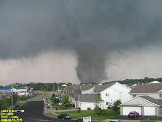
F3S of Pocahontas, AR to Caruthersville, MO Randolph (AR), Greene (AR), Dunklin (MO), Pemiscot (MO) 223777 miles
(124 km)
2 deaths See section on this tornado .
F2SE of Armstrong Springs to N of Searcy White 22356.3 miles
(10 km)
Tornado destroyed two mobile homes, and several other mobile homes were damaged. A self-storage warehouse was damaged as were three other businesses. Several dozen trees were uprooted, and power lines were downed. A number of vehicles were badly damaged as well. [26]
F3SE of Morton to W of Crawfordsville Woodruff, Cross, Crittenden 235222 miles
(35 km)
In Woodruff County, the tornado was at F0 intensity, with limited to trees and power lines. In Cross County, the tornado reached F3 intensity and struck the small community of Fitzgerald Crossing, where 10 homes were destroyed or had major damage, with 27 homes and 5 mobile homes receiving minor damage. Village Creek State Park sustained damage to its visitor's center and tennis court. Two buildings sustained minor damage in Crittenden County, before the tornado dissipated. Many trees were snapped and uprooted along the path, and 5 people were injured. [27]
Illinois
F1S of Blandinsville McDonough 221412 miles
(20 km)
A maintenance garage, two wooden barns, a metal pole barn, and 7 grain bins were destroyed. 4 grain bins were damaged, and extensive tree damage occurred as well. [28]
F0NE of Piasa Macoupin 22152 miles
(3.2 km)
A mobile home was destroyed, and a grain bin and some farm buildings were damaged. [29]
F0 Piasa Macoupin 22150.5 mile
(800 m)
Numerous homes in town sustained roof and siding damage, and extensive tree and power line damage occurred. A barn was destroyed, a parking canopy collapsed, and a car was pushed off of a road. [30]
F2 Fairview Heights/O'Fallon areas St. Clair 2215unknown1 death – A clothing store sustained collapse of its roof, and a church sustained roof and steeple damage. Numerous homes were damaged, some heavily. One home had its roof torn off and thrown 100 yards. Many trees and power lines were downed as well, and 11 people were injured. [31]
F0N of Terre Haute Henderson 2218unknownBrief touchdown caused no damage. [32]
F0S of Dorsey to SW of Staunton Madison, Macoupin 222016 miles
(26 km)
Near Dorsey, trees were damaged and roof shingles were blown off of a couple of homes. Damage to trees, power lines, and shingles occurred near Staunton as well. [33]
F1SW of Highland Madison 22302 miles
(3.2 km)
A garage and a machine shed were destroyed, and homes sustained roof, window, and siding damage. Power poles were snapped as well. [34]
F0N of Gillespie Macoupin 2235100 yd
(90 m)
One mobile home was destroyed. [35]
F0N of Walshville Montgomery 22411 mile
(1.6 km)
Damaged limited to a single farm, where a house suffered minor roof damage and a shed was destroyed. Some trees were downed as well. [36]
F1SW of Loami Sangamon 22460.5 mile
(800 m)
Several large trees and some power lines were downed. [37]
F1NE of Berlin Sangamon 22492 miles
(3.2 km)
A grain bin and a pole barn were destroyed, and another pole barn was damaged. Trees were snapped as well. [38]
F2 Hillsboro to E of Nokomis Montgomery 225020 miles
(32 km)
In Hillsboro, two gas stations and a car dealership sustained window and sign damage. Metal sheeting was blown into trees as well. East of town, several barns were destroyed, with debris scattered up to a mile away. Grain bins and machine sheds were also heavily damaged, and two high-tension truss towers were toppled. [39]
F1N of Chatham Sangamon 22561 mile
(1.6 km)
Several homes sustained roof damage. [40]
F1E of Farmersville to NW of Morrisonville Montgomery, Christian 22563 miles
(5 km)
Several outbuildings, grain bins, and barns were heavily damaged at three farms. [41]
F1 Springfield (1st tornado) Sangamon 22581 mile
(1.6 km)
Damage reported in the same area hit on March 12, with minor roof and structural damage to several businesses.
F0SW of Pawnee Sangamon 22591.3 miles
(2 km)
Three grain bins were overturned and destroyed, and three barns were also damaged. Trees were downed as well. [42]
F1 Springfield (2nd tornado) Sangamon 23060.75 mile
(1.2 mile)
Fourth and final tornado to strike Springfield in 2006. The Illinois Department of Transportation building sustained roof damage. [43]
F1 Taylorville Christian 23086.3 miles
(10 km)
Multiple homes and businesses in town sustained roof and structural damage. Sheds were damaged and numerous trees were downed as well. One person was injured. [44]
F1S of Riverton Sangamon 23131.5 miles
(2.4 mile)
Tornado struck a mobile home park, destroying 8 homes and damaging 30 others. Numerous trees were blown down and one person was injured. [45]
F1N of Oconee to Pana Shelby, Christian 23156 miles
(9.5 km)
A shed had its roof torn off and another shed was blown across a field. In Pana, many trees were downed and homes sustained roof damage. [46]
F0NE of Taylorville Christian 2317unknownBrief touchdown in an open field with no damage. [47]
F1 Assumption Christian 23201 miles
(1.6 km)
Minor roof and tree damage occurred in town. [48]
F0 Greenview Menard 23220.25 mile
(400 m)
A house sustained minor siding damage. [49]
F0E of Niantic Macon 23300.1 mile
(150 m)
Brief touchdown in an open field with no damage. [49]
F2SW of Macon Macon 23304.5 miles
(7.5 km)
One large barn was destroyed with debris scattered up to a mile away. A house sustained minor roof damage as well. [50]
F0SE of Lincoln Logan 23321 miles
(1.6 km)
Tornado damaged a barn, blew down a large tree, and damaged a grain storage bin. [51]
F0NW of Chestnut Logan 23362.5 miles
(4 km)
Tornado caused roof damage to several barns, blew down a few trees, and damaged shingles on homes. [52]
F1SW of Elwin to S of Decatur Macon 23367.5 miles
(11.5 km)
Tornado snapped power poles and blew down numerous trees along its path. It damaged the roof of several structures and broke a window and some signs at a strip mall. Three people were injured by flying glass. [53]
F0 Neoga Cumberland 23420.75 mile
(1.2 km)
The roof was damaged at a local school, plus several trees were knocked down. [54]
F0N of Weldon De Witt 00010.1 mile
(150 m)
Tornado remained in open fields with no damage. [55]
F0S of Towanda McLean 00080.1 mile
(150 m)
Tornado remained in open fields with no damage. [56]
F0S of Arrowsmith McLean, Woodford 00120.5 mile
(800 m)
A barn was destroyed, and another barn had its metal roof torn off. Three concrete grain silos were destroyed as well. [57]
F0 Champaign area Champaign 00150.1 mile
(150 m)
Brief touchdown with no damage. [58]
F0SW of Saybrook McLean, Livingston 00222.25 miles
(3.5 km)
Tornado remained over open fields with no damage. [59]
F0 Flatville Champaign 00250.25 mile
(400 m)
Minor structural damage occurred in town. [60]
Tennessee
F3N of Lenox to E of Newbern Dyer, Gibson 003018 miles
(29 km)
16 deaths – This devastating tornado affected rural areas before it struck the north edge of Newbern, where major damage occurred. 71 homes were destroyed and 182 others were damaged. Some frail homes were swept completely away. 70 people were injured. [61]
F3W of Dyer to S of McKenzie Gibson, Weakley, Carroll 010931 miles
(50 km)
6 deaths – Tornado touched down and caused some damage in Dyer before rapidly intensifying and striking Bradford. Bradford was severely damaged, with 75 homes destroyed and 250 others damaged. The police station was destroyed, and several businesses were heavily damaged. The tornado then passed near Pillowville, with 4 homes destroyed and 38 others damaged in that area. Two barns were destroyed as well. South of McKenzie, 34 homes, two apartments, one shop building, and 9 farm buildings were damaged. A church and some grain bins were also destroyed before the tornado dissipated. 44 people were injured, and many trees and power lines were downed along the path. All fatalities occurred in Bradford. [62]
F3N of Rutherford Gibson 012510 miles
(16 km)
2 deaths – 6 homes were destroyed and 250 others were damaged. Vehicles were picked up and thrown into fields. 6 people were injured. [63]
F1 Longtown area Fayette 02451 mile
(1.6 km)
Ten homes and two businesses were damaged, along with many barns and outbuildings. Numerous trees and power lines were downed and two people were injured. [64]
F1SW of Camden Benton 0255unknownA trucking company was completely destroyed, with debris scattered up to 2 miles away. [65]
F2W of Brownsville Haywood 03250.75 mile
(1.2 km)
Considerable damage occurred in the Hickory Mills subdivision. 24 homes sustained roof damage, and one was destroyed. Another home was moved off of its foundation. [66]
Kentucky
F0E of Gage McCracken 0031unknownTornado remained over open country with no damage. [67]
F3N of Hopkinsville Christian, Todd 015030 miles
(48 km)
Large wedge tornado. In Christian County, 91 homes were destroyed and 171 others were damaged. Numerous garages, barns, and outbuildings were destroyed, and some vehicles were damaged or destroyed as well. Hundreds of trees were downed, snapped, or uprooted, and several metal high-tension towers were toppled, cutting off power to Hopkinsville for 6 hours. In Todd County, 2 homes were destroyed and 28 others were damaged. Close to two dozen sheds and barns were damaged or destroyed, along with at least one grain bin. Numerous trees were uprooted, and some farm machinery and vehicles were damaged or destroyed, including tractors and combines. A church had its roof torn off and its windows blown out in Cedar Grove before the tornado dissipated. Gas leaks were reported in the area, and 28 people were injured. [68]
F1N of Shelbyville Shelby 02152 miles
(3.2 km)
Anticyclonic tornado damaged trees and power lines. [69]
F1SE of Edwards Logan 03302 miles
(3.2 km)
Unknown minor damage occurred. [70]
Indiana
F1 Mitchell Lawrence 0105unknownA few homes and businesses were damaged in town. [71]
F1SE of Romney Tippecanoe 0110unknownMinor damage occurred, mostly to outbuildings. [72]
F1 Seymour Jackson 0145unknownMinor to moderate damage to several houses in town. Numerous trees and power lines also knocked down. [73]
Sources: SPC Storm Reports for 04/02, Little Rock office, Quad Cities office, Memphis office, Paducah office, Lincoln office, Nashville office, Indianapolis office, Louisville office, National Climatic Data Center

Marmaduke, Arkansas/Caruthersville, Missouri

Marmaduke, Arkansas/Caruthersville, Missouri
F3 tornado
Max. rating1 F3 tornado
Fatalities2 fatalities, 177 injuries
Damage$86.5 million (2006 USD)
1Most severe tornado damage; see Fujita scale

The most infamous tornado of the outbreak touched down in Randolph County, Arkansas just south of Pocahontas. The tornado first struck the small community of Shannon at F1 intensity. 3 businesses and 5 homes were destroyed. Another two businesses and two homes had major damage, and 18 other homes had minor damage. [74] Past Shannon, the tornado rapidly intensified into a large high-end F3 as it crossed into Greene County and slammed into the town of Marmaduke. The town was devastated, with 130 homes and 25 mobile homes being destroyed. A pharmacy and some industrial buildings were also destroyed, and the town's water tower was damaged. Multiple vehicles were tossed around, and 15 railroad cars were blown off of the tracks as well. 47 people were injured in town, two of which were airlifted to a hospital. Outside of town, 19 homes and 11 mobile homes were destroyed. In addition, seven houses and two mobile homes had major damage in the county. A car was thrown 80 yards from one residence well. [75] [76]

The tornado then crossed the St. Francis River into Dunklin County, Missouri, where it displayed a multiple-vortex structure. 7 homes were destroyed and 33 others were damaged in rural portions of the county. Multiple power poles were downed as well. [77] The tornado then crossed into Pemiscot County, and struck the town of Braggadocio at F2 intensity. The tornado's only two fatalities occurred at that location when a couple was killed in their car as they tried to flee from the tornado. The tornado then re-intensified to a high-end F3 as it tore through the neighboring town of Caruthersville, destroying roughly half of the community and injuring 130 people. 226 homes were destroyed, and 542 others were damaged in town. The town's water tower, municipal airport, several churches, Caruthersville High School and Middle School, and multiple businesses were destroyed as well. The tornado abruptly dissipated just outside town after traveling 77 miles. [75] [78]

Aftermath

Six months after the tornado, debris remained scattered throughout Marmaduke. Many homes and businesses had been rebuilt; while many others remained in their tornado-damaged state. The Marmaduke water tower, which was heavily damaged, was torn down shortly after the tornado. The primary employer in the area, American Railcar Industries, rebuilt its facility and quickly returned it to operational status. [79]

On August 29, 2006, Caruthersville Emergency Manager and Fire Chief Charlie Jones was awarded the StormReady Community Hero Award for his actions preventing further injuries and fatalities in the area. He ordered the sirens to sound repeatedly and used the fire department's communications frequency to warn of the imminent and extreme danger that lay ahead, which saved many lives that evening. There were no deaths in Caruthersville as a result. [80] More than half the community was destroyed. Charitable outpouring was enormous and several key buildings, including one of the schools, have been rebuilt. [81]

Numerous FEMA trailers  – intended for Hurricane Katrina victims but unused and sitting nearby – were redirected to the communities affected in Arkansas, Missouri, and Tennessee after the tornadoes hit. [79]

Damage images

See also

Related Research Articles

<span class="mw-page-title-main">Wisconsin tornado outbreak of 2005</span>

The Wisconsin tornado outbreak of 2005 was an outbreak of tornadoes that occurred primarily in southern Wisconsin on August 18, 2005. A system of storms unleashed a total of 28 tornadoes, 27 of which were confirmed in southern Wisconsin, and 1 confirmed in Minnesota. This outbreak set a new record for the most tornadoes observed in the state in a single day, breaking the previous record of 24 tornadoes set on May 8, 1988. The system generating the Stoughton tornado was also accompanied by many reports of severe winds and hail throughout the region. The Stoughton tornado was documented on an episode of The Weather Channel's Storm Stories.

The St. Louis metropolitan area has a history of tornadoes. The third-deadliest, and the costliest in United States history, the 1896 St. Louis–East St. Louis tornado, injured more than one thousand people and caused at least 255 fatalities in the City of St. Louis and in East St. Louis. The second-costliest tornado also occurred in St. Louis in September 1927. More tornado fatalities occurred in St. Louis than any other city in the United States. Also noteworthy is that destructive tornadoes occurred in winter and autumn, as well as the typical months of spring. Additionally, damaging tornadoes occurred in the morning and late at night, as well as the more common late-afternoon to early-evening maximum period.

<span class="mw-page-title-main">Tornado outbreak sequence of March 9–13, 2006</span> Weather event sequence

The Tornado outbreak sequence of March 9–13, 2006 was an early season and long lasting tornado outbreak sequence in the central United States that started on the morning of March 9 and continued for over four days until the evening of March 13. The outbreak produced 99 confirmed tornadoes, which killed a total of 10 people. The Storm Prediction Center (SPC) issued multiple elavated outlook throughout the sequence, including a rare high risk for March 12, which would end up being the most intense day of the outbreak, producing 62 in total. 11 F3 tornadoes were tallied, and a violent F4 tornado touched down in Monroe County, Missouri, becoming the strongest of the outbreak. Multiple tornado emergencies were issued for tornadoes throughout the outbreak as well. An intense F3 tornado that affected the towns of Renick and Maddison in Missouri killed 4 people and injured dozens others, becoming the deadliest of the sequence. Multiple of the tornadoes were long-tracked in nature, with 6 of them having paths exceeding 30 miles (48 km). One particular supercell thunderstorm during the outbreak persisted for many hours and progressed in excess of 800 miles (1,300 km) through Oklahoma, Kansas, Missouri, Illinois, Indiana, and extreme southern Michigan.

The Tornado outbreak of September 21–23, 2006 was a significant tornado outbreak that occurred across a large swath of the Central United States from September 21 – September 23, 2006. 48 tornadoes were confirmed.

<span class="mw-page-title-main">Tornado outbreak of November 14–16, 2006</span>

From November 15 to 16, 2006, a major tornado outbreak occurred across the Southern United States and into the Mid-Atlantic States. Ten people were killed by the many tornadoes that damaged many communities. The bulk of the tornadoes took place on November 15, but the deadliest tornado took place on the morning of November 16 in southern North Carolina. In total, 32 tornadoes were confirmed. Additionally, this was the last outbreak that used the original Fujita scale for measuring tornado intensity, as it was being superseded by the Enhanced (EF) scale in January 2007.

<span class="mw-page-title-main">Tornadoes of 2004</span>

This page documents notable tornadoes and tornado outbreaks worldwide in 2004. Strong and destructive tornadoes form most frequently in the United States, Bangladesh, and Eastern India, but they can occur almost anywhere under the right conditions. Tornadoes also develop occasionally in southern Canada during the Northern Hemisphere's summer and somewhat regularly at other times of the year across Europe, Asia, and Australia. Tornadic events are often accompanied with other forms of severe weather, including strong thunderstorms, strong winds, and hail.

<span class="mw-page-title-main">Tornadoes of 2001</span>

This page documents notable tornadoes and tornado outbreaks worldwide in 2001. Strong and destructive tornadoes form most frequently in the United States, Bangladesh, and Eastern India, but they can occur almost anywhere under the right conditions. Tornadoes also develop occasionally in southern Canada during the Northern Hemisphere's summer and somewhat regularly at other times of the year across Europe, Asia, and Australia. Tornadic events are often accompanied with other forms of severe weather, including strong thunderstorms, strong winds, and hail.

<span class="mw-page-title-main">Tornado outbreak of February 28 – March 2, 2007</span> Windstorm in the southern United States from Feb 28 - March 2, 2007

The tornado outbreak of February 28 – March 2, 2007 was a deadly tornado outbreak across the southern United States that began in Kansas on February 28, 2007. The severe weather spread eastward on March 1 and left a deadly mark across the southern US, particularly in Alabama and Georgia. Twenty deaths were reported; one in Missouri, nine in Georgia, and 10 in Alabama. Scattered severe weather was also reported in North Carolina on March 2, producing the final tornado of the outbreak before the storms moved offshore into the Atlantic Ocean.

<span class="mw-page-title-main">Tornado outbreak of March 28–31, 2007</span> Severe storms in the central United States

The tornado outbreak of March 28–31, 2007, also known as the Late-March 2007 tornado outbreak, was a tornado outbreak that took place across the central United States. It developed in the High Plains from South Dakota to central Texas on March 28, 2007, which produced most of the tornadoes. Several more tornadoes were reported the next three days before the system weakened on March 31. It affected western Nebraska, western Kansas, extreme eastern Colorado, and much of Oklahoma, and Texas. It was the second major outbreak of 2007, four weeks after an outbreak farther east. The outbreak produced 80 confirmed tornadoes, with five deaths and extensive damage being reported. In addition to the tornadoes, widespread hail as large as softballs and destructive straight-line winds as strong as 90 mph (140 km/h) were reported.

<span class="mw-page-title-main">Tornado outbreak of May 4–6, 2007</span> 2007 tornado outbreak in the United States

From May 4–6, 2007, a major and damaging tornado outbreak significantly affected portions of the Central United States. The most destructive tornado in the outbreak occurred on the evening of May 4 in western Kansas, where about 95% of the city of Greensburg in Kiowa County was destroyed by an EF5 tornado, the first of such intensity since the 1999 Bridge Creek–Moore tornado. The supercell killed 13 people, including 11 in Greensburg and two from separate tornadoes. At least 60 people were injured in Greensburg alone. It was the strongest tornado of an outbreak which included several other tornadoes reported across Oklahoma, Colorado, Kansas and South Dakota that occurred on the same night.

<span class="mw-page-title-main">Tornado outbreak of October 17–19, 2007</span> 2007 tornado outbreak in the United States

The tornado outbreak of October 17–19, 2007 was a widespread tornado outbreak that took place across much of the eastern half of North America starting on October 17, 2007, and continuing into the early hours of October 19. The outbreak was also responsible for five deaths; three in Michigan and two in Missouri, plus many injuries. At least 64 tornadoes were confirmed including 16 on October 17 across six states including Texas, Oklahoma, Arkansas, Louisiana, Mississippi and Missouri with wind damage reported in Oklahoma, Kansas, Illinois, Iowa, Arkansas and Mississippi. On October 18, at least 48 tornadoes were confirmed across eight states including Florida, Alabama, Mississippi, Tennessee, Kentucky, Illinois, Indiana and Michigan, plus widespread straight line wind damage. Until 2010, this event held the record for largest tornado outbreak ever recorded in the month of October according to NOAA.

<span class="mw-page-title-main">Satellite tornado</span> Tornado that orbits around a parent tornado

A satellite tornado is a tornado that revolves around a larger, primary tornado and interacts with the same mesocyclone. Satellite tornadoes occur apart from the primary tornado and are not considered subvortices; the primary tornado and satellite tornadoes are considered to be separate tornadoes. The cause of satellite tornadoes is not known. Such tornadoes are more often anticyclonic than are typical tornadoes and these pairs may be referred to as tornado couplets. Satellite tornadoes commonly occur in association with very powerful, large, and destructive tornadoes, indicative also of the strength and severity of the parent supercell thunderstorm.

<span class="mw-page-title-main">Tornado outbreak of March 2–3, 2012</span> Windstorm in the southern United States

On March 2 and 3, 2012, a deadly tornado outbreak occurred over a large section of the Southern United States into the Ohio Valley region. The storms resulted in 41 tornado-related fatalities, 22 of which occurred in Kentucky. Tornado-related deaths also occurred in Alabama, Indiana, and Ohio. The outbreak was the second deadliest in early March for the U.S. since official records began in 1950; only the 1966 Candlestick Park tornado had a higher death toll for a tornadic system in early March.

<span class="mw-page-title-main">Tornadoes of 1963</span>

This page documents the tornadoes and tornado outbreaks of 1963, primarily in the United States. Most tornadoes form in the U.S., although some events may take place internationally. Tornado statistics for older years like this often appear significantly lower than modern years due to fewer reports or confirmed tornadoes.

This page documents the tornadoes and tornado outbreaks of 1951, primarily in the United States. Most tornadoes form in the U.S., although some events may take place internationally. Tornado statistics for older years like this often appear significantly lower than modern years due to fewer reports or confirmed tornadoes.

This page documents the tornadoes and tornado outbreaks of 1950, primarily in the United States. Most tornadoes form in the U.S., although some events may take place internationally.

<span class="mw-page-title-main">Tornado outbreak sequence of June 20–23, 1957</span>

A deadly and destructive outbreak sequence of 23 tornadoes struck parts of the Great Plains and the Great Lakes in late-June 1957. At least seven significant tornadoes (F2+) touched down during the outbreak sequence. The most devastating storm was a large, violent, and catastrophic 500-yard-wide F5 tornado family that struck Fargo, North Dakota on Thursday, June 20, 1957, killing 10 people and becoming the deadliest tornado ever recorded in North Dakota. The outbreak caused 11 fatalities, 105 injuries, and $25.883 million in damage.

A destructive and deadly outbreak of 17 tornadoes occurred on February 9–10, 1959, mostly during the overnight hours, causing widespread destruction in the Midwest and Southeast regions of the United States. The strongest of the outbreak was a violent F4 tornado which tore through Northwestern Downtown St. Louis. An F3 tornado also caused heavy damage to numerous structures in Southern Highland County, Ohio, including a school that was in session at the time the tornado hit. Overall, the outbreak caused 21 fatalities, 358 injuries, and $53.713 million in damage. Non-tornadic impacts also caused two more fatalities, and at least 70 more injuries.

References

  1. 1 2 Horstmeyer, Steven L. (September 23, 2011). The Weather Almanac: A Reference Guide to Weather, Climate, and Related Issues in the United States and Its Key Cities. John Wiley & Sons. p. 206. ISBN   978-1-118-01520-9.
  2. "Billion Dollar US Weather Disasters" (PDF). NOAA. January 1, 2008. Retrieved May 8, 2008.
  3. US Department of Commerce, NOAA. "Tornado Outbreak of April 2, 2006". www.weather.gov. Retrieved December 31, 2022.
  4. 1 2 "Storm Prediction Center 20060402's Storm Reports". Spc.noaa.gov. Retrieved March 31, 2015.
  5. "Massive Cleanup After Deadly Storms As Towns Mourn 28 Victims – wave3.com-Louisville News, Weather & Sports". Wave3.com. March 27, 2015. Retrieved March 31, 2015.
  6. Archived April 7, 2008, at the Wayback Machine
  7. 1 2 "Storm Prediction Center Apr 2, 2006 0600 UTC Day 1 Convective Outlook". Spc.noaa.gov. Retrieved March 31, 2015.
  8. "20060401's Storm Reports". Storm Prediction Center. Retrieved March 31, 2015.
  9. Archived September 7, 2005, at the Wayback Machine
  10. "Severe Thunderstorm Outbreak April 2 nd , 2006" (PDF). weather.gov. Retrieved September 9, 2023.
  11. "Storm Events Database – Event Details | National Climatic Data Center". Ncdc.noaa.gov. April 2, 2006. Retrieved March 31, 2015.
  12. "Storm Events Database – Event Details | National Climatic Data Center". Ncdc.noaa.gov. April 2, 2006. Retrieved March 31, 2015.
  13. "Storm Events Database – Event Details | National Climatic Data Center". Ncdc.noaa.gov. April 2, 2006. Retrieved March 31, 2015.
  14. "Storm Events Database – Event Details | National Climatic Data Center". Ncdc.noaa.gov. April 2, 2006. Retrieved March 31, 2015.
  15. "Storm Events Database – Event Details | National Climatic Data Center". Ncdc.noaa.gov. April 2, 2006. Retrieved March 31, 2015.
  16. "Storm Events Database – Event Details | National Climatic Data Center". Ncdc.noaa.gov. April 2, 2006. Retrieved March 31, 2015.
  17. "Storm Events Database – Event Details | National Climatic Data Center". Ncdc.noaa.gov. April 2, 2006. Retrieved March 31, 2015.
  18. "Storm Events Database – Event Details | National Climatic Data Center". Ncdc.noaa.gov. April 2, 2006. Retrieved March 31, 2015.
  19. "Storm Events Database – Event Details | National Climatic Data Center". Ncdc.noaa.gov. April 2, 2006. Retrieved March 31, 2015.
  20. "Storm Events Database – Event Details | National Climatic Data Center". Ncdc.noaa.gov. April 2, 2006. Retrieved March 31, 2015.
  21. "Storm Events Database – Event Details | National Climatic Data Center". Ncdc.noaa.gov. April 2, 2006. Retrieved March 31, 2015.
  22. "Storm Events Database – Event Details | National Climatic Data Center". Ncdc.noaa.gov. April 2, 2006. Retrieved March 31, 2015.
  23. "Storm Events Database – Event Details | National Climatic Data Center". Ncdc.noaa.gov. April 2, 2006. Retrieved March 31, 2015.
  24. "Storm Events Database – Event Details | National Climatic Data Center". Ncdc.noaa.gov. April 2, 2006. Retrieved March 31, 2015.
  25. "Storm Events Database – Event Details | National Climatic Data Center". Ncdc.noaa.gov. April 2, 2006. Retrieved March 31, 2015.
  26. "Storm Events Database – Event Details | National Climatic Data Center". Ncdc.noaa.gov. April 2, 2006. Retrieved March 31, 2015.
  27. "Storm Events Database – Event Details | National Climatic Data Center". Ncdc.noaa.gov. April 2, 2006. Retrieved March 31, 2015.
  28. "Storm Events Database – Event Details | National Climatic Data Center". Ncdc.noaa.gov. April 2, 2006. Retrieved March 31, 2015.
  29. "Storm Events Database – Event Details | National Climatic Data Center". Ncdc.noaa.gov. April 2, 2006. Retrieved March 31, 2015.
  30. "Storm Events Database – Event Details | National Climatic Data Center". Ncdc.noaa.gov. April 2, 2006. Retrieved March 31, 2015.
  31. "Storm Events Database – Event Details | National Climatic Data Center". Ncdc.noaa.gov. April 2, 2006. Retrieved March 31, 2015.
  32. "Storm Events Database – Event Details | National Climatic Data Center". Ncdc.noaa.gov. April 2, 2006. Retrieved March 31, 2015.
  33. "Storm Events Database – Event Details | National Climatic Data Center". Ncdc.noaa.gov. April 2, 2006. Retrieved March 31, 2015.
  34. "Storm Events Database – Event Details | National Climatic Data Center". Ncdc.noaa.gov. April 2, 2006. Retrieved March 31, 2015.
  35. "Storm Events Database – Event Details | National Climatic Data Center". Ncdc.noaa.gov. April 2, 2006. Retrieved March 31, 2015.
  36. "Storm Events Database – Event Details | National Climatic Data Center". Ncdc.noaa.gov. April 2, 2006. Retrieved March 31, 2015.
  37. "Storm Events Database – Event Details | National Climatic Data Center". Ncdc.noaa.gov. April 2, 2006. Retrieved March 31, 2015.
  38. "Storm Events Database – Event Details | National Climatic Data Center". Ncdc.noaa.gov. April 2, 2006. Retrieved March 31, 2015.
  39. "Storm Events Database – Event Details | National Climatic Data Center". Ncdc.noaa.gov. April 2, 2006. Retrieved March 31, 2015.
  40. "Storm Events Database – Event Details | National Climatic Data Center". Ncdc.noaa.gov. April 2, 2006. Retrieved March 31, 2015.
  41. "Storm Events Database – Event Details | National Climatic Data Center". Ncdc.noaa.gov. April 2, 2006. Retrieved March 31, 2015.
  42. "Storm Events Database – Event Details | National Climatic Data Center". Ncdc.noaa.gov. April 2, 2006. Retrieved March 31, 2015.
  43. "Storm Events Database – Event Details | National Climatic Data Center". Ncdc.noaa.gov. April 2, 2006. Retrieved March 31, 2015.
  44. "Storm Events Database – Event Details | National Climatic Data Center". Ncdc.noaa.gov. April 2, 2006. Retrieved March 31, 2015.
  45. "Storm Events Database – Event Details | National Climatic Data Center". Ncdc.noaa.gov. April 2, 2006. Retrieved March 31, 2015.
  46. "Storm Events Database – Event Details | National Climatic Data Center". Ncdc.noaa.gov. April 2, 2006. Retrieved March 31, 2015.
  47. "Storm Events Database – Event Details | National Climatic Data Center". Ncdc.noaa.gov. April 2, 2006. Retrieved March 31, 2015.
  48. "Storm Events Database – Event Details | National Climatic Data Center". Ncdc.noaa.gov. April 2, 2006. Retrieved March 31, 2015.
  49. 1 2 "Storm Events Database – Event Details | National Climatic Data Center". Ncdc.noaa.gov. April 2, 2006. Retrieved March 31, 2015.
  50. "Storm Events Database – Event Details | National Climatic Data Center". Ncdc.noaa.gov. April 2, 2006. Retrieved March 31, 2015.
  51. "Storm Events Database – Event Details | National Climatic Data Center". Ncdc.noaa.gov. April 2, 2006. Retrieved March 31, 2015.
  52. "Storm Events Database – Event Details | National Climatic Data Center". Ncdc.noaa.gov. April 2, 2006. Retrieved March 31, 2015.
  53. "Storm Events Database – Event Details | National Climatic Data Center". Ncdc.noaa.gov. April 2, 2006. Retrieved March 31, 2015.
  54. "Storm Events Database – Event Details | National Climatic Data Center". Ncdc.noaa.gov. April 2, 2006. Retrieved March 31, 2015.
  55. "Storm Events Database – Event Details | National Climatic Data Center". Ncdc.noaa.gov. April 2, 2006. Retrieved March 31, 2015.
  56. "Storm Events Database – Event Details | National Climatic Data Center". Ncdc.noaa.gov. April 2, 2006. Retrieved March 31, 2015.
  57. "Storm Events Database – Event Details | National Climatic Data Center". Ncdc.noaa.gov. April 2, 2006. Retrieved March 31, 2015.
  58. "Storm Events Database – Event Details | National Climatic Data Center". Ncdc.noaa.gov. April 2, 2006. Retrieved March 31, 2015.
  59. "Storm Events Database – Event Details | National Climatic Data Center". Ncdc.noaa.gov. April 2, 2006. Retrieved March 31, 2015.
  60. "Storm Events Database – Event Details | National Climatic Data Center". Ncdc.noaa.gov. April 2, 2006. Retrieved March 31, 2015.
  61. "Storm Events Database – Event Details | National Climatic Data Center". Ncdc.noaa.gov. April 2, 2006. Retrieved March 31, 2015.
  62. "Storm Events Database – Event Details | National Climatic Data Center". Ncdc.noaa.gov. April 2, 2006. Retrieved March 31, 2015.
  63. "Storm Events Database – Event Details | National Climatic Data Center". Ncdc.noaa.gov. April 2, 2006. Retrieved March 31, 2015.
  64. "Storm Events Database – Event Details | National Climatic Data Center". Ncdc.noaa.gov. April 2, 2006. Retrieved March 31, 2015.
  65. "Storm Events Database – Event Details | National Climatic Data Center". Ncdc.noaa.gov. April 2, 2006. Retrieved March 31, 2015.
  66. "Storm Events Database – Event Details | National Climatic Data Center". Ncdc.noaa.gov. April 2, 2006. Retrieved March 31, 2015.
  67. "Storm Events Database – Event Details | National Climatic Data Center". Ncdc.noaa.gov. April 2, 2006. Retrieved March 31, 2015.
  68. "Storm Events Database – Event Details | National Climatic Data Center". Ncdc.noaa.gov. April 2, 2006. Retrieved March 31, 2015.
  69. "Storm Events Database – Event Details | National Climatic Data Center". Ncdc.noaa.gov. April 2, 2006. Retrieved March 31, 2015.
  70. "Storm Events Database – Event Details | National Climatic Data Center". Ncdc.noaa.gov. April 2, 2006. Retrieved March 31, 2015.
  71. "Storm Events Database – Event Details | National Climatic Data Center". Ncdc.noaa.gov. April 2, 2006. Retrieved March 31, 2015.
  72. "Storm Events Database – Event Details | National Climatic Data Center". Ncdc.noaa.gov. April 2, 2006. Retrieved March 31, 2015.
  73. "Storm Events Database – Event Details | National Climatic Data Center". Ncdc.noaa.gov. April 2, 2006. Retrieved March 31, 2015.
  74. "Storm Events Database – Event Details | National Climatic Data Center". Ncdc.noaa.gov. April 2, 2006. Retrieved March 31, 2015.
  75. 1 2 "National Weather Service Forecast Office – Memphis, TN – April 2, 2006 Tornado Outbreak". Srh.noaa.gov. Retrieved March 31, 2015.
  76. "Storm Events Database – Event Details | National Climatic Data Center". Ncdc.noaa.gov. April 2, 2006. Retrieved March 31, 2015.
  77. "Storm Events Database – Event Details | National Climatic Data Center". Ncdc.noaa.gov. April 2, 2006. Retrieved March 31, 2015.
  78. "Storm Events Database – Event Details | National Climatic Data Center". Ncdc.noaa.gov. April 2, 2006. Retrieved March 31, 2015.
  79. 1 2 "Jonesboro Sun". www.jonesborosun.com. Archived from the original on September 28, 2007. Retrieved January 17, 2022.
  80. "NWS Southern Region – Caruthersville, Missouri Fire Chief Honored as StormReady Community Hero". Srh.noaa.gov. Retrieved March 31, 2015.
  81. "Local News: Mayor says progress 'slow and steady' (09/21/06)". seMissourian.com. September 21, 2006. Retrieved March 31, 2015.