The Andes, Andes Mountains or Andean Mountain Range are the longest continental mountain range in the world, forming a continuous highland along the western edge of South America. The range is 8,900 km (5,530 mi) long, 200 to 700 km wide, and has an average height of about 4,000 m (13,123 ft). The Andes extend from north to south through seven South American countries: Venezuela, Colombia, Ecuador, Peru, Bolivia, Chile and Argentina.

La Paz, officially known as Nuestra Señora de La Paz, It is one of the capitals of Bolivia and is the seat of government of the Plurinational State of Bolivia. With an estimated 816,044 residents as of 2020, La Paz is the third-most populous city in Bolivia. Its metropolitan area, which is formed by La Paz, El Alto, Achocalla, Viacha, and Mecapaca makes up the second most populous urban area in Bolivia, with a population of 2.0 million, after Santa Cruz de la Sierra with a population of 2.3 million. It is also the capital of the La Paz Department.

Lake Titicaca is a large freshwater lake in the Andes mountains on the border of Bolivia and Peru. It is often called the highest navigable lake in the world. By both volume of water and by surface area, it is the largest lake in South America.

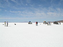
Salar de Uyuni is the world's largest salt flat, or playa, at over 10,000 square kilometres (3,900 sq mi) in area. It is in the Daniel Campos Province in Potosí in southwest Bolivia, near the crest of the Andes at an elevation of 3,656 m (11,995 ft) above sea level.

Puno is a department and region in southeastern Peru. It is the fifth largest department in Peru, after Cuzco, Madre de Dios, Ucayali, and Loreto. It is bordered by Bolivia on the east, the departments of Madre de Dios on the north, Cusco and Arequipa on the west, Moquegua on the southwest, and Tacna on the south. Its capital is the city of Puno, which is located on Lake Titicaca in the geographical region known as the Altiplano or high sierra.

The Altiplano, Collao or Andean Plateau, in west-central South America, is the most extensive high plateau on Earth outside Tibet. The plateau is located at the latitude of the widest part of the north–south-trending Andes. The bulk of the Altiplano lies in Bolivia, but its northern parts lie in Peru, and its southwestern fringes lie in Chile.

Copacabana is the main Bolivian town on the shore of Lake Titicaca. The town has a large 16th-century shrine, the Basilica of Our Lady of Copacabana, dedicated to Our Lady of Copacabana, the patron saint of Bolivia. The town is a tourism destination in Bolivia. It is also known for its trout and quaint atmosphere. Built between Mount Calvario and Mount Niño Calvario, the town has approximately 6,000 inhabitants. Copacabana's religious celebrations, cultural heritage and traditional festivals are well known throughout Bolivia. Boats leave for Isla del Sol, the sacred Inca island, from Copacabana. Copacabana is served by Copacabana Airport.

Uyuni is a city in the southwest of Bolivia.

Franz Tamayo is a province in the Bolivian department of La Paz. It lies in the western part of the nation, and includes the Ulla Ulla National Reserve - which today is part of the Apolobamba Integrated Management Natural Area - in the high Andean plain on the western border with Peru. Its capital is Apolo.

Isla del Sol is an island in the southern part of Lake Titicaca. It is part of Bolivia, and specifically part of the La Paz Department. Geographically, the terrain is harsh; it is a rocky, hilly island with many eucalyptus trees. There are no motor vehicles or paved roads on the island. The main economic activity of the approximately 800 families on the island is farming, with fishing and tourism augmenting the subsistence economy. Of the several villages, Yumani and Challapampa are the largest.
Isla Incahuasi, Inkawasi or Inka Wasi is a hilly and rocky outcrop of land and former island in Bolivia situated in the middle of Salar de Uyuni, the world's largest salt flat, at an elevation of 3,656 meters. It is located in the Potosí Department, Daniel Campos Province, Tahua Municipality, Yonza Canton.

Laguna Hedionda is a saline lake in the Nor Lípez Province, Potosí Department in Bolivia. It is notable for various migratory species of pink and white flamingos.
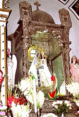
The Virgen de Copacabana is the patron saint of Bolivia. She is venerated in Bolivia during her feast day of 2 February, the day of the Purification of Mary, or feast of the Virgen de la Candelaria. She is also venerated on 5 August with her own liturgy and popular celebration.
The Gringo Trail refers to a string of the Latin American places most often visited by "gringos", Canadians, Americans, other budget travelers, vice tourists, backpackers, Anglo-European, Dutch, German heritage foreigners.

Iñaq Uyu, also called Aklla Wasi, is an archaeological site in Bolivia situated on the Isla de la Luna, an island of Lake Titicaca. It is located in the La Paz Department, Manco Kapac Province, Copacabana Municipality In Incan society, the societal structure was very rigid. Often those of belonging to the royal class structure did not mix with the lower classes.

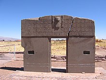
The Tiwanaku Polity was a Pre-Columbian polity in western Bolivia based in the southern Lake Titicaca Basin. Tiwanaku was one of the most significant Andean civilizations. Its influence extended into present-day Peru and Chile and lasted from around 600 to 1000 AD. Its capital was the monumental city of Tiwanaku, located at the center of the polity's core area in the southern Lake Titicaca Basin. This area has clear evidence for large-scale agricultural production on raised fields that probably supported the urban population of the capital. Researchers debate whether these fields were administered by a bureaucratic state (top-down) or through a federation of communities with local autonomy. Tiwanaku was once thought to be an expansive military empire, based mostly on comparisons to the later Inca Empire. However, recent research suggests that labelling Tiwanaku as an empire or even different varieties of a state may even be misleading. Tiwanaku is missing a number of features used to define these types of polities: there is no defensive architecture at any Tiwanaku site or changes in weapon technology, there are no princely burials or other evidence of a ruling dynasty or a formal social hierarchy, no evidence of state-maintained roads or outposts, and no markets.

Lake Tauca is a former lake in the Altiplano of Bolivia. It is also known as Lake Pocoyu for its constituent lakes: Lake Poopó, Salar de Coipasa and Salar de Uyuni. The lake covered large parts of the southern Altiplano between the Eastern Cordillera and the Western Cordillera, covering an estimated 48,000 to 80,000 square kilometres of the basins of present-day Lake Poopó and the Salars of Uyuni, Coipasa and adjacent basins. Water levels varied, possibly reaching 3,800 metres (12,500 ft) in altitude. The lake was saline. The lake received water from Lake Titicaca, but whether this contributed most of Tauca's water or only a small amount is controversial; the quantity was sufficient to influence the local climate and depress the underlying terrain with its weight. Diatoms, plants and animals developed in the lake, sometimes forming reef knolls.

The architecture of Bolivia is closely related to its history, culture and religion. Bolivian architecture has been constantly changing and progressing over time. Subject to terrain and high altitudes, most of Bolivia's Pre-Columbian buildings were built for housing, mainly influenced by Bolivian indigenous culture. The arrival of Spanish settlers brought many European-style buildings, and the Spaniards began planning to build big cities. After Independence, the architectural style became Neoclassical and many churches and government buildings were built. In modern Bolivia, like many countries, skyscrapers and post-modern buildings dominate, and of course there are special styles of architecture to attract tourists and build.