La Paz, officially known as Nuestra Señora de La Paz, is the de facto capital of Bolivia and is the seat of government of the Plurinational State of Bolivia. With an estimated 816,044 residents as of 2020, La Paz is the third-most populous city in Bolivia. Its metropolitan area, which is formed by La Paz, El Alto, Achocalla, Viacha, and Mecapaca makes up the second most populous urban area in Bolivia, with a population of 2.2 million, after Santa Cruz de la Sierra with a population of 2.3 million. It is also the capital of the La Paz Department.

A shrine to the Virgin Mary, or Marian shrine, is a shrine marking an apparition or other miracle ascribed to the Blessed Virgin Mary, or a site on which is centered a historically strong Marian devotion. Such locales are often the destinations of Christian pilgrimages.

Lake Titicaca is a large freshwater lake in the Andes mountains on the border of Bolivia and Peru. It is often called the highest navigable lake in the world. By both the volume of water and surface area, Titicaca is the largest lake in South America.
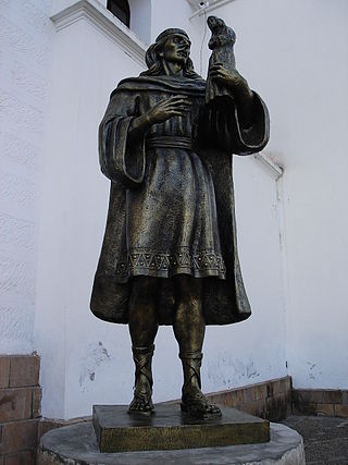
The Aymara or Aimara people are an indigenous people in the Andes and Altiplano regions of South America; about 2.3 million live in northwest Argentina, Bolivia, Chile, and Peru. Their ancestors lived in the region for many centuries before becoming a subject people of the Inca in the late 15th or early 16th century, and later of the Spanish in the 16th century. With the Spanish-American wars of independence (1810–1825), the Aymaras became subjects of the new nations of Bolivia and Peru. After the War of the Pacific (1879–1883), Chile annexed territory with the Aymara population.

Puno is a city in southeastern Peru, located on the shore of Lake Titicaca. It is the capital city of the Puno Region and the Puno Province with a population of approximately 140,839. The city was established in 1668 by viceroy Pedro Antonio Fernández de Castro as capital of the province of Paucarcolla with the name San Juan Bautista de Puno. The name was later changed to San Carlos de Puno, in honor of king Charles II of Spain. Puno has several churches dating back from the colonial period; they were built to service the Spanish population and evangelize the quechua.

Puno is a department and region in southeastern Peru. It is the fifth largest department in Peru, after Cuzco, Madre de Dios, Ucayali, and Loreto. It is bordered by Bolivia on the east, the departments of Madre de Dios on the north, Cusco and Arequipa on the west, Moquegua on the southwest, and Tacna on the south. Its capital is the city of Puno, which is located on Lake Titicaca in the geographical region known as the Altiplano or high sierra.

The Altiplano, Collao or Andean Plateau, in west-central South America, is the most extensive high plateau on Earth outside Tibet. The plateau is located at the latitude of the widest part of the north–south-trending Andes. The bulk of the Altiplano lies in Bolivia, but its northern parts lie in Peru, and its southwestern fringes lie in Chile.

The Uru or Uros are an indigenous people of Bolivia. They live on a still growing group of about 120 self-fashioned floating islands in Lake Titicaca near Puno. They form three main groups: the Uru-Chipaya, Uru-Murato, and Uru-Iruito. The Uru-Iruito still inhabit the Bolivian side of Lake Titicaca and the Desaguadero River.

Isla del Sol is an island in the southern part of Lake Titicaca. It is part of Bolivia, and specifically part of the La Paz Department. Geographically, the terrain is harsh; it is a rocky, hilly island with many eucalyptus trees. There are no motor vehicles or paved roads on the island. The main economic activity of the approximately 800 families on the island is farming, with fishing and tourism augmenting the subsistence economy. Of the several villages, Yumani and Challapampa are the largest.

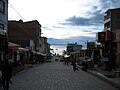
The Basilica of Our Lady of Copacabana is a 17th-century Spanish colonial shrine that houses the image of the Virgen de Copacabana. It is located in the town of Copacabana, Bolivia on the shores of Lake Titicaca near the Altiplano region. Our Lady of Copacabana is the patron saint of Bolivia.

The Gate of the Sun, also known as the Gateway of the Sun, is a monolith carved in the form of an arch or gateway at the site of Tiahuanaco by the Tiwanaku culture, an Andean civilization of Bolivia that thrived around Lake Titicaca in the Andes of western South America around 500-950 AD.

Christianity has a strong tradition of pilgrimages, both to sites relevant to the New Testament narrative and to sites associated with later saints or miracles.

The Virgin of Candelaria or Our Lady of Candle, popularly called La Morenita, celebrates the Virgin Mary on the island of Tenerife, one of the Canary Islands (Spain). The center of worship is located in the city of Candelaria in Tenerife. She is depicted as a Black Madonna. The "Royal Basilica Marian Shrine of Our Lady of Candelaria" is considered the main church dedicated to the Virgin Mary in the Canary Islands and she is the patron saint of the Canary Islands. Her feast is celebrated on February 2 and August 15, the patronal feast of the Canary Islands.
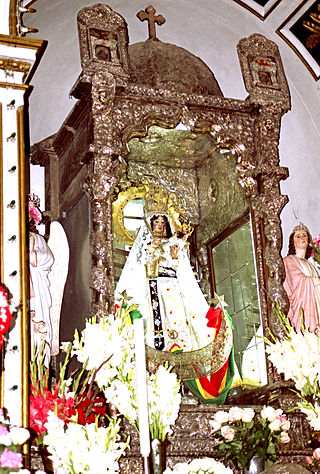
The Virgen de Copacabana is the patron saint of Bolivia. She is venerated in Bolivia during her feast day of 2 February, the day of the Purification of Mary, or feast of the Virgen de la Candelaria. She is also venerated on 5 August with her own liturgy and popular celebration.
Francisco Tito Yupanqui (1550–1616) was an indigenous sculptor of the Viceroyalty of Peru. He sculptured renowned Roman Catholic wood statues such as the Blessed Virgin Mary in what is now Bolivia, known as Our Lady of Candles, one of the most celebrated Marian images located at Lake Titicaca in Bolivia.

Andean Baroque is an artistic movement that appeared in colonial Peru between 1680 and 1780. It is located geographically between Arequipa and Lake Titicaca in what is now Peru, where rules over the highlands and spreads over the entire altiplano. From the Portuguese word barrueco meaning impure, mottled, flamboyant, daring, the most striking example of Andean Baroque art is in religious architecture, where criollo and indigenous craftsmen together gave it a unique character, as happened in the New Spanish Baroque.

Iñaq Uyu, also called Aklla Wasi, is an archaeological site in Bolivia situated on the Isla de la Luna, an island of Lake Titicaca. It is located in the La Paz Department, Manco Kapac Province, Copacabana Municipality In Incan society, the societal structure was very rigid. Often those of belonging to the royal class structure did not mix with the lower classes.

The Tiwanaku Polity was a Pre-Columbian polity in western Bolivia based in the southern Lake Titicaca Basin. Tiwanaku was one of the most significant Andean civilizations. Its influence extended into present-day Peru and Chile and lasted from around 600 to 1000 AD. Its capital was the monumental city of Tiwanaku, located at the center of the polity's core area in the southern Lake Titicaca Basin. This area has clear evidence for large-scale agricultural production on raised fields that probably supported the urban population of the capital. Researchers debate whether these fields were administered by a bureaucratic state (top-down) or through a federation of communities with local autonomy. Tiwanaku was once thought to be an expansive military empire, based mostly on comparisons to the later Inca Empire. However, recent research suggests that labelling Tiwanaku as an empire or even different varieties of a state may even be misleading. Tiwanaku is missing a number of features used to define these types of polities: there is no defensive architecture at any Tiwanaku site or changes in weapon technology, there are no princely burials or other evidence of a ruling dynasty or a formal social hierarchy, no evidence of state-maintained roads or outposts, and no markets.
Pre-Columbian Bolivia covers the historical period between 10,000 BCE, when the Upper Andes region was first populated and 1532, when Spanish conquistadors invaded Inca empire. The Andes region of Pre-Columbian South America was dominated by the Tiwanaku civilization until about 1200, when the regional kingdoms of the Aymara emerged as the most powerful of the ethnic groups living in the densely populated region surrounding Lake Titicaca. Power struggles continued until 1450, when the Incas incorporated upper Bolivia into their growing empire. Based in present-day Peru, the Incas instituted agricultural and mining practices that rivaled those put in place many years later by European conquerors. They also established a strong military force, and centralized political power. Despite their best efforts however, the Incas never completely controlled the nomadic tribes of the Bolivian lowlands, nor did they fully assimilate the Aymara kingdoms into their society. These internal divisions doomed the Inca Empire when European conquerors arrived.
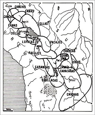
The Colla, Qolla or Qulla Kingdom was established in the northwestern basin of the Titicaca, one of the Aymara kingdoms that occupied part of the Collao plateau after the fall of Tiwanaku. In the mid-15th century the Collas possessed a vast territory, one of the largest of the Aymara kingdoms, which at the time the 9th Sapan Inka Pachakutiq Yupanqui Qhapaq the Intipchurin, conquered along with other political entities in the region.