Delhi has significant reliance on its transport infrastructure. The city has developed a highly efficient public transport system with the introduction of the Delhi Metro,[1] which is undergoing a rapid modernization and expansion since 2006.[2] There are 16.6 million registered vehicles in the city as of 30 June 2014, which is the highest in the world among all cities, most of which do not follow any pollution emission norm (within municipal limits), while the Delhi metropolitan region (NCR Delhi) has 11.2 million vehicles. Delhi and NCR lose nearly 42 crore (420 million) man-hours every month while commuting between home and office through public transport, due to the traffic congestion.[3] Therefore, serious efforts, including a number of transport infrastructure projects, are under way to encourage usage of public transport in the city.[4]
Prior to independence in the 1940s, public transport in the city was in private hands, with people relying mainly on tongas [citation needed] and the bus service of the 'Gwalior Transport Company' and 'Northern India Transport Company'.[5] But with the growing city, it soon proved inadequate, thus Delhi Transport Corporation (DTC) bus system was established in May 1948. The next big leap in city transport was the opening of Delhi Metro, a rapid transit system in 2002.
Overview
Public transport in the metropolis includes the Delhi Metro, the Delhi Transport Corporation (DTC) and DIMTS (Delhi Integrated Multi Modal Transit System) bus system, auto-rickshaws, cycle-rickshaws, e-rickshaws, Grameen Seva and taxis. With the introduction of Delhi Metro, a rail-based mass rapid transit system, rail-based transit systems have gained ground. Other means of transit include suburban railways, inter-state bus services and private taxis which can be rented for various purposes. However, buses continue to be the most popular means of transportation for intra-city travel, catering to about 60% of the total commuting requirements.[6]
Private vehicles account for 30%[citation needed] of the total demand for transport, while the rest of the demand is met largely by auto-rickshaws, taxis, rapid transit system and railways.
Indira Gandhi International Airport (IGI) serves Delhi for both domestic and international air connections, and is situated in the south-western corner of the city. In 2009–2010, IGI recorded a traffic of more than 25.01[7] million passengers, both Domestic and International.[8] Heavy air traffic has emphasised the need for a secondary airport, which is expected to be Taj International Airport near Greater Noida, alongside the Delhi-Agra highway.
The only international rail service in Delhi was the Samjhauta Express to Lahore,which was stopped in 2019 following a standoff. It is possible to change trains to board rail services to Bangladesh and Nepal which commence in other cities of India. For the future, a high-speed rail link is being considered that would link New Delhi with Kunming, China via Myanmar[9]
Intra-city Transport
Road transport
Roads in Delhi are maintained by the Municipal Corporation of Delhi, New Delhi Municipal Council, Delhi Cantonment Board, Public Works Department and Delhi Development Authority. At 1749km of road length per 100km2, Delhi has one of the highest road densities in India. Major roadways include the Ring Road and the Outer Ring Road, which had a traffic density of 110,000 vehicles per day in 2001. Total road length of Delhi was 28,508km including 388km of National Highways. Major road-based public transport facilities in Delhi are provided by DTC buses, auto-rickshaws, taxis and cycle-rickshaws.
Buses
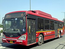
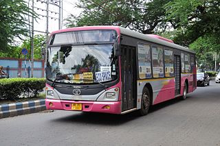
Delhi Transport Corporation (DTC) operates the world's largest fleet of CNG-powered buses. After Pune, Delhi was the second city in India to have an operational Bus rapid transit (BRT) system. However the BRT was dismantled in 2016 due to accidents and congestion.[10]
Delhi Integrated Multi-Modal Transits System
Delhi has one of India's largest bus transport systems. Buses are the most popular means of transport catering to about 60% of Delhi's total demand.[11] Buses are operated by the state-owned Delhi Transport Corporation (DTC), which owns largest fleet of Compressed Natural Gas (CNG)-fueled buses in the world, private Blueline bus operators and several chartered bus operators. It is mandatory for all private bus operators to acquire a permit from the State Transport Authority. The buses traverse various well-defined intra-city routes. Other than regular routes, buses also travel on Railway Special routes; Metro Feeder routes. Mudrika (Ring) and Bahri Mudrika (Outer Ring) routes along Ring and Outer-Ring road respectively are amongst the longest intra-city bus routes in the world. The DTC has started introducing air-conditioned buses and brand new low-floor buses (with floor height of 400mm and even higher on one third area as against 230mm available internationally.) on city streets to replace the conventional buses. A revamp plan is underway to improve bus-shelters in the city and to integrate GPS systems in DTC buses and bus stops so as to provide reliable information about bus arrivals. In 2007, after public uproar concerning the large number of accidents caused by privately owned Blueline buses, the Delhi government, under pressure from the Delhi High Court decided that all Blueline Buses shall be phased out and be eventually replaced by low floor buses of the state-owned DTC.[12] The Delhi Government has decided to expedite this process and will procure 6,600 low floor buses for the DTC by commonwealth games next year in mid 2020.[13]
As of May 2023, the fleet size of buses in Delhi is as follows:
including 100 e-buses and additional 380 buses operated by GNCTD[16][17]
Total
8121
Auto-rickshaws
The auto-rickshaws (popularly known as Auto) are an important and popular means of public transportation in Delhi, as they are cheaper than taxis. Hiring an Auto in Delhi is very tricky, as very few auto-drivers agree to standard meter charges. The typical method is to haggle for an agreeable rate.
Though easily available, taxis are not an integral part of Delhi public transport. There are over 113 registered taxis. The Indian Tourism Ministry and various private owners operate most taxis. The Tourism Ministry grants private companies permits to operate taxis. Recently, Radio Taxis have started to gain ground in Delhi. Some companies provide an on-call radio taxi service, which is slightly more expensive than conventional Black and Yellow taxis.
Cycle-rickshaws
Cycle-rickshaws are a popular mode of travel for short distance transits in the city. The pedal-powered rickshaws are easily available throughout the city and reckoned for being cheap and environment friendly. Often, tourists and citizens use them for joyrides, too. Of late, they have been phased out from the congested areas of Chandni Chowk because of their slow pace, which often leads to traffic snarls on the streets of Old Delhi. Still, they are the great source of public transport in Delhi.
Delhi-Gurgaon Expressway also connects both cities with the airport.
Inner Ring Road
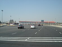
Inner Ring Road is one of the most important "state highways" in Delhi. It is a 51km long circular road, which connects Northern, eastern, Western and Southern areas in Delhi. Owing to more than 2 dozen grade-separators/flyovers, the road is almost signal-free. The road is generally 8-laned with a few bottlenecks at certain stretches, which are being removed. The road has already achieved its carrying capacity of 110000 vehicles per day and would require an addition of more lanes to fulfill needs of increasing traffic by 2011.
Outer Ring Road
Outer Ring Road is another major artery in Delhi. The road which was almost neglected till the early 2000s is now an important highway that links far-flung areas of Delhi. The road is 6-8 lane and has grade-separators and a large number are under construction as a part of project to make the artery signal free. The road along with the ring road forms a ring which intersects all the National Highways passing through Delhi.
Expressways and National Highways
The 32-lane toll gate at National Highway 48 was the largest in Asia and third largest in the world until it was dismantled in June 2015
Delhi is connected by NH 1, NH 2, NH 8, NH 10 and NH 24. It also has three expressways (six- and eight-lane) that connect it with its suburbs. Delhi–Gurgaon Expressway connects Delhi with one of its financial hubs, Gurgaon, DND Flyway connects Delhi with its other financial hub, Noida and Delhi–Faridabad Skyway which connects Faridabad, major suburb to Delhi. Four more expressways are also planned.
The DND Flyway
Noida–Greater Noida Expressway connects Noida with Greater Noida, which is an upcoming financial and commercial hub and is also to have a new Jewar International Airport. A 135.6-km long Western Peripheral Expressway, also known as the Kundli–Manesar–Palwal Expressway, which became operational on 19 November 2018, will relieve Delhi of the congestion of heavy night traffic and will act as a bypass for the night vehicles.
NH 24 or Ghaziabad Road is a four-lane national highway which connects Delhi to Lucknow via Ghaziabad. As the Commonwealth Village is located close by Yamuna bridge on this highway, underpasses and flyover being built will help facilitate traffic between the eastern areas of Delhi/ Western UP and the rest of the city.
Rail transport
Rail based transport in the city has started to gain popularity with the introduction of Delhi Metro. Ring-Railway, which runs parallel to the Ring-Road system is another rail-based intra-city transport facility in Delhi.
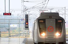
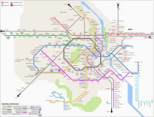
The Delhi Metro is being built in phases. Rapid increase of population coupled with large-scale immigration due to high economic growth has resulted in ever increasing demand for better transport, putting excessive pressure on the city's existent transport infrastructure. Like many other cities in the developing world, the city faces acute transport management problems leading to air pollution, congestion and resultant loss of productivity. In order to meet the transportation demand in Delhi, the State and Union government started the construction of a Mass Rapid Transit system, known as Delhi Metro in 1998. The project started commercial operations on 25 December 2002 between Shahdara and Tis Hazari) on the Red Line. It has set performance and efficiency standards and is continuously expanding. As of January 2022, the network consists of nine colour-coded regular lines along with the faster Airport Express line, with a total length of 348.12 kilometres (216.31mi)[19] serving 254 stations.[19] The system has a mix of underground, at-grade, and elevated stations using both broad-gauge and standard-gauge.[20] Phases III (112km) and IV (108.5km) will be completed by 2018 and 2025 respectively, with the network totaling 413.8km, making it longer than the London Underground.
Phase I consisted of 58 stations and 65.0km (40.4mi) of route length,[21] of which 13.0km (8.1mi) is underground and 52.1km (32.4mi) surface or elevated. The inauguration of the Dwarka–Barakhamba Road corridor of the Blue Line marked the completion of Phase I in October 2006.[22]
Phase II of the network consists of 124.6km (77.4mi) of route length and 85 stations,[21] and is fully completed, with the first section opened in June 2008 and the last line opened in August 2011.[23]
Phase-III has 28 underground stations, 2 new lines and 11 route extensions, totaling 167.27km (103.94mi), with a cost of ₹350 billion (US$4.4billion) and having an expected completion date of mid 2019. Phase IV (113.2km or 70.3mi) is planned to be completed by 2025.[24]
Delhi Metro lines that operate as of January 2022:
Ring railway is a 35-kilometre circular railway network in Delhi that runs parallel to the Ring Road. It was laid back in 1975 primarily to service freight trains that could bypass the crowded and passenger-heavy Old Delhi and New Delhi railway stations. The network was upgraded for the 1982 Asian Games with the introduction of 24 additional services. Its circular route is 35km (22mi) long, which the trains takes 90–120 minutes to complete, both clockwise and anti-clockwise, via the Hazrat Nizamuddin Railway Station. The ring railway service was quite popular through the 80s and 90s when Delhi's transport infrastructure was just gathering pace, but since then, with the rapid expansion of the Delhi Metro coupled with an extensive bus network, the ring railway has remained neglected by the city as well as the Railways. On average, only 3700 passengers take the trains every day. The biggest reason for the failure of the railway is a lack of a feeder network, such as approach roads and feeder buses to the stations. The stations are situated at remote locations and are difficult to access by passengers. There is also a problem of security as many stations have been encroached. The trains on this network also run behind schedule most of the time. The network is now utilized as a freight corridor and limited passenger train services are available during peak hours.[27][28][29]
Inter-state transport
Railway connectivity
Delhi is connected to whole of the nation through Indian Railways vast network. New Delhi Railway Station which is one of the most busiest stations in Indian Railway system serves as headquarters of Northern Railways. A large load of inter-state transport is borne by railways. A large number of local passenger trains connect Delhi to its sub-urban areas and thus provide convenient travel for daily commuters. Railways also share a large amount of freight traffic in Delhi.
Train Services
Regular train services available from railway stations in the city. The services are extended to all the states in the country. Services are provided by the national railway operator Indian Railways. The 5 railway stations in the city are:
The city is believed to have the highest road density in the country and is well connected to the rest of the nation through five major national highways, namely NH 1, NH 2, NH 8, NH 10 and NH 24. The highways around city are being upgraded into expressways with ultra-modern facilities.
Bus services
Regular bus services are available from interstate bus terminals in the city. The services are extended to all the northern states and the neighbouring areas of Delhi. Services are provided by state transport corporations and several private operators.
Aerocity Inter State Bus Terminus (Aerocity ISBT), adjacent to the Aerocity Metro Interchange Station near Terminal-1 of IGI in South Delhi, proposed in 2023.[31]
Airports
Indira Gandhi International Airport (IGI) serves Delhi for both domestic and international connections, and is situated in the southwestern corner of the city, alongside Delhi-Gurgaon Expressway. In the year 2015–16, IGI recorded a traffic of over 48 million passengers.[32] Being the busiest airport in the South Asian region, IGI airport has three terminals - Terminal 1 & Terminal 2 for domestic operations only and Terminal 3 - with mixed use i.e. primary International and the rest of the domestic operations(Vistara and Air India) - in addition of T1 & T2[33]
The airport was and still witnessing massive expansion and modernisation by a consortium led by GMR Infra. The new Terminal T3 was inaugurated in 2010 in line of the historic Commonwealth Games being held and Delhi is today India's only city to have an airport of this size. Terminals 4, 5 and 6 will be built in a phased manner. By 2024, airport will have four runways and will handle more than 100 million passengers per year.[34]
Hindon Domestic Airport in Ghaziabad was inaugurated by Prime Minister Narendra Modi as the second airport for the Delhi-NCR Region on the 8 March 2019.[35]
Apart from the expanded IGI airport, Delhi might also receive a second international airport by 2024. The airport, being named as Taj International Aviation Hub, is proposed to be located in Jewar in Greater Noida. It would be around 75km from IGI airport.
East-west connectivity bridges
Yamuna bridges in Delhi
Signature Bridge on Yamuna river is the tallest structure in Delhi
The total length of the Yamuna inside Delhi is 22km from the Wazirabad barrage to the Okhla barrage. This stretch of the river has 14 bridges (nine of them for road traffic), including those built by Delhi Metro (4) and Indian Railways (1). 4 bridges are under construction — 1 for road traffic and 3 for rail traffic.[36][37][38]
This article needs to be updated. Please help update this article to reflect recent events or newly available information.(September 2023)
There are many transport infrastructure projects underway in Delhi. Most had their deadlines set in late 2009 and early 2010, just before the 2010 Commonwealth Games. As of 2023, most of them have been completed. They are listed below -
Rail
Upgrading of New Delhi and Old Delhi railway stations of Northern Railways.
Delhi metro has new line of super-fast Delhi Airport Express Line having maximum speed of 135km/h line to connect to IGI Airport.
Reintroducing Trams in the Chandni Chowk and Red Fort areas of the city.[41][42]
Anand Vihar Railway Terminal to reduce the train loads over Old Delhi Station and New Delhi Railway Station. Besides that the station will also serve the densely populated Eastern part of Delhi, along with the neighbouring suburbs of Ghaziabad and Noida.
Two upcoming bridges over Yamuna will connect Faridabad to Noida and Greater Noida. One of the bridges would connect Faridabad-Noida-Ghaziabad (FNG) expressway from Noida's Sector 150 to National Highway 1 in Faridabad. The other bridge is proposed to link Noida's Sector 168 with Faridabad's Badoli village (Near Bypass Road)[43] Government has already approved construction of the road connecting Faridabad and Greater Noida that will improve the connectivity with clearances received from both Haryana and Uttar Pradesh Governments[44] The much-awaited FNG (Faridabad-Noida-Ghaziabad Expressway) is finally coming on track and will provide fast connectivity to daily commuters of the area once complete; apart from this, it is also emerging as an excellent stretch for real estate development. FNG Expressway is around 56km long with 19.9km in Noida–Greater Noida region, 8km in Ghaziabad, while the rest 28.1km is in the Faridabad region, especially the developing sectors of Neharpar Faridabad or Greater Faridabad. According to the plan, FNG from Noida side will become operational in the next 14 months while it would take three years for the whole stretch to become fully operational.[45] The completed expressway designed by IIT-Roorkee will offer commuters direct connectivity between Noida and Greater Faridabad[46]
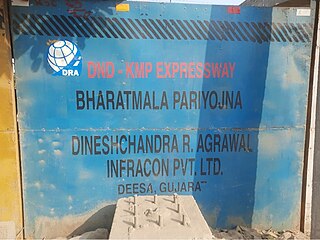
DND–KMP Expressway project has been approved in March 2019 which will connect DND Flyway at Maharani Bagh, Delhi to Faridabad bypass road near Badarpur border. According to Public Works Department officials, the bypass will connect the DND Flyway, cutting across the Agra Canal along the Yamuna, which runs perpendicular to Sarita Vihar and ends near Badarpur border, which further connects to Faridabad. "Commuters heading from east Delhi, South Delhi and Noida to Faridabad will be able to avoid the road to Ashram Chowk completely and that will help de-congest the area for local users. The estimated cost of the project is INR 3,580 crores and will be completed in three phases. In the first phase, the stretch from Maharani Bagh (at DND Flyway) to Kalindi Kunj will be completed. In the second phase, the stretch from Kalindi Kunj to Faridabad will see completion. The third phase will be from Sector-62/65 dividing road in Faridabad to KMP Expressway interchange near Sohna."[47] The bypass will dramatically reduce travel time between Delhi and Faridabad as it will serve as an alternative to Mathura Road. Unified Traffic and Transportation Infrastructure (Planning and Engineering) Centre gave the Public Works Department its consent to move ahead after Lieutenant-Governor Najeeb Jung gave the approval to the project.
Air
Revamp of IGI Airport is underway to improve its infrastructure, passenger capacity and efficiency.
Jewar Airport in Gautam Budhh Nagar district will start operations in 2025.
Union Civil Aviation Minister Ashok Gajapathi Raju inaugurated the Rohini Heliport on February 28, 2017.[48]
Delhi Traffic Police transport helpline
Owing to a large number of complaints from consumers, the Delhi Government in association with Delhi Traffic Police runs a staffed transport helpline which can be reached at 011-23010101 while dialing from within the city. Citizens can make traffic related complaints and suggestions. One can also report traffic violations observed and misbehavior/refusal/overcharging by autorickshaws, buses and taxis.[49]
↑ "Chapter 12: Transport"(PDF). Economic Survey of Delhi, 2005–2006. Planning Department, Government of National Capital Territory of Delhi. pp.130–146. Archived from the original(PDF) on 16 January 2007. Retrieved 21 December 2006.
↑ "Construction ban extended till Nov 21, Metro projects among those exempted". Hindustan Times. 18 November 2021. Retrieved 16 December 2021. Among important railway projects in the city where work will continue is construction of the New Yamuna bridge – being built parallel to the Old Yamuna bridge (Loha Pul). The new structure was set to be completed by December 2020, but COVID-19 delayed work.
Transport in India consists of transport by land, water and air. Road transport is the primary mode of transport for most Indian citizens, and India's road transport systems are among the most heavily used in the world.
Indira Gandhi International Airport is the primary international airport serving Delhi, the capital of India, and the National Capital Region (NCR). The airport, spread over an area of 5,106 acres (2,066 ha), is situated in Palam, Delhi, 15 km (9.3 mi) southwest of the New Delhi Railway Station and 16 km (9.9 mi) from New Delhi city centre. Named after Indira Gandhi (1917–1984), the former Prime Minister of India, it is the busiest airport of India in terms of passenger traffic since 2009. It is also the busiest airport in the country in terms of cargo traffic. In the financial year of 2020, the airport handled 6.73 crore passengers, the highest ever in the airport's history. As of 2022, it is the seventh busiest airport in the world, as per the latest rankings issued by the UK-based air consultancy firm, OAG. It is the second busiest airport in the world by seating capacity, having a seating capacity of over 36 lakh seats, and the busiest airport in Asia by passenger traffic, handling over 3.7 crore passengers in 2021.
Noida, short for New Okhla Industrial Development Authority, is a city located in Gautam Buddha Nagar district of the Indian state of Uttar Pradesh. Noida is a satellite city of Delhi and is a part of the National Capital Region. As per provisional reports of Census of India, the population of Noida in 2011 was 642,381. The city is managed by New Okhla Industrial Development Authority (NOIDA). The district's administrative headquarters are in the nearby city of Greater Noida.
Hyderabad, the capital and largest city of Telangana, features a growing transportation infrastructure that includes a network of roads, railways, and a developing rapid transit system. These transportation systems play a crucial role in connecting the city's residents and facilitating efficient travel within Hyderabad and its surrounding areas. Furthermore, Hyderabad serves as a significant center for transportation and logistics, playing a crucial role in facilitating the seamless movement of goods and services within the state.
The transport system of Kolkata, a city in India, is a mix of modern mass rapid transport and old transport modalities like rickshaws. Kolkata is connected to the rest of India by the National Highways, the extensive network of the Indian Railways, National Waterways and by air. The most traffic to Northeast India route is via Kolkata.
Noida International Airport, also known as Jewar Airport, is an upcoming international airport being constructed near Jewar in Gautam Buddha Nagar District, Uttar Pradesh in India, which will serve the National Capital Region (NCR). The airport is situated in the new planned YEIDA city.
Delhi, a major metropolitan region of India, is connected to various parts of country through several national highways and expressways. All the highways and expressways from Delhi lead to Haryana or Uttar Pradesh and continue from there.
The Western Peripheral Expressway (WPE) or Kundli–Manesar–Palwal Expressway, is an operational 6-lane, 135.6 km (84.3 mi)-long Expressway in the Haryana state of India. Along with the Eastern Peripheral Expressway, the Western Peripheral Expressway is expected to divert more than 50,000 heavy vehicles away from Delhi, which will help to maintain good air quality in Delhi. Western Peripheral Expressway along with Eastern Peripheral Expressway completes the largest Ring Road around Delhi. There are 10 tolled entries and exits, from north to south - Kundli, Kharkhoda, Bahadurgarh, Badli, Fartukhnagar, Panchgaon, Manesar, Taoru, Sohna & Palwal. Toll rate notified in December 2018 is INR1.35 per km for cars, INR2.18 per km for light motor vehicles, INR4.98 per km for trucks and buses, and two wheelers are not permitted on the expressway.
Yamuna Expressway is a 6-lane wide and 165.5 km (102.8 mi) long access-controlled expressway in the Indian state of Uttar Pradesh. It is presently India's 6th longest expressway and connects Greater Noida with Agra. It was built to de-congest the older Delhi–Agra national highway (NH-2) or Mathura Road.
Sarita Vihar is a posh residential colony situated in South East Delhi, India. It is near the Kalindi Kunj- Noida Toll bridge or GD Birla Marg-Road 13A which connects the district to Noida.The area is situated close to Uttar pradesh border. It is believed that the site was primarily chosen as the construction site for the Games Village of the 1982 Asian Games, however on the insistence of the late Prime Minister Rajiv Gandhi, the plan was changed to convert it into an upscale residential housing locality. In 2013, it was awarded the "Greenest Colony in Delhi" tag by the then Chief Minister of Delhi, Ms. Sheila Dikshit, credited to the efforts of its RWA members who have aggressively worked towards improving the state of parks and green spots in the locality.
The Botanical Garden is an interchange metro station in Noida between the Blue Line and Magenta Line of the Delhi Metro. It serves as one of the terminal stations of the Magenta line.
The Delhi Metro is a mass rapid transit (MRT) system which serves Delhi and its adjoining satellite cities, such as Ghaziabad, Faridabad, Gurugram, Noida and Bahadurgarh, in the National Capital Region of India. The system consists of 10 colour-coded lines serving 256 stations, with a total length of 350.42 kilometres (217.74 mi). It is India's largest and busiest metro rail system and the second-oldest, after the Kolkata Metro. The metro has a mix of underground, at-grade, and elevated stations using broad-gauge and standard-gauge tracks. The metro makes over 4,300 trips daily.
Badarpur is a historical town situated in the South East Delhi district of Delhi, India. The area of Badarpur encompasses both an NTPC thermal power station and an ancient village known as Badarpur village.
Kishangarh is an Urban village. The Village is located near Vasant Kunj in South West Delhi district of Delhi, India, on the hills of Aravali, between Mehrauli and Vasant Kunj. One extreme of Kishangarh is around 4 km from Qutub Minar in historic Mehrauli area. The other extreme is approximately 7.5 km from the Indira Gandhi International Airport. Munirka is about 5 km, where the Aruna Asaf Ali Marg, connecting the main Vasant Kunj Marg with the Outer Ring Road forms its western boundary.
Bijwasan railway station, on Delhi-Jaipur line lies immediate southwest of Delhi's main airport the IGI Airport, in Bijwasan in South Delhi in India. The station, part of Delhi Suburban Railway, is being upgraded to the world class regional multimodal interchange for the IGI airport by 2024. It will connect to the Haryana Orbital Rail Corridor in south at Patli railway station.
The Delhi–Mumbai Expressway is a 1,350 km long, 8-lane wide under-construction access-controlled expressway connecting India's national capital New Delhi to its financial capital Mumbai. The foundation stone for the project was laid by union minister Nitin Gadkari in the presence of Sushma Swaraj and Arun Jaitley on 8 March 2019. The total project value including the land acquisition cost is around ₹1,00,000 crores. An additional 31 km long spur will also be constructed by the NHAI from Noida International Airport in Jewar to Sector-65, Faridabad on this expressway.
DND–Faridabad–KMP Expressway or NH-148NA is a 59 km long, 6-lane wide access-controlled expressway in Delhi NCR, India. It connects the junction of DND Flyway and Ring Road at Maharani Bagh in Delhi with KMP Expressway at Khalilpur, Nuh district in Haryana. The NH-148NA is a spur (branch) of Delhi–Mumbai Expressway project. This expressway will have an additional 31 km long spur link from Sector-65, Faridabad bypass to Jewar Airport.
Haryana Orbital Rail Corridor (HORC), with target completion by 31 March 2025, is an under construction twin-track 121.7-kilometre (75.6 mi)-km long, 160 km per hour high-speed, railway project in Haryana state of India, which will run around along the Western Peripheral Expressway (WPE) on the western side of Delhi.
Madanpur Khadar is an urban village in South East district of Delhi. It is located on Delhi-UP Border and is an 800 years old village, named after Thakur Madan Singh Chauhan. The term Khadar is attached to the village’s name because it is situated on the banks of Yamuna river. It was declared as an urban village by the administrative authorities under Delhi Metropolitan Council in 1966.
Urban Extension Road-II or NH-344M is an upcoming 75.7 km long, 6 lanes & 6 lanes wide access-controlled expressway in Delhi NCR, India. It would start from National Highway 44 at Alipur then passes from Rohini, Mundka, Najafgarh, Dwarka and end at Delhi–Gurgaon Expressway on National Highway 48 near Mahipalpur. Its main route forms a semicircle on the western side of Delhi, additionally it has two side spurs - one from Bawana in Northwest Delhi to Sonipat in Bawana's North and second in west Delhi from between Tikri border & Najafgarh to NH9 Bahadurgarh south bypass. Delhi NCT has 4 concentric ring roads around it - namely Inner Ring Road; Outer Ring Road; third ring outside it formed by the combination of UER-II & Chilla-Okhla Expressway, and fourth ring formed by the combination of part of Dwarka Expressway & Gurugaon-Ghata Expressway, Gurgaon-Sohna Elevated Corridor Expressway, Sohna-Faridabad section of Delhi-Mumbai Expressway, Faridabad–Noida–Ghaziabad Expressway (FNG), Ghaziabad-Narela Expressway (planned) and Rai-Narela-Bahadurgarh-Gurgaon Expressway. Outside these ring roads, NCR region will have 3 Regional Circular Expressways and 3 Zonal Circular Expressways (ZCE).
This page is based on this Wikipedia article Text is available under the CC BY-SA 4.0 license; additional terms may apply. Images, videos and audio are available under their respective licenses.