Meteorological history | |
---|---|
Formed | September 2,2011 |
Extratropical | September 5 |
Dissipated | September 7,2011 |
Tropical storm | |
1-minute sustained (SSHWS/NWS) | |
Highest winds | 60 mph (95 km/h) |
Lowest pressure | 986 mbar (hPa);29.12 inHg |
Overall effects | |
Fatalities | 18 total |
Damage | $2.8 billion (2011 USD) |
Areas affected | United States Gulf Coast and Eastern United States |
IBTrACS / [1] | |
Part of the 2011 Atlantic hurricane season |
Tropical Storm Lee was the thirteenth named storm and fifteenth system overall of the 2011 Atlantic hurricane season,developing from a broad tropical disturbance over the Gulf on September 2. It was designated as Tropical Storm Lee the next day. Prior to 2020,when Marco formed on August 22,Lee was tied with 2005's Maria as the earliest-forming 13th Atlantic tropical storm. [2] The system was rather large,and due to drifting,Lee brought flash flooding to the Gulf Coast. [3] Flooding associated with the rains caused significant property damage in the areas,with drowning deaths reported in both Mississippi and Georgia. [4] Elsewhere,the storm helped spread wildfires that destroyed homes and killed two people in Texas,and a traffic accident in Alabama resulted in one death. Rough surf offshore drowned one person in each of these states. After becoming extratropical,Lee caused historic flooding in Pennsylvania,New York,and Canada,mainly Quebec and Ontario.
Lee was the first subtropical or tropical storm to make landfall in Louisiana since Hurricane Gustav in 2008. Its total damage was estimated to be around $2.8 billion. [5]
In late August 2011, much of the western Caribbean came under the influence of abundant tropical moisture. [6] Combined with favorable upper diffluence, the moisture allowed for a perpetual area of disturbed weather to form; this, in return, contributed to the genesis of a weak tropical wave, or an elongated low-pressure feature at the lower levels of the atmosphere. [7] The wave initiated a more-or-less westward, then west-northwestward drift across the Yucatán Peninsula toward the Gulf of Mexico, although it remained largely disorganized while doing so. [8] [9] After arriving in the gulf on August 31, the system failed to develop much under initially high wind shear; however, the National Hurricane Center forecast some potential for the formation of a tropical cyclone in a day or two. [10] Strong convection increased mainly to its east during the next day, [11] and by 23:00 UTC, data from a reconnaissance aircraft confirmed the presence of a closed circulation center. At this point, the system was considered sufficiently organized to be upgraded to a tropical depression, with its center located 255 mi (360 km) to the southwest of the mouth of the Mississippi River. [12]
Situated within an area of weak steering currents, the depression remained nearly stationary during the initial stages of its existence. [13] It exhibited a poor organization at the time; the circulation remained elongated, with a broad center of light winds removed from the sheared convective mass. [12] [14] Over the course of September 2 the convection began to deepen over its eastern portion, [15] which later translated into an increase in the winds. Based on this increase in strength, the depression was upgraded to Tropical Storm Lee at 18:00 UTC. [16] Lee meandered erratically north-northwestward to northward for the rest of the day, and with a small upper low advecting dry air into the circulation any deep convection over its western semicircle remained scarce during that time. [17] [18] By September 3, the storm sustained a large radius of maximum winds within the still elongated circulation; this unusual structure to purely tropical cyclones, combined with an overall hybrid appearance on satellite images, suggested Lee transitioned into a subtropical storm as it approached the Louisiana coast, similar to the transition of Tropical Storm Allison in 2001. [19]
Stalling off the coast of Louisiana, the storm's windfield continued to expand and increase in strength, though two separate low-level centers became evident within the exceedingly large circulation later that day. [20] Due to a large portion of circulation remaining over the warm waters of the Gulf of Mexico, Lee weakened more slowly than a typical tropical cyclone would as it moves inland. [21] Lee finally moved inland over south-central Louisiana on the morning of September 4 as a subtropical storm with winds of 45 mph (75 km/h). [22] By that evening, Lee had weakened to a tropical depression in operational estimates, due to land interaction and continental air being advected into the system. Lee had begun to interact with a strong upper-level trough (which would subsequently spawn Hurricane Nate in the Bay of Campeche a few days later) in the Mississippi Valley as it continued to move off to the east-northeast. [23] It was designated an extratropical low adjacent to the trough on the morning of September 5, while maintaining tropical storm-force winds according to post-analysis. [24] The extratropical remnants weakened further on September 6, as it entered northwestern Georgia. Early on September 7, at 00:00 UTC, the remnant low of Lee dissipated. [1] However, the storm's mid-level circulation persisted, developing a new triple-point low along its occluded front, which quickly dominated the storm. For the next several days, the new low made a large, counterclockwise loop over a portion of the Eastern United States, before dissipating on September 11, over western Tennessee. [25]
In advance of the storm, oil companies in the Gulf of Mexico ordered the evacuation of employees from offshore platforms as a safety precaution. [26] A tropical storm warning was posted from Pascagoula, Mississippi, westward to Sabine Pass, Texas, in response to Lee. [27] Early on September 3, the warning was extended to the Alabama–Florida border. In addition, a tropical storm watch was in place from the border eastward to Destin, Florida. [28]
Mayor Mitch Landrieu declared a state of emergency for all of New Orleans; officials accordingly ordered the closure of floodgates and the preparation of rescue boats across the city. [29] In Grand Isle, many residents headed out of town after officials issued voluntary evacuations, and boat owners secured their vessels. [30] Additionally, the Louisiana parishes of Terrebonne and Lafourche distributed sandbags at several coastal locations [31] after specialists forecast torrential rainfall and flash flood warnings were issued. [32]
Due to its unusually slow and erratic motion, Lee produced flooding rains across much of southern Louisiana. Headwinds from Lee fanned a large fire north in Natchitoches Parish; about 400 acres of land, including 10 adjacent homes and several buildings, were set ablaze and subsequently destroyed. [33] High winds also produced a storm surge that submerged parts of Slidell by up to 4 ft (1.2 m), inundating several homes. About 38,000 residences in New Orleans were left without power at one point, though only minor flooding occurred around the city. [34] Low-lying areas in adjacent parishes reported more significant effects; street flooding occurred in Plaquemines and St. Bernard Parishes, and floodwaters in Jefferson Parish prompted residents to evacuate. [35] Moving ashore in the latter parish near Lafitte, the storm caused heavy rainfall, leaving roughly 60 percent of the area inundated. [36]
In light of heavy rainfall forecast for coastal areas, much of southern Mississippi was under a flash flood watch until the passage of the storm. A state of emergency was ordered for Jackson County; local fire stations initiated the free distribution of sandbags, and the harbor was closed off to all transient vessels. [37] Similar preparations took place in Hancock County, where officials issued voluntary evacuations for low-lying areas. Rainfall totals in Waveland, MS measured 14.75 inches (375 mm). [38] Gulf Islands National Seashore ordered the immediate closure of its portions of the Mississippi–Alabama barrier islands, while its present visitors were instructed to leave. [39]
Across the southern state, prolonged inclement weather from Lee and its remnants resulted in widespread moderate and localized extensive flooding. Several roads were inundated in the coastal counties of Hancock, Jackson, and Harrison, with the latter two reporting considerable property damage due to the floods. [40] A potent tornado touched down in northern Harrison, leaving behind demolished trailers and downed trees and power lines throughout Saucier. [41] In Stone County, some structures including one church sustained wind damage during the storm; [40] officials further reported the worst of the winds were also attributed to a possible tornado, which uprooted trees and severely damaged one manufactured home. [42] Further inland, moderate street flooding also occurred in Rankin and Wilkinson counties, while more significant floods, as well as scattered power outages, took place in Hinds County. In Tishomingo County, a vehicle was caught in rushing waters while attempting to cross a flooded road; one person drowned, though its two other occupants were unharmed. [40]
With Lee tracking further inland, heavy precipitation up to 13 in (330 mm) fell across Alabama. [43] At the height of the storm, about 220,000 customers reportedly lost power due to snapped electricity poles and power lines. [44] It caused significant, albeit localized wind damage to structures across southern areas, in particular in and around Mobile and Baldwin Counties. Multiple properties sustained damage and two homes were demolished by the winds; throughout southern Mobile, dozens of downed trees caused additional disruptions. [45] Also in the county, one person was killed in a traffic accident related to the storm. [46] In Lillian, Baldwin, extreme winds suspected to be from a tornado ripped through suburban areas. A few homes sustained damaged in part due to uprooted trees, though no injuries were reported. [45] Off the coast of Fort Morgan, one person drowned due to high surf. [46] Additionally, the brisk winds blew piles of sand from local beaches onto adjacent city streets, [47] and rough seas swept ashore numerous tarballs. [48]
Despite bringing little rain to Texas, Lee produced gusts and rough surf along its coasts. Offshore Galveston, a man drowned after losing control of his bodyboard due to strong winds. [49] As Lee headed north inland over the Gulf Coast, high winds were reported as fueling up to 60 separate brush fires across Texas, which was suffering from exceptional drought conditions. [50] The largest of these occurred in Bastrop County just east of Austin, consuming roughly 34,000 acres; it forced thousands to evacuate and destroyed 1,554 homes. [51] In Gregg County, another fire burned down a home, which resulted in the deaths of two of its occupants. [50] The spreading fires burned nearly 118,500 acres (480 km²) of land, simultaneously demolishing an estimated 700 residences in a two-day period. [52]
Heavy rain from the remnants of Lee brought flooding to the Susquehanna River valley, dropping 10-12 inches of precipitation. [53] In the Binghamton area, record flooding was observed along the Susquehanna and Chenango Rivers. USGS river gauges recorded water levels as high as 17 ft above flood stage, topping previous record heights achieved in the Mid-Atlantic United States flood of 2006. [54] In some areas, such as Conklin, several residents had finished rebuilding from the 2006 floods only months before Lee hit.
Most municipalities in Greater Binghamton and the Penn-York Valley saw water levels top the levees, inundating several downtown areas along the river. Many of the locations under water had not flooded since the mid-1930s, due to the construction of levees. [55] Over 20,000 residents were forced to evacuate in Broome County, and downtown Binghamton was closed off. Residents who were downstream from the Forest Lake Dam and the Elk Lake Dam were evacuated. [56] The village of Owego was particularly hard-hit, with 95% of the community under water. [57] In the aftermath, several roads were closed, including Interstate 88, which was blocked by a mudslide, and NY Route 17.
Property damage far exceeded the flood of 2006, despite precautions taken in the wake of that natural disaster. Across eight counties in New York, an early tally estimated initial losses at $562.2 million. [58] In the Triple Cities urban core, over 7,000 properties were damaged. Damages in Broome County alone were estimated to be $513 million, while in Tioga County, estimated losses were $478 million. [59] Two deaths were blamed on the storm. [60]
To the east, regions already suffering the aftereffects of flooding from Hurricane Irene almost two weeks earlier had those problems aggravated by 2–4 inches (51–102 mm) of new rain on saturated ground and rivers still swollen. The Wallkill River crested at 5 feet (1.5 m) above flood stage in Ulster County, and the village of Washingtonville in Orange County to the south was isolated as it had been after Irene by the rising waters of Moodna Creek. The Orange County Government Center in Goshen, just reopened a day earlier, was closed indefinitely. Roads were closed, including exits on the New York State Thruway in the Mohawk Valley, and south of the Interstate 84 exit at Newburgh, the entire highway. Some businesses that had spent considerable time and money to reopen after Irene were once again flooded. A Petco flooded because of the tropical storm resulting in almost 100 animals drowning after a failed attempt to take them to safety. [61]
Flooding in Wilkes-Barre led to a mandatory evacuation on September 8 of all of the areas that were affected by the 1972 Hurricane Agnes floods. [62] The Susquehanna River reached a record high of 42.6 feet (13.0 m) in hard-hit Wilkes-Barre early on Friday, September 9. The levee system held in the northeastern Pennsylvania city. The river topped the 40.9 feet (12.5 m) level in flooding caused by Agnes. [63] Other towns in northeastern Pennsylvania, which were not protected by a levee system, encountered historic flooding. West Pittston, Pittston, Tunkhannock, Edwardsville, Plymouth Township, and Nanticoke were just a few areas affected. About 100,000 people were displaced. [64]
In Columbia County, the Bloomsburg Fair was forced to be cancelled for the first time in its 157-year history due to extensive damage to the fairgrounds [65]
On the border of Northumberland and Columbia Counties, the well-known amusement park Knoebels receives flooding in the park. The flood was close to the damages of Hurricane Agnes in 1972. The park received major damage, with almost all of its employees chipping in that week to help reopen. The majority of the park opened the following week. [66]
The prospect of flooding led Harrisburg to evacuate 10,000 people from low-lying areas of downtown. [67] The Pennsylvania Governor's Residence was evacuated due to rising floodwaters. [68] Lee caused the Susquehanna River to reach the third-worst flood stage in its history, and caused the Swatara Creek to reach its highest level ever. [69] One drowning bison at the ZooAmerica wildlife park in Hershey, Pennsylvania, was shot because it could not be rescued from floodwaters. Another bison drowned before it could be rescued. [70] The heavy rain caused a rockslide in the vicinity of the Conshohocken Curve, flooding near Belmont Avenue and a mudslide by Girard Avenue on the Schuylkill Expressway, a major artery into Philadelphia. [71]
In Sullivan County, the village of Sonestown was almost completely destroyed. A dam on Birch Creek in the village of Mildred collapsed, causing a large swath of damage along US Route 220.
The eastern part of Lycoming County sustained major flood damage associated with the remnants of Lee. The boroughs of Picture Rocks and Hughesville and village of Glen Mawr had to be evacuated due to flooding on Muncy Creek. [72] A bridge at the eastern end of Pennsylvania Route 973 over Loyalsock Creek collapsed on September 8. The Lycoming Valley Railroad bridge over Loyalsock Creek in Montoursville was heavily damaged by flooding, rendering it unusable. Heavy rain from the remnants of Tropical Storm Lee raised the creek "higher than anything we've seen in recorded history", according to a county official. [73] Replacing the destroyed PA 87 bridge and repairs to the damaged railroad bridge and Pennsylvania Route 87 were estimated to cost more than $25 million. [74]
In Dauphin County, damage totaled about $150 million. The storm destroyed 294 buildings and damaged another 2,234. In nearby Lebanon County, 2,212 homes sustained damage. [75] Damage in York County reached $2.9 million. [76]
Between 7 and 15 inches (180 and 380 mm) of rain fell in northwestern Lancaster County, the worst storm to strike the area since Hurricane Agnes in 1972. [77] The city of Lancaster received 7.76 inches (197 mm) of rain, while the boroughs of Elizabethtown and Mount Joy measured 15 inches (380 mm) of rain. [77] The rain swollen Chiques Creek ripped the five-ton Siegrist's Mill Covered Bridge, built in 1885, off its foundation and swept the bridge downstream. [77]
The National Weather Service reported 7.03 inches of rain in three hours at Ft. Belvoir, 5.47 inches in the Franconia area, and 6.57 inches in Reston. [78] Record rainfall resulted in the flooding of most creeks and waterways in suburban Northern Virginia, leading to four deaths, all by drowning. [79] In Fairfax County, Virginia, VDOT estimated up to $10 million of damage to roads and bridges. [80]
Tropical Storm Lee added to the rainfall from Hurricane Irene. The National Weather Service reported record 30-day total rainfalls in Prince George's County, Maryland, including 24.13 inches in Largo, 23.98 inches in Forestville, and 21.49 inches in Forest Heights. [78]
Tropical Storm Allison was a tropical storm that devastated southeast Texas in June of the 2001 Atlantic hurricane season. An arguable example of the "brown ocean effect", Allison lasted unusually long for a June storm, remaining tropical or subtropical for 16 days, most of which was when the storm was over land dumping torrential rainfall. The storm developed from a tropical wave in the northern Gulf of Mexico on June 4, 2001, and struck the upper Texas coast shortly thereafter. It drifted northward through the state, turned back to the south, and re-entered the Gulf of Mexico. The storm continued to the east-northeast, made landfall on Louisiana, then moved across the southeast United States and Mid-Atlantic. Allison was the first storm since Tropical Storm Frances in 1998 to strike the northern Texas coastline.
The 2002 Atlantic hurricane season was a near-average Atlantic hurricane season. It officially started on June 1, 2002, and ended on November 30, dates which conventionally limit the period of each year when most tropical cyclones develop in the Atlantic Ocean. The season produced fourteen tropical cyclones, of which twelve developed into named storms; four became hurricanes, and two attained major hurricane status. While the season's first cyclone did not develop until July 14, activity quickly picked up: eight storms developed in the month of September. It ended early however, with no tropical storms forming after October 6—a rare occurrence caused partly by El Niño conditions. The most intense hurricane of the season was Hurricane Isidore with a minimum central pressure of 934 mbar, although Hurricane Lili attained higher winds and peaked at Category 4 whereas Isidore only reached Category 3. However, Lili had a minimum central pressure of 938 mbar.
Tropical Storm Bonnie was a tropical storm that made landfall on Florida in August 2004. The second storm of the 2004 Atlantic hurricane season, Bonnie developed from a tropical wave on August 3 to the east of the Lesser Antilles. After moving through the islands, its fast forward motion caused it to dissipate. However, Bonnie later regenerated into a tropical storm near the Yucatán Peninsula. Bonnie attained its peak intensity with maximum 1-minute sustained winds of 65 miles per hour (105 km/h) and a minimum central pressure of 1,001 mbar on August 11 while located over the Gulf of Mexico. Afterwards, the storm turned to the northeast and hit Florida with winds of 45 miles per hour (72 km/h). The storm accelerated to the northeast and became an extratropical cyclone to the east of New Jersey. Bonnie was the first of five tropical systems in the 2004 season to make landfall in Florida, coming ashore the day before Hurricane Charley struck. Bonnie was also the second of a record eight storms to reach tropical storm strength during the month of August.
Hurricane Ivan was a large, long-lived, Cape Verde hurricane that caused widespread damage in the Caribbean and United States. The cyclone was the ninth named storm, the sixth hurricane and the fourth major hurricane of the active 2004 Atlantic hurricane season.
Hurricane Cindy was a tropical cyclone that briefly reached minimal hurricane strength in the Gulf of Mexico during July in the 2005 Atlantic hurricane season and made landfall in Louisiana. It was the third named storm and first hurricane of the season. Cindy was originally thought to have been a tropical storm at peak strength, but was upgraded to a Category 1 hurricane in the post-season analysis. Cindy formed on July 3 just east of the Yucatán Peninsula in the Caribbean Sea. The depression soon made landfall on the peninsula and weakened before reemerging in the Gulf of Mexico on July 4. The storm strengthened as it moved north becoming a hurricane just before making landfall near Grand Isle, Louisiana, on July 5. The storm weakened as it moved overland and became extratropical on July 7.
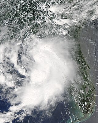
Tropical Storm Allison was a tropical cyclone that produced severe flooding in the southern United States. The second tropical cyclone and the first named storm of the 1989 Atlantic hurricane season, Allison formed on June 24 in the northwestern Gulf of Mexico. Development of Allison was a result of the interaction of a tropical wave and the remnants of Pacific hurricane Hurricane Cosme. It moved south and became a tropical storm on June 26. By June 27, Allison made landfall near Freeport, Texas. Allison quickly weakened to a tropical depression later that day, and transitioned into an extratropical cyclone on the following day. However, the storm's remnants persisted for another 10 days and meandered across the area, triggering flooding across the region, before dissipating on July 7.
Hurricane Gordon caused minor damage in the Eastern United States. The seventh named storm and fourth hurricane of the 2000 Atlantic hurricane season, Gordon developed in the extreme western Caribbean Sea from a tropical wave on September 14. Shortly thereafter, the depression moved inland over the Yucatán Peninsula and later emerged into the Gulf of Mexico on September 15. The depression began to quickly organize, and by early on September 16, it was upgraded to Tropical Storm Gordon. After becoming a tropical storm, Gordon continued to intensify and was reclassified as a hurricane about 24 hours later; eventually, the storm peaked as an 80 mph (130 km/h) Category 1 hurricane. However, southwesterly upper-level winds caused Gordon to weaken as it approached land, and it was downgraded to a tropical storm by late on September 17. At 0300 UTC on September 18, Gordon made landfall near Cedar Key, Florida as a strong tropical storm. After moving inland, Gordon rapidly weakened and had deteriorated to tropical depression status by nine hours later. Later that day, Gordon merged with a frontal boundary while centered over Georgia.
Tropical Storm Hanna was a moderately strong tropical storm that affected the Gulf Coast and Southeastern regions of the United States. The ninth tropical cyclone and eighth named storm of the 2002 Atlantic hurricane season, Hanna formed through the complex interaction of a surface trough, a tropical wave, and an upper-level low pressure system, a disturbance in the upper atmosphere. Designated a tropical depression at 0000 UTC on September 12, the storm remained disorganized throughout its duration, though it attained tropical storm status and a peak intensity of 1,001 mbar (29.6 inHg), with winds of 60 miles per hour (100 km/h). Hanna crossed extreme southeastern Louisiana, and made a second landfall along the Alabama–Mississippi border.
Tropical Storm Bill was a tropical storm that affected the Gulf Coast of the United States in the summer of 2003. The second storm of the 2003 Atlantic hurricane season, Bill developed from a tropical wave on June 29 to the north of the Yucatán Peninsula. It slowly organized as it moved northward, and reached a peak of 60 miles per hour (97 km/h) shortly before making landfall in south-central Louisiana. Bill quickly weakened over land, and as it accelerated to the northeast, moisture from the storm, combined with cold air from an approaching cold front, produced an outbreak of 34 tornadoes. Bill became extratropical on July 2, and was absorbed by the cold front later that day.
Tropical Storm Barry was a strong tropical storm that made landfall on the Florida Panhandle during August 2001. The third tropical cyclone and second named storm of the 2001 Atlantic hurricane season, Barry developed from a tropical wave that moved off the coast of Africa on July 24. The wave entered the Caribbean on July 29 and spawned a low-pressure area, which organized into Tropical Storm Barry on August 3. After fluctuations in intensity and track, the storm attained peak winds of 70 mph (110 km/h) over the Gulf of Mexico. Barry headed northward and moved ashore along the Gulf Coast before degenerating into a remnant low on August 7. On the next day, Barry's remnants dissipated over Missouri.
Tropical Storm Alberto was the first tropical storm of the 2006 Atlantic hurricane season. Forming on June 10 in the northwestern Caribbean, the storm moved generally to the north, reaching a maximum intensity of 70 mph (110 km/h) before weakening and moving ashore in the Big Bend area of Florida on June 13. Alberto then moved through eastern Georgia, North Carolina, and Virginia as a tropical depression before becoming extratropical on June 14.
Tropical Storm Dean was a short-lived storm that formed in late July 1995 and lasted into early August. It was the fourth named storm of the 1995 Atlantic hurricane season. It spent most of its life as a tropical depression, and briefly gained tropical storm status before its landfall on the Texas coast on July 30. After landfall, it dissipated over central Texas on August 2. The impacts from Dean were minimal, mainly due to heavy rain in Oklahoma and Texas that caused localized coastal and inland flooding. Two F0 Tornadoes touched down in Texas as a result of Dean's landfall. Also, Twenty families had to be evacuated in Chambers County, due to flooding in the area. One fatality was recorded as a result of flooding in Oklahoma. Several highways were flooded out in Oklahoma, which impeded travel in the state. In addition approximately $500,000 worth of damage was recorded in the aftermath of Dean.
Tropical Storm Hermine was the eighth tropical cyclone and named storm of the 1998 Atlantic hurricane season. Hermine developed from a tropical wave that emerged from the west coast of Africa on September 5. The wave moved westward across the Atlantic Ocean, and on entering the northwest Caribbean interacted with other weather systems. The resultant system was declared a tropical depression on September 17 in the central Gulf of Mexico. The storm meandered north slowly, and after being upgraded to a tropical storm made landfall on Louisiana, where it quickly deteriorated into a tropical depression again on September 20.
Hurricane Humberto was a Category 1 hurricane that formed and intensified faster than any other North Atlantic tropical cyclone on record, before landfall. The eighth named storm and third hurricane of the 2007 Atlantic hurricane season, Humberto developed on September 12, 2007, in the northwestern Gulf of Mexico. The tropical cyclone rapidly strengthened and struck High Island, Texas, with winds of about 90 mph (140 km/h) early on September 13. It steadily weakened after moving ashore, and on September 14, Humberto began dissipating over northwestern Georgia as it interacted with an approaching cold front.
Tropical Storm Edouard brought coastal and minor inland flooding to Louisiana and Texas in August 2008. The fifth tropical cyclone and fifth named storm of the hurricane season, Edouard developed from a trough in the northern Gulf of Mexico on August 3. After developing into a tropical depression, it gradually strengthened and was upgraded to Tropical Storm Edouard on August 4. However, northerly wind shear initially halted any further significant intensification and also caused the storm to struggle to maintain deep convection over the center. Edouard eventually intensified further and peaked as a strong tropical storm with winds of 65 mph (100 km/h) on August 5. Shortly thereafter, the storm made landfall near Gilchrist, Texas later that day. Edouard quickly weakened and was downgraded to tropical depression by early on August 6, six hours before degenerated into a remnant low pressure area.
Tropical Storm Claudette was the third named storm of the 2009 Atlantic hurricane season and the first tropical cyclone of 2009 to affect the United States. Forming out of a tropical wave and an upper-level low pressure system on August 16, Claudette quickly intensified into a tropical storm offshore south of Tallahassee, Florida. By the afternoon, the storm had attained winds of 60 mph (97 km/h) and steadily tracked towards the Florida Panhandle. Early on August 17, the center of Claudette made landfall on Santa Rosa Island. Several hours after landfall, the storm weakened to a tropical depression and the Hydrometeorological Prediction Center took over primary responsibility of the storm. Later on August 17, the final public advisory was issued on the system as it dissipated over Alabama.
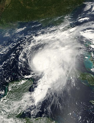
Hurricane Isaac was a deadly and destructive tropical cyclone that came ashore in the U.S. state of Louisiana during August 2012. The ninth named storm and fourth hurricane of the annual hurricane season, Isaac originated from a tropical wave that moved off the west coast of Africa on August 16. Tracking generally west, a broad area of low pressure developed along the wave axis the next day, and the disturbance developed into a tropical depression early on August 21 while several hundred miles east of the Lesser Antilles. The system intensified into a tropical storm shortly thereafter, but high wind shear initially prevented much change in strength.
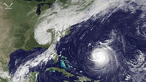
Hurricane Sally was a destructive and slow-moving Atlantic hurricane that was the first hurricane to make landfall in the U.S. state of Alabama since Ivan in 2004, coincidentally on the same date in the same place. The eighteenth named storm and seventh hurricane of the extremely active 2020 Atlantic hurricane season, Sally developed from an area of disturbed weather which was first monitored over the Bahamas on September 10. The system grew a broad area of low-pressure on September 11, and was designated as a tropical depression late that day. Early the next day, the depression made landfall at Key Biscayne and subsequently strengthened into Tropical Storm Sally that afternoon. Moderate northwesterly shear prevented significant intensification for the first two days, but convection continued to grow towards the center and Sally slowly intensified. On September 14, a center reformation into the center of the convection occurred, and data from a hurricane hunter reconnaissance aircraft showed that Sally had rapidly intensified into a strong Category 1 hurricane. However, an increase in wind shear and upwelling of colder waters halted the intensification and Sally weakened slightly on September 15 before turning slowly northeastward. Despite this increase in wind shear, it unexpectedly re-intensified, reaching Category 2 status early on September 16 before making landfall at peak intensity at 09:45 UTC on September 16, near Gulf Shores, Alabama, with maximum sustained winds of 110 mph (180 km/h) and a minimum central pressure of 965 millibars (28.5 inHg). The storm rapidly weakened after landfall before transitioning into an extratropical low at 12:00 UTC the next day. Sally's remnants lasted for another day as they moved off the coast of the Southeastern United States before being absorbed into another extratropical storm on September 18.
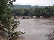
Tropical Storm Karen was a system that brought record-breaking rainfall and flooding to southeastern Pennsylvania and other Mid-Atlantic states in October 2013. The twelfth tropical cyclone and eleventh named storm of the well below-average 2013 Atlantic hurricane season, Karen originated from a tropical wave that departed from the west coast of Africa on September 16. After passing south of Jamaica and the Cayman Islands, the storm became a tropical cyclone to the northeast of the Yucatán Peninsula. The storm peaked shortly afterward, with 1-minute sustained winds of 65 mph (105 km/h). The storm triggered warnings along the Gulf Coast of the United States, but the storm ultimately degenerated into an open trough in the Gulf of Mexico without making landfall. The remnants of Karen then turned eastward and crossed Florida, before evolving into a nor'easter off the coast of North Carolina, stalling off the Delmarva Peninsula through October 12. The system weakened and drifted back southwestward towards Florida, dissipating off the coast of the state on October 15.
{{cite news}}
: |author=
has generic name (help)