Turlough (lake)

Last updated

A turlough (turloch or turlach in Irish [1] ) is a seasonal or periodic water body found mostly in limestone karst areas of Ireland, west of the River Shannon. The name comes from the Irish tur, meaning "dry", and loch, meaning "lake". The water bodies fill and empty with the changes in the level of the water table, usually being very low or empty during summer and autumn and full in the winter. As groundwater levels drop the water drains away underground through cracks in the karstic limestone. [2]

Contents

Turloughs are almost unique to Ireland, although there is one example in Wales, Pant-y-Llyn at Cernydd Carmel near Llandeilo. [3] [4] They are of great interest to many scientists: geomorphologists are interested in how turloughs were formed, hydrologists try to explain what makes turloughs flood, botanists study the unusual vegetation which covers the turlough floor, and zoologists study the animals associated with the turloughs.

The turlough at Carran, County Clare, Ireland. The water level is high following a spell of wet weather. (Late May, 2005) Carran Turlough.jpg
The turlough at Carran, County Clare, Ireland. The water level is high following a spell of wet weather. (Late May, 2005)

Locations

Pant y Llyn turlough, South Wales Pant y llyn Turlough June 2010 Gareth Farr WIKIPEDIA.JPG
Pant y Llyn turlough, South Wales

Turloughs are mostly found on the central lowlands west of the Shannon, in counties Galway, Clare, Mayo, and Roscommon, although a few are also found elsewhere, e.g. in Limerick, Sligo, Longford, and Cork.

Only three turloughs have been identified in Northern Ireland, namely Roosky, Green, and Fardrum Loughs located near Ely Lodge Forest in County Fermanagh. [5] These constitute the most northerly turloughs in Ireland and have been collectively designated a Ramsar site [6] and an Area of Special Scientific Interest. [7] There is one turlough in South Wales, Pant y Llyn. [3]

Rahasane turlough in County Galway is the largest surviving turlough in Ireland and is an important location for migrating and overwintering birds. [8] It is noted for its greater white-fronted geese, whooper swans, wigeon, teal, and many waders in winter. [9]

Waterbodies analogous to turloughs can be found elsewhere in the world where similar rainfall patterns, rock type and water table occur. In Eastern Canada (Quebec, New Brunswick and Newfoundland) temporary waterbodies called les lacs mystérieux occur.

In continental Europe, seasonal waterbodies called poljes occur in Slovenia, and a karstic waterbody has been described at Clot d’Espolla in Catalonia. [2] It has recently been proposed that the definition of a turlough, particularly as used in the European Union Habitats Directive, [10] be modified to include the Slovenian waterbodies as well as others. The proposed definition is based solely on the physical aspects of the waterbodies, rather than flora and fauna, which differ between Ireland and Slovenia. [11]

Geomorphology and hydrology

When limestone is exposed to rainwater it can dissolve, leading to cracks and joints forming and enlarging. In areas where limestone is at the surface, with very little soil cover, water will drain underground through these cracks rather than running off overground through river and stream systems. The water can then flow underground, emerging later at springs. At times of higher rainfall, the water table will rise, as the underground flow cannot drain all the water, and turloughs will then fill. When the water table drops they will empty again. [12]

Turloughs will usually have specific place on the floor where water flows in and out, called a swallow-hole (slugaire in Irish [2] ). Sometimes an actual hole can be seen, but more often it is a hollow filled with stones. In some larger turloughs the hole will be permanently wet, allowing fully aquatic plants and animals to survive. [12]

Various attempts have been made to classify turloughs into distinct types, such as highland and lowland, fast fluctuating and seasonally fluctuating, or more complex schemes. However, a recent study using multivariate analysis of a wide range of variables characterizing the water bodies shows that there are no distinct types, but rather a continuum from wet to dry. [13]

Flora

Turloughs usually have a mixture of aquatic and terrestrial vegetation, occurring in zones depending on the water depth and frequency/duration of filling. In Ireland, the deepest part is characterised by aquatic and semi-aquatic plants such as Chara , Ranunculus , Potamogeton , Littorella uniflora , Polygonum amphibium and Mentha aquatica . This gradually gives way to a sward of Potentilla anserina , sedges such as Carex panicea , and Viola species. The black turlough moss Cinclidotus fontinaloides grows on surfaces such as rocks and tree trunks. Further up the sides of the turlough shrubs like Frangula alnus and Potentilla fruticosa occur. Some turloughs will instead transition to fen vegetation including sedges and bogbean ( Menyanthes trifoliata ). Another characteristic feature is the growth of layers of filamentous algae during warm and dry weather, which later dry out and form "algal paper". [2]

Fauna

The intermittent nature of these temporary water bodies provides challenges to aquatic animal life. The organisms commonly found in them have adapted various survival strategies, such as aerial adult forms, production of desiccation-resistant resting stages, and amphibious lifestyles. Fish are usually absent (although in larger turloughs sticklebacks can survive by retreating into the swallow-holes), and frogs and newts may sometimes spawn in them. [12] The lack of predatory fish allows some usually rare invertebrates, such as the Cladocera Eurycercus glacialis, to thrive. [14] Other Cladocera common in turloughs include Alona affinis, Alonella excisa, Chydorus sphaericus, Eurycercus lamellatus and Simocephalus vetulus. A number of beetles that are rare or absent elsewhere in Ireland can be found in turloughs, such as Hygrotus quinquelineatus , Coelambus impressopunctatus, Graptodytes bilineatus , Agabus labiatus, and A. nebulosus. [2] Other invertebrates can also occur, such as fairy shrimp, flatworms and snails. [12]

See also

Turloughs in Ireland

Related Research Articles

<span class="mw-page-title-main">Karst</span> Topography from dissolved soluble rocks

Karst is a topography formed from the dissolution of soluble carbonate rocks such as limestone, dolomite, and gypsum. It is characterized by features like poljes above and drainage systems with sinkholes and caves underground. More weathering-resistant rocks, such as quartzite, can also occur, given the right conditions.

<span class="mw-page-title-main">Wetland</span> Land area that is permanently, or seasonally saturated with water

A wetland is a distinct ecosystem that is flooded or saturated by water, either permanently for years or decades or seasonally for a shorter periods. Flooding results in oxygen-free anoxic processes prevailing, especially in the soils. The primary factor that distinguishes wetlands from terrestrial land forms or water bodies is the characteristic vegetation of aquatic plants, adapted to the unique anoxic hydric soils. Wetlands are considered among the most biologically diverse of all ecosystems, serving as home to a wide range of plant and animal species. Methods for assessing wetland functions, wetland ecological health, and general wetland condition have been developed for many regions of the world. These methods have contributed to wetland conservation partly by raising public awareness of the functions some wetlands provide. Constructed wetlands are designed and built to treat municipal and industrial wastewater as well as to divert stormwater runoff. Constructed wetlands may also play a role in water-sensitive urban design.

<span class="mw-page-title-main">Marsh</span> Low-lying and seasonally waterlogged land

A marsh is — according to ecological definitions — a wetland that is dominated by herbaceous rather than woody plant species. More in general, the word can be used for any low-lying and seasonally waterlogged terrain. In Europe and in agricultural literature low-lying meadows that require draining and embanked polderlands are also referred to as marshes or marshland.

<span class="mw-page-title-main">Galway Bay</span> Large bay in County Galway, western Ireland

Galway Bay is a bay on the west coast of Ireland, between County Galway in the province of Connacht to the north and the Burren in County Clare in the province of Munster to the south; Galway city is on the northeast side. The bay is about 50 kilometres (30 mi) long and from 10 kilometres (6 mi) to 30 kilometres (20 mi) in breadth. The Aran Islands are to the west across the entrance and there are numerous small islands within the bay. To the west of Galway, the rocks are granite but to the south they are limestone.

<span class="mw-page-title-main">The Burren</span> Glaciated karst landscape region in northwest County Clare, Ireland

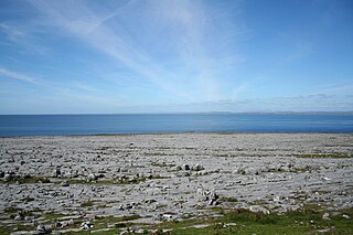
The Burren is a karst/glaciokarst landscape centred in County Clare, on the west coast of Ireland. It measures around 530 square kilometres (200 sq mi), within the circle made by the villages of Lisdoonvarna, Corofin, Gort and Kinvara. The area includes such natural features as Mullaghmore hill and Ailladie cliffs, and historic monuments such as Poulnabrone dolmen and Caherconnell Stone Fort. The Burren National Park covers a small part of the Burren and is the smallest of the six National Parks in Ireland, while the adjacent territory, including the Cliffs of Moher, is included in the Burren and Cliffs of Moher Geopark.

<span class="mw-page-title-main">Coole Park</span> Nature reserve in Ireland, former estate of Gregory family

Coole Park is a nature reserve of approximately 1,000 acres (4 km2) located a few miles west of Gort, County Galway, Ireland. It is managed by the Irish National Parks & Wildlife Service, part of the Department of Arts, Heritage and the Gaeltacht. The park is in a low–lying karstic limestone area characterised by seasonal lakes, known as turloughs, which are almost unique to Ireland. It has extensive woodlands. There are 6 kilometres of signposted nature trails plus a formal late 18th century walled garden.

<span class="mw-page-title-main">Mushroom stones</span>

Mushroom stones, or mushroom rocks, in Ireland are limestone boulders undercut by past weathering regimes. These rocks take the form of solitary sentinels of limestone which still bear the unmistakable marks of long-continued erosion by ice, soil or lapping waves at the edge of lakes which have since vanished or retreated. These stones are sometimes shaped like mushrooms, others have an overhang facing in just one direction, but all are notched and undercut in such a fashion as to suggest prolonged exposure to standing water at some time in the past. The mushroom-shaped stones are produced where the notching forms a fairly even circle around the stone.

<span class="mw-page-title-main">Kretschmarr Cave mold beetle</span> Species of beetle

The Kretschmarr Cave mold beetle is a small mold beetle.

Rahasane turlough is a turlough, west of Craughwell in southwest County Galway. It is the largest surviving turlough in Ireland.

Carmel National Nature Reserve lies close to the village of Carmel in Carmarthenshire. It lies south of Llandeilo not far from the main road to Llanelli. There is a small car park and picnic site for visitors, and footpaths for access. There is an explanatory notice board at the car park. The site is managed by the Wildlife Trust of South and West Wales and Natural Resources Wales (NRW).

<i>Tanymastix stagnalis</i> Species of small freshwater animal

Tanymastix stagnalis is a species of Anostraca that lives in temporary pools across Europe. It may reach up to 2 cm (0.8 in) in some areas and has 11 pairs of bristly, flattened appendages. It swims upside-down and filters food particles from the water. It is the only species of Anostraca in Ireland, having been discovered in Rahasane turlough in 1974.

<span class="mw-page-title-main">Flora of Ireland</span>

Ireland is in the Atlantic European Province of the Circumboreal Region, a floristic region within the Holarctic.

<span class="mw-page-title-main">Bladen Nature Reserve</span> Nature reserve in Toledo, Belize

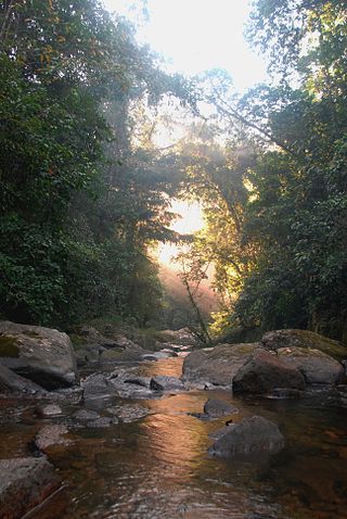
Bladen Nature Reserve in Belize is a landscape of caves, sinkholes, streams and rivers, old growth rainforest and an abundance of highly diverse flora and fauna which includes a great deal of rare and endemic species.

<span class="mw-page-title-main">Cernydd Carmel</span> Site of Special Scientific Interest in Wales

Cernydd Carmel is a Site of Special Scientific Interest in Carmarthenshire, Wales.

<span class="mw-page-title-main">Turlough Hill Power Station</span> Hydroelectric station in Wicklow, Ireland

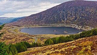
The Turlough Hill Power Station is a pumped storage power station in Ireland, owned and operated by the Electricity Supply Board (ESB).

Callows are a type of wetland found in Ireland. They are a seasonally flooded grassland ecosystem found on low-lying river floodplains.

<span class="mw-page-title-main">Lough Funshinagh</span> Ecological site in County Roscommon, Ireland

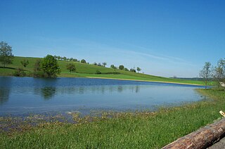
Lough Funshinagh is a lake and Special Area of Conservation in County Roscommon, Ireland, found to the west of Lough Ree. It has been called Ireland's amazing disappearing lake, due to the way it empties quickly - in as little as two days - and unpredictably, sometimes killing thousands of fish. Lough Funshinagh is one of a number of seasonal lakes, or turlough, found in the karst areas of Ireland, west of the River Shannon.

<span class="mw-page-title-main">Karst lake</span> Lakes formed as a result of the collapse of caves

Karst lakes are formed as the result of a collapse of caves, especially in water-soluble rocks such as limestone, gypsum and dolomite. This process is known as karstification. They can cover areas of several hundred square kilometres. Their shallow lakebed is usually an insoluble layer of sediment so that water is impounded, leading to the formation of lakes. Many karst lakes only exist periodically, but return regularly after heavy rainfall.

<i>Rhadine infernalis</i> Species of beetle

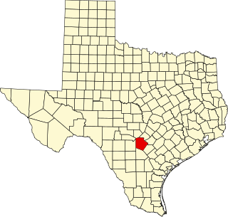
Rhadine infernalis is a species of troglobitic beetle of the family Carabidae. They are endemic to the county of Bexar, Texas. Within this county, R. infernalis has been found in 39 caves. There are 2 named subspecies of R. infernalis: R. infernalis infernalis and R. infernalis ewersi. There is a third possible subspecies that has not been officially described. R. infernalis was classified in 2000 as endangered under the IUCN Endangered Species Act of 1973, along with 8 other karst invertebrates in the same region. It has the widest known range of the endangered karst invertebrates.

<span class="mw-page-title-main">Nedern Brook Wetlands</span>

The Nedern Brook Wetland is a flood meadow habitat near Caldicot, Monmouthshire, Wales, designated since 1988 as a Site of Special Scientific Interest (SSSI). The site is of 44.5 hectares and is bridged by the M48 motorway. The spelling Neddern is used in some documents. Nedern Brook is also called Troggy Brook.

References

  1. "eDIL 2019: An Electronic Dictionary of the Irish Language, based on the Contributions to a Dictionary of the Irish Language (Dublin: Royal Irish Academy, 1913-1976)" . Retrieved 8 December 2021.
  2. 1 2 3 4 5 Reynolds, Julian D.; Duigan, Catherine; Marnell, Ferdia; O'Connor, A. (1998). Extreme and Ephemeral Water Bodies in Ireland. Chapter 4 in: Studies in Irish Limnology, Editor: P.S. Giller. The Marine Institute (Dublin, Ireland).
  3. 1 2 Blackstock, T. H.; Duigan, C. A.; Stevens, D. P.; Yeo, M. J. M. (September 1993). "Case studies and reviews. Vegetation zonation and invertebrate fauna in Pant-y-llyn, an unusual seasonal lake in South Wales, UK". Aquatic Conservation: Marine and Freshwater Ecosystems. 3 (3): 253–268. doi:10.1002/aqc.3270030309.
  4. "3180 Turloughs : Freshwater habitats". jncc.gov.uk. Joint Nature Conservation Committee . Retrieved 6 December 2021.
  5. Kelly, J. G.; Enlander, I.; Kelly, A. M.; Fogg, T. (2002). "The geological setting, hydrology and ecology of Roosky Turlough, Ely, Co. Fermanagh, Northern Ireland". Cave and Karst Science. 29 (3).
  6. "Fardrum and Roosky Turloughs". ni-environment.gov.uk. Northern Ireland Environment Agency. Archived from the original on 22 June 2010. Retrieved 17 March 2010.
  7. "Fardrum and Roosky Turloughs ASSI". ni-environment.gov.uk. Northern Ireland Environment Agency. Archived from the original on 5 August 2012. Retrieved 17 March 2010.
  8. "Site Name: Rahasane Turlough SAC" (PDF). SITE SYNOPSIS. Department of Tourism, Culture, Arts, Gaeltacht, Sport and Media. pp. 1-3 [3180] Turloughs*.
  9. "Rahasane turlough". datazone.birdlife.org. BirdLife International . Retrieved 15 June 2015.
  10. "Factsheet for Turloughs - EUNIS - European Union". European Environment Agency. Retrieved 29 December 2021.
  11. Sheehy Skeefington, Micheline; Scott, Nick E. (2008). "Do turloughs occur in Slovenia?". Acta Carsologica. 37 (2–3): 291–306. doi: 10.3986/ac.v37i2-3.153 . Retrieved 29 December 2021.
  12. 1 2 3 4 Coxon, Catherine; Reynolds, Julian. "Turloughs" (PDF). burrengeopark.ie. ENFO – The Environmental Information Service, 17 St. Andrew Street, Dublin 2. Retrieved 27 December 2021.
  13. Visser, Marjolein; Regan, Eugenie C; Moran, James; Gormally, Michael; Sheehy Skeffington, Micheline (September 2006). "The Rise and Fall of Turlough Typologies: A Call for a Continuum Concept". Wetlands. 26 (3): 745–764. doi:10.1672/0277-5212(2006)26[745:TRAFOT]2.0.CO;2. S2CID   19132700 . Retrieved 27 December 2021.
  14. Duigan, Catherine; Frey, David G. (1987). "Eurycercus glacialis in Ireland (Cladocera, Chydoridae)". Internationale Revue der gesamten Hydrobiologie und Hydrographie. 72 (2): 235–249. doi:10.1002/iroh.19870720210 . Retrieved 27 December 2021.

Further reading