Aliso Viejo is a city in the San Joaquin Hills of southern Orange County, California. It had a population of 52,176 as of the 2020 census, up from 47,823 as of the 2010 census. It became Orange County's 34th city on July 1, 2001, the only city in Orange County to be incorporated since 2000. It is bordered by the cities of Laguna Beach on the west and southwest, Laguna Hills on the east, Laguna Niguel on the southeast, and Laguna Woods on the north. It is similarly named to another nearby city, Mission Viejo.

Irvine Unified School District is a school district in Irvine, California, United States, that serves the city of Irvine. Established on June 6, 1972, IUSD serves approximately 36,000 K-12 students at twenty-four elementary schools, six middle schools, five K-8 schools, two virtual academies, six comprehensive high schools.

Area code 949 is a telephone area code in the North American Numbering Plan (NANP) for the U.S. state of California in southern Orange County. The area code was assigned on April 18, 1998, to a numbering plan area that resulted from a boundary change of area code 714 to exclude the southern cities of Orange County.
The San Diego Creek bicycle path is a cycling route in the city of Irvine, California. The path connects major points such as Newport Beach, University of California, Irvine, Boomers Irvine, Colonel Bill Barber Park, Irvine Civic Center, Irvine Crossroads shopping center, Woodbridge High School, Woodbridge Community Park, Atria Senior Residential Area, Windrow Community Park and Irvine Medical Complex, before reaching Irvine Spectrum Center. It also runs through the majority of Irvine's neighborhoods such as Westpark, Woodbridge, and Oak Creek. The path begins where the San Diego Creek empties into Upper Newport Bay.

Irvine is the largest city and a master-planned city in central Orange County, California, United States, in the Los Angeles metropolitan area. The Irvine Company started developing the area in the 1960s and the city was formally incorporated on December 28, 1971. The 66-square-mile (170 km2) city had a population of 307,670 at the 2020 census; it is the 63rd most populous city in the United States.
University Hills is a housing development on the campus of the University of California, Irvine (UCI) in southern Irvine, California, United States, consisting of 1226 for-sale homes and 384 rental units. University Hills was developed by the Irvine Campus Housing Authority, a not-for-profit corporation under the control of the university. UC Irvine developed the area as "a way to compensate for high Orange County housing costs that can keep a recruit from accepting a job at the university."

William R. Mason Regional Park, or as it is more commonly referred to, Mason Park, is a park in southern Irvine, California. It is one of the largest parks in Irvine and is traversed by trails.

Vista Verde School is a year-round, K-8 school located in the Turtle Ridge neighborhood of Irvine, California, United States. Vista Verde belongs to the Irvine Unified School District but is not a neighborhood school; rather, it is open to all Irvine residents with a preference for Turtle Ridge residents, and is one of four year-round schools in the Irvine district.
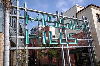
Mission Hills is a neighborhood of San Diego, California, United States. It is located on hills just south of the San Diego River valley and north of downtown San Diego and San Diego International Airport, overlooking Old Town, Downtown San Diego, and San Diego Bay.

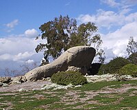
The San Joaquin Hills are a low mountain range of the Peninsular Ranges System, located in coastal Orange County, California.

Paradise Hills is an urban neighborhood in the southeastern area of the city of San Diego, California. It is an outlying neighborhood adjacent to the independent city of National City and the unincorporated communities of Lincoln Acres and certain portions of Bonita. The neighborhood is part of the Skyline-Paradise Hills Community Planning Area.
Buffalo Ranch was a tourist attraction which was operated on 115 acres (0.47 km2) in what is today Newport Beach, California by Gene Clark of the Irvine Company and the grandson of the famous Indian chief Geronimo. It was the first outside business to be allowed onto land owned by The Irvine Company. The ranch began with a herd of 72 buffalo, and this number quickly grew. Several Indian families from Kansas were invited to live in the area and work at the Ranch to add to its authenticity and present various tribal dances for the tourists. Bison Road, which exists today as a connection between Jamboree and MacArthur roads in Newport Beach, was originally created as an access road to Buffalo Ranch.

Clairemont is a community within the city of San Diego, California, United States. It has a population of about 81,600 residents and an area of roughly 13.3 square miles (34 km2). Clairemont Mesa is bordered by Interstate 805 on the east, Interstate 5 to the west, State Route 52 to the north, and the community of Linda Vista to the south. The community of Clairemont Mesa can be subdivided into the neighborhoods of North Clairemont, Clairemont Mesa East, Clairemont Mesa West, Bay Park, and Bay Ho.

El Cerrito is a neighborhood of the Mid-City region of San Diego, California. El Cerrito is a residential neighborhood, consisting mostly of suburban homes, with some commercial activity along the streets that define its borders.
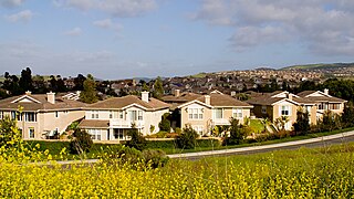
Anaheim Hills is an affluent, planned community encompassing the eastern portions of the city of Anaheim, in Orange County, California.

Northwood is a community encompassing the northern portions of the city of Irvine, in Orange County, California. It covers the area enclosed by the Santa Ana Freeway, Culver Drive, Portola Parkway and Jeffrey Road.
Rancho Santiago de Santa Ana was a 63,414-acre (256.63 km2) Spanish land concession in present-day Orange County, California, given by Spanish Alta California Governor José Joaquín de Arrillaga in 1810 to Jose Antonio Yorba and his nephew Pablo Peralta. The grant extended eastward from the Santa Ana River to the Santa Ana Mountains, with a length of more than 22 miles (35 km).

Peters Canyon Regional Park is a regional park within the Orange County Regional Parks System in California. The park contains 354 acres of southern California wildlife, including coastal sage shrub, riparian, freshwater marsh, and grasslands, and is located within the boundaries of both Orange, California and Tustin, California. Peters Canyon was given to this city in 1992 by the Irvine Company who had used it previously for cattle grazing. The canyon is lined with a residential area on one side and open hills on the other. This canyon is commonly used by hikers, mountain bikers, and equestrians because of the trails that circumvent the 50 acre man-made lake, which was constructed by the Irvine Company in 1931, on the interior of the plot. The regional park is open from 7:00 AM to sunset every day of the week, save for the chance of rain or hazardous conditions, in which case the park will be closed for three days following the particular occurrence.
University Park is a master-planned neighborhood in Irvine, California. It is bounded by University Drive to the south, Culver Drive to the west, and the San Diego (I-405) Freeway to the north. Commercially advertised as Irvine's first "village", the neighborhood was named University Park due to its proximity to the University of California, Irvine. University Park celebrated its 50th anniversary in July 2016.
Culver Drive is a major arterial road in Irvine, Orange County, California, running approximately 9 miles (14 km) from southwest to northeast. Its southwest end is at its junction with Anteater Drive and Shady Canyon Drive, at the meeting point of the Turtle Rock, Turtle Ridge, and University Hills neighborhoods of Irvine. However, the road continues to the southwest under different names, Bonita Canyon Drive and then Ford Road, through a junction with California State Route 73 and into Newport Beach. At its northwest end, Culver Drive ends at its junction with Furrow in the Orchard Hills neighborhood of Irvine. Its length is split roughly into thirds by its junctions with Interstate 405 towards its southwest end and with Interstate 5 towards its northeast end. For much of its length, it parallels California State Route 261, which runs to its northwest.