San Joaquin Hills

Last updated
San Joaquin Hills
CA73.jpg
State Route 73 climbs into the San Joaquin Hills, as seen looking southward from University Hills, Irvine
Highest point
PeakTemple Hill (California)
Elevation 1,050 ft (320 m)
Geography
Relief map of California.png
Red triangle with thick white border.svg
location of San Joaquin Hills in California [1]
CountryUnited States
State California
Region Peninsular Ranges
District Orange County
Range coordinates 33°36′42.081″N117°48′33.198″W / 33.61168917°N 117.80922167°W / 33.61168917; -117.80922167 Coordinates: 33°36′42.081″N117°48′33.198″W / 33.61168917°N 117.80922167°W / 33.61168917; -117.80922167
Borders on Santa Ana Mountains
Topo map USGS  Laguna Beach

The San Joaquin Hills are a low mountain range of the Peninsular Ranges System, located in coastal Orange County, California. [1]

Contents

They extend in a northwest–southeast direction, starting in the northwest in Newport Beach at the southern edge of the Los Angeles Basin, and extending southeast to San Juan Capistrano.

Geography and habitats

Named summits in the San Joaquin Hills include (from north to south) French Hill in Turtle Rock, Irvine; Signal Peak and Pelican Hill, both of which are near the Newport Coast neighborhood of Newport Beach; Temple Hill in Laguna Beach, more commonly known as "Top of the World" after the neighborhood on its peak; and Niguel Hill in Laguna Niguel. [2]

Geology

A fault line, the San Joaquin Hills blind thrust, lies eight miles below the hills. [3] Scientists have suggested that the San Joaquin Hills have been formed by uplift from this fault. [4]

The main ridge of the San Joaquin Hills runs southeast from the Upper Newport Bay area, attaining its maximum height of roughly 1,000 feet (300 m) near Laguna Beach. Many of the high ridges exceed 600 to 800 feet (180 to 240 m) in height. The hills stretch over a distance of about 16 miles (26 km) and can be up to 3 to 4 miles (4.8 to 6.4 km) broad. In many places, the San Joaquin Hills drop directly into the Pacific Ocean, creating the steep sea cliffs that characterize the region. Streams that originate on the west slope of the range include Buck Gully, Los Trancos Creek, Muddy Creek, El Moro Creek, Emerald Creek, Prima Deshecha Cañada, Segunda Deshecha Cañada, and Christianitos Canyon. The east side is drained by Bonita Creek, Sand Canyon Wash, San Joaquin Wash, and La Cañada Wash. Cities bordering the range include Newport Beach, Irvine, Laguna Hills, Aliso Viejo, Laguna Beach, Laguna Niguel, Dana Point, San Juan Capistrano, and San Clemente.

Because of erosion phenomena during the previous Ice Age, the San Joaquin Hills are not one continuous mountain range, but instead are bisected by numerous water gaps cut by rivers flowing southwest from the Santa Ana Mountains. In the north, Newport Bay was formed by the Santa Ana River switching its course to the south, cutting across the northern part of the range. Laguna Canyon was formed by San Diego Creek, but eventually the larger creek changed course and left a wind gap through the hills. The largest canyon by far is Aliso Canyon, cut by Aliso Creek. Further south, the hills dissipate into smaller ridges and are bisected by the canyon of Salt Creek. The southern extent of the hills are cut by San Juan Creek.

Flora and fauna

The native vegetation of the hills is in the California coastal sage and chaparral and California chaparral and woodlands ecoregions, largely coastal sage scrub, but other habitat types include grasslands, oak woodlands, wetlands, and riparian habitats along several streams. [5]

In past ages the land that is now the San Joaquin Hills lay under the ocean: construction for the San Joaquin Hills Toll Road unearthed a number of artifacts and more than 40,000 fossils, up to 35 million years old, including 5-million-year-old fossilized whales. [6]

History

Prior to the arrival of Europeans in the area, residents of the nearby Tongva and Acjachemen village of Genga frequented the hills. [7]

The hills take their name from Rancho San Joaquin, owned by Jose Andres Sepulveda. Formed in 1842 by the merger of two smaller ranches, this ranch included the northern part of the hills and likely had Laguna Canyon as its southeastern boundary. Rancho San Joaquin later became part of the Irvine Ranch. [8] Mexican Rancho Niguel was located in the southeastern section of the hills.

The San Joaquin Hills blind thrust may be the source of the earliest recorded earthquake in California, a large earthquake felt in what is now northern Orange County on July 28, 1769, by Gaspar de Portolá. [9]

Development

Two neighborhoods within the San Joaquin Hills take the name of the hills for their own: San Joaquin Hills, Newport Beach, California, a former census-designated place annexed to the city of Newport Beach, and San Joaquin Hills, Laguna Niguel, California, a master-planned community located in the city of Laguna Niguel. Other neighborhoods set in and named after hills in this range include University Hills and Turtle Rock in Irvine.

State Route 73, also called the San Joaquin Hills Toll Road, extends through the length of the hills from Newport Beach to San Juan Capistrano. State Route 133 crosses the hills through Laguna Canyon in Laguna Beach, and they are also crossed in several other places by less major roads.

See also

Related Research Articles

<span class="mw-page-title-main">Aliso Viejo, California</span> City in the state of California, United States

Aliso Viejo is a city in the San Joaquin Hills of southern Orange County, California. It had a population of 47,823 as of the 2010 census, up from 40,166 as of the 2000 census. It became Orange County's 34th city on July 1, 2001, the only city in Orange County to be incorporated since 2000. It is bordered by the cities of Laguna Beach on the west and southwest, Laguna Hills on the east, Laguna Niguel on the southeast, and Laguna Woods on the north.

<span class="mw-page-title-main">Laguna Niguel, California</span> City in the state of California, United States

Laguna Niguel is a city in Orange County, California, United States. The name Laguna Niguel is derived from the words "Laguna" and "Niguili". As of the 2020 census, the population was 64,355. Laguna Niguel is located in the San Joaquin Hills in the southeastern corner of Orange County, close to the Pacific Ocean, and borders the cities of Aliso Viejo, Dana Point, Laguna Beach, Laguna Hills, Mission Viejo, and San Juan Capistrano.

<span class="mw-page-title-main">California State Route 73</span> Highway and toll road in Orange County, California

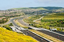
State Route 73 (SR 73) is an approximately 17.76-mile (28.58 km) state highway in Orange County, California. The southernmost 12 miles (19.31 km) of the highway is a toll road operated by the San Joaquin Hills Transportation Corridor Agency named the San Joaquin Hills Transportation Corridor, which opened in November 1996. The northernmost 5.76 miles (9.27 km) of the highway, which opened in 1978, is part of the Corona del Mar Freeway. SR 73's southern terminus is at Interstate 5 (I-5) in San Juan Capistrano and its northern terminus is at Interstate 405 (I-405) in Costa Mesa. The highway's alignment through the San Joaquin Hills follows an approximately parallel path between the Pacific Coast Highway and I-405. Currently, there are no HOV lanes for the three-mile freeway segment, but the medians have been designed with sufficient clearance for their construction should the need arise in the future.

<span class="mw-page-title-main">Area code 949</span> Telephone area code for southern Orange County, California

Area code 949 is an area code in the U.S. state of California that is contained within southern Orange County, California. On April 18, 1998, the southern cities of Orange County were split from 714, creating area code 949. It includes cities such as Newport Beach, Irvine, Lake Forest, Portola Hills, Coto de Caza, Dove Canyon, Aliso Viejo, Trabuco Canyon, Capistrano Beach, Corona del Mar, Laguna Niguel, Laguna Hills, Laguna Woods, Newport Coast, Foothill Ranch, Robinson Ranch, Mission Viejo, San Juan Capistrano, Rancho Santa Margarita, Ladera Ranch, Dana Point, Laguna Beach, and San Clemente. The city of Costa Mesa is shared between the 949 and 714 area codes, being split at Wilson Street and along Newport Boulevard. A very small portion of Irvine is also in the 714 area code, from the north side of Culver Drive at the I-5 to Jamboree Road in the Marketplace, in the neighborhood of Northpark Irvine.

<span class="mw-page-title-main">San Juan Creek</span> River in Orange County, California, United States

San Juan Creek, also called the San Juan River, is a 29-mile (47 km) long stream in Orange and Riverside Counties, draining a watershed of 133.9 square miles (347 km2). Its mainstem begins in the southern Santa Ana Mountains in the Cleveland National Forest. It winds west and south through San Juan Canyon, and is joined by Arroyo Trabuco as it passes through San Juan Capistrano. It flows into the Pacific Ocean at Doheny State Beach. San Juan Canyon provides a major part of the route for California State Route 74.

<span class="mw-page-title-main">Aliso Creek (Orange County)</span> River in the United States of America

Aliso Creek is a 19.8-mile (31.9 km)-long, mostly urban stream in south Orange County, California. Originating in the Cleveland National Forest in the Santa Ana Mountains, it flows generally southwest and empties into the Pacific Ocean at Laguna Beach. The creek's watershed drains 34.9 square miles (90 km2), and it is joined by seven main tributaries. As of 2018, the watershed had a population of 144,000 divided among seven incorporated cities.

<span class="mw-page-title-main">Oso Creek</span> Tributary of Arroyo Trabuco in Orange County, California

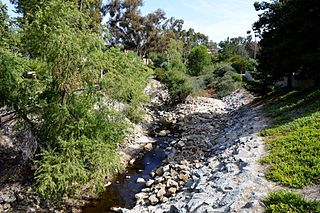
Oso Creek is an approximately 13.5-mile (21.7 km) tributary of Arroyo Trabuco in southern Orange County in the U.S. state of California. Draining about 20 square miles (52 km2) in a region north of the San Joaquin Hills and south of the Santa Ana Mountains, the creek is Trabuco Creek's largest tributary, and is part of the San Juan Creek drainage basin. Beginning in the foothills of the Santa Ana Mountains near the city of Mission Viejo, the creek is dammed twice to form Upper Oso Reservoir and Lake Mission Viejo. The creek is channelized and polluted along much of its length.

<span class="mw-page-title-main">Aliso and Wood Canyons Wilderness Park</span>

Aliso and Wood Canyons Wilderness Park is a major regional park in the San Joaquin Hills of Orange County, California in the United States. Comprising 4,500 acres (1,800 ha) of rugged coastal canyons, open grassland, and riparian woodland, the park borders the suburban cities of Aliso Viejo, Dana Point, Laguna Beach, Laguna Hills and Laguna Niguel and lies within a portion of the ancestral homeland of the indigenous Acjachemen people.

<span class="mw-page-title-main">Salt Creek (Orange County)</span> River in California, United States

Salt Creek is a small coastal stream in southern Orange County in the U.S. state of California. The 4-mile (6.4 km) creek drains 6.1 square miles (16 km2) in parts of the cities of Laguna Niguel, Dana Point, and San Juan Capistrano. The mostly channelized creek has no named surface tributaries. The creek begins in the central portion of the city of Laguna Niguel and flows west and south through a narrow canyon referred to as the Salt Creek Corridor, which is mostly inside a long and narrow regional park. It then flows into the Monarch Beach Golf Course in the city of Dana Point and enters a subsurface storm channel which carries it to its discharge point at Salt Creek County Beach.

<span class="mw-page-title-main">Laguna Canyon</span> Canyon in Tongva Territory, United States of America

Laguna Canyon is a canyon that cuts through the San Joaquin Hills in southern Orange County, California, in the United States, directly south of the city of Irvine. The canyon runs from northeast to southwest, and is drained on the north side by tributaries of San Diego Creek and on the south by Laguna Canyon Creek. It is deeper and more rugged on the southwestern end near Laguna Beach.

<span class="mw-page-title-main">San Diego Creek</span> River in California, United States

San Diego Creek is a 16-mile (26 km) urban waterway flowing into Upper Newport Bay in Orange County, California in the United States. Its watershed covers 112.2 square miles (291 km2) in parts of eight cities, including Irvine, Tustin, and Costa Mesa. From its headwaters in Laguna Woods the creek flows northwest to its confluence with Peters Canyon Wash, where it turns abruptly southwest towards the bay. Most of the creek has been converted to a concrete flood control channel, but it also provides important aquatic and riparian habitat along its course and its tidal estuary.

<span class="mw-page-title-main">Sulphur Creek (California)</span> Creek in California, United States

Sulphur Creek is a 4.5-mile (7.2 km) tributary of Aliso Creek in Orange County in the U.S. state of California. The creek drains about 6 square miles (16 km2) of residential communities and parks in the southern San Joaquin Hills.

<span class="mw-page-title-main">Aliso Canyon</span> Canyon located in Laguna Beach California

Aliso Canyon is a 6.5-mile (10.5 km) canyon located in Orange County, California in the United States. The canyon is a water gap across the San Joaquin Hills carved out by Aliso Creek, possibly as recently as the last ice age. Located in a semi-arid climate, it supports a variety of plant communities – mainly chaparral and coastal sage scrub – and native animals, some endangered.

Sand Canyon Wash is an approximately 6.9-mile (11.1 km) tributary of San Diego Creek in Orange County, southern California.

<span class="mw-page-title-main">Laguna Coast Wilderness Park</span>

Laguna Coast Wilderness Park is a 7,000-acre (2,800 ha) wilderness area in the San Joaquin Hills surrounding Laguna Beach, California. This park features coastal canyons, ridgeline views and the only natural lakes in Orange County, California. Trails are maintained for hiking and mountain biking with a wide range of difficulty, from beginner to expert. Most trails gain in height, reaching a maximum of 1,000 feet (300 m) in elevation. Several trails lead to downtown Laguna Beach.

Rancho Niguel was a 13,316-acre (53.89 km2) Mexican land grant in the San Joaquin Hills, within present-day Orange County, California.

Will O'Neill is the former Mayor of the City of Newport Beach and Chair of the San Joaquin Hills Transportation Corridor Agency.

Orange County Parks, more commonly abbreviated to OC Parks, is a government agency that maintains and oversees the public parks of Orange County, California. The agency operates both natural and manmade parks of the region. OC Parks is responsible for 60,000 acres (24,000 ha) of inland and coastal open space that collectively receives millions of visitors every year.

References

  1. 1 2 "San Joaquin Hills". Geographic Names Information System . United States Geological Survey, United States Department of the Interior . Retrieved 2009-05-04.
  2. U.S. Geological Survey Geographic Names Information System: French Hill, elevation 397 ft. / 121 m. U.S. Geological Survey Geographic Names Information System: Signal Peak, elevation 1161 ft. / 354 m. U.S. Geological Survey Geographic Names Information System: Pelican Hill, elevation 725 ft. / 221 m. U.S. Geological Survey Geographic Names Information System: Temple Hill, elevation 1007 ft. / 307 m. U.S. Geological Survey Geographic Names Information System: Niguel Hill, elevation 935 ft. / 285 m. (prior to grading for real estate development).
  3. Robbins, Gary (March 11, 1999), Fault found beneath San Joaquin Hills: The 23-mile-long system is similar to the one that produced the Northridge shaker, Orange County Register ; Robbins, Gary (November 1, 2001), Scientists to evaluate seismic threat in San Joaquin Hills, Orange County Register ; Orange County's Hills Hold Key To Earthquake Findings, KNBC, April 15, 2004; County at risk for Northridge-size quakes say UCI researchers, Orange County Register, April 22, 2004.
  4. Grant, Lisa B.; Mueller, Karl J.; Gath, Eldon M.; Cheng, Hai; Edwards, R. Lawrence; Munro, Rosalind; Kennedy, George L. (1999), "Late Quaternary uplift and earthquake potential of the San Joaquin Hills, southern Los Angeles Basin, California", Geology, 27 (11): 1031–1034, doi:10.1130/0091-7613(1999)027<1031:LQUAEP>2.3.CO;2 .
  5. Aliso and Wood Canyons Wilderness Park Archived 2006-11-10 at the Wayback Machine open house booklet, Orange County Park System, 2006.
  6. Roan, Shari (November 19, 1989), San Joaquin tollway work breaks historical ground, Orange County Register ; Downey, Cheryl (April 28, 1993), Fine whale skeletons unearthed: Paleontologists discover nearly intact skeletons along route of San Joaquin Hills toll road, Orange County Register ; Downey, Cheryl (May 11, 1993), A window to our past: Scientists who are checking the San Joaquin Hills tollway route remove and preserve fossils millions of years old before construction starts, Orange County Register ; Brennan, Pat (June 18, 1993), Fossil whale makes a delicate journey to county museum: Five million-year-old `Bones' is carefully loaded onto a truck for its trip to Buena Park, Orange County Register ; Brennan, Pat (April 4, 1998), Highway to history: Bones reveal a scenic road through the county's past, Orange County Register ; Chang, Daniel (May 1, 1999), Dig this!, Orange County Register ; Peralta, Jessica (May 17, 2002), Bones about it: Toll road construction unearths fossil treasure trove for school lectures, Orange County Register .
  7. Koerper, Henry; Mason, Roger; Peterson, Mark (2002). Catalysts to complexity : late Holocene societies of the California coast. Jon Erlandson, Terry L. Jones, Jeanne E. Arnold, Cotsen Institute of Archaeology at UCLA. Los Angeles: Cotsen Institute of Archaeology at UCLA. p. 64. ISBN   978-1-938770-67-8. OCLC   745176510.
  8. Goetz, Peggy (June 13, 2002), History buff likes telling the story of Jose Sepulveda, Irvine World News[ permanent dead link ].
  9. Grant, Lisa B.; Ballenger, Leslie J.; Runnerstrom, Eric E. (2002), "Coastal Uplift of the San Joaquin Hills, Southern Los Angeles Basin, California, by a Large Earthquake since A.D. 1635", Bulletin of the Seismological Society of America, 92 (2): 590–599, doi:10.1785/0120010119 ; Coledan, Stefano (April 2002), "California Earthquake Described By 18th Century Spanish Explorer", Popular Mechanics , archived from the original on 2008-08-29. Listed by the United States Geological Survey as the earliest recorded earthquake in California on their Earthquake Facts Archived 2009-02-26 at the Wayback Machine web page.