Genga, California

Last updated
Fairview Park in Costa Mesa (2017) adjacent to Banning Ranch. Newport Beach Fairview Park 2017.jpg
Fairview Park in Costa Mesa (2017) adjacent to Banning Ranch.

Genga, alternative spelling Gengaa and Kengaa, [1] [2] was a Tongva and Acjachemen village located on Newport Mesa overlooking the Santa Ana River in the Newport Beach and Costa Mesa, California area which included an open site now referred to as Banning Ranch. [3] [4] [5] Archaeological evidence dates the village at over 9,000 years old. [6] [7] Villagers were recorded as Gebit in Spanish Mission records. [8] The village may have been occupied as late as 1829 or 1830. [1]

Contents

An attempt in 2001 to preserve a nearby 9,000 year old village site from commercial development failed. A similar attempt to save a burial site of Genga in the 2010s also failed. [7] [6] This has initiated concerns over preservation in the area. A large part of the contemporary site of Genga situated in Banning Ranch may be transformed into a public open space as of 2022. The Tongva and Acjachemen support having a voice in the process. [3]

History

Indigenous

Genga was in close proximity and had influence over Newport Bay, as reflected in the bay's original name given by the Spanish Bolsa de Gengar. The village's influence may have extended up to the northern San Jaoquin Hills. [9] One estimate placed the village population at around 100–150 at the time of contact. The village was multiethnic and multilingual, being shared by the Tongva and Acjachemen. [9]

Archaeological evidence dates the village to be at least 9,000 years old. [6] As a coastal village, the usage of te'aats may have been important to the village's people. [10] [11] It is also likely that, similar to the nearby village of Lupukngna, villagers primarily subsisted on acorns, seeds, berries, small game, fish and shellfish. Shell mounds were a part of village life. [12] [13] Cog stones have been found in the village area as well. [6]

Spanish mission period

The Diego Sepulveda Adobe was built in 1817 as a Mission outpost to surveil the villagers. Diego Sepulveda Adobe Historical Monument ^227 - panoramio (2).jpg
The Diego Sepúlveda Adobe was built in 1817 as a Mission outpost to surveil the villagers.

After the arrival of the Spanish colonizers, villagers were baptized at San Gabriel and San Juan Capistrano missions and had marriage ties with villagers from Hutuknga, Puvunga, and settlements around San Juan Capistrano. [9] The Diego Sepúlveda Adobe was built overlooking Lupukngna and Genga from between 1817 and 1823 [15] [14] as an outpost "to watch over cattle and Indians." In 1827, missionaries considered whether to move their entire operation to the location. [16]

Like many surrounding Tongva and Acjachemen villages, the village declined with the growth of the missions, where Indigenous labor was exploited to construct mission facilities and tend to the mission's grounds. By the early nineteenth century, the village was being depleted and may have been occupied until 1829 or 1830. [17] Yet, the place name carried forward in the nineteenth century, with the bay being labeled the bolsa de gengara, an alternative spelling of the village, on an 1853 map. [17]

Preservation attempts

Human remains from the village were uncovered in the 2010s. Although Tongva and Acjachemen people campaigned to stop the development of a site where six hundred of their ancestors' remains were found, their attempt failed. [18] The remains were moved from the original burial site, which now sits under a parking lot next to a bank, to a dirt lot about a half-mile away. [7] Lack of federal recognition of the Tongva and Acjachemen prevents them from controlling their ancestral remains and artifacts. [19] [20]

In 2013, the city of Costa Mesa may have approved plans to construct over a site near the village location in nearby Fairview Park, despite archaeologists and Indigenous people speaking against further development in the area given the significance of the site, as well as its listing on the National Register of Historic Places since 1972. [21] There were further concerns that the archaeological survey was being conducted by the Scientific Resource Surveys, Inc. (SRS), which has a poor track record in the area for preserving Tongva village sites, being fined $600,000 for digging trenches into a 9,000 year old village site in Bolsa Chica in 2001. [6]

Banning Ranch, part of the site of Genga, which had been a large coastal oil field since 1943, may be transformed into a public open space as of 2022 after many years of organizing to preserve the site both as green space for the city as well as for historic preservation. [3] [22] City leaders of the project have said that "tribal descendants of the area’s earliest residents will also have a voice" in how the park is developed. [23]

See also

Achachemen villages in Orange County, California

Tongva villages in Orange County, California

Related Research Articles

<span class="mw-page-title-main">Orange County, California</span> County in California, United States

Orange County is a county located in the Los Angeles metropolitan area in Southern California, United States. As of the 2020 census, the population was 3,186,989, making it the third-most-populous county in California, the sixth-most-populous in the United States, and more populous than 19 American states and Washington, D.C. Although largely suburban, it is the second-most-densely-populated county in the state behind San Francisco County. The county's three most-populous cities are Anaheim, Santa Ana, and Irvine, each of which has a population exceeding 300,000. Santa Ana is also the county seat. Six cities in Orange County are on the Pacific coast: Seal Beach, Huntington Beach, Newport Beach, Laguna Beach, Dana Point, and San Clemente.

<span class="mw-page-title-main">Costa Mesa, California</span> City in Orange County, California, United States

Costa Mesa is a city in Orange County, California, United States. Since its incorporation in 1953, the city has grown from a semi-rural farming community of 16,840 to an urban area including part of the South Coast Plaza–John Wayne Airport edge city, one of the region's largest commercial clusters, with an economy based on retail, commerce, and light manufacturing. The city is home to the two tallest skyscrapers in Orange County. The population was 111,918 at the 2020 census.

Putuidem, alternative spelling Putiidhem or Putuidhem, was a large native village of the Acjachemen people, also known as Juaneño since their relocation to Mission San Juan Capistrano. Putuidem was a mother village, a community that spawned other villages of the tribe.

<span class="mw-page-title-main">Newport Back Bay</span>

The Back Bay is the colloquial term for the inland delta in Newport Beach, California. It connects the Upper Newport Bay with the Newport Harbor. It is a nature reserve home to several species of birds with hiking and biking trails. The bay is recognized for protection by the California Bays and Estuaries Policy.

<span class="mw-page-title-main">Puvunga</span> Indigenous sacred site in Long Beach, California, US

Puvunga is an ancient village and sacred site of the Tongva nation, the Indigenous people of the Los Angeles Basin, and the Acjachemen, the Indigenous people of Orange County. The site is now located within California State University, Long Beach and the surrounding area. The Tongva know Puvunga as the "place of emergence" and it is where they believed "their world and their lives began". Puvunga is an important ceremonial site and is the end to an annual pilgrimage for the Tongva, Acjachemen, and Chumash.

Olive is an unincorporated parcel of about 32.67 acres (132,200 m2) entirely surrounded by the city of Orange, located along Lincoln Avenue, between Eisenhower Park and Orange Olive Road.

<span class="mw-page-title-main">San Joaquin Hills</span> Range of hills in Orange County, California, United States

The San Joaquin Hills are a low mountain range of the Peninsular Ranges System, located in coastal Orange County, California.

<span class="mw-page-title-main">Bolsa Chica Ecological Reserve</span> Natural public land in Orange County, California, US

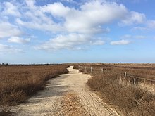
Bolsa Chica State Ecological Reserve is a natural reserve and public land in Orange County, governed by the state of California, and immediately adjacent to the city of Huntington Beach, California. The reserve is designated by the California Department of Fish and Wildlife (CDFW) to protect a coastal wetland and upland, with both migratory and resident threatened and endangered species of wildlife and wildflowers.

<span class="mw-page-title-main">Newport Bay (California)</span> Bay in southern California, USA

Newport Bay, in Southern California, United States, is the lower bay formed along the coast below the Upper Newport Bay, after the end of the Pleistocene. It was formed by sand, brought by ocean currents from the Santa Ana River and other rivers to the north, which constructed an offshore beach, now called the Balboa Peninsula. The bay was named by the Spanish Bolsa de Gengar in the 18th century, to refer to the nearby Tongva and Acjachemen village of Genga. An estuary of the Santa Ana River in the late 19th century, it was dredged to form Newport Harbor, the harbor of Newport Beach.

<span class="mw-page-title-main">Newland House</span> Historic house in California, United States

Newland House is an 1898 farmhouse in a midwestern adaptation of a Queen Anne architectural style in Huntington Beach, California, listed on the National Register of Historic Places. It is one of 123 historic places and districts on the National Register of Historic Places in Orange County, California. The Newland House is listed as the ninth historic place to receive a historical plaque from the Orange County Historical Commission in cooperation with the Orange County Board of Supervisors. The house has been identified as the site of the Tongva village of Lupukngna.

<span class="mw-page-title-main">Puhú</span> Historical native American village in California, US

Puhú was a major residential village in the Santa Ana Mountains shared by the Tongva, Acjachemen, Payómkawichum, and Serrano near Santiago Peak. The village resided approximately 600m above sea level in the upper areas of the Black Star Canyon. The village was at its height from the years 1220–1770. The village retained its multi-seasonal occupancy and economic and political systems up until its destruction and a communal massacre in 1832.

<span class="mw-page-title-main">Hutuknga</span> Former Tongva village in Yorba Linda, California

Hutuknga was a large Tongva village located in the foothills along the present channel of the Santa Ana River in what is now Yorba Linda, California. People from the village were recorded in mission records as Jutucabit. Hutuknga was part of a series of villages along the Santa Ana River, which included Lupukngna, Genga, Pajbenga, and Totpavit. The Turnball Canyon area is sometimes falsely associated with Hutuknga.

Pajbenga, alternative spelling Pagbigna and Pasbengna, was a Tongva village located at Santa Ana, California, near the El Refugio Adobe, which was the home of José Sepulveda. It was one of the main villages along the Santa Ana River, including Lupukngna, Genga, Totpavit, and Hutuknga. People from the village were recorded in mission records as Pajebet,Pajbet, Pajbebet, and Pajbepet.

Totpavit, alternative spellings Totabit and possibly Totavet, was a Tongva village located in what is now Olive, California. The village was located between the Santa Ana River and Santiago Creek. It was part of a series of villages along the Santa Ana River, including Genga, Pajbenga, and Hutuknga.

<span class="mw-page-title-main">Moyongna</span> Former Tongva village or landmark site in Newport Beach, California

Moyongna, alternatively spelled Moyonga, was a coastal Tongva village or landmark site located near the entrance of Newport Bay in Newport Beach, California near Corona del Mar. As a coastal village, the usage of te'aats was likely important to the village's people. Nearby coastal villages included Genga, located on Newport Mesa, and Lupukngna, located near the mouth of the Santa Ana River.

<span class="mw-page-title-main">Alume</span> Former Acjachemen village in California

Alume was a large Acjachemen village located at the foot of Santiago Peak, upstream from the village of Putiidhem ,within what is now O'Neill Regional Park near the Trabuco Adobe, which was built in 1810 as an outpost of Mission San Juan Capistrano. The village was also recorded as Alaugna and as El Trabuco in San Juan Capistrano mission records, and is also referred to as Alauna, Aluna, and Alona. The village was also acknowledged by the Payómkawichum.

<span class="mw-page-title-main">Lupukngna</span> Former Tongva village in Huntington Beach, California

Lupukngna was a coastal Tongva village that was at least 3,000 years old located on the bluffs along the Santa Ana River in Huntington Beach near the Newland House Museum. Other nearby coastal villages included Genga, located in West Newport Beach, and Moyongna, located down the coast near Corona del Mar. The village has also been referred to as Lukup and Lukupa. The village has been chronicled in the history of Costa Mesa, California.

<span class="mw-page-title-main">Piwiva</span> Former Acjachemen village in Rancho Mission Viejo, California

Piwiva was a Acjachemen village located at the confluence of San Juan Creek and Cañada Gobernadora tributary in what is now Rancho Mission Viejo, California. The name for the village was closely related to the Payómkawichum word for wild tobacco piivat. It was located north of Mission San Juan Capistrano, downstream from the village of Huumai and upstream from the village of Sajavit. Alternative names for the village include Pii'iv, Pivits, and Peviva.

<span class="mw-page-title-main">Acjacheme</span> Former Acjachemen village at Mission San Juan Capistrano

Acjacheme was an Acjachemen village that was closely situated to the mother village of Putuidem in what is now San Juan Capistrano, California. The Spanish missionaries constructed Mission San Juan Capistrano less than 60 yards from the village in 1776. Acjachemen is a pluralization of the word Acjacheme, and became the moniker for the people overall after the mission period.

<span class="mw-page-title-main">Tovaangar</span> Homelands of the Tongva

Tovaangar refers to the Tongva world or homelands. It includes the greater area of the Los Angeles Basin, including the San Gabriel Valley, San Fernando Valley, northern Orange County, parts of San Bernardino County and Riverside County, and the southern Channel Islands, including San Nicholas, Santa Catalina, Santa Barbara, and San Clemente. The homelands of the Chumash are to the northwest, the Tataviam to the north, the Serrano and Cahuilla to the east, and the Acjachemen and Payómkawichum to the south.

References

  1. 1 2 "Southern California Indian Curriculum Guide" (PDF). The Bowers Museum of Cultural Art. 2002.
  2. Hernandez, Kelly Lytle (2017). City of inmates : conquest, rebellion, and the rise of human caging in Los Angeles, 1771-1965. Chapel Hill. p. 18. ISBN   978-1-4696-3119-6. OCLC   974947592.{{cite book}}: CS1 maint: location missing publisher (link)
  3. 1 2 3 Hicks, Angelina (2022-06-14). "Banning Ranch is One Step Closer to Becoming Preserved Open Space". Voice of OC. Retrieved 2022-12-06.
  4. "Randall Preserve - Our Work in CA". Trust for Public Land. Retrieved 2022-12-14.
  5. Greene, Sean; Curwen, Thomas (9 May 2019). "Mapping the Tongva villages of L.A.'s past". www.latimes.com. Retrieved 2022-12-07.
  6. 1 2 3 4 5 "Survey of park to determine burial-ground limits". Orange County Register. 2013-10-09. Retrieved 2022-12-21.
  7. 1 2 3 Loewe, Ronald (2016). Of sacred lands and strip malls : the battle for Puvungna. Lanham, MD. p. 138. ISBN   978-0-7591-2162-1. OCLC   950751182.{{cite book}}: CS1 maint: location missing publisher (link)
  8. Martínez, Roberta H. (2009). Latinos in Pasadena. Charleston, SC: Arcadia. p. 10. ISBN   978-0-7385-6955-0. OCLC   402526696.
  9. 1 2 3 Koerper, Henry; Mason, Roger; Peterson, Mark (2002). Catalysts to complexity : late Holocene societies of the California coast. Jon Erlandson, Terry L. Jones, Jeanne E. Arnold, Cotsen Institute of Archaeology at UCLA. Los Angeles: Cotsen Institute of Archaeology at UCLA. p. 64. ISBN   978-1-938770-67-8. OCLC   745176510.
  10. L. Frank (2007). First families : a photographic history of California Indians. Kim Hogeland. Berkeley, Calif.: Heyday Books. p. 108. ISBN   978-1-59714-013-3. OCLC   76901815.
  11. Allan Sekula; Jack (John Kuo Wei) Tchen (2004). "Interview with Allan Sekula: Los Angeles, California, October 26, 2002". International Labor and Working-Class History (66): 162. ISSN   0147-5479. JSTOR   27672963.
  12. Early Costa Mesa. Costa Mesa Historical Society. Charleston, SC: Arcadia Pub. 2009. p. 7. ISBN   978-0-7385-6976-5. OCLC   276818569.{{cite book}}: CS1 maint: others (link)
  13. California Coastal Commission (1987). California coastal resource guide. Madge Caughman, Joanne S. Ginsberg (1st ed.). Berkeley: University of California Press. p. 320. ISBN   0-520-06186-1. OCLC   16005763.
  14. 1 2 "Indian Villages". OC Historyland. Retrieved 2022-12-14.
  15. Orton; Marsh (1997). The Colorful Coast: An Illustrated History of Newport Beach & Harbor. Heritage Media Corporation. p. 27.
  16. Mitchell, Patrick (2006). Santa Ana River Guide. Larry B. Van Dyke, Eva Dienel (1st ed.). Birmingham, Alabama. p. 219. ISBN   978-0-89997-616-7. OCLC   909903029.{{cite book}}: CS1 maint: location missing publisher (link)
  17. 1 2 "Southern California Indian Curriculum Guide" (PDF). The Bowers Museum of Cultural Art: 18. 2002.
  18. Welsh, Terry (2015-12-16). "Welsh: Coastal Commission Banning Ranch Hearings in January Need to Hear from OC". Voice of OC. Retrieved 2022-12-06.
  19. "Tongva Nation Continues Fighting for Federal Recognition – Pasadena Now". www.pasadenanow.com. Retrieved 2022-12-21.
  20. Reynolds, Jerry. "Pending recognition decision for Juaneno stirs waters in Washington lobbying pool". Ict News. Retrieved 2022-12-21.
  21. "Archaeologists say Fairview Park work might hurt site". Orange County Register. 2013-09-29. Retrieved 2022-12-21.
  22. "History – BRC" . Retrieved 2022-12-14.
  23. "Purchase of Banning Ranch for preserved natural space is fully funded". Orange County Register. 2022-05-26. Retrieved 2022-12-11.

33°37′49″N117°56′59″W / 33.6302°N 117.9496°W / 33.6302; -117.9496