
Orange County is located in the Los Angeles metropolitan area in Southern California. As of the 2020 census, the population was 3,186,989, making it the third-most-populous county in California, the sixth-most-populous in the United States, and more populous than 19 American states and Washington, D.C. Although largely suburban, it is the second-most-densely-populated county in the state behind San Francisco County. The county's three most-populous cities are Anaheim, Santa Ana, and Irvine, each of which has a population exceeding 300,000. Santa Ana is also the county seat. Six cities in Orange County are on the Pacific coast: Seal Beach, Huntington Beach, Newport Beach, Laguna Beach, Dana Point, and San Clemente.

Santa Ana is the second most populous city and the county seat of Orange County, California. Located in the Greater Los Angeles region of Southern California, the city's population was 310,227 at the 2020 census, making Santa Ana the 13th-most populous city in California and the 4th densest large city in the United States. Santa Ana is a major regional economic and cultural hub for the Orange Coast.

Costa Mesa is a city in Orange County, California. Since its incorporation in 1953, the city has grown from a semi-rural farming community of 16,840 to an urban area including part of the South Coast Plaza–John Wayne Airport edge city, one of the region's largest commercial clusters, with an economy based on retail, commerce, and light manufacturing. The city is home to the two tallest skyscrapers in Orange County. The population was 111,918 at the 2020 census.
Newport Beach is a coastal city in South Orange County, California. Newport Beach is known for swimming and sandy beaches. Newport Harbor once supported maritime industries however today, it is used mostly for recreation. Balboa Island draws visitors with a waterfront path and easy access from the ferry to the shops and restaurants.

The Santa Ana River is the largest river entirely within Southern California in the United States. It rises in the San Bernardino Mountains and flows for most of its length through San Bernardino and Riverside Counties, before cutting through the northern Santa Ana Mountains via Santa Ana Canyon and flowing southwest through urban Orange County to drain into the Pacific Ocean. The Santa Ana River is 96 miles (154 km) long, and its drainage basin is 2,650 square miles (6,900 km2) in size.

The Santa Ana Mountains are a short peninsular mountain range along the coast of Southern California in the United States. They extend for approximately 61 miles (98 km) southeast of the Los Angeles Basin largely along the border between Orange and Riverside counties.

The San Joaquin Hills are a low mountain range of the Peninsular Ranges System, located in coastal Orange County, California.
The Diego Sepúlveda Adobe is an adobe structure in Costa Mesa, Orange County, California.
Rancho Santiago de Santa Ana was a 63,414-acre (256.63 km2) Spanish land concession in present-day Orange County, California, given by Spanish Alta California Governor José Joaquín de Arrillaga in 1810 to Jose Antonio Yorba and his nephew Pablo Peralta. The grant extended eastward from the Santa Ana River to the Santa Ana Mountains, with a length of more than 22 miles (35 km).

Santiago Creek is a major watercourse in Orange County in the U.S. state of California. About 34 miles (55 km) long, it drains most of the northern Santa Ana Mountains and is a tributary to the Santa Ana River. It is one of the longest watercourses entirely within the county. The creek shares its name with Santiago Peak, at 5,687 ft (1,733 m) the highest point in Orange County, on whose slopes its headwaters rise.

Newport Bay, in Southern California is the lower bay formed along the coast below the Upper Newport Bay, after the end of the Pleistocene. It was formed by sand, brought by ocean currents from the Santa Ana River and other rivers to the north, which constructed an offshore beach, now called the Balboa Peninsula. The bay was named by the Spanish Bolsa de Gengar in the 18th century, to refer to the nearby Tongva and Acjachemen village of Genga. An estuary of the Santa Ana River in the late 19th century, it was dredged to form Newport Harbor, the harbor of Newport Beach.

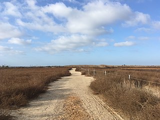
Newland House is an 1898 farmhouse in a midwestern adaptation of a Queen Anne architectural style in Huntington Beach, California, listed on the National Register of Historic Places. It is one of 123 historic places and districts on the National Register of Historic Places in Orange County, California. The Newland House is listed as the ninth historic place to receive a historical plaque from the Orange County Historical Commission in cooperation with the Orange County Board of Supervisors. The house has been identified as the site of the Tongva village of Lupukngna.

Puhú was a major residential village in the Santa Ana Mountains shared by the Tongva, Acjachemen, Payómkawichum, and Serrano near Santiago Peak. The village resided approximately 600m above sea level in the upper areas of the Black Star Canyon. The village was at its height from the years 1220-1770. The village retained its multi-seasonal occupancy and economic and political systems up until its destruction and a communal massacre in 1832.
Genga, alternative spelling Gengaa and Kengaa, was a Tongva and Acjachemen village located on Newport Mesa overlooking the Santa Ana River in the Newport Beach and Costa Mesa, California area which included an open site now referred to as Banning Ranch. Archaeological evidence dates the village at over 9,000 years old. Villagers were recorded as Gebit in Spanish Mission records. The village may have been occupied as late as 1829 or 1830.
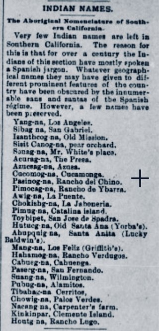
Hutuknga, alternative spelling Hotuuknga, was a large Tongva village located in the foothills along the present channel of the Santa Ana River in what is now Yorba Linda, California. People from the village were recorded in mission records as Jutucabit. Hutuknga was part of a series of villages along the Santa Ana River, which included Lupukngna, Genga, Pajbenga, and Totpavit. The Turnball Canyon area is sometimes falsely associated with Hutuknga.
Pajbenga, alternative spelling Pagbigna and Pasbengna, was a Tongva village located at Santa Ana, California, near the El Refugio Adobe, which was the home of José Sepulveda. It was one of the main villages along the Santa Ana River, including Lupukngna, Genga, Totpavit, and Hutuknga. People from the village were recorded in mission records as Pajebet, Pajbet, Pajbebet, and Pajbepet.
Totpavit, alternative spellings Totabit and possibly Totavet, was a Tongva village located in what is now Olive, California. The village was located between the Santa Ana River and Santiago Creek. It was part of a series of villages along the Santa Ana River, including Genga, Pajbenga, and Hutuknga.

Moyongna, alternatively spelled Moyonga, was a coastal Tongva village or landmark site located near the entrance of Newport Bay in Newport Beach, California near Corona del Mar. As a coastal village, the usage of te'aats was likely important to the village's people. Nearby coastal villages included Genga, located on Newport Mesa, and Lupukngna, located near the mouth of the Santa Ana River.

Alume was a large Acjachemen village located between Trabuco Creek and Tijeras Creek at Rancho Santa Margarita, California. The village was also recorded as Alaugna and as El Trabuco in San Juan Capistrano mission records, and is also referred to as Alauna, Aluna, and Alona.

