Corona del Mar, Newport Beach

Last updated
Corona del Mar
North Corona Del Mar CA photo Don Ramey Logan.jpg
Aerial view of Corona del Mar
Coordinates: 33°35′19″N117°52′44″W / 33.588633°N 117.878945°W / 33.588633; -117.878945
Country United States
State California
County Orange
City Newport Beach
Time zone UTC-8 (PST)
  Summer (DST) UTC-7 (PDT)
Zip code
92625

Corona del Mar (Spanish for "Crown of the Sea") [1] is a seaside neighborhood in the city of Newport Beach, California. It generally consists of all the land on the seaward face of the San Joaquin Hills south of Avocado Avenue to the city limits, as well as the development of Irvine Terrace, just north of Avocado. Corona del Mar is known for its beaches, tide pools, cliffside views and village shops. [2] Beaches in the area include Corona del Mar State Beach as well as Crystal Cove State Park south of Corona del Mar, accessible by paths winding down a steep hillside. [3] Corona del Mar has a representative to the Newport Beach City Council. Residents use a mailing address of Corona del Mar with the 92625 ZIP code.

Contents

History

The Tongva village or landmark site of Moyongna was located at or near Corona del Mar. Some researchers have placed the location at the Newporter Inn, while others have disputed this location. [4] [5]

The region of Corona Del Mar was initially purchased for $150,000 by James Irvine in 1875. [6] Almost 30 years later in 1904, the 700 acres of land was sold to Corona Del Mar's founder, George E. Hart. [7] The community of Corona Del Mar grew to establish its own post office on July 16, 1926, with Mrs. Edna L. Stuckey assuming duties as the first postmistress. A development consisting of unsold land in Corona del Mar was established in 1915 and named Balboa Palisades. [1]

The older area of Corona del Mar known as the Flower Streets consists mostly of closely spaced, free-standing, detached single-family houses of varying architecture, concentrated along Pacific Coast Highway (also known as "PCH" or State Route 1). Newer developments in Harbor View Hills consist of California ranch-style houses, many with expansive ocean views. Irvine Terrace is another neighborhood in Corona Del Mar located slightly north of Avocado, including a mix of newly developed homes as well as original mid-1950 homes many with incredible views of Balboa Island and Newport harbor. [8]

Demographics

Corona del Mar Cliffs in Newport Beach Corona del Mar Cliffs photo D Ramey Logan.jpg
Corona del Mar Cliffs in Newport Beach
Corona del Mar, Newport Beach CDM Newport Beach 2013 Photo D Ramey Logan.jpg
Corona del Mar, Newport Beach

As of the census of 2000, for Corona del Mar (which consists entirely of the 92625 ZIP code) there were 13,407 people, 6,885 households, and 3,957 families residing in the city. The population density was 1,997.8/km2. The racial makeup of the city was 88.9% White, 0.3% African American, 0.2% Native American, 5.1% Asian, 0.3% Pacific Islander, 0.7% from other races, and 1.1% from two or more races. Hispanic or Latino of any race were 5.9% of the population.

There were 6,885 households, out of which 17.9% had children under the age of 18 living with them, 47.9% were married couples living together, 5.1% had a female householder with no husband present, and 45.3% were non-families. 34.6% of all households were made up of individuals, and 11.8% had someone living alone who was 65 years of age or older. The average household size was 2.05 and the average family size was 2.63.

In the city the population was spread out, with 15.6% under the age of 18, 3.2% from 18 to 24, 31.4% from 25 to 44, 23.7% from 45 to 64, and 20.1% who were 65 years of age or older. The median age was 35 years. For every 100 females, there were 94.8 males. For every 100 females age 18 and over, there were 94.7 males.

The median income for a household in the city was $120,080, and the median income for a family was $150,323. Males had a median income of $99,000 versus $52,355 for females. The per capita income for the city was $96,704. About 5.0% of families and 3.8% of the population were below the poverty line, including 3.6% of those under age 18 and 5.0% of those age 65 or over.[ citation needed ]

Corona del Mar High School is located in the neighborhood of Eastbluff.

Points of interest

"Big Corona" Beach and Pirates Cove from Lookout Point Lookout Point 'Little Corona' Newport Harbor.JPG
"Big Corona" Beach and Pirates Cove from Lookout Point

There is a wide variety of landmarks and points of interest to visit in Corona Del Mar. Big Corona Beach is the larger of the two Corona Del Mar state beaches, stretching half a mile long. The botanical gardens at Sherman Library and Gardens is a popular landmark in Corona Del Mar, displaying a wide range of flowers, vegetation, and a green house.

The Oscar winning film, All Quiet on the Western Front was filmed in the very beginning of Corona Del Mar's days. [6]

It is the setting for the Fox series Arrested Development (mentioned by name in Season 2, Episode 14, "The Immaculate Election") as well as residence of Martine and Dustin Rhodes in the Dean Koontz novel False Memory .

The Lost Dogs paid tribute to Corona del Mar on their 2006 album, The Lost Cabin and the Mystery Trees , with the song "Only One Bum In Corona del Mar."

Main Beach in Corona del Mar served as the backdrop for part of the 2017 "Would You Ever" music video featuring Skrillex and Poo Bear.

The O.C. used places, such as Corona del Mar High School, in Corona del Mar as a reference point for the show.

Parking Policies

There is no municipal government conducted in Corona Del Mar which makes it a district of Newport Beach. [2] The parking policies in Corona Del Mar fall under Newport Beach parking policies and range from street parking to paid parking at state beach areas. Public parking is available in many areas, however in residential areas such as the flower streets, the city of Newport Beach have experienced parking deficits in high demand seasons. The implementing of pay meters has helped enforce time restrictions in high traffic, nonresidential areas of Corona Del Mar. [10] Beach park areas have a designated time between hours of 6am and 10pm 7 days a week when visitors are allowed to park and pay hourly. [3] Paid beach parking in Corona Del Mar is a state policy that is geared toward helping decrease overcrowding of residential parking areas.

Related Research Articles

<span class="mw-page-title-main">Greater Los Angeles</span> Metropolitan area centered around the city of Los Angeles in California, United States

Greater Los Angeles is the most populous metropolitan statistical area in the U.S. state of California, encompassing five counties in Southern California extending from Ventura County in the west to San Bernardino County and Riverside County in the east, with Los Angeles County in the center, and Orange County to the southeast. The Los Angeles–Anaheim–Riverside combined statistical area covers 33,954 square miles (87,940 km2), making it the largest metropolitan region in the United States by land area. With a population of 18.5 million in 2021, it is the second-largest metropolitan area in the United States. The contiguous urban area is 2,281 square miles (5,910 km2), whereas the remainder mostly consists of mountain and desert areas.

<span class="mw-page-title-main">Roberts County, South Dakota</span> County in South Dakota, United States

Roberts County is a county in the U.S. state of South Dakota. As of the 2020 census, the population was 10,280. Its county seat is Sisseton. The county was named either for S. G. Roberts of Fargo, North Dakota, or for Solomon Robar, an early local French fur trader. It was created on March 8, 1883, and fully organized by August 6 of that year. Its boundary was altered once, in 1885.

<span class="mw-page-title-main">Laguna Beach, California</span> City in California, United States

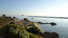
Laguna Beach is a city in Orange County, California, United States. Located in Southern California along the Pacific Ocean, this seaside resort city has a mild year-round climate, scenic coves, and environmental preservation efforts. The population in the 2020 census was 23,032.

<span class="mw-page-title-main">Laguna Niguel, California</span> City in California, United States

Laguna Niguel is a city in Orange County, California, United States. The name Laguna Niguel is derived from the words "Laguna" and "Niguili". As of the 2020 census, the population was 64,355. Laguna Niguel is located in the San Joaquin Hills in the southeastern corner of Orange County, close to the Pacific Ocean, and borders the cities of Aliso Viejo, Dana Point, Laguna Beach, Laguna Hills, Mission Viejo, and San Juan Capistrano.

<span class="mw-page-title-main">Newport Beach, California</span> City in Orange County, California

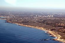
Newport Beach is a coastal city of about 85,000 in southern Orange County, California, United States. Newport Beach is known for swimming and sandy beaches. Newport Harbor once supported maritime industries; however, today it is used mostly for recreation. Balboa Island draws visitors with a waterfront path and easy access from the ferry to the shops and restaurants.

<span class="mw-page-title-main">Newport Coast, Newport Beach</span> Community of Newport Beach in California, United States

Newport Coast is a community south of the main body of the city of Newport Beach, California. It was a separate census-designated place in Orange County, California, United States, until 2001, when it was annexed into Newport Beach. Newport Beach, California's estimated population is 86,160 according to the most recent United States census estimates. Newport Beach, California is the 96th largest city in California based on official 2017 estimates from the US Census Bureau.

<span class="mw-page-title-main">Stanton, California</span> City in California, United States

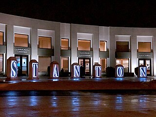
Stanton is a city in northern Orange County, California, United States, within the Los Angeles metropolitan area. The population was 37,962 at the 2020 United States Census. The city was incorporated in 1956 and operates under the council–manager form of government, providing a full range of municipal services. Stanton is bounded by Cypress on the west, Anaheim on the north, and east, and Garden Grove on the east and south.

<span class="mw-page-title-main">Grand Terrace, California</span> City in California, United States

Grand Terrace is a city in San Bernardino County, California, United States. The population was 12,040 at the 2010 census, up from 11,626 at the 2000 census. Grand Terrace is located between Highgrove and Colton, along the I-215 and Agua Mansa industrial corridors. The city is located between two mountain ridges: Blue Mountain to the east and the La Loma Hills to the west.

<span class="mw-page-title-main">Del Mar, California</span> City in California, United States

Del Mar is a beach town in San Diego County, California, located on the coast of the Pacific Ocean. Established in 1885 as a seaside resort, the city incorporated in 1959. The Del Mar Horse Races are hosted on the Del Mar racetrack every summer. The population was 3,954 at the 2020 census, down from 4,161 at the 2010 census.

<span class="mw-page-title-main">Solana Beach, California</span> City in California, United States

Solana Beach is a coastal city in San Diego County, California. Its population was at 12,941 at the 2020 U.S. Census, up from 12,867 at the 2010 Census.

<span class="mw-page-title-main">Rio del Mar, California</span> Census-designated Place in California, United States

Rio del Mar is an unincorporated village in Santa Cruz County, California. Rio del Mar is one of several small villages that form the unincorporated community of Aptos, California. Its population was 9,128 as of the 2020 United States census.

<span class="mw-page-title-main">Sunny Isles Beach, Florida</span> City in Florida

Sunny Isles Beach is a city located on a barrier island in northeast Miami-Dade County, Florida, United States. The city is part of the Miami metropolitan area of South Florida, and is bounded by the Atlantic Ocean on the east and the Intracoastal Waterway on the west. As of the 2020 census, it had a population of 22,342.

<span class="mw-page-title-main">Narragansett, Rhode Island</span> Town in Rhode Island, United States

Narragansett is a town in Washington County, Rhode Island, United States. The population was 14,532 at the 2020 census. However, during the summer months the town's population more than doubles to near 34,000. The town of Narragansett occupies a narrow strip of land running along the eastern bank of the Pettaquamscutt River to the shore of Narragansett Bay. It was separated from South Kingstown in 1888 and incorporated as a town in 1901.

<span class="mw-page-title-main">Beach City, Texas</span> City in Texas, United States

Beach City is a U.S. city in Chambers County, Texas, United States. The population was 3,221 at the 2020 census. It can now be considered as a part of Greater Houston.

<span class="mw-page-title-main">Orange Coast</span> Area in the Pacific Coast in Orange County, California

The Orange Coast is the string of cities and neighborhoods fronting the Pacific Coast in Orange County, California. From northwest to southeast, these cities are Seal Beach, Huntington Beach, Newport Beach, Laguna Beach, Dana Point and San Clemente. There are also two small unincorporated areas, a portion of Crystal Cove State Park between Newport Beach and Laguna Beach and Emerald Bay, a gated community located between two neighborhoods of Laguna Beach.

<span class="mw-page-title-main">Corona del Mar State Beach</span> Protected area

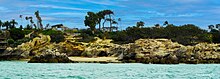
Corona del Mar State Beach is a protected beach in the state park system of California, United States. It is located in Corona del Mar, Newport Beach, and operated by the city of Newport Beach. The 30-acre (12 ha) park was established in 1947.

<span class="mw-page-title-main">Irvine, California</span> City in California, United States

Irvine is a master-planned city in southern Orange County, California, United States, in the Los Angeles metropolitan area. The Irvine Company started developing the area in the 1960s and the city was formally incorporated on December 28, 1971. The 66-square-mile (170 km2) city had a population of 307,670 at the 2020 census; it is the 63rd most populous city in the United States.

<span class="mw-page-title-main">Torrey Pines, San Diego</span> Neighborhood in San Diego, California

Torrey Pines is a community neighborhood of 2,600 acres (1,100 ha) in the northern coastal area of San Diego, California, residential with large areas of office space along I-5.

<span class="mw-page-title-main">Shady Cove, Oregon</span> City in Oregon, United States

Shady Cove is a city in Jackson County, Oregon, United States. The population was 2,904 at the 2010 census.

References

  1. 1 2 Salley, Harold E. (1977). History of California Post Offices, 1849-1976. The Depot. ISBN   0-9601558-1-3.
  2. 1 2 "Community". Corona Del Mar Chamber of Commerce. Retrieved 2022-08-23.
  3. 1 2 "Corona Del Mar SB". CA State Parks. Retrieved 2022-08-23.
  4. The Masterkey for Indian Lore and History, Volume 30. Southwest Museum. 1956. p. 155.
  5. Koerper, Henry Carl (1988). The Natural and Social Sciences of Orange County. Natural History Foundation of Orange County. p. 111. ISBN   9781879065017.
  6. 1 2 "History of Corona del Mar". Corona del Mar Historical Society. Retrieved 2022-08-23.
  7. "George Hart, Founder of CdM". Corona del Mar Historical Society. Retrieved 2022-08-23.
  8. "Irvine Terrace". Coastal Real Estate Group. Retrieved 2022-08-23.
  9. "China Cove in 1953". Corona del Mar Historical Society. Retrieved 2022-08-23.
  10. Turoff, S., & Linsenmayer, M. (2008, December 18). Municipal Parking Study – Corona del Mar. Corona Del Mar Parking Policy Plan. Retrieved August 22, 2022, from https://www.newportbeachca.gov/home/showpublisheddocument/970/635682493202100000

https://www.cdmchamber.com/

https://www.orangecounty.net/cities/CoronaDelMar.html

https://www.newportbeachca.gov/home

https://www.parks.ca.gov/?page_id=652