Stovepipe Wells is a way-station in the northern part of Death Valley, in unincorporated Inyo County, California.

The Santa Ana Mountains are a short peninsular mountain range along the coast of Southern California in the United States. They extend for approximately 61 miles (98 km) southeast of the Los Angeles Basin largely along the border between Orange and Riverside counties.

Trabuco Canyon is a small unincorporated community located in the foothills of the Santa Ana Mountains in eastern Orange County, California, and lies partly within the Cleveland National Forest.

New Almaden, known in Spanish as Nueva Almadén, is a historic community and former mercury mine in the Capitancillos Hills of San Jose, California, located at the southwestern point of Almaden Valley in South San Jose. New Almaden is divided into two parts: the mines and much of their immediate surroundings, including historic ghost town settlements in the Capintancillas, which together form the Almaden Quicksilver County Park, and the largely residential historic district surrounding the Casa Grande.

Silverado is an unincorporated community in Silverado Canyon, which is located in the Santa Ana Mountains in eastern Orange County, California. Portions of the town sit on a former Mexican land grant Rancho Lomas de Santiago. Silverado is located at the boundaries of Cleveland National Forest. The site is a California Historical Landmark, and is located near the village site of Puhú.
California's 19th congressional district is a congressional district in the U.S. state of California, currently represented by Democrat Jimmy Panetta.

Black Star Canyon is a remote mountain canyon in the Santa Ana Mountains, located in eastern Orange County, California. It is a watershed of the Santa Ana River. Black Star Canyon is a popular destination for mountain bikers as well as hikers due to its wild scenery. The California Historical Landmark associated with the canyon refers to the village of Puhú.
Rancho Santiago de Santa Ana was a 63,414-acre (256.63 km2) Spanish land concession in present-day Orange County, California, given by Spanish Alta California Governor José Joaquín de Arrillaga in 1810 to Jose Antonio Yorba and his nephew Pablo Peralta. The grant extended eastward from the Santa Ana River to the Santa Ana Mountains, with a length of more than 22 miles (35 km).
Santiago Canyon is a canyon and unincorporated community in South Orange County, California. According to the 2000 census, Santiago Canyon has several hundred residents living within its borders. Trabuco Canyon, Silverado Canyon, Modjeska Canyon and Williams Canyon are tributaries of Santiago Canyon. Santiago Creek flows northwest from the canyon, then west into the Santa Ana River. Neighborhoods in Santiago Canyon include Santiago Canyon Estates and Falcon View Estates. The landmark Cook's Corner motorcycle restaurant is also located within Santiago Canyon.

Havilah is an unincorporated community in Kern County, California. It is located in the mountains between Walker Basin and the Kern River Valley, 5 miles (8.0 km) south-southwest of Bodfish at an elevation of 3,136 feet (956 m).

Santiago Creek is a major watercourse in Orange County in the U.S. state of California. About 34 miles (55 km) long, it drains most of the northern Santa Ana Mountains and is a tributary to the Santa Ana River. It is one of the longest watercourses entirely within the county. The creek shares its name with Santiago Peak, at 5,687 ft (1,733 m) the highest point in Orange County, on whose slopes its headwaters rise.
Grass Creek is a ghost town in Summit County, Utah, United States. Lying some 8 miles (13 km) northeast of Coalville, it was once an important coal mining town. Grass Creek was inhabited circa 1860–1940.

Rancho Temescal was a farming outpost of Mission San Luis Rey de Francia, one of the 21 Franciscan missions established in California by Spain during the late 18th and early 19th centuries. The Mission was located on the coast where Oceanside, California is today. The Rancho was settled in 1819 by Leandro Serrano, and became the first non-native settlement within the boundaries of what would become Riverside County, California.
Corral Hollow, formed by Corral Hollow Creek, is a canyon partially located in Alameda County, with parts in San Joaquin County, 6.5 miles (10.5 km) southwest of Tracy, California. Corral Hollow Creek, formerly El Arroyo de los Buenos Ayres, from its source 1.9 miles (3.1 km) north of Mount Boardman, flows north 1.89 miles where it turns to flow west-northwest 8.5 miles (13.7 km) then turns abruptly east in the vicinity of Tesla to flow 5 miles (8.0 km) east where it turns again in a northeasterly direction for 6 miles (9.7 km) to the Delta-Mendota Canal in the San Joaquin Valley.

The place of Red Hill was designated a California Historic Landmark on June 20, 1935. Red Hill is in what is today North Tustin, California, Orange County. Red Hill has played an important part of history for the area. Red Hill is 347 feet tall, and 1,000 feet by 500 feet.

Manchester was a mining town in the Los Burros Mining District in the southern Big Sur region of Monterey County, California from about 1875 to 1895. The town was reached by a 20 miles (32 km) road from King City to Jolon. From Jolon travelers could ride or take a stage or wagon to the Wagon Caves, followed by a difficult 14 miles (23 km) trail over the steep Santa Lucia Mountains to the site, about 4 miles (6.4 km) inland of Cape San Martin. Prospecting began in the area in the 1850s.

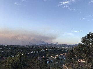
The Silverado Fire was a wildfire that burned in October and November 2020 in southern Orange County, California northeast of Irvine. The fire started on October 26 around 6:47 AM near Orange County Route S-18 and Silverado Canyon Road, fueled by strong Santa Ana winds gusting up to 80 miles per hour (130 km/h) and low humidity. Orange County Fire Authority Chief Brian Fennessy stated, "The winds were extraordinary even by Santa Ana standards. Fire spread is exceeding more than anything I've seen in my 44 years." The fire initially moved south from Loma Ridge toward the Orchard Hills, Northwood and Portola Springs communities of Irvine before moving southeast through Limestone Canyon and toward the communities of Foothill Ranch and Lake Forest. The fire burned in a path similar to that taken by the 2007 Santiago Fire, mostly through terrain that had not seen significant burning in the 13 years since that fire. 100% containment was announced on November 7, 2020.

Puhú was a major residential village in the Santa Ana Mountains shared by the Tongva, Acjachemen, Payómkawichum, and Serrano near Santiago Peak. The village resided approximately 600m above sea level in the upper areas of the Black Star Canyon. The village was at its height from the years 1220-1770. The village retained its multi-seasonal occupancy and economic and political systems up until its destruction and a communal massacre in 1832.

Gubserville was a historic stagecoach, mail, and teamster stop along the road between West San Jose and Saratoga in Santa Clara County, California, United States. The early settlement was named after Frank Gubser, a German immigrant who worked as a barber, saloon keeper, and served as the village's first and only postmaster since July 5, 1882. Gubserville ceased to exist when the post office discontinued operations in 1899. Today, the old ghost of Gubserville is marked by the California Historical Landmark #447.


