Related Research Articles
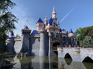
Anaheim is a city in northern Orange County, California, United States, part of the Greater Los Angeles area. As of the 2020 United States Census, the city had a population of 346,824, making it the most populous city in Orange County, the 10th-most populous city in California, and the 55th-most populous city in the United States. Anaheim is the second-largest city in Orange County in terms of land area, and is known for being the home of the Disneyland Resort, the Anaheim Convention Center, and two major league sports teams: the Los Angeles Angels of Major League Baseball (MLB) and the Anaheim Ducks of the National Hockey League (NHL).

Fullerton is a city located in northern Orange County, California, United States. As of the 2020 census, the city had a total population of 143,617.
Koreatown is on Garden Grove Boulevard between Beach Boulevard and Brookhurst Street in Garden Grove, Orange County, California. The Korean population in Orange County more than doubled between 1990 and 2010.
KFSH-FM is a commercial radio station that is licensed to La Mirada, California, and serves Orange County and southern Los Angeles County. The station is owned by Salem Media Group and has broadcast a contemporary Christian music (CCM) format since 2000. The station has studios in Glendale, with the transmitter based in the city of Orange. The branding refers to the ichthys, the ancient fish icon used by the Christian church since its birth during the time of the Roman Empire; the ichthys itself is part of the station logo.

The South Coast Metro is a district in Orange County, California within the cities of Santa Ana and Costa Mesa. The area is a dense mix of residential, office, and retail developments that spreads out from the South Coast Plaza mall. It forms part of the South Coast Plaza–John Wayne Airport edge city, a concentration of business, shopping, and entertainment outside a traditional central business district. The edge city's area is defined to include John Wayne Airport, the Irvine Business Complex (IBC), The District and The Market Place shopping centers, and the University of California, Irvine campus. This larger definition extends into Newport Beach, Irvine, and Tustin.
The Imperial Highway is a west-east thoroughfare in the counties of Los Angeles, Orange, Riverside, San Diego, and Imperial in the U.S. state of California. The main portion of the existing route begins at Vista Del Mar in Los Angeles near the Los Angeles International Airport and ends at the Anaheim–Orange city line at Via Escola where it becomes Cannon Street. Historically, the Imperial Highway extended from Vista Del Mar to Calexico, where a portion of the highway still exists. The original route was replaced with other highways, leading the older portions of the Imperial Highway to fall out of use.
Olive is an unincorporated parcel of about 32.67 acres (132,200 m2) in the city of Orange, located along Lincoln Avenue, between Eisenhower Park and Orange Olive Road.

California's 42nd congressional district is a U.S. congressional district in California. The district is currently represented by Democrat Robert Garcia.
Canyon High School is a traditional four-year high school located in the Anaheim Hills community in the city of Anaheim, California and is an International Baccalaureate school. It is located on 40 acres (160,000 m2) of land on Imperial Highway between the cross streets of Santa Ana Canyon Road and Nohl Ranch Road, and serves students in the Orange Unified School District. The school, which opened its doors in 1973, has a student population of 2,400. The school primarily serves the community of Anaheim Hills as well as parts of East Anaheim and Orange, and was designated a California Distinguished School in 2007 by the California Department of Education. The school's fight song is Washington and Lee Swing. The school is currently ranked as one of the top 1,000 high schools in the United States by Newsweek at number 128, a distinction given to less than 1% of high schools nationally. It is the 204th highest ranked school in the state of California.

Harbor Boulevard is a north–south road corridor in the counties of Los Angeles and Orange. One of the busiest routes in Orange County, the thoroughfare passes through some of the most densely populated areas in the region and carries about 8 percent of the county's bus riders. The route provides access for local residents to travel to work and for drivers travelling from Valley Boulevard in the City of Industry via Fullerton Road to Newport Beach.

Marine Corps Air Station Tustin is a former United States Navy and United States Marine Corps air station, located in Tustin, California.
West Anaheim is a district in Anaheim, California which extends from Euclid Street on the East to the city limits at Cypress on the West. West Anaheim is where most of the residential development occurred during the 1950s and the 1960s, after Disneyland opened in 1955.

Orange County International Auto Show is an annual event in Anaheim, California, that has been held since 1996. The show runs at the Anaheim Convention Center. In 2006 the former California International Auto Show has announced its name will change to the "Orange County International Auto Show". The show is presented by the Orange County Automobile Dealers Association.
Sunny Hills Performing Arts Center is a performing arts hall in Fullerton, California. It has a capacity for 360 people and regularly hosts concerts and is a venue for Sunny Hills High School. It is a notable venue for classical concerts in Orange County. Fullerton Friends of Music, the oldest chamber music society in Orange County, perform five concerts a year at the venue.
The following is a timeline of the history of the city of Anaheim, California, US.
Mineola is an unincorporated community in Lowndes County, in the U.S. state of Georgia.
Anaheim Town Square, is a 372,185-square-foot (34,577 m2) community shopping center, the largest center in East Anaheim, California which was built at the intersection of Anaheim-Olive Road and Placentia Avenue.
Chandler is an unincorporated community in Wayne Township, Jefferson County, Ohio, United States. It is located south of Bloomingdale at the intersection of Bloomingdale-Smithfield-Chandler Road and County Road 24, at 40°18′28″N80°48′15″W.
Orangefair Marketplace is a community shopping center in Fullerton, California which when built was one of the earliest large shopping centers in Orange County, California. along with Anaheim Plaza and Orange County Plaza. It is located at the southeast corner of Harbor Boulevard and Orangethorpe Avenue, a mile south of Fullerton's historic downtown.

Naval Air Station Los Alamitos Naval Outlying Landing Fields were a set airfield near Naval Air Station Los Alamitos to support the training of US Navy pilots during World War 2. The support airfields are called Naval Outlying Landing Field (NOLF). For the war, many new trained pilots were needed. The Naval Outlying Landing Fields provided a place for pilots to practice landing and take off without other air traffic. The remotes sites offered flight training without distractions. Most of the new pilots departed to the Pacific War after training. The Outlying Landing Fields had little or no support facilities. Naval Air Station Los Alamitos opened in 1942 and was transferred to the US Army in 1977 as Los Alamitos Army Airfield. Most of the Outlying fields closed in 1945, having completed the role of training new pilots. To open the needed Outlying Landing Fields quickly, the Navy took over local crop dusting and barnstorming airfields. Naval Air Station Los Alamitos was also called Los Alamitos Naval Reserve Air Base. During the war Marine Corps Air Station El Toro also used the outlying Landing Field. The Timm N2T Tutor was the most common plane used for training on the outlying landing fields.
References
- 1 2 U.S. Geological Survey Geographic Names Information System: Miraflores (historical)
- ↑ Miraflores (Orange County): Community Profile
- ↑ Gannett, Henry (1905). The Origin of Certain Place Names in the United States. U.S. Government Printing Office. p. 210.
33°48′15″N117°54′28″W / 33.80417°N 117.90778°W
| |||||||
| History | |||||||
| Areas | |||||||
| Municipal government | |||||||
| Primary and secondary schools |
| ||||||
| Colleges and universities |
| ||||||
| Culture | |||||||
| Points of interest | |||||||
| Transportation | |||||||
| Sports |
| ||||||

| | This Orange County, California–related article is a stub. You can help Wikipedia by expanding it. |