Las Flores, California

Last updated

Las Flores, California
Las Flores, California.jpg
Entrance sign for Las Flores along Oso Parkway
Orange County California Incorporated and Unincorporated areas Las Flores Highlighted.svg
Location of Las Flores in Orange County, California
Coordinates: 33°35′13″N117°37′39″W / 33.58694°N 117.62750°W / 33.58694; -117.62750
Country Flag of the United States (23px).png  United States
State Flag of California.svg  California
County Orange
Area
[1]
  Total2.028 sq mi (5.254 km2)
  Land2.028 sq mi (5.254 km2)
  Water0 sq mi (0 km2)  0%
Elevation
715 ft (218 m)
Population
  Total5,995
  Density3,000/sq mi (1,100/km2)
Time zone UTC−08:00 (Pacific)
  Summer (DST) UTC−07:00 (PDT)
ZIP Code
92688
Area code 949
FIPS code 06-40526
GNIS feature IDs 1853398, 2408577

Las Flores (Spanish for "The Flowers") is an unincorporated census-designated place (CDP) in Orange County, California, located adjacent to the City of Rancho Santa Margarita, California. The population was 5,971 at the 2010 census, up from 5,625 at the 2000 census. Las Flores does not have its own ZIP Code and is served by the same ZIP Code as adjacent Rancho Santa Margarita, 92688. [2] The Rancho Santa Margarita dog/skate park is located in the CDP and is served by the Orange County Sheriff's Dept. and Orange County Fire Authority. [3] [4] Although Las Flores lies in the land grant of Rancho Mission Viejo, it is named after the land grant about twenty-five miles (40 km) south Rancho Santa Margarita y Las Flores.

Contents

Geography

Las Flores is located near the intersection of Oso Parkway and Antonio Parkway in unincorporated southern Orange County, running several miles adjacent to Antonio Parkway and Oso Parkway. Las Flores is bordered by the city of Rancho Santa Margarita to the northwest, the census-designated place (CDP) Coto de Caza to the north, the CDP Ladera Ranch to the south, and the city of Mission Viejo to the west.

According to the United States Census Bureau, the CDP has a total area of 2.0 square miles (5.2 km2), all land.

Demographics

Historical population
CensusPop.Note
2000 5,625
2010 5,9716.2%
U.S. Decennial Census [5]


2010

At the 2010 census Las Flores had a population of 5,971. The population density was 2,943.7 inhabitants per square mile (1,136.6/km2). The racial makeup of Las Flores was 4,488 (75.2%) White (64.6% Non-Hispanic White), [6] 91 (1.5%) African American, 23 (0.4%) Native American, 780 (13.1%) Asian, 12 (0.2%) Pacific Islander, 261 (4.4%) from other races, and 316 (5.3%) from two or more races. Hispanic or Latino of any race were 984 people (16.5%). [7]

The whole population lived in households, no one lived in non-institutionalized group quarters and no one was institutionalized.

There were 1,916 households, 1,079 (56.3%) had children under the age of 18 living in them, 1,279 (66.8%) were opposite-sex married couples living together, 198 (10.3%) had a female householder with no husband present, 76 (4.0%) had a male householder with no wife present. There were 84 (4.4%) unmarried opposite-sex partnerships, and 12 (0.6%) same-sex married couples or partnerships. 257 households (13.4%) were one person and 27 (1.4%) had someone living alone who was 65 or older. The average household size was 3.12. There were 1,553 families (81.1% of households); the average family size was 3.47.

The age distribution was 2,029 people (34.0%) under the age of 18, 418 people (7.0%) aged 18 to 24, 1,885 people (31.6%) aged 25 to 44, 1,416 people (23.7%) aged 45 to 64, and 223 people (3.7%) who were 65 or older. The median age was 33.2 years. For every 100 females, there were 99.4 males. For every 100 females age 18 and over, there were 93.0 males.

There were 1,969 housing units at an average density of 970.7 per square mile, of the occupied units 1,326 (69.2%) were owner-occupied and 590 (30.8%) were rented. The homeowner vacancy rate was 0.7%; the rental vacancy rate was 5.6%. 4,469 people (74.8% of the population) lived in owner-occupied housing units and 1,502 people (25.2%) lived in rental housing units.

According to the 2010 United States Census, Las Flores had a median household income of $128,301, with 3.6% of the population living below the federal poverty line. [6]

2000

At the 2000 census there were 5,625 people, 1,936 households, and 1,486 families in the CDP. The population density was 2,816.0 inhabitants per square mile (1,087.3/km2). There were 1,999 housing units at an average density of 1,000.7 per square mile (386.4/km2). The racial makeup of the CDP was 78.17% White, 1.88% African American, 0.46% Native American, 10.22% Asian, 0.09% Pacific Islander, 4.21% from other races, and 4.96% from two or more races. Hispanic, of any race were 11.88%. [8]

Of the 1,936 households 51.8% had children under the age of 18 living with them, 67.9% were married couples living together, 6.7% had a female householder with no husband present, and 23.2% were non-families. 14.7% of households were one person and 0.7% were one person aged 65 or older. The average household size was 2.91 and the average family size was 3.31.

The age distribution was 32.4% under the age of 18, 5.9% from 18 to 24, 46.7% from 25 to 44, 12.4% from 45 to 64, and 2.5% 65 or older. The median age was 30 years. For every 100 females, there were 99.3 males. For every 100 females age 18 and over, there were 95.5 males.

The median household income was $89,978 and the median family income was $100,448. Males had a median income of $70,397 versus $46,029 for females. The per capita income for the CDP was $38,241. About 0.3% of families and 1.1% of the population were below the poverty line, including 0.8% of those under age 18 and none of those age 65 or over.

Served by Rancho Santa Margarita's zip code 92688. It is named in reference to Rancho Santa Margarita y Las Flores. It was established when Rancho Santa Margarita was unincorporated in the 1990s and was never officially annexed when RSM incorporated in 2000. [9]

Government

In the California State Legislature, Las Flores is in the 36th Senate District , represented by Republican Janet Nguyen, and in the 73rd Assembly District , represented by Democrat Cottie Petrie-Norris. [10]

In the United States House of Representatives, Las Flores is in California's 49th congressional district , represented by Democrat Mike Levin. [11]

Education

The CDP is served by Capistrano Unified School District.

Las Flores is the home to the adjoined campuses of Las Flores Elementary and Las Flores Middle School, as well as Tesoro High School.

See also

Related Research Articles

<span class="mw-page-title-main">Laton, California</span> Census-designated place in California, United States

Laton is a census-designated place (CDP) in Fresno County, California, United States. The population was 1,824 at the 2010 census, up from 1,236 at the 2000 census. Laton is located 23 miles (37 km) south-southeast of Fresno, at an elevation of 259 feet.

<span class="mw-page-title-main">Desert View Highlands, California</span> Census designated place in California, United States

Desert View Highlands is a census-designated place (CDP) in Los Angeles County, California, United States. The population was 2,360 at the 2010 census, up from 2,337 at the 2000 census. It is surrounded by the City of Palmdale.

<span class="mw-page-title-main">West Rancho Dominguez, California</span> Unincorporated community in California, United States

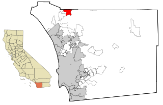
West Rancho Dominguez, formerly known as West Compton and also known as East Gardena, is an unincorporated census-designated place (CDP) located in southern Los Angeles County, California. Per the 2020 census, the population was 24,347. The community lies to the west of the city of Compton. The ZIP Codes encompassing the CDP area are 90220 & 90248.

<span class="mw-page-title-main">West Whittier-Los Nietos, California</span> Census-designated place in California, United States

West Whittier-Los Nietos is a census-designated place (CDP) in Los Angeles County, California, near the San Gabriel River and the San Gabriel River (I-605) Freeway. The population was 25,540 at the 2010 census, up from 25,129 at the 2000 census. The census area consists of separate unincorporated communities of Los Nietos and West Whittier.

<span class="mw-page-title-main">Le Grand, California</span> Census-designated place in California, United States

Le Grand is an unincorporated community and census-designated place (CDP) in Merced County, California, United States. Le Grand is 14 miles (23 km) east-southeast of Merced, the county seat at an elevation of 253 feet (77 m). The population was 1,592 at the 2020 census, down from 1,659 at the 2010 census.

<span class="mw-page-title-main">Aromas, California</span> Census-designated place in California, United States

Aromas is an unincorporated community and census-designated place (CDP) in Monterey County and San Benito County, California, United States. The population was 2,708 at the 2020 census.

<span class="mw-page-title-main">Coto de Caza, California</span> Place in California, United States

Coto de Caza is a census-designated place (CDP) and guard-gated private community in Orange County, California, United States. The population was 14,710 at the 2020 census.

<span class="mw-page-title-main">Rancho Santa Margarita, California</span> City in California, United States

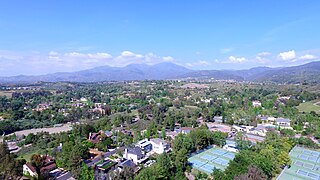
Rancho Santa Margarita is a city in Orange County, California, United States. One of Orange County's youngest cities, Rancho Santa Margarita is a master-planned community. The population was 47,853 at the 2010 census, up from 47,214 at the 2000 census. Although it is named for Rancho Santa Margarita y Las Flores, which was in San Diego County, the city limits fall within the borders of Rancho Mission Viejo. At 20 characters long, it is the longest city name in California.

<span class="mw-page-title-main">Bonsall, California</span> Census-designated place in California, United States

Bonsall is a census-designated place (CDP) in San Diego County, California. The population was 3,982 at the 2010 census, up from 3,401 at the 2000 census.

<span class="mw-page-title-main">Rainbow, California</span> Census designated place in California, United States

Rainbow is a census designated place (CDP) in northern San Diego County in the U.S. state of California. The population was 1,832 at the 2010 census, down from 2,026 at the 2000 census.

<span class="mw-page-title-main">Nipomo, California</span> Place in California, United States

Nipomo is an unincorporated town in San Luis Obispo County, California, United States. The population was 16,714 for the 2010 census and grew to 18,176 for the 2020 census. For statistical purposes, the United States Census Bureau has defined Nipomo as a census-designated place (CDP).

<span class="mw-page-title-main">West Menlo Park, California</span> Unincorporated community in California, United States

West Menlo Park is a census-designated place and an Unincorporated community in San Mateo County, California, located between the majority of City of Menlo Park, the Town of Atherton, the Sharon Heights neighborhood of Menlo Park and Stanford University. As of the 2020 census, the community had a population of 3,930.

<span class="mw-page-title-main">Mission Hills, Santa Barbara County, California</span> Census-designated place in the U.S. state of California

Mission Hills is a census-designated place (CDP) in Santa Barbara County, California, a short distance north of Lompoc on Highway 1. The population was 3,576 at the 2010 census, up from 3,142 at the 2000 census.

<span class="mw-page-title-main">Felton, California</span> Census-designated place in California, United States

Felton is a census-designated place (CDP) in Santa Cruz County, California, United States. The population was 4,489 as of 2020 census and according to the United States Census Bureau, the CDP has a total area of 4.6 square miles (12 km2), all of it land.

<span class="mw-page-title-main">Soquel, California</span> Census-designated place in California, United States

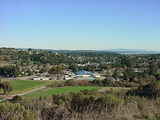
Soquel is an unincorporated town and census-designated place (CDP) in Santa Cruz County, California, located on the northern coast of Monterey Bay. The population was 9,980 at the 2020 census.

<span class="mw-page-title-main">Gerber-Las Flores, California</span> Unincorporated community in California, United States

Gerber-Las Flores is a former census-designated place (CDP) in Tehama County, California, United States. The population was 1,389 at the 2000 census.

<span class="mw-page-title-main">Rancho Calaveras, California</span> Census-designated place in California, United States

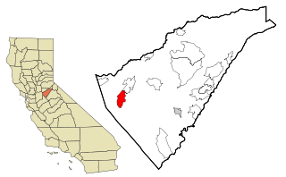
Rancho Calaveras is a census-designated place (CDP) in Calaveras County, California, United States. The population was 5,325 at the 2010 census, up from 4,182 at the 2000 census.

<span class="mw-page-title-main">El Rancho, New Mexico</span> Census-designated place in New Mexico, United States

El Rancho is a census-designated place (CDP) in Santa Fe County, New Mexico, United States. It is part of the Santa Fe, New Mexico Metropolitan Statistical Area. The population was 1,199 at the 2010 census.

<span class="mw-page-title-main">Stevenson Ranch, California</span> Unincorporated community in California, United States

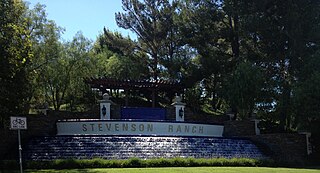
Stevenson Ranch is an unincorporated community in the Santa Clarita Valley of Los Angeles County, California. Stevenson Ranch is set in the foothills of the Santa Susana Mountains and lies west of Interstate 5 and the city of Santa Clarita. Stevenson Ranch encompasses about 6.4 square miles (17 km2). About 1,000 acres (4.0 km2) are set aside as parks, recreation areas, and open space. A master-planned community, it was approved by the county in 1987. The population was 20,178 at the time of the 2020 census. For statistical purposes, the Census Bureau has designated it a census-designated place (CDP).

<span class="mw-page-title-main">El Rancho, California</span> Census-designated place in California, United States

El Rancho is a census-designated place (CDP) in Tulare County, California. El Rancho sits at an elevation of 390 feet (120 m). The 2010 United States census reported El Rancho's population was 124.

References

  1. "2010 Census U.S. Gazetteer Files – Places – California". United States Census Bureau.
  2. GIS Maps of Rancho Santa Margarita CA Archived 2012-07-30 at archive.today
  3. OC Sheriff South Patrol Bureau Archived 2009-08-08 at the Wayback Machine
  4. OCFA Battalion 5 & 6 Area Map Archived 2008-05-29 at the Wayback Machine
  5. "Census of Population and Housing". Census.gov. Retrieved June 4, 2016.
  6. 1 2 https://web.archive.org/web/20120702005854/http://quickfacts.census.gov/qfd/states/06/0640526.html. Archived from the original on July 2, 2012.{{cite web}}: Missing or empty |title= (help)
  7. "2010 Census Interactive Population Search: CA - Las Flores CDP". U.S. Census Bureau. Archived from the original on July 15, 2014. Retrieved July 12, 2014.
  8. "U.S. Census website". United States Census Bureau . Retrieved January 31, 2008.
  9. Acceptabe City names for 92688
  10. "Statewide Database". Regents of the University of California. Archived from the original on February 1, 2015. Retrieved April 12, 2015.
  11. "California's 49th Congressional District - Representatives & District Map". Civic Impulse, LLC.