Palos Verdes Estates is a coastal city in Los Angeles County, California, United States, situated on the Palos Verdes Peninsula and neighboring Rancho Palos Verdes and Rolling Hills Estates. The city was master-planned by the noted American landscape architect and planner Frederick Law Olmsted Jr. The city is located along the Southern California coastline of the Pacific Ocean.

Rolling Hills is a city on the Palos Verdes Peninsula, in Los Angeles County, California, United States. Rolling Hills is a gated community with private roads with three entry gates. Homes are single-story 19th century California ranch or Spanish haciendas exemplified by architect Wallace Neff. Incorporated in 1957, Rolling Hills maintains a rural and equestrian character, with no traffic lights, multi-acre lots with ample space between homes, and wide equestrian paths along streets and property lines.

Torrance is a coastal city in the Los Angeles metropolitan area, located in southwest Los Angeles County, California, United States. The city is part of what is known as the South Bay region of the metropolitan area. A small section of the city, 1.5 miles (2.4 km), abuts the Pacific Ocean. Torrance has a moderate year-round climate with average rainfall of 12 inches (300 mm) per year. Torrance was incorporated in 1921, and at the 2020 census had a population of 147,067 residents. Torrance has a beachfront and has 30 parks located around the city. It is also the birthplace of the American Youth Soccer Organization (AYSO).

Rolling Hills Estates is a city in Los Angeles County, California, United States. On the northern side of the Palos Verdes Peninsula, facing Torrance, Rolling Hills Estates is mostly residential. Incorporated in 1957, Rolling Hills Estates has many horse paths. The population was 8,067 at the 2010 census, up from 7,676 at the 2000 census. In 2018, the population rose to 8,141, and the 2020 census counted 8,280 residents.

San Pedro is a neighborhood located within the South Bay and Harbor region of the City of Los Angeles, California, United States. Formerly a separate city, it consolidated with Los Angeles in 1909. The Port of Los Angeles, a major international seaport, is partially located within San Pedro. The district has grown from being dominated by the fishing industry, to a working-class community within the city of Los Angeles, to an increasingly dense and diverse community.

The Palos Verdes Peninsula is a peninsula and sub-region of the Los Angeles metropolitan area, located within southwestern Los Angeles County in the U.S. state of California. Located in the South Bay region, the peninsula contains a group of cities in the Palos Verdes Hills, including Palos Verdes Estates, Rancho Palos Verdes, Rolling Hills and Rolling Hills Estates, as well as the unincorporated community of Westfield/Academy Hill. The South Bay city of Torrance borders the peninsula on the north, the Pacific Ocean is on the west and south, and the Port of Los Angeles is east. As of the 2010 Census, the population of the Palos Verdes Peninsula is 65,008.

Frank Lloyd Wright Jr., commonly known as Lloyd Wright, was an American architect, active primarily in Los Angeles and Southern California. He was a landscape architect for various Los Angeles projects (1922–1924), provided the shells for the Hollywood Bowl (1926–1928), and produced the Swedenborg Memorial Chapel at Rancho Palos Verdes, California (1946–1971). His name is frequently confused with that of his more famous father, Frank Lloyd Wright.
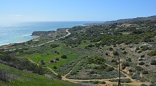
The Portuguese Bend region is the largest area of natural vegetation remaining on the Palos Verdes Peninsula, in Los Angeles County, California. Though once slated for development including the projected route of Crenshaw Boulevard, the area is geologically unstable and is unsuitable for building.
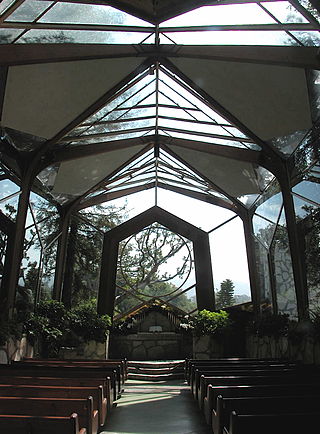
Wayfarers Chapel, or "The Glass Church" was a chapel located in Rancho Palos Verdes, California. The chapel had unique organic architecture sited on a bluff above the Pacific Ocean. Affiliated with the Swedenborgian Church of North America, it serves as a memorial to the 18th-century scientist and theosopher Emanuel Swedenborg.
Palos Verdes Peninsula Unified School District (PVPUSD) is a school district headquartered in Palos Verdes Estates, California with facilities in all four cities of the Palos Verdes Peninsula.

Rancho de los Palos Verdes was a 31,629-acre (128.00 km2) Mexican land grant in present-day Los Angeles County, California given in 1846 by Governor Pío Pico to José Loreto and Juan Capistrano Sepulveda. The name means "ranch of the green trees". The grant encompassed the present-day cities of the Palos Verdes Peninsula, as well as portions of San Pedro and Torrance.
Eric Lloyd Wright was an American architect, son of Frank Lloyd Wright Jr. and the grandson of the famed Frank Lloyd Wright.

Frank Arthur Vanderlip Sr. was an American banker and journalist. He was president of the National City Bank of New York from 1909 to 1919, and Assistant Secretary of the Treasury from 1897 to 1901. Vanderlip is known for his part in founding the Federal Reserve System and for founding the first Montessori school in the United States, the Scarborough School and the group of communities in Palos Verdes, California.
The Palos Verdes Hills are a low mountain range on the southwestern coast of Los Angeles County, California. They sit atop the Palos Verdes Peninsula, a sub-region of the Los Angeles metropolitan area.

Riverside County is a county located in the southern portion of the U.S. state of California. As of the 2020 census, the population was 2,418,185, making it the fourth-most populous county in California and the 10th-most populous in the United States. The name was derived from the city of Riverside, which is the county seat.

The Palos Verdes Peninsula Land Conservancy (PVPLC) is a non-profit organization that is based on the Palos Verdes Peninsula in southwestern Los Angeles County, California.
Miraleste High School was a public high school of the Palos Verdes Peninsula Unified School District (PVPUSD), located in Rancho Palos Verdes, California, in the Los Angeles metropolitan area.

Jurupa Valley is a city in the northwest corner of Riverside County, California, United States. It was the location of one of the earliest non-native settlements in the county, Rancho Jurupa. The Rancho was initially an outpost of the Mission San Gabriel Arcángel, then a Mexican land grant in 1838. The name is derived from a Native American village that existed in the area prior to the arrival of Europeans.

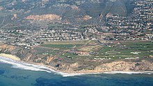
Trump National Golf Club, Los Angeles is a public golf club in Rancho Palos Verdes, California with a 7,242-yard (6,622 m) course designed by Pete Dye and Donald J. Trump Signature Design. It is owned by The Trump Organization.

Narcissa Cox Vanderlip, née Mabel Narcissa Cox (1879-1966) was an American suffragist.