Vincent, California

Last updated

Vincent, California
Vincent, California.png
LA County Incorporated Areas Vincent highlighted.svg
Location of Vincent in Los Angeles County, California.
Usa edcp location map.svg
Red pog.svg
Vincent, California
Location in the United States
Coordinates: 34°5′55″N117°55′28″W / 34.09861°N 117.92444°W / 34.09861; -117.92444
Country Flag of the United States.svg United States
State Flag of California.svg  California
County Flag of Los Angeles County, California.svg Los Angeles
Area
[1]
  Total1.471 sq mi (3.809 km2)
  Land1.471 sq mi (3.809 km2)
  Water0 sq mi (0 km2)  0%
Elevation
3,225 ft (983 m)
Population
 (2010)
  Total15,922
  Density11,000/sq mi (4,200/km2)
Time zone UTC-8 (PST)
  Summer (DST) UTC-7 (PDT)
ZIP code
91702, 91722, 91790
Area code 626
FIPS code 06-82814
GNIS feature ID1661642

Vincent (sometimes referred to as East Irwindale)[ citation needed ] is a census-designated place (CDP) in the central San Gabriel Valley, in Los Angeles County, California, United States. The city name and zipcode for addresses south of Arrow Highway is Covina and 91722, respectively, and Azusa and 91702 for addresses north of Arrow Highway. The population was 15,922 at the 2010 census, up from 15,097 at the 2000 census. Vincent is named after Vincent Avenue,[ citation needed ] which passes through the community.

Contents

Geography

Vincent is located at 34°5′55″N117°55′28″W / 34.09861°N 117.92444°W / 34.09861; -117.92444 (34.098555, -117.924395). [2]

According to the United States Census Bureau, the CDP has a total area of 1.5 square miles (3.9 km2), all land.

Demographics

Historical population
CensusPop.Note
1990 13,713
2000 15,09710.1%
2010 15,9225.5%
sources: [3] [4]

2010

At the 2010 census Vincent had a population of 15,922. The population density was 10,827.3 inhabitants per square mile (4,180.4/km2). The racial makeup of Vincent was 8,670 (54.5%) White (15.0% Non-Hispanic White), [5] 312 (2.0%) African American, 146 (0.9%) Native American, 1,128 (7.1%) Asian, 31 (0.2%) Pacific Islander, 4,857 (30.5%) from other races, and 778 (4.9%) from two or more races. Hispanic or Latino of any race were 11,921 persons (74.9%). [6]

The census reported that 15,899 people (99.9% of the population) lived in households, 18 (0.1%) lived in non-institutionalized group quarters, and 5 (0%) were institutionalized.

There were 3,900 households, 2,063 (52.9%) had children under the age of 18 living in them, 2,367 (60.7%) were opposite-sex married couples living together, 661 (16.9%) had a female householder with no husband present, 361 (9.3%) had a male householder with no wife present. There were 217 (5.6%) unmarried opposite-sex partnerships, and 22 (0.6%) same-sex couples or partnerships. There were 364 households (9.3%) consisting of one person, and 149 (3.8%) had someone living alone who was 65 or older. The average household size was 4.08. There were 3,389 families (86.9% of households); the average family size was 4.21.

The age distribution was 4,536 people (28.5%) under the age of 18, 1,823 people (11.4%) aged 18 to 24, 4,488 people (28.2%) aged 25 to 44, 3,656 people (23.0%) aged 45 to 64, and 1,419 people (8.9%) who were 65 or older. The median age was 32.4 years. For every 100 females, there were 98.9 males. For every 100 females age 18 and over, there were 97.9 males.

There were 4,016 housing units at an average density of 2,731.0 per square mile, of the occupied units 3,085 (79.1%) were owner-occupied and 815 (20.9%) were rented. The homeowner vacancy rate was 1.1%; the rental vacancy rate was 4.9%. Most of the population, 12,261 people (77.0%), lived in owner-occupied housing units; 3,638 people (22.8%) lived in rental housing units.

2000

In the census [7] of 2000, there were 15,097 people, 3,804 households, and 3,267 families living in the CDP. The population density was 10,039.3 inhabitants per square mile (3,876.2/km2). There were 3,879 housing units at an average density of 2,579.5 per square mile (996.0/km2). The racial makeup of the CDP was 51.74% White, 2.67% African American, 1.27% Native American, 6.86% Asian, 0.08% Pacific Islander, 31.80% from other races, and 5.58% from two or more races. Hispanic or Latino of any race were 64.41% of the population.

Of the 3,804 households 49.1% had children under the age of 18 living with them, 63.4% were married couples living together, 14.7% had a female householder with no husband present, and 14.1% were non-families. 10.3% of households were one person and 4.8% were one person aged 65 or older. The average household size was 3.97 and the average family size was 4.17.

The age distribution was 33.3% under the age of 18, 10.5% from 18 to 24, 31.1% from 25 to 44, 17.9% from 45 to 64, and 7.2% 65 or older. The median age was 30 years. For every 100 females, there were 97.7 males. For every 100 females age 18 and over, there were 97.0 males.

The median household income was $52,349 and the median family income was $52,086. Males had a median income of $34,075 versus $28,895 for females. The per capita income for the CDP was $15,522. About 7.3% of families and 9.8% of the population were below the poverty line, including 13.2% of those under age 18 and 6.5% of those age 65 or over.

Politics

In the state legislature Vincent is located in the 24th Senate District, represented by Democrat Gloria Romero, and in the 57th Assembly District, represented by Democrat Edward P. Hernandez. Federally, Vincent is located in California's 32nd congressional district, which is represented by Democrat Grace Napolitano.

Education

Vincent is divided between Azusa Unified School District and Covina-Valley Unified School District. [8]

Related Research Articles

<span class="mw-page-title-main">East Whittier, California</span> Unincorporated community in California, United States

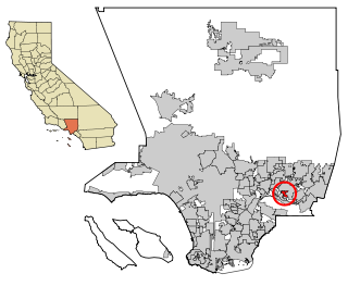
East Whittier is an unincorporated community in Los Angeles County, California, United States. The population was 9,757 at the 2010 census, up from 9,538 at the 2000 census. For statistical purposes, the United States Census Bureau has defined this community as a census-designated place (CDP). The name was changed from East La Mirada in 2012, likely due to its precise location in relation to the city of Whittier. The previous delineation of East Whittier CDP occurred during the 1960 census, when the area recorded a population of 19,884.

<span class="mw-page-title-main">Valinda, California</span> Census-designated place in California, United States

Valinda is a census-designated place (CDP) in the San Gabriel Valley, in Los Angeles County, California, in the United States. At the 2010 census, the population was 22,822, up from 21,776 at the 2000 census.

<span class="mw-page-title-main">Homeland, California</span> Census-designated place in California, United States

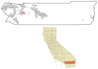
Homeland is a census-designated place (CDP) in Riverside County, California, United States. The population was 5,969 at the 2010 census, up from 3,710 at the 2000 census.

<span class="mw-page-title-main">Valle Vista, California</span> Census-designated place in California, United States

Valle Vista is a census-designated place (CDP) in Riverside County, California, United States and is located in the San Jacinto Valley. Some areas of Valle Vista are considered to be part of both unincorporated San Jacinto and Hemet but have yet to be incorporated. The population was 11,036 at the 2010 census, up from 8,356 at the 2000 census.

<span class="mw-page-title-main">Winchester, California</span> Census-designated place in California, United States

Winchester is a census-designated place (CDP) in Riverside County, California, USA. As of the 2010 census, the CDP had a total population of 2,534, up from 2,155 at the 2000 census.

<span class="mw-page-title-main">Mountain View Acres, California</span> Census-designated place in California, United States

Mountain View Acres is a census-designated place (CDP) in the Victor Valley of the Mojave Desert, within San Bernardino County, California.

<span class="mw-page-title-main">Camp Pendleton South, California</span> Census-designated place in California, United States

Camp Pendleton South is a census-designated place (CDP) in San Diego County, California, located at the southwest corner of the Marine Corps Base Camp Pendleton. The population was 10,616 at the 2010 census, up from 8,854 at the 2000 census. Much of the population are residents of Camp Pendleton barracks situated in the area, as well as housing communities for married Marine and Navy personnel and their families. It, along with Camp Pendleton Mainside CDP, is one of two CDPs on the base.

<span class="mw-page-title-main">Hidden Meadows, California</span> Census designated place in California, United States

Hidden Meadows is a census-designated place (CDP) near Escondido in San Diego County, California. The population was 3,485 at the 2010 census, up from 3,463 at the 2000 census.

<span class="mw-page-title-main">Broadview Park, Florida</span> CDP in Florida, United States

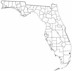
Broadview Park is a census-designated place (CDP) in Broward County, Florida, United States. The population was 7,670 at the 2020 census.

<span class="mw-page-title-main">Paukaa, Hawaii</span> Census-designated place in Hawaii, U.S.

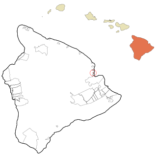
Paukaʻa is a census-designated place (CDP) in Hawaii County, Hawaii, United States. The population was 425 at the 2010 census, down from 495 at the 2000 census. The ZIP code is 96720.

<span class="mw-page-title-main">Kalaheo, Hawaii</span> Census-designated place in Hawaii, United States

Kalāheo is an unincorporated community and census-designated place (CDP) in Kauaʻi County, island of Kauaʻi, Hawaiʻi, United States. The population was 4,996 at the 2020 census, up from 3,913 at the 2000 census.

<span class="mw-page-title-main">Greater Landover, Maryland</span> Former census-designated place in Maryland

Greater Landover was a census-designated place (CDP) in Prince George's County, Maryland, United States, during the 2000 census. The population was 22,900 at that time. As of 2007, the rough estimate given by the census was at 22,665. For the 2010 U.S. Census, the area was designated the Landover CDP.

<span class="mw-page-title-main">China Lake Acres, California</span> Census-designated place in California, United States

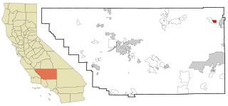
China Lake Acres is a census-designated place (CDP) in Kern County, California, United States. The population was 1,876 at the 2010 census, up from 1,761 at the 2000 census.

<span class="mw-page-title-main">Society Hill, Middlesex County, New Jersey</span> Populated place in Middlesex County, New Jersey, US

Society Hill is an unincorporated community and census-designated place (CDP) located within Piscataway Township, in Middlesex County, in the U.S. state of New Jersey. As of the 2010 United States Census, the CDP's population was 3,829.

<span class="mw-page-title-main">Mattydale, New York</span> Census-designated place in New York, United States

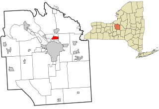
Mattydale is a hamlet in Onondaga County, New York, United States. The population was 6,446 at the 2010 census.

<span class="mw-page-title-main">Greentown, Ohio</span> Census-designated place in Ohio, United States

Greentown is a census-designated place in northern Stark County, Ohio, United States. The population was 3,382 at the 2020 census. It is part of the Canton–Massillon metropolitan area.

<span class="mw-page-title-main">Startex, South Carolina</span> CDP in South Carolina, United States

Startex is a census-designated place (CDP) in Spartanburg County, South Carolina, United States. The population was 859 at the 2010 census. The area was originally known as Tucapau, named after the mill that was built there in 1896. In 1936, Walter Montgomery Sr. bought the mill and changed its name to Startex—the brand name of household textiles produced at the plant. The mill ceased operations in 1998 and was mostly dismantled in 1999.

<span class="mw-page-title-main">Mirrormont, Washington</span> Census-designated place in Washington, United States

Mirrormont is a census-designated place (CDP) in King County, Washington, United States, south of Issaquah. The population was 3,858 at the 2020 census. Within the last decade, the area has seen a shift in development as larger homes have been constructed in Cedar Grove, the Highlands at Tiger Mountain and Mirrormont.

<span class="mw-page-title-main">Milton (CDP), Vermont</span> Census-designated place in Vermont, United States

Milton is an unincorporated village within the town of Milton in Chittenden County, Vermont, United States. The village disincorporated in 2003 and became a census-designated place (CDP) in 2008. As of the 2020 census the population was 3,804, out of a population of 10,723 for the entire town.

<span class="mw-page-title-main">Searles Valley, California</span> Census-designated place in California, United States

Searles Valley is a census-designated place (CDP) in the Searles Valley of the Mojave Desert, in northwestern San Bernardino County, California.

References

  1. "2010 Census U.S. Gazetteer Files – Places – California". United States Census Bureau.
  2. "US Gazetteer files: 2010, 2000, and 1990". United States Census Bureau. February 12, 2011. Retrieved April 23, 2011.
  3. "Census of Population and Housing (1790-2000)". U.S. Census Bureau . Retrieved July 17, 2010.
  4. United States Census [ dead link ] US Census Bureau
  5. Quick facts from the US Census Archived 2012-04-18 at the Wayback Machine
  6. "2010 Census Interactive Population Search: CA - Vincent CDP". U.S. Census Bureau. Archived from the original on July 15, 2014. Retrieved July 12, 2014.
  7. "U.S. Census website". United States Census Bureau . Retrieved January 31, 2008.
  8. "2020 CENSUS - SCHOOL DISTRICT REFERENCE MAP: Los Angeles County, CA" (PDF). U.S. Census Bureau. p. 11 (PDF p. 12/19). Retrieved November 25, 2023.