Monrovia is the fourth-oldest general-law city in Los Angeles County and the L.A. Basin (after Los Angeles, Santa Monica, and Pasadena, all now charter cities[6]). Incorporated in 1887, it has grown from a sparse community of orange ranches to a residential community of over 37,000.
In 1771, Franciscans established the Mission San Gabriel Arcangel in the San Gabriel Valley. The mission continued after Mexican independence in 1822. In 1833, the Mexican Congress initiated secularization of the missions in Alta California, to begin seizure of mission properties for sale to private rancho grantees.
In the mid-19th century, most of Rancho Azusa de Duarte was subdivided and sold by Duarte to settle his debts. Some of those parcels became part of the ranch of William N. Monroe, Monrovia's eponym.
Pacific Electric in Monrovia, 1903
Rancho Santa Anita changed hands several times before the multimillionaire, silver baron and rancher E.J. "Lucky" Baldwin acquired it in 1875. That same year his Los Angeles Investment Company began subdividing and selling parcels from many of his ranchos. In 1883, 240 acres (970,000 m2) of Rancho Santa Anita were sold to Monroe for $30,000. Additional parcels of Rancho Santa Anita were sold to Edward F. Spence, John D. Bicknell, James F. Crank, and J.F. Falvey.
The completion of the Los Angeles and San Gabriel Valley Railroad in 1887, later sold to the Santa Fe (which would run through Monrovia) and Southern Pacific railroads to Southern California brought new people looking for homes and investment opportunities. With this in mind, Monroe, Spence, Bicknell, Crank, and Falvey combined their land under the business name of the Monrovia Land and Water Company in 1886, centered at Orange (now Colorado Boulevard) and Myrtle Avenues; the first tract extended from Magnolia Avenue on the west to Charlotte Avenue (Canyon Boulevard) on the east, a half block south of Walnut on the south and a half block north of Lime on the north.[7] The subdivision was subdivided into 600 500-foot (150m) by 160-foot (49m) (1.84 acre) lots and sold.
The town was incorporated in 1887 under the leadership of prohibitionists who wished to control the arrival of an unwelcome saloon. The newly formed government's first order of business was to pass a tippler's law, prohibiting the sale of alcohol.
In 1903, the Monrovia News was established. The same year, the Pacific Electric was opened, providing transportation to and from Los Angeles, making it possible for Monrovia homeowners to work in Los Angeles.
Monrovia, 1914 (Myrtle Avenue, looking north)
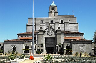
In 1905, Carnegie funds became available and, with the help of the Board of Trade (forerunner to the Chamber of Commerce) and the Monrovia Women's Club, a bond issue was passed to purchase the Granite Bank Building to be used as a city hall, and to acquire property for a public park. The Granite Building has served as the city hall, fire and police department facilities since 1961 and the fire department since 1974. In 1956, the old Carnegie library building was torn down and a new library was constructed. In March 2007, a new library was voted on by the people of Monrovia. It won with 70% yes votes. The library now has 190,000 books, a heritage room for historical documents, and areas for children, teens, and adults.[8]
In 1930, the Monrovia Airport, also known as the Foothill Flying Club, was commercially established. The small airstrip claimed to have had 12,000 paying customers use the airfield in 1932 and on May 19, 1938, the first airmail flight took off from Monrovia Airport. Ownership of the airport changed hands several times while it was in operation; pilots remembered it as "the friendliest little airport in the country." Apart from usage by Riley Brothers, TWA Captain and former airshow pilot Kalman Irwin, and Pancho Barnes, the airfield is well known for its use as a movie-filming location. The first movie filmed at the Monrovia Airport was The Fighting Pilot. Other films shot at the airfield include 20,000 Men a Year, The Great Plane Robbery, and most notably, The Big Noise, featuring Laurel and Hardy. The 35-acre airfield, used as a runway as well as an airplane repair and storage service, was forced to close in 1953 after being sold to Consolidated Engineering Corporation for redevelopment as a result of increased land values.[9]
Monrovia was the home to the precursor to McDonald's. In 1937, Patrick McDonald opened a food stand on Huntington Drive (Route 66) near the old Monrovia Airport called "The Airdrome" (hamburgers were ten cents, and all-you-can-drink orange juice was five cents); it remained there until 1940, when he and his two sons, Maurice and Richard, moved the building 40 miles (64km) east to San Bernardino to the corner of West 14th Street and 1398 North E Street, renaming it "McDonald's".
According to the United States Census Bureau, the city has an area of 35.5 square kilometers (13.7sqmi). 13.6 square miles (35km2) of it is land and 0.1 square miles (0.26km2) of it (0.79%) is water.[10]
Wildlife is abundant in the adjacent San Gabriel Mountains, including mammals like black bears, bobcats, coyotes, gray foxes, mountain lions, and mule deer, many of which roam area neighborhoods and visit backyards.[11] In 2024, a mother black bear and her young cubs began regularly visiting a home in Monrovia situated close to the mountains to cool-off and play in the property's swimming pool. By May, the bear family had become such regular visitors, with the homeowners posting numerous videos online, that it was reported on by multiple local, national and international news outlets, including Sky News Australia.[12]
The 2010 United States Census[14] reported that Monrovia had a population of 36,590. The population density was 2,668.1 inhabitants per square mile (1,030.2/km2). The racial makeup of Monrovia was 21,932 (59.9%) White (41.1% Non-Hispanic White),[15] 4,107 (11.2%) Asian, 2,500 (6.8%) African American, 279 (0.8%) Native American, 76 (0.2%) Pacific Islander, 5,818 (15.9%) from other races, and 1,878 (5.1%) from two or more races. Hispanic or Latino of any race were 14,043 persons (38.4%).
The census reported that 36,434 people (99.6% of the population) lived in households, 61 (0.2%) lived in non-institutionalized group quarters, and 95 (0.3%) were institutionalized.
There were 13,762 households, out of which 4,725 (34.3%) had children under the age of 18 living in them, 6,295 (45.7%) were opposite-sex married couples living together, 2,073 (15.1%) had a female householder with no husband present, 778 (5.7%) had a male householder with no wife present. There were 793 (5.8%) unmarried opposite-sex partnerships, and 131 (1.0%) same-sex married couples or partnerships. 3,649 households (26.5%) were made up of individuals, and 1,276 (9.3%) had someone living alone who was 65 years of age or older. The average household size was 2.65. There were 9,146 families (66.5% of all households); the average family size was 3.24.
The population was spread out, with 8,514 people (23.3%) under the age of 18, 3,084 people (8.4%) aged 18 to 24, 10,733 people (29.3%) aged 25 to 44, 10,018 people (27.4%) aged 45 to 64, and 4,241 people (11.6%) who were 65 years of age or older. The median age was 37.9 years. For every 100 females, there were 91.6 males. For every 100 females age 18 and over, there were 87.0 males.
There were 14,473 housing units at an average density of 1,055.4 per square mile (407.5/km2), of which 6,809 (49.5%) were owner-occupied, and 6,953 (50.5%) were occupied by renters. The homeowner vacancy rate was 1.3%; the rental vacancy rate was 4.9%. 18,478 people (50.5% of the population) lived in owner-occupied housing units and 17,956 people (49.1%) lived in rental housing units.
According to the 2010 United States Census, Monrovia had a median household income of $71,768, with 9.8% of the population living below the federal poverty line.[15]
2000
As of the census[16] of 2000, there were 36,929 people, 13,502 households, and 9,086 families residing in the city. The population density was 2,686.5 inhabitants per square mile (1,037.3/km2). There were 13,957 housing units at an average density of 1,015.3 per square mile (392.0/km2). The racial makeup of the city was 62.92% White, 8.67% African American, 7.02% Asian, 0.87% Native American, 0.13% Pacific Islander, 15.61% from other races, and 4.77% from two or more races. Hispanic or Latino of any race were 35.24% of the population.
There were 13,502 households, out of which 35.4% had children under the age of 18 living with them, 46.4% were married couples living together, 15.4% had a female householder with no husband present, and 32.7% were non-families. 26.0% of all households were made up of individuals, and 8.8% had someone living alone who was 65 years of age or older. The average household size was 2.71 and the average family size was 3.29.
In the city, the age distribution of the population shows 27.4% under the age of 18, 8.0% from 18 to 24, 34.0% from 25 to 44, 20.2% from 45 to 64, and 10.4% who were 65 years of age or older. The median age was 34 years. For every 100 females, there were 92.2 males. For every 100 females age 18 and over, there were 87.6 males.
The median income for a household in the city was $45,375, and the median income for a family was $49,703. Males had a median income of $41,039 versus $32,259 for females. The per capita income for the city was $21,686. About 9.7% of families and 13.1% of the population were below the poverty line, including 18.3% of those under age 18 and 9.7% of those age 65 or over.
Mexican (27.0%) and German (7.9%) were the most common ancestries. Mexico (48.1%) and the Philippines (8.6%) were the most common foreign places of birth.[17]
Newspapers with offices in Monrovia include the San Gabriel Valley Tribune, which publishes community news, and Monrovia Weekly, a community newspaper. Public access television is provided by KGEM-TV, which is available primarily to cable viewers, with some content online.[23]
Infrastructure
Transportation
Monrovia Trolley Bus in front of the Krikorian Theater (2005)
In 2016, Metro opened a new at-grade light rail station in Monrovia, Monrovia station, at the intersection of Myrtle Avenue and Duarte Road. It is served by the Metro A Line.[24] It is at the location of the former Santa Fe Depot, which still stands.[25]
Los Angeles County, officially the County of Los Angeles, and sometimes abbreviated as L.A. County, is the most populous county in the United States, with 9,861,224 residents estimated in 2022. Its population is greater than that of 40 individual U.S. states. Comprising 88 incorporated cities and many unincorporated areas within a total area of 4,083 square miles (10,570 km2), it is home to more than a quarter of Californians and is one of the most ethnically diverse U.S. counties. The county's seat, Los Angeles, is the second most populous city in the United States and the most populous city in California, with 3,822,238 residents estimated in 2022. It is also known for being the home of the American film and television industry, a distinction it has held since the early 20th century which has given the county global prominence.
Upland is a city in San Bernardino County, California, United States on the border with neighboring Los Angeles County. The municipality is located at an elevation of 1,242 feet (379 m). As of the 2020 census, the city had a population of 79,040, up from 73,732 at the 2010 census.
Arcadia is a city in Los Angeles County, California, United States, located about 13 miles (21 km) northeast of downtown Los Angeles in the San Gabriel Valley and at the base of the San Gabriel Mountains. It contains a series of adjacent parks consisting of the Santa Anita Park racetrack, the Los Angeles County Arboretum and Botanic Garden, and Arcadia County Park. The city had a population of 56,364 at the 2010 census, up from 53,248 at the 2000 census. The city is named after Arcadia, Greece.
Azusa is a city in the San Gabriel Valley region of Los Angeles County, California United States at the foot of the San Gabriel Mountains located 20 miles (32 km) east of downtown Los Angeles.
Baldwin Park is a city located in the central San Gabriel Valley region of Los Angeles County, California, United States. As of the 2020 census, the population was 72,176, down from 75,390 at the 2010 census.
Bradbury is a city in the San Gabriel Valley region of Los Angeles County, California, United States. It is located in the foothills of the San Gabriel Mountains below Angeles National Forest. Bradbury is bordered by the city of Monrovia to the west and south, and Duarte to the south and east. The population was 1,048 at the 2010 census, up from 855 at the 2000 census. The city has three distinct areas—the Bradbury Estates, which is a gated community consisting of 5-acre (20,000 m2) minimum estates; Woodlyn Lane, which is also a gated community with minimum 2-acre (8,100 m2) lots; and the balance of the city, which is not gated, which has lots generally ranging in size from 7,500 square feet (700 m2) to 1-acre (4,000 m2). A significant portion of the properties in Bradbury Estates and Woodlyn Lane are zoned for horses, and several horse ranches still exist within these communities today.
Covina is a city in the San Gabriel Valley region of Los Angeles County, California, United States, about 22 miles (35 km) east of Downtown Los Angeles The population was 51,268 according to the 2020 census, up from 47,796 at the 2010 census. The city's slogan, "One Mile Square and All There", was coined when the incorporated area of the city was only one square mile (2.6 km2).
Duarte is a city in Los Angeles County, California, United States. As of the 2020 census, the city population was 21,727. It is bounded to the north by the San Gabriel Mountains, to the north and west by the cities of Bradbury and Monrovia, to the south by the city of Irwindale, and to the east by the cities of Irwindale and Azusa. Duarte is located on historic U.S. Route 66 which today follows Huntington Drive through the middle of the city. The town is named after Andrés Avelino Duarte, a California ranchero who founded the community.
El Monte is a city in Los Angeles County, California, United States. The city lies in the San Gabriel Valley, east of the city of Los Angeles.
Glendora is a city in the San Gabriel Valley in Los Angeles County, California, 26 miles (42 km) east of Los Angeles. As of the 2020 census, the population of Glendora was 52,558.
Irwindale is a city in the San Gabriel Valley, in Los Angeles County, California. The population was 1,422 at the 2010 census, down from 1,446 at the 2000 census. The ZIP Codes serving the area are 91010, which is shared with Duarte, 91702, which is shared with Azusa, and 91706, which is shared with Baldwin Park.
La Puente is a city in Los Angeles County, California, United States. The city had a population of 39,816 at the 2010 census and is approximately 20 miles (32 km) east of downtown Los Angeles.
La Verne is a city in Los Angeles County, California, United States. The population was 31,334 at the 2020 census.
Pico Rivera is a city located in southeastern Los Angeles County, California. The city is situated approximately 11 miles (18 km) southeast of downtown Los Angeles, on the eastern edge of the Los Angeles basin, and on the southern edge of the area known as the San Gabriel Valley. As of the 2020 United States census, the city has a population of 62,088. Pico Rivera is bordered by Montebello to the west, Downey to the south, Santa Fe Springs to the southeast, and Whittier to the east. Northrop Grumman's Advanced Systems Division developed the B-2 Spirit bomber here.
Rosemead is a city in Los Angeles County, California, United States. The 2020 United States Census reported a population of 51,185. Rosemead is part of a cluster of cities, along with Alhambra, Arcadia, Temple City, Monterey Park, San Marino, and San Gabriel, in the west San Gabriel Valley with a growing Asian-American population.
San Dimas is a city in the San Gabriel Valley of Los Angeles County, California, United States. At the 2020 census, its population was 34,924. It historically took its name from San Dimas Canyon in the San Gabriel Mountains above the northern section of present-day San Dimas.
San Fernando is a general-law city in the San Fernando Valley region of Los Angeles County, California, in the Los Angeles metropolitan area. It is an enclave in the City of Los Angeles. As of the 2020 census the population of San Fernando was 23,946.
Chino is a city in the western end of San Bernardino County, California, United States, with Los Angeles County to its west and Orange County to its south in the Southern California region.
Rancho Cucamonga is a city located just south of the foothills of the San Gabriel Mountains and Angeles National Forest in San Bernardino County, California, United States. About 37 mi (60 km) east of Downtown Los Angeles, Rancho Cucamonga is the 28th most populous city in California. The city's seal, which centers on a cluster of grapes, alludes to the city's agricultural history including wine-making. The city's proximity to major transportation hubs, airports, and highways has attracted the business of several large corporations, including Coca-Cola, Frito-Lay, Big Lots, Mercury Insurance Group, Southern California Edison, and Amphastar Pharmaceuticals.
The San Gabriel Valley, often referred to by its initials as SGV, is one of the principal valleys of Southern California, with the city of Los Angeles directly bordering it to the west, and occupying the vast majority of the southeastern part of Los Angeles County. Surrounding landforms and other features include the following:
↑ Lloyd, Jonathan; Arabian, Nyree (May 7, 2024). "Watch: Bear and cubs enjoy pool day in Monrovia". NBC Los Angeles. Retrieved May 12, 2024. It's not the adult bear's first visit to the neighborhood. She visits so frequently that residents have named her Maddie. "We see her often," said resident Brian Gordon. "I think one of the neighbors got 400,000 Likes on Instagram. She's swinging on a swing. She was at a open house in somebody's hot tub down the street. So, we see her quite a bit. She's even crashed our pool parties. If we're barbecuing, she'll show up and scare everyone."{{cite web}}: CS1 maint: url-status (link)
This page is based on this Wikipedia article Text is available under the CC BY-SA 4.0 license; additional terms may apply. Images, videos and audio are available under their respective licenses.