South El Monte, California

Last updated

South El Monte, California
Ardea herodias -South El Monte, California, USA-8.jpg
A great blue heron near South El Monte
Flag of South El Monte, California.gif
Seal of South El Monte, California.gif
Motto: 
"Growing Our Future"
LA County Incorporated Areas South El Monte highlighted.svg
Location of South El Monte in Los Angeles County, California
Usa edcp relief location map.png
Red pog.svg
South El Monte, California
Location in the contiguous United States
Coordinates: 34°2′56″N118°2′54″W / 34.04889°N 118.04833°W / 34.04889; -118.04833
Country Flag of the United States.svg United States
State Flag of California.svg  California
County Los Angeles
Incorporated July 30, 1958 [1]
Government
  Type Council-Manager
   Mayor Gloria Olmos [2]
  Mayor Pro Tem Angelica R. Garcia [2]
   Councilmember Hector Delgado [2]
Gracie Retamoza
Richard Angel
   City Manager Rachel Barbosa
Area
[3]
  Total2.85 sq mi (7.38 km2)
  Land2.84 sq mi (7.36 km2)
  Water0.01 sq mi (0.01 km2)  0.19%
Elevation
[4]
249 ft (76 m)
Population
 (2010)
  Total20,116
  Estimate 
(2019) [5]
20,574
  Density7,236.72/sq mi (2,794.33/km2)
Time zone UTC-8 (Pacific)
  Summer (DST) UTC-7 (PDT)
ZIP code
91733 [6]
Area code 626 [7]
FIPS code 06-72996
GNIS feature ID 1656635
Website www.ci.south-el-monte.ca.us

South El Monte is a city in the San Gabriel Valley, in Los Angeles County, California, United States. At the 2010 census, the city had a population of 20,116, down from 21,144 at the 2000 census.

Contents

Geography

South El Monte sits on land that was originally part of Rancho La Puente, a Mexican era rancho grant. Rancho La Puente.png
South El Monte sits on land that was originally part of Rancho La Puente, a Mexican era rancho grant.

According to the United States Census Bureau, the city has a total area of 2.8 square miles (7.4 km2), virtually all land.

Demographics

Historical population
CensusPop.Note
1960 4,850
1970 13,443177.2%
1980 16,62323.7%
1990 20,85025.4%
2000 21,1441.4%
2010 20,116−4.9%
2019 (est.)20,574 [5] 2.3%
U.S. Decennial Census [8]

2010

At the 2010 census South El Monte had a population of 20,116. The population density was 7,061.5 inhabitants per square mile (2,726.5/km2). The racial makeup of South El Monte was 10,136 (50.4%) White (3.4% Non-Hispanic White), 107 (0.5%) African American, 250 (1.2%) Native American, 2,211 (11.0%) Asian, 12 (0.1%) Pacific Islander, 6,718 (33.4%) from other races, and 682 (3.4%) from two or more races. Hispanic or Latino of any race were 17,079 persons (84.9%). [9] [10]

The census reported that 20,059 people (99.7% of the population) lived in households, 47 (0.2%) lived in non-institutionalized group quarters, and 10 (0%) were institutionalized.

There were 4,569 households, 2,643 (57.8%) had children under the age of 18 living in them, 2,554 (55.9%) were opposite-sex married couples living together, 925 (20.2%) had a female householder with no husband present, 524 (11.5%) had a male householder with no wife present. There were 329 (7.2%) unmarried opposite-sex partnerships, and 21 (0.5%) same-sex married couples or partnerships. 397 households (8.7%) were one person and 208 (4.6%) had someone living alone who was 65 or older. The average household size was 4.39. There were 4,003 families (87.6% of households); the average family size was 4.45.

The age distribution was 6,041 people (30.0%) under the age of 18, 2,323 people (11.5%) aged 18 to 24, 5,894 people (29.3%) aged 25 to 44, 4,062 people (20.2%) aged 45 to 64, and 1,796 people (8.9%) who were 65 or older. The median age was 30.4 years. For every 100 females, there were 101.9 males. For every 100 females age 18 and over, there were 101.2 males.

There were 4,711 housing units at an average density of 1,653.7 per square mile, of the occupied units 2,208 (48.3%) were owner-occupied and 2,361 (51.7%) were rented. The homeowner vacancy rate was 0.7%; the rental vacancy rate was 3.5%. 9,304 people (46.3% of the population) lived in owner-occupied housing units and 10,755 people (53.5%) lived in rental housing units.

According to the 2010 United States Census, South El Monte had a median household income of $44,104, with 19.4% of the population living below the federal poverty line. [9]

2000

At the 2000 census there were 21,144 people in 4,620 households, including 4,088 families, in the city. The population density was 7,330.8 inhabitants per square mile (2,830.4/km2). There were 4,724 housing units at an average density of 1,637.8 per square mile (632.4/km2). The racial makeup of the city was 40.61% White, 0.38% African American, 1.57% Native American, 8.43% Asian, 0.18% Pacific Islander, 43.98% from other races, and 4.84% from two or more races. Hispanic or Latino of any race were 86.03%. [11]

Of the 4,620 households 52.0% had children under the age of 18 living with them, 61.0% were married couples living together, 17.5% had a female householder with no husband present, and 11.5% were non-families. 8.0% of households were one person and 3.9% were one person aged 65 or older. The average household size was 4.57 and the average family size was 4.61.

The age distribution was 33.5% under the age of 18, 13.0% from 18 to 24, 31.2% from 25 to 44, 15.0% from 45 to 64, and 7.2% 65 or older. The median age was 27 years. For every 100 females, there were 105.5 males. For every 100 females age 18 and over, there were 104.0 males.

The median household income was $24,656 and the median family income was $34,349. Males had a median income of $21,075 versus $18,949 for females. The per capita income for the city was $10,130. About 16.2% of families and 19.0% of the population were below the poverty line, including 22.7% of those under age 18 and 11.0% of those age 65 or over.

Education

Elementary school districts include:

The El Monte Union High School District operates South El Monte High School.

Private Schools:

Asahi Gakuen, a part-time Japanese school, operates its San Gabriel campus (サンゲーブル校 Sangēburu-kō) at South El Monte High School. [12]

Government

The City of South El Monte has four Council members elected at large for a term of four years. The Mayor is elected at large for a term of four years.

The South El Monte City Council consists of: [2]

State and federal representation

In the state legislature South El Monte is in the 22nd Senate District , represented by Democrat Susan Rubio and the 56th Assembly District , represented by Democrat Lisa Calderon. [13]

In the United States House of Representatives, South El Monte is in California's 31st congressional district , represented by Democrat Grace Napolitano. [14]

Public safety

The Los Angeles County Sheriff's Department (LASD) operates the Temple Station in Temple City, serving South El Monte. [15]

Fire

The Los Angeles County Fire Department provides fire protection services for the city of South El Monte.

Media

South El Monte community news is provided by the San Gabriel Valley Tribune .

See also

Related Research Articles

<span class="mw-page-title-main">Johnson, Arkansas</span> City in Arkansas, United States

Johnson is a city in Washington County, Arkansas, United States. The community is located in the Ozark Mountains and is surrounded by valleys and natural springs. Early settlers took advantage of these natural features and formed an economy based on mining lime, the Johnson Mill and trout. Although a post office was opened in the community in 1887, Johnson did not incorporate until it required the development of a city government to provide utility services in 1961. Located between Fayetteville and Springdale in the heart of the rapidly growing Northwest Arkansas metropolitan statistical area, Johnson has been experiencing a population and building boom in recent years, as indicated by a 46% growth in population between the 2000 and 2010 censuses.

<span class="mw-page-title-main">Kingsburg, California</span> City in California, United States

Kingsburg is a city in Fresno County, California. Kingsburg is located 5 miles (8 km) southeast of Selma at an elevation of 302 feet, on the banks of the Kings River. The city is 21 miles (34 km) from Fresno, and about 130 miles (210 km) from the California Central Coast and Sierra Nevada mountain range. The population was 12,380 at the 2020 census.

<span class="mw-page-title-main">Alondra Park, California</span> Census designated place in California, United States

Alondra Park, also known as El Camino Village, is a census designated place (CDP) in the South Bay region of Los Angeles County, California, United States. It is the unincorporated area north of Alondra Community Regional Park and El Camino College. It is east of Lawndale, south of Hawthorne, west of Gardena, and north of Torrance. Manhattan Beach Boulevard and Crenshaw Boulevard are the two major cross streets in the area. The population was 8,569 at the 2020 census, down from 8,592 at the 2010 census. There is an official Alondra Park Post Office of the U.S. Postal Service in nearby Gardena, California. Urbanized cement-lined Dominguez Creek bisects a portion of Alondra Park.

<span class="mw-page-title-main">Del Aire, California</span> Census-designated place in California, United States

Del Aire is a census-designated place (CDP) in the inland South Bay, Los Angeles County, California, United States, between El Segundo and Hawthorne. The population was 10,001 at the 2010 census, up from 9,012 at the 2000 census.

<span class="mw-page-title-main">North El Monte, California</span> Census-designated place in California, United States

North El Monte is a census-designated place (CDP) in the San Gabriel Valley, in Los Angeles County, California, United States. The population was 3,723 at the 2010 census, up from 3,703 at the 2000 census.

<span class="mw-page-title-main">South San Gabriel, California</span> Census-designated place in California, United States

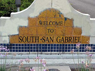
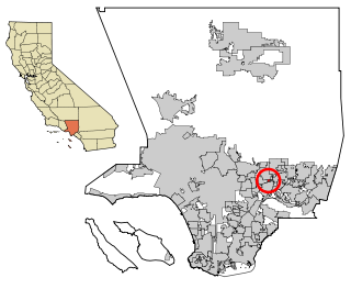
South San Gabriel is a census-designated place (CDP) in Los Angeles County, California, United States. The population was 8,070 at the 2010 census, up from 7,595 at the 2000 census.

<span class="mw-page-title-main">Boronda, California</span> Census-designated place in California, United States

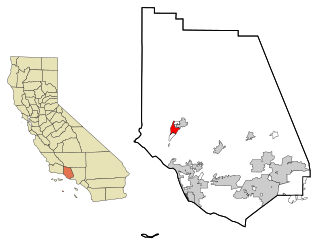
Boronda is an unincorporated community and census-designated place (CDP) in Monterey County, California, United States. The population was 1,760 at the 2020 census. Boronda is located directly west of Salinas and is named after José Eusebio Boronda, a Californio ranchero, and located on the lands of his Rancho Rincón del Sanjón.

<span class="mw-page-title-main">Chino, California</span> City in California, United States

Chino is a city in the western end of San Bernardino County, California, United States, with Los Angeles County to its west and Orange County to its south in the Southern California region.

<span class="mw-page-title-main">Lakeside, California</span> Census designated place in California, United States

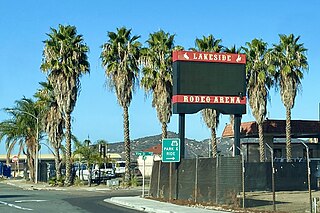
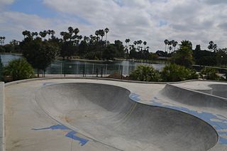
Lakeside is a census-designated place (CDP) in the East County region of San Diego County, California. The population was 21,152 at the 2020 census, up from 20,648 as of the 2010 census.

<span class="mw-page-title-main">Buellton, California</span> City in California, United States

Buellton is a small city in Santa Barbara County, California, United States. It is located in the Santa Ynez Valley, 3 miles (4.8 km) west of Solvang. The population was 5,161 at the 2020 census, up from 4,828 at the 2010 census.

<span class="mw-page-title-main">Monte Sereno, California</span> City in California, United States

Monte Sereno is a city in Santa Clara County, California, United States. The population was 3,479 at the 2020 census. The city is located in the foothills of the Santa Cruz Mountains, about 10 miles (16 km) southwest of San Jose, and is bordered by the town of Los Gatos to the north, east, and south, the Santa Cruz Mountains to the southwest, and the city of Saratoga to the northwest. The city is named for the 2,580-foot (790 m) El Sereno Mountain, upon the slopes of which the southern portion of the city is built. The community is entirely residential with no commercial zoning and 99% single-family housing. It is an upscale Silicon Valley commuter town. Monte Sereno shares the 95030 ZIP code with the town of Los Gatos. Many municipal services are provided under contract by Los Gatos.

<span class="mw-page-title-main">Mira Monte, California</span> Rural community in Ventura County, California, United States

Mira Monte is a rural community in Ventura County, California, United States. Mira Monte is located in between the communities of Oak View, Meiners Oaks, and southwest of the City of Ojai, California. For statistical purposes, the United States Census Bureau has defined Mira Monte as a census-designated place (CDP). The census definition of the area may not precisely correspond to local understanding of the area with the same name. According to the 2020 census, the population of Mira Monte is 6,618, down from 6,845 at the 2010 census.

<span class="mw-page-title-main">Ammon, Idaho</span> City in Idaho, United States

Ammon is a suburb city in Bonneville County, Idaho, United States. As of the 2010 US Census, the population of Ammon was 13,816. By the 2020 census, Ammon's population had grown to 17,694. It lies directly to the east of Idaho Falls and to the west of the Ammon foothills, and is the second most populous city in the Idaho Falls metropolitan area.

<span class="mw-page-title-main">El Paso, Illinois</span> City in Illinois, United States

El Paso is a city in Woodford and McLean counties in the U.S. state of Illinois. The population was 2,756 at the 2020 census. The Woodford County portion of El Paso is part of the Peoria Metropolitan Statistical Area.

<span class="mw-page-title-main">Del Monte Forest, California</span> Census-designated place in California, United States

Del Monte Forest is a census-designated place (CDP) in Monterey County, California, United States. As of the 2020 census, the CDP had a total population of 4,204, down from 4,514 at the 2010 census. The census area includes the separate well-known community of Pebble Beach.

<span class="mw-page-title-main">Maple Heights, Ohio</span> City in Ohio, United States

Maple Heights is a city in Cuyahoga County, Ohio, United States. It is a suburb of Cleveland. The population was 23,701 at the 2020 census.

<span class="mw-page-title-main">Lennox, South Dakota</span> City in South Dakota, United States

Lennox is a city in Lincoln County, South Dakota, United States, located 20 miles (32 km) southwest of Sioux Falls. The population was 2,423 at the 2020 census.

<span class="mw-page-title-main">Garretson, South Dakota</span> City in South Dakota, United States

Garretson is a city in Minnehaha County, South Dakota, United States. The city had a population of 1,228 at the 2020 census.

<span class="mw-page-title-main">Sisseton, South Dakota</span> City in South Dakota, United States

Sisseton is a city in Roberts County, South Dakota, United States. The population was 2,479 at the 2020 census. It is the county seat of Roberts County. Sisseton is the home to a number of tourist attractions, including the Nicollet Tower, and is near the "Song to the Great Spirit" building on the Sisseton Wahpeton College campus. The city is named for the Sisseton division of the Native American Sioux. It also serves as an important part of the Lake Traverse Indian Reservation.

<span class="mw-page-title-main">Alamo Heights, Texas</span> City in Texas, United States

Alamo Heights is an incorporated city that is surrounded by the city of San Antonio in Bexar County in the U.S. state of Texas. At the time of the 2020 census, the population of Alamo Heights was 7,357. It is part of the Greater San Antonio metropolitan area. A portion of the University of the Incarnate Word is in Alamo Heights.

References

  1. "California Cities by Incorporation Date". California Association of Local Agency Formation Commissions. Archived from the original (Word) on October 17, 2013. Retrieved August 25, 2014.
  2. 1 2 3 4 "City Departments & Services: City Council". City of South El Monte. Retrieved December 30, 2014.
  3. "2019 U.S. Gazetteer Files". United States Census Bureau. Retrieved July 1, 2020.
  4. "South El Monte". Geographic Names Information System . United States Geological Survey, United States Department of the Interior . Retrieved February 23, 2015.
  5. 1 2 "Population and Housing Unit Estimates". United States Census Bureau. May 24, 2020. Retrieved May 27, 2020.
  6. "USPS - ZIP Code Lookup - Find a ZIP+ 4 Code By City Results". Archived from the original on February 7, 2012. Retrieved January 18, 2007.
  7. "Number Administration System - NPA and City/Town Search Results". Archived from the original on September 29, 2007. Retrieved January 18, 2007.
  8. "Census of Population and Housing". Census.gov. Retrieved June 4, 2015.
  9. 1 2 "South el Monte (City) QuickFacts from the US Census Bureau". Archived from the original on November 6, 2013. Retrieved November 30, 2013.
  10. "2010 Census Interactive Population Search: CA - South El Monte city". U.S. Census Bureau. Archived from the original on July 15, 2014. Retrieved July 12, 2014.
  11. "U.S. Census website". United States Census Bureau . Retrieved January 31, 2008.
  12. "サンゲーブル校 Archived 2014-03-30 at the Wayback Machine ." Asahi Gakuen. Retrieved on March 30, 2014. "所在地: South El Monte High Ashool 1001 N. Durfee Ave., South El Monte, CA 91733 "
  13. "Final Maps". We Draw the Lines CA. Archived from the original on December 7, 2022. Retrieved January 23, 2023.
  14. "California's 31st Congressional District - Representatives & District Map". Civic Impulse, LLC.
  15. "Temple Station Archived 2010-01-30 at the Wayback Machine ." Los Angeles County Sheriff's Department. Retrieved on January 21, 2010.