Aliso Viejo is a city in the San Joaquin Hills of southern Orange County, California. It had a population of 52,176 as of the 2020 census, up from 47,823 as of the 2010 census. It became Orange County's 34th city on July 1, 2001, the only city in Orange County to be incorporated since 2000. It is bordered by the cities of Laguna Beach on the west and southwest, Laguna Hills on the east, Laguna Niguel on the southeast, and Laguna Woods on the north. It is similarly named to another nearby city, Mission Viejo.
Coto de Caza is a census-designated place (CDP) and guard-gated private community in Orange County, California, United States. The population was 14,710 at the 2020 census.

Portola Hills is a district in the city of Lake Forest, California in Orange County, United States. It was formerly an unincorporated community and census-designated place before it was annexed into Lake Forest in 2000. The population was 6,391 at the 2000 census. Portola Hills lies near Whiting Ranch Wilderness Park and Cleveland National Forest. Foothill Ranch is to the west, Rancho Santa Margarita in the southeast, Mission Viejo in the south, and the unincorporated regions of Silverado and Santiago Canyon to the north and northeast.

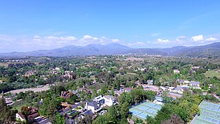
Rancho Santa Margarita is a city in Orange County, California, United States. One of Orange County's youngest cities, Rancho Santa Margarita is a master-planned community. The population was 47,853 at the 2010 census, up from 47,214 at the 2000 census. Although it is named for Rancho Santa Margarita y Las Flores, which was in San Diego County, the city limits fall within the borders of Rancho Mission Viejo. At 20 characters long, it is the longest city name in California.

Wrightwood is a census-designated place in San Bernardino County, California. It sits at an elevation of 6,000 feet (1,800 m). The population was 4,525 at the 2010 census, up from the population of 3,837 at the 2000 census. Wrightwood is located 77 miles (124 km) northeast of Los Angeles. Wrightwood is on the Pacific Crest Trail.
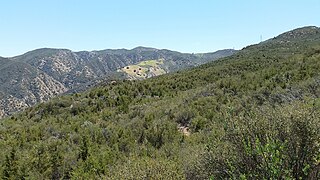
The Santa Ana Mountains are a short peninsular mountain range along the coast of Southern California in the United States. They extend for approximately 61 miles (98 km) southeast of the Los Angeles Basin largely along the border between Orange and Riverside counties.

Trabuco Canyon is a small unincorporated community located in the foothills of the Santa Ana Mountains in eastern Orange County, California, and lies partly within the Cleveland National Forest.
Silverado is an unincorporated community in Silverado Canyon, which is located in the Santa Ana Mountains in eastern Orange County, California. Portions of the town sit on a former Mexican land grant Rancho Lomas de Santiago. Silverado is located at the boundaries of Cleveland National Forest. The site is a California Historical Landmark, and is located near the village site of Puhú.

Theodore Payne, was an English horticulturist, gardener, landscape designer, and botanist. His best known work was done over his adult life in Southern California.

The Silverado Resort and Spa is a 1,200-acre (4.9 km2) golf, tennis, and spa resort in Napa County, California, United States. The venue is named after the Silverado Mine, a quicksilver mine near Mount Saint Helena. The resort is the fifth largest employer in Napa County.
Santiago Canyon is a canyon and unincorporated community in South Orange County, California. According to the 2000 census, Santiago Canyon has several hundred residents living within its borders. Trabuco Canyon, Silverado Canyon, Modjeska Canyon and Williams Canyon are tributaries of Santiago Canyon. Santiago Creek flows northwest from the canyon, then west into the Santa Ana River. Neighborhoods in Santiago Canyon include Santiago Canyon Estates and Falcon View Estates. The landmark Cook's Corner motorcycle restaurant is also located within Santiago Canyon.

The Santiago Fire was a wildfire located near Santiago Canyon in Orange County, California, U.S., and one of thirty California wildfires of October 2007. The fire was intentionally started.
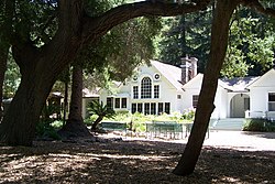
Tucker Wildlife Sanctuary is a non-profit nature reserve on the Santa Ana Mountains in Orange County, California, in the United States. It is located near the end of Modjeska Canyon, at the foot of Modjeska Peak, and adjacent to the Cleveland National Forest. The Sanctuary is owned and operated by the Environmental Nature Center (ENC). The nearest community is the city of Lake Forest.

Santiago Creek is a major watercourse in Orange County in the U.S. state of California. About 34 miles (55 km) long, it drains most of the northern Santa Ana Mountains and is a tributary to the Santa Ana River. It is one of the longest watercourses entirely within the county. The creek shares its name with Santiago Peak, at 5,687 ft (1,733 m) the highest point in Orange County, on whose slopes its headwaters rise.

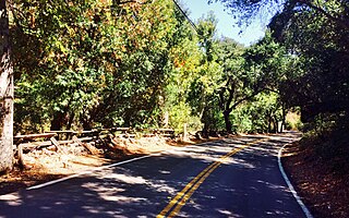
Silverado Canyon is a roughly 2,500-foot-deep gorge in the Santa Ana Mountains, in the U.S. state of California. The small stream it is associated with, Silverado Creek, rises on the north slope of Modjeska Peak at the elevation of 3,980 feet (1,210 m) and flows north and west, past the town of Silverado to join Santiago Creek at 942 feet (287 m) after a journey of just under 5 miles (8.0 km). The main branch, Ladd Canyon, is just over 3 miles (4.8 km) long. Its stream arises on the east flank of Pleasants Peak at about 3,590 feet (1,090 m) and flows southwest into the main stem at about 1,178 feet (359 m) near Silverado. They are part of the Santa Ana River watershed. A hiking trail/fire road runs the entire length of the canyon.

The Sand Fire was a wildfire in 2016 that burned in the Angeles National Forest, east of the Santa Clarita Valley in Los Angeles County, California. The fire, named for the area's Sand Canyon, was fueled by heavy chaparral and brush.
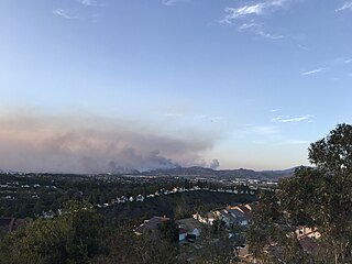
The Silverado Fire was a wildfire that burned in October and November 2020 in southern Orange County, California northeast of Irvine. The fire started on October 26 around 6:47 AM near Orange County Route S-18 and Silverado Canyon Road, fueled by strong Santa Ana winds gusting up to 80 miles per hour (130 km/h) and low humidity. Orange County Fire Authority Chief Brian Fennessy stated, "The winds were extraordinary even by Santa Ana standards. Fire spread is exceeding more than anything I've seen in my 44 years." The fire initially moved south from Loma Ridge toward the Orchard Hills, Northwood and Portola Springs communities of Irvine before moving southeast through Limestone Canyon and toward the communities of Foothill Ranch and Lake Forest. The fire burned in a path similar to that taken by the 2007 Santiago Fire, mostly through terrain that had not seen significant burning in the 13 years since that fire. 100% containment was announced on November 7, 2020.

The Bond Fire was a wildfire that burned 6,686 acres (2,706 ha) in the Santiago Canyon area of Orange County, California in December 2020. The fire caused evacuations of 25,000 residents and injured 2 firefighters. The fire was very close to the burn scar of the Silverado Fire, which took place in October 2020.

Whiting Ranch Wilderness Park is a public regional park in southern Orange County, California. Whiting Ranch features riparian, oak woodland, grassland, chaparral, and coastal sage scrub environments throughout various canyons and hillscapes. The 2,500-acre park mostly encompasses unincorporated land just outside of Lake Forest. The park is home to over 17 miles of trail spread out over 23 different paths, making the location a popular destination for mountain bikers, hikers, and horseback riders.
Williams Canyon is an unincorporated community and census-designated place (CDP) in the canyon of the same name in Orange County, California, United States. It is located in eastern Orange County on the western side of the Santa Ana Mountains, south of Silverado and north of Modjeska. Most of the community is within Cleveland National Forest.