Related Research Articles

Hudson Bay, sometimes called Hudson's Bay, is a large body of saltwater in northeastern Canada with a surface area of 1,230,000 km2 (470,000 sq mi). It is located north of Ontario, west of Quebec, northeast of Manitoba and southeast of Nunavut, but politically entirely part of Nunavut. It is an inland marginal sea of the Arctic Ocean. It drains a very large area, about 3,861,400 km2 (1,490,900 sq mi), that includes parts of southeastern Nunavut, Alberta, Saskatchewan, Ontario, Quebec, all of Manitoba, and parts of the U.S. states of North Dakota, South Dakota, Minnesota, and Montana. Hudson Bay's southern arm is called James Bay.

Lake Agassiz was a large proglacial lake that existed in central North America during late Pleistocene, fed by meltwater from the retreating Laurentide Ice Sheet at the end of the last glacial period. At its peak, the lake's area was larger than all of the modern Great Lakes combined.

The Wisconsin Glacial Episode, also called the Wisconsin glaciation, was the most recent glacial period of the North American ice sheet complex. This advance included the Cordilleran Ice Sheet, which nucleated in the northern North American Cordillera; the Innuitian ice sheet, which extended across the Canadian Arctic Archipelago; the Greenland ice sheet; and the massive Laurentide Ice Sheet, which covered the high latitudes of central and eastern North America. This advance was synchronous with global glaciation during the last glacial period, including the North American alpine glacier advance, known as the Pinedale glaciation. The Wisconsin glaciation extended from approximately 75,000 to 11,000 years ago, between the Sangamonian Stage and the current interglacial, the Holocene. The maximum ice extent occurred approximately 25,000–21,000 years ago during the last glacial maximum, also known as the Late Wisconsin in North America.

The Last Glacial Period (LGP), also known colloquially as the Last Ice Age or simply Ice Age, occurred from the end of the Eemian to the end of the Younger Dryas, encompassing the period c. 115,000 – c. 11,700 years ago.

Post-glacial rebound is the rise of land masses after the removal of the huge weight of ice sheets during the last glacial period, which had caused isostatic depression. Post-glacial rebound and isostatic depression are phases of glacial isostasy, the deformation of the Earth's crust in response to changes in ice mass distribution. The direct raising effects of post-glacial rebound are readily apparent in parts of Northern Eurasia, Northern America, Patagonia, and Antarctica. However, through the processes of ocean siphoning and continental levering, the effects of post-glacial rebound on sea level are felt globally far from the locations of current and former ice sheets.

The Ungava Peninsula is the far northwestern part of the Labrador Peninsula of the province of Quebec, Canada. Bounded by Hudson Bay to the west, Hudson Strait to the north, and Ungava Bay to the east, it covers about 252,000 square kilometres (97,000 sq mi). Its northernmost point is Cape Wolstenholme, which is also the northernmost point of Quebec. The peninsula is also part of the Canadian Shield, and consists entirely of treeless tundra dissected by large numbers of rivers and glacial lakes, flowing generally east–west in a parallel fashion. The peninsula was not deglaciated until 6,500 years ago and is believed to have been the prehistoric centre from which the vast Laurentide Ice Sheet spread over most of North America during the last glacial epoch.

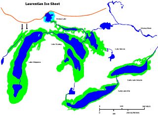
The Laurentide Ice Sheet was a massive sheet of ice that covered millions of square miles, including most of Canada and a large portion of the Northern United States, multiple times during the Quaternary glacial epochs, from 2.58 million years ago to the present.

The Cordilleran ice sheet was a major ice sheet that periodically covered large parts of North America during glacial periods over the last ~2.6 million years.

Lake Duluth was a proglacial lake that formed in the Lake Superior drainage basin as the Laurentide Ice Sheet retreated. The oldest existing shorelines were formed after retreat from the Greatlakean advance, sometime around 11,000 years B.P. Lake Duluth formed at the western end of the Lake Superior basin. Lake Duluth overflowed south through outlets in Minnesota and Wisconsin at an elevation of around 331 m above sea level.
Early Lake Erie was a prehistoric proglacial lake that existed at the end of the last ice age approximately 13,000 years ago. The early Erie fed waters to Glacial Lake Iroquois.
The Holocene glacial retreat is a geographical phenomenon that involved the global retreat of glaciers (deglaciation) that previously had advanced during the Last Glacial Maximum. Ice sheet retreat initiated ca. 19,000 years ago and accelerated after ca. 15,000 years ago. The Holocene, starting with abrupt warming 11,700 years ago, resulted in rapid melting of the remaining ice sheets of North America and Europe.

Lake Ojibway was a prehistoric lake in what is now northern Ontario and Quebec in Canada. Ojibway was the last of the great proglacial lakes of the last ice age. Comparable in size to Lake Agassiz, and north of the Great Lakes, it was at its greatest extent c. 8,500 years BP. The former lakebed forms the modern Clay Belt, an area of fertile land.
Glacial Lake Connecticut formed over what is now Long Island Sound and coastal Connecticut at the fore edge of the ice sheet of the Wisconsin glaciation, as the lobe of the Laurentide Ice Sheet began to retreat, some 18 to 20,000 years before present. It was dammed by the terminal moraine that now forms the spine of Long Island and Fishers Island. About 15,000 BP, the moraine dam that impounded Lake Connecticut failed; the outlet, known as The Race for its tidal rip currents, lies between the North Fork of Long Island and Fishers Island. For a time, much of the lake bed was exposed to wind-driven erosion: the cue is found in soundings that reveal regional unconformities in the sediment bed of Long Island Sound.

The glacial history of Minnesota is most defined since the onset of the last glacial period, which ended some 10,000 years ago. Within the last million years, most of the Midwestern United States and much of Canada were covered at one time or another with an ice sheet. This continental glacier had a profound effect on the surface features of the area over which it moved. Vast quantities of rock and soil were scraped from the glacial centers to its margins by slowly moving ice and redeposited as drift or till. Much of this drift was dumped into old preglacial river valleys, while some of it was heaped into belts of hills at the margin of the glacier. The chief result of glaciation has been the modification of the preglacial topography by the deposition of drift over the countryside. However, continental glaciers possess great power of erosion and may actually modify the preglacial land surface by scouring and abrading rather than by the deposition of the drift.
Glacial River Warren, also known as River Warren, was a prehistoric river that drained Lake Agassiz in central North America between about 13,500 and 10,650 BP calibrated years ago. A part of the uppermost portion of the former river channel was designated a National Natural Landmark in 1966.

The Weichselian glaciation was the last glacial period and its associated glaciation in northern parts of Europe. In the Alpine region it corresponds to the Würm glaciation. It was characterized by a large ice sheet that spread out from the Scandinavian Mountains and extended as far as the east coast of Schleswig-Holstein, northern Poland and Northwest Russia. This glaciation is also known as the Weichselian ice age, Vistulian glaciation, Weichsel or, less commonly, the Weichsel glaciation, Weichselian cold period (Weichsel-Kaltzeit), Weichselian glacial (Weichsel-Glazial), Weichselian Stage or, rarely, the Weichselian complex (Weichsel-Komplex).
Deglaciation is the transition from full glacial conditions during ice ages, to warm interglacials, characterized by global warming and sea level rise due to change in continental ice volume. Thus, it refers to the retreat of a glacier, an ice sheet or frozen surface layer, and the resulting exposure of the Earth's surface. The decline of the cryosphere due to ablation can occur on any scale from global to localized to a particular glacier. After the Last Glacial Maximum, the last deglaciation begun, which lasted until the early Holocene. Around much of Earth, deglaciation during the last 100 years has been accelerating as a result of climate change, partly brought on by anthropogenic changes to greenhouse gases.

The Goldthwait Sea was a sea that emerged during the last deglaciation, starting around 13,000 years ago, covering what is now the Gulf of Saint Lawrence and surrounding areas. At that time, the land had been depressed under the weight of the Laurentide Ice Sheet, which was up to 2 kilometres (1.2 mi) thick. Areas on the Anticosti Island and low-lying regions of Quebec and the Maritimes bordering the Saint Lawrence were below sea level. As the land rebounded over the next 3,000 years, despite rising sea levels the sea retreated to roughly the present boundaries of the Gulf.
The Keewatin ice sheet was a major ice sheet that periodically covered large parts of North America during glacial periods over the last ~2.6 million years. This included the following areas:
The Labrador ice sheet was a major ice sheet that periodically covered large parts of North America during glacial periods over the last ~2.6 million years. The seam between the two ice sheets passed over the northern tip of the Ugava Peninsula passing south across Hudson Bay and on to the Ontario shore near Fort Stevens. This seam continued southward across Lake Superior, east of the Keweenaw Peninsula of Michigan. Southward into Wisconsin, along the Lake Michigan shoreline, crossing into western Illinois. Reaching down the Mississippi River valley to its junction with the Missouri River, it reaches its most southern point. At this point, the ice sheet no longer abuts the Keewatin ice sheet.
References
- 1 2 3 Lajeuness, Patrick; Allard, Michael (2003). "The Nastapoka drift belt, eastern Hudson Bay: implications of a stillstand of the Quebec-Labrador ice margin in the Tyrrell Sea at 8 ka BP" (PDF). Canadian Journal of Earth Sciences. 40 (1): 65–76. Bibcode:2003CaJES..40...65L. doi:10.1139/e02-085. Archived from the original (PDF) on 2004-03-22.
- 1 2 "Geomorphology From Space, Plate C-24: Hudson Bay Shorelines." (Accessed 3/7/06)
- 1 2 Pielou, E. C. (1991). After the Ice Age . Chicago: University of Chicago Press. pp. 222–224. ISBN 0-226-66811-8.
| Africa | |||||||||||||||||||||||||||||
|---|---|---|---|---|---|---|---|---|---|---|---|---|---|---|---|---|---|---|---|---|---|---|---|---|---|---|---|---|---|
| Antarctica | |||||||||||||||||||||||||||||
| Asia | |||||||||||||||||||||||||||||
| Europe |
| ||||||||||||||||||||||||||||
| North America |
| ||||||||||||||||||||||||||||
| South America | |||||||||||||||||||||||||||||
| Summary | |||||||||||||||||||||||||||||
| | This palaeogeography article is a stub. You can help Wikipedia by expanding it. |