
Lake Ontario is one of the five Great Lakes of North America. It is bounded on the north, west, and southwest by the Canadian province of Ontario, and on the south and east by the U.S. state of New York. The Canada–United States border spans the centre of the lake.

Lake Agassiz was a large proglacial lake that existed in central North America during the late Pleistocene, fed by meltwater from the retreating Laurentide Ice Sheet at the end of the last glacial period. At its peak, the lake's area was larger than all of the modern Great Lakes combined.

The Wisconsin Glacial Episode, also called the Wisconsin glaciation, was the most recent glacial period of the North American ice sheet complex, peaking more than 20,000 years ago. This advance included the Cordilleran Ice Sheet, which nucleated in the northern North American Cordillera; the Innuitian ice sheet, which extended across the Canadian Arctic Archipelago; the Greenland ice sheet; and the massive Laurentide Ice Sheet, which covered the high latitudes of central and eastern North America. This advance was synchronous with global glaciation during the last glacial period, including the North American alpine glacier advance, known as the Pinedale glaciation. The Wisconsin glaciation extended from approximately 75,000 to 11,000 years ago, between the Sangamonian Stage and the current interglacial, the Holocene. The maximum ice extent occurred approximately 25,000–21,000 years ago during the last glacial maximum, also known as the Late Wisconsin in North America.

Glacial Lake Wisconsin was a prehistoric proglacial lake that existed from approximately 18,000 to 14,000 years ago, at the end of the last ice age, in the central part of present-day Wisconsin in the United States.

Lake Tonawanda was a prehistoric lake that existed approximately 10,000 years ago at the end of the last ice age, in Western New York, United States.

The Southern Laurentian Channel is an ancient underground river in southern Ontario, Canada. The river predates the recent ice ages. The river valley was filled with glacial debris. Water still flows down this old valley—underground. The source of the aquifer is the Georgian Bay, approximately 200 kilometres (120 mi) away.

The Scarborough Bluffs, also known as The Bluffs, is an escarpment in the Scarborough district of Toronto, Ontario, Canada. There are nine parks along the bluffs, with Bluffers Park being the only one with a beach. Forming much of the eastern portion of Toronto's waterfront, the Scarborough Bluffs stands above the shoreline of Lake Ontario. At its highest point, the escarpment rises 90 metres (300 ft) above the coastline and spans a length of 15 kilometres (9.3 mi).
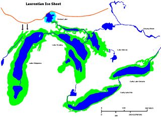
Early Lake Erie was a prehistoric proglacial lake that existed at the end of the last ice age approximately 13,000 years ago. The early Erie fed waters to Glacial Lake Iroquois.

Lake Chicago was a prehistoric proglacial lake that is the ancestor of what is now known as Lake Michigan, one of North America's five Great Lakes. Formed about 13,000 years ago and fed by retreating glaciers, it drained south through the Chicago Outlet River.

The geography of Toronto, Ontario, covers an area of 630 km2 (240 sq mi) and is bounded by Lake Ontario to the south; Etobicoke Creek, Eglinton Avenue, and Highway 427 to the west; Steeles Avenue to the north; and the Rouge River and the Scarborough–Pickering Townline to the east. In addition to Etobicoke Creek and the Rouge River, the city is trisected by two minor rivers and their tributaries, the Humber River in the west end and the Don River east of downtown. Both flow southward to Lake Ontario at Humber Bay and Toronto Harbour respectively, which are part of the longer Waterfront, as well as Etobicoke Creek and the Rouge River.

The Kankakee Outwash Plain is a flat plain interspersed with sand dunes in the Kankakee River valley in northwestern Indiana and northeastern Illinois of the United States. It is just south of the Valparaiso Moraine and was formed during the Wisconsin Glaciation. As the glacier stopped at the Valparaiso Moraine, its meltwater was carried away to the outwash plain. On the south side of the moraine, where the elevation drops, the meltwaters eroded away valleys, carrying sand and mud with them. As the muddy meltwater reached the valley where the slope lessened, the water slowed, depositing the sand on the outwash plain. This created a smooth, flat, and sandy plain. Before its draining, the Kankakee Marsh, located on the outwash plain, was one of the largest freshwater marshes in the United States.
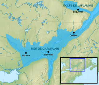
The Champlain Sea was a prehistoric inlet of the Atlantic Ocean into the North American continent, created by the retreating ice sheets during the closure of the last glacial period. The inlet once included lands in what are now the Canadian provinces of Quebec and Ontario, as well as parts of the American states of New York and Vermont. Today, the remains of the sea include the St. Lawrence Seaway, Lake Champlain, Lake of Two Mountains on the lower Ottawa River, the lower Saguenay River, as well as other lakes, islands and shores.

Mississauga is a city in the Canadian province of Ontario. It is a suburb of Toronto. The city is situated in the Regional Municipality of Peel and covers 288.42 square kilometres (111.36 sq mi) of land, fronting 13 kilometres (8.1 mi) of shoreline on Lake Ontario.

Lake Kankakee formed 14,000 years before present (YBP) in the valley of the Kankakee River. It developed from the outwash of the Michigan Lobe, Saginaw Lobe, and the Huron-Erie Lobe of the Wisconsin glaciation. These three ice sheets formed a basin across Northwestern Indiana. It was a time when the glaciers were receding, but had stopped for a thousand years in these locations. The lake drained about 13,000 YBP, until reaching the level of the Momence Ledge. The outcropping of limestone created an artificial base level, holding water throughout the upper basin, creating the Grand Kankakee Marsh.
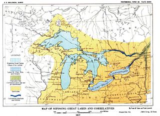
Nipissing Great Lakes was a prehistoric proglacial lake. Parts of the former lake are now Lake Superior, Lake Huron, Georgian Bay and Lake Michigan. It formed about 7,500 years before present (YBP). The lake occupied the depression left by the Labradorian Glacier. This body of water drained eastward from Georgian Bay to the Ottawa valley. This was a period of isostatic rebound raising the outlet over time, until it opened the outlet through the St. Clair valley, at one stage it had two stable outlets both draining to the east.

The Marseilles moraine is a terminal moraine that encircles the southern tip of Lake Michigan in North America. It begins near Elgin, Illinois, and extends south and west of Chicago metropolitan area, turning eastward 30 miles (48 km) to 40 miles (64 km) south of the lake in Kankakee and Iroqouis counties, entering Indiana. It formed during the Wisconsin glaciation. The glacier had been in retreat when it stopped for an extended period, depositing glacial till and sand creating the hills of the moraine.
Lake Arkona was a stage of the lake waters in the Huron-Erie-Ontario basin following the end of the Lake Maumee levels and before the Lake Whittlesey stages, named for Arkona, Ontario, about 50 miles (80 km) east of Sarnia.

Lake Warren was a proglacial lake that formed in the Lake Erie basin around 12,700 years before present (YBP) when Lake Whittlesey dropped in elevation. Lake Warren is divided into three stages: Warren I 690 feet (210 m), Warren II 680 feet (210 m), and Warren III 675 feet (206 m), each defined by the relative elevation above sea level.

The Erie Plain is a lacustrine plain that borders Lake Erie in North America. From Buffalo, New York, to Cleveland, Ohio, it is quite narrow, but broadens considerably from Cleveland around Lake Erie to Southern Ontario, where it forms most of the Ontario peninsula. The Erie Plain was used in the United States as a natural gateway to the North American interior, and in both the United States and Canada the plain is heavily populated and provides very fertile agricultural land.


