
The Great Lakes also called the Great Lakes of North America or the Laurentian Great Lakes, is a series of large interconnected freshwater lakes in the mid-east region of North America that connect to the Atlantic Ocean via the Saint Lawrence River. They are Lakes Superior, Michigan, Huron, Erie, and Ontario and are in general on or near the Canada–United States border. Hydrologically, there are four lakes, because lakes Michigan and Huron join at the Straits of Mackinac. The Great Lakes Waterway enables travel by water among the lakes.

Lake Ontario is one of the five Great Lakes of North America. It is surrounded on the north, west, and southwest by the Canadian province of Ontario, and on the south and east by the U.S. state of New York, whose water boundaries meet in the middle of the lake.

Lake Michigan is one of the five Great Lakes of North America. It is the second-largest of the Great Lakes by volume and the third-largest by surface area, after Lake Superior and Lake Huron. To the east, its basin is conjoined with that of Lake Huron through the narrow Straits of Mackinac, giving it the same surface elevation as its easterly counterpart; the two are technically a single lake.

Lake Superior is the largest and northernmost of the Great Lakes of North America, and among freshwater lakes, it is the world's largest by surface area and the third-largest by volume. It holds 10% of the world's surface fresh water. It is shared by Ontario, Canada, to the north, and states in the United States in other directions: Minnesota to the west, and Wisconsin and the Upper Peninsula of Michigan to the south. Lake Superior is the most northerly and most westerly of the Great Lakes chain, and the highest in elevation. It drains into Lake Huron via St. Mary's River.

Lake Huron is one of the five Great Lakes of North America. Hydrologically, it comprises the easterly portion of Lake Michigan–Huron, having the same surface elevation as its westerly counterpart, to which it is connected by the 5-mile-wide (8.0 km), 20-fathom-deep Straits of Mackinac. It is shared on the north and east by the Canadian province of Ontario and on the south and west by the U.S. state of Michigan. The name of the lake is derived from early French explorers who named it for the Huron people inhabiting the region. The Huronian glaciation was named from evidence collected from Lake Huron region. The northern parts of the lake include the North Channel and Georgian Bay. Saginaw Bay is located in the southwest corner of the lake. The main inlet is the St. Marys River, and the main outlet is the St. Clair River.

Chippewa County is a county in the Upper Peninsula of the U.S. state of Michigan. As of the 2020 Census, the population was 36,785. The county seat is Sault Ste. Marie. The county is named for the Ojibwe (Chippewa) people, and was set off and organized in 1826.

Drummond Island Township is a civil township of Chippewa County in the U.S. state of Michigan. The population was 1,058 at the 2010 census.

Lake Simcoe is a lake in southern Ontario, Canada, the fourth-largest lake wholly in the province, after Lake Nipigon, Lac Seul, and Lake Nipissing. At the time of the first European contact in the 17th century the lake was called Ouentironk by the Wyandot (Huron) people. It was also known as Lake Taronto until it was renamed by John Graves Simcoe, the first Lieutenant-Governor of Upper Canada, in memory of his father, Captain John Simcoe, Royal Navy.
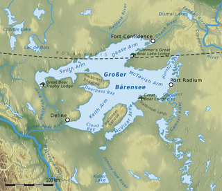
Great Bear Lake is a lake in the boreal forest of Canada. It is the largest lake entirely in Canada, the fourth-largest in North America, and the eighth-largest in the world by surface area. The lake is in the Northwest Territories, on the Arctic Circle between 65 and 67 degrees of northern latitude and between 118 and 123 degrees western longitude, 156 m (512 ft) above sea level.

The Black Sturgeon River is a river in Thunder Bay District, Northwestern Ontario, Canada, located west of the Nipigon River, that flows to Lake Superior.

Lac Vieux Desert is a lake in the United States divided between Gogebic County, Michigan, and Vilas County, Wisconsin. Fed primarily by springs in the surrounding swamps, it is the source of the Wisconsin River, which flows out of its southwest corner. The lake contains a number of small islands, especially in its northeastern lobe, including Draper Island in Michigan and Duck Island, in Wisconsin.

Batchawana Bay is a small bay in Algoma District in Northeastern Ontario, Canada. It is on the eastern shore of Lake Superior, approximately 50 kilometres (31 mi) north of Sault Ste. Marie.
The Temagami River, formerly spelled as Timagami River, is a river in the Nipissing District of Ontario, Canada, in the Temagami region. Its source is Lake Temagami and flows through Cross Lake and Red Cedar Lake. It flows into the Sturgeon River at the community of River Valley.

The Cabonga Reservoir is a man-made lake in central Quebec, Canada, with a total surface area of 677 square kilometres (261 sq mi) and a net area of 484 square kilometres (187 sq mi). It is located on the boundary between the unorganized territories of Lac-Pythonga and Réservoir-Dozois, and fully within the La Vérendrye Wildlife Reserve. The First Nations reserve of Rapide Lake is on its western shores.
Manistique Lake, locally called Big Manistique Lake to distinguish it from the other lakes in the Manistique Lakes system, is a 10,130-acre (4,100 ha) lake in the Upper Peninsula of the U.S. state of Michigan. Approximately 6.5 miles (10.5 km) long and 4 miles (6.4 km) wide, it is one of the largest lakes in the Upper Peninsula. Elevated 686 feet (209 m) above sea level and 105 feet (32 m) above Lake Michigan, Manistique Lake drains into the larger lake through a marshy outlet on the west end of the lake that forms one source of the Manistique River. Relatively shallow, the lake's deepest point is only 20 feet (6.1 m) below the water surface. The average depth is 10 feet (3.0 m).
The Potagannissing River is an 11.3-mile-long (18.2 km) river in Michigan, located on Drummond Island in Lake Huron.

The Harbor Island National Wildlife Refuge is a 695-acre (281 ha) horseshoe-shaped island and National Wildlife Refuge in Potagannissing Bay north of Drummond Island in the U.S. state of Michigan. The island was acquired in 1983 by the United States Fish and Wildlife Service from its previous owner, the Nature Conservancy, and set aside as a refuge. It is located in Drummond Township, in Chippewa County.
Lake George is a lake in Chippewa County, Michigan, United States, and Algoma District, Northwestern Ontario, Canada, that lies between Sugar Island in Michigan on the west and the Ontario mainland on the east.

