Great Lakes Circle Tour

Last updated

Great Lakes Circle Tour.svg

Great Lakes Circle Tour

Route information
Existed1988–present
Location
Country United States
Highway system
  • Indiana State Highway System
  • Minnesota Trunk Highway System
  • Ohio State Highway System

The Great Lakes Circle Tour is a designated scenic road system connecting all of the Great Lakes and the St. Lawrence River. [1] It consists of routes for circumnavigating the lakes, either individually or collectively. It was designated by the Great Lakes Commission in 1988.

Contents

Tours

Great Lakes Circle Tour in northern Michigan Great Lakes Circle Tour on Interstate 75.jpg
Great Lakes Circle Tour in northern Michigan

Lake Superior Circle Tour

Lake Superior Circle Tour.svg

Lake Superior Circle Tour

LocationAround Lake Superior
Length1,280.56 mi (2,060.86 km)
Existed1988–present

The Lake Superior Circle Tour (LSCT) follows state and provincial highways that are nearby the lake to loop around the entirety of Lake Superior. The LSCT follows state highways in the US states of Michigan, Wisconsin, and Minnesota, and provincial highways in the Canadian province of Ontario.

Michigan

In Michigan, the tour runs from the state line at Ironwood to Sault Ste. Marie. In between it follows U.S. Highway 2 (US 2) to Wakefield, M-28 to Bergland and M-64 to Ontonagon. At Ontonagon, the LSCT continues east along M-38 to M-26. It follows M-26 to Houghton and then follows US 41 north to Copper Harbor. There is a loop route along M-203 between Hancock and Calumet. Travelers following the tour need to backtrack down US 41 to Houghton and then follow US 41 back to M-28 in Covington. US 41/M-28 carries the tour to Harvey where M-28 carries it eastward. There is a spur routing along M-77 running north from Seney to Grand Marais. The mainline tour departs from M-28 to loop northward along M-123 through Newberry to Paradise and back to M-28. Then it follows M-28 for a third time until reaching Interstate 75 (I-75) where it follows the freeway north to Sault Ste. Marie. It leaves Michigan on the Sault Ste. Marie International Bridge crossing into Ontario. [2]

Ontario

Once in Ontario, the tour follows city streets through Sault Ste. Marie to Highway 17, the Trans-Canada Highway. It follows Highway 17 north along the mountainous shoreline through a remote region of Ontario. The highway curves to the west 190 miles (300 km) north of Sault Ste. Marie, and hugs the northern shore of the lake to Nipigon. It meets Highway 11, which is concurrent with Highway 17 thereafter. The tour follows the Thunder Bay Expressway through Thunder Bay. At the intersection of the Harbour Expressway, Highway 11/Highway 17 turns west; the tour continues south, now on Highway 61. Forty miles (60 km) south of Thunder Bay, the tour crosses the Pigeon River into Minnesota. [3]

Minnesota

The LSCT follows Minnesota State Highway 61 (MN 61) between the Canada–United States border (near Thunder Bay) and the city of Duluth. In Duluth, the tour route follows I-35 southbound to the US 2 exit to Wisconsin. [4]

Wisconsin

The Lake Superior Circle Tour in northern Wisconsin on Highway 13 Lake Superior Circle Tour Bayfield County Wisconsin.jpg
The Lake Superior Circle Tour in northern Wisconsin on Highway 13

The circle tour crosses into Wisconsin on the Bong Memorial Bridge carrying US 2 between Duluth, Minnesota and Superior, Wisconsin. In Superior, the tour route follows US 2/US 53 to Wisconsin Highway 13 (WIS 13). Near Ashland, the tour route returns to US 2 across Northern Wisconsin to Hurley and the border with Michigan at Ironwood. [4]

Lake Michigan Circle Tour

Lake Michigan Circle Tour.svg

Lake Michigan Circle Tour

Location Lake Michigan
Existed1988–present

The Lake Michigan Circle Tour (LMCT) loops around Lake Michigan following state highways. These highways are usually the closest to the lake. [1] The LMCT follows state highways in the US states of Illinois, Indiana, Michigan and Wisconsin. A special "spur route" follows the SS Badger ferry across the lake between Ludington, Michigan and Manitowoc, Wisconsin.

Illinois

The LMCT follows Illinois Route 137 from the Wisconsin state line south on Sheridan Road and joins Lake Shore Drive (U.S. 41). The route then follows U.S. 41 as U.S. Routes 12 and 20 run concurrent but split quickly. The tour then follows U.S. Route 12 into Indiana.

Indiana

The LMCT follows I-94 and US 12 in Indiana. [5] The Indiana portion of the Lake Michigan Circle Tour is the urban stretch of the lake. It begins on the Illinois line in the City of Hammond. US 12 continues eastward through the 2nd most populous portion of the State of Indiana. The Gary-Hammond PMSA, a portion of the Chicago-Gary-Kenosha, IL-IN-WI Combined Statistical Area (CMSA) [6] which includes all of Lake and Porter Counties. The third county along the shore, LaPorte County is in the South Bend CMSA. The only "rural" area is the ten miles (16 km) across northern Porter County, where route passes through Indiana Dunes National Park.

Starting from Chicago, US 12 enters Hammond, Indiana, before Whiting. Here, US 12, US 20 and US 41 all share Indianapolis Boulevard. Along the lakefront, is Lakefront Park and Wihala Beach County Park. Located here is the Horseshoe Casino. [7] Whiting also provides easy access to Wolf Lake, which is a remnant of the wetlands and lakes that formed along the shores of Lake Michigan creating a massive wetlands on the Illinois and Indiana border.

US 12 turns more southerly as it passes west and south of Indiana Harbor, an industrial complex of mills, refineries, and docks. Entering East Chicago, US 12 turns east onto Columbus Drive, heading through the Indiana Harbor neighborhood of East Chicago. From East Chicago US 12 becomes Industrial Drive in Gary. [7]

The alternate route for the Circle Tour is along I-94, which is joined with I-80 as the Borman Expressway. Entering Hammond the first stop could be the South Shore Welcome Center located on Kennedy Boulevard off the interstate. [8] Hammond developed because of the wetlands and numerous lakes. The area was not considered suitable for farming or development, until the meat packing industry began to thrive in Chicago. With the creation of refrigerated rail cars, a source of ice was needed. The lakes of northern Indiana were seen as a source of that ice and meat packing moved across the line, creating processing plants and ice house. [9]

Gary is on both routes of the Circle Tour. I-80/I-94 and US 12 both enter the city. US 12 is closer to the lake, entering from East Chicago on Industrial Drive. Named appropriately for the industries and the Gary Airport that developed along the lakefront. U.S. Steel's Gary Plant began in 1906, and brought major industries to this area. Located on the southern shore of Lake Michigan, the city offered direct access to the iron fields of northern Michigan and Minnesota and the coal fields of Ohio and West Virginia. [9]

Following Industrial Drive, US 12 heads southeast, crossing under the Indiana Toll Road. At 4th Street, it turns east into downtown Gary. Downtown Gary is the home of the Railcats Minor League Baseball. [7] Continuing east into the Miller community of Gary, and this is the closest the circle tour comes to the Chicago, South Shore and South Bend Railroad, the last interurban in the United States. Lake Street to the north will take motorists to Lake Michigan and over to Marquette Park, the first dune park along the Indiana Shore. Continuing on US 12, which is now called the Dunes Highway, the buildings end and forest and wetlands dominate. At County Line Road are the signs to Indiana Dunes National Park's West Beach facility and the east end of the Miller community. This is also the location for parking for the Marquette Hike/Bike trail. [8]

Crossing County Line Road on US 12 you enter Portage, in Porter County. Portage owes its growth as a bedroom community to the creation of the Port of Indiana complex.

US 12 continues eastward as the Dunes Highway passing quickly through the town of Burns Harbor

Porter bills itself as the gateway to the Indiana Dunes. Its location with both Indiana Dunes State Park and Indiana Dunes National Park support their claim.

The Dunes Highway continues east into the town of Chesterton, which lies mostly south of US 12, US 20 and I-94.

Beverly Shores was a dune development of the Bartlett Family. Today, it is a residential community with remnants of the various development ideas used to lure home buyers into the dunes. Spanish Eclectic train depot and town hall, and the Old North Church with the Century of Progress Architectural District homes from the 1933 Chicago World's Fair are still present in this diverse architectural community. [7]

Michigan City is just east of Beverly Shores after US 12/Dunes Highway has passed through the Town of the Pines, turned northward along County Line Road. As the Dunes Highway turns east into the Laporte County and the Michigan City limits, you come to the east end of Indiana Dunes National Park at Mount Baldy. The road continues as northeast toward Michigan leaving Indiana at Michiana Shores.

Michigan

The Lake Michigan Circle Tour on the Grandview Parkway in Traverse City, Michigan Grandview Parkway.jpg
The Lake Michigan Circle Tour on the Grandview Parkway in Traverse City, Michigan

The LMCT enters Michigan in Berrien County along US 12. Near New Buffalo the tour switches to follow I-94 north to the Benton Harbor/St. Joseph area. Here the LMCT follows BL I-94 and M-63 back to the freeway, this time the I-196/US 31 freeway. At Holland, the LMCT turns onto BL I-196/US 31. Formerly it also followed BUS US 31 through Holland until that designation was removed. The Circle Tour continues to follow US 31 northward deviating at Muskegon and MontagueWhitehall for the various business loops. [10] At Ludington, the Lake Michigan Circle Tour meets a '"connecting route" over the S.S. Badger carferry. [5] The tour continues to follow US 31 to Manistee where it joins M-22 up and around the Leelanau Peninsula, with a special spur loop following M-109. It rejoins US 31 at Traverse City and follows US 31 to the northern terminus of US 31 south of Mackinaw City. There it runs along I-75 north to the Upper Peninsula of Michigan. The Lake Huron Circle Tour joins I-75 at the northern terminus of US 23 and both run together on I-75 over the Mackinac Bridge. North of the toll plaza in St. Ignace, The LHCT takes Exit 344A to follow BL I-75 while the LMCT takes Exit 344B to follow US 2. [10]

In the Upper Peninsula, the circle tour follows US 2 westward to Rapid River. Here US 41 joins US 2. At Gladstone M-35 joins to form a three-way concurrency south to Escanaba. South of Escanaba, the circle tour follows M-35 to Menominee. Here M-35 ends and US 41 carries the circle tour south into Wisconsin. [10] There is a "spur route" designated along M-183 and Delta County Road 483 on the Garden Peninsula. [5]

Wisconsin

LMCT in southern Wisconsin concurrent with WIS 32 WIS31 WIS32 Lake Michigan Circle Tour.jpg
LMCT in southern Wisconsin concurrent with WIS 32

In Wisconsin, the LMCT follows US 41 south to I-43 in the Green Bay area. From I-43, it runs up into the Door Peninsula along WIS 57 and WIS 42 and back south to I-43. It continues along I-43 to Port Washington where it briefly follows WIS 32 for a few miles through Port Washington then back onto I-43 to Milwaukee where it re-joins WIS 32 to the state border. [5]

Lake Huron Circle Tour

Lake Huron Circle Tour.svg

Lake Huron Circle Tour

Location Lake Huron
Existed1988–present
The Lake Huron Circle Tour near Sault Ste. Marie, Ontario Lake Huron Circle Tour east of Bruce Mines ON.jpg
The Lake Huron Circle Tour near Sault Ste. Marie, Ontario

The Lake Huron Circle Tour (LHCT) progresses clockwise from a starting point at the Blue Water Bridge in Port Huron, Michigan-Sarnia, Ontario. The LHCT continues around Lake Huron, touching on locations including the following:

Michigan

A Michigan spur route utilizes a segment of M-134 to DeTour Village. [11]

Ontario

An Ontario spur route uses the MS Chi-Cheemaun ferry to cross the mouth of Lake Huron's Georgian Bay from the Bruce Peninsula to Manitoulin Island and return. [11]

Lake Erie Circle Tour

Lake Erie Circle Tour.svg

Lake Erie Circle Tour

Location Lake Erie
Length680 mi (1,090 km)
Existed1988–present

The Lake Erie Circle Tour (LECT) loops around Lake Erie following state and provincial highways. These highways are usually the closest to the lake. [1] The LECT follows state highways in the US states of New York, Pennsylvania, Ohio, and Michigan and provincial highways in the Canadian province of Ontario.

Michigan

Starting in Detroit, the LECT follows Interstate 75 (I-75) south from the Ambassador Bridge to exit 43. There it follows M-85 through Lincoln Park to Trenton. At exit 28, the LECT rejoins I-75 and runs south through Monroe to the state line, crossing into Toledo, Ohio. [12]

Ohio

Crossing into the state of Ohio, the LECT leaves I-75 to follow I-280 around the east side of Toledo. The tour then exits I-280 and runs along SR 2 to the city of Sandusky, home of Cedar Point. There it joins U.S. Route 6 (US 6) to Cleveland. West of Cleveland, US 6 merges with US 20 and SR 2 in a three-way concurrency. The LECT will continue to follow SR 2 through downtown Cleveland. On the east side of the city, the tour continues on SR 283 through Euclid to Painesville. There it merges onto US 20 until Geneva. The tour follows SR 531 east along the lake between Geneva and Conneaut, where it returns along US 20 east to the state line.

Pennsylvania

The LECT follows Pennsylvania Route 5 through Erie County. This is also the routing of the Seaway Trail.

New York

Entering New York, the road becomes New York State Route 5 to Buffalo. There it follows the Peace Bridge to Ontario.

Ontario

The LECT follows Ontario Highway 3 through the province, running the entire length from the Peace Bridge to the Ambassador Bridge.

Lake Ontario and Seaway Trail

Seaway Trail

Location OhioPennsylvania state line to Canada–United States border
Length518 mi [13]  (834 km)
Existed1978 [14] –present

Unlike the other four Great Lakes, Lake Ontario is posted not as a circle tour but as part of the US-only Seaway Trail. The trail begins in Erie County, Pennsylvania and travels through Buffalo, Niagara Falls, Rochester, Oswego, and Ogdensburg before ending at the Seaway International Bridge near Massena.

History

Plans for the Great Lakes Circle Tours were started in 1985. The Michigan Department of Transportation (MDOT) was in consultation with its counterparts in Wisconsin (WisDOT), Minnesota (MnDOT) and Ontario (Ministry of Transportation of Ontario, MTO) in May 1986 to establish a tour route around Lake Superior. The project was started by Paula Blanchard, the First Lady of Michigan at the time. She was an adviser to the Michigan Department of Commerce and called for the formation of the tour in the fall of 1985 at a tourism conference. Representatives from the three states and province agreed to the plan. Michigan drafted the first design for the signs in early 1986, sending the design to the other governments for approval. [15] The Great Lakes Commission approved the formation of a Great Lakes Circle Tour in November 1988. [16]

See also

Related Research Articles

<span class="mw-page-title-main">Lake Michigan</span> One of the Great Lakes of North America

Lake Michigan is one of the five Great Lakes of North America. It is the second-largest of the Great Lakes by volume and the third-largest by surface area, after Lake Superior and Lake Huron. To the east, its basin is conjoined with that of Lake Huron through the 3+12-mile (5.6-kilometre) wide, 295-foot deep Straits of Mackinac, giving it the same surface elevation as its easterly counterpart; the two are technically a single lake.

<span class="mw-page-title-main">Sault Ste. Marie International Bridge</span> Bridge connecting Canada and the United States

The Sault Ste. Marie International Bridge spans the St. Marys River between the United States and Canada connecting the twin cities of Sault Ste. Marie, Michigan and Sault Ste. Marie, Ontario. The bridge is operated by the International Bridge Administration under the direction of the Sault Ste. Marie Bridge Authority, a bi-national governing body consisting of four directors appointed by the Governor of Michigan and four appointed by the Canadian government-owned Federal Bridge Corporation.

<span class="mw-page-title-main">U.S. Route 141</span> U.S. Highway in Michigan and Wisconsin

US Highway 141 (US 141) is a north–south United States Numbered Highway in the states of Wisconsin and Michigan. The highway runs north-northwesterly from an interchange with Interstate 43 (I-43) in Bellevue, Wisconsin, near Green Bay, to a junction with US 41/M-28 near Covington, Michigan. In between, it follows city streets in Green Bay and has a concurrent section with US 41 in Wisconsin. North of Green Bay, US 141 is either a freeway or an expressway into rural northern Wisconsin before downgrading to an undivided highway. In Michigan, US 141 is an undivided highway that runs through rural woodlands. The highway has two segments in each state; after running through Wisconsin for about 103 miles (166 km), it crosses into Michigan for approximately another eight miles (13 km). After that, it crosses back into Wisconsin for about 14+12 miles (23 km) before crossing the state line one last time. The northernmost Michigan section is about 43+12 miles (70 km), making the overall length about 169 miles (272 km).

<span class="mw-page-title-main">M-25 (Michigan highway)</span> State highway in Michigan, United States

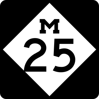
M-25 is a state trunkline highway in the US state of Michigan. The route follows an arc-like shape closely along the Lake Huron shore of the Thumb in the eastern Lower Peninsula between Port Huron and Bay City. It serves the lakeshore resorts along Lake Huron and Saginaw Bay and generally lies within sight of the lake and the bay. All is surface road and generally scenic, except for the freeway segment near the junction with Interstate 75 (I-75) and connection into the US Highway 10 (US 10) freeway.

<span class="mw-page-title-main">M-28 (Michigan highway)</span> State highway in Michigan, United States

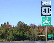
M-28 is an east–west state trunkline highway that traverses nearly all of the Upper Peninsula of the U.S. state of Michigan, from Wakefield to near Sault Ste. Marie in Bruce Township. Along with US Highway 2 (US 2), M-28 forms a pair of primary highways linking the Upper Peninsula from end to end, providing a major access route for traffic from Michigan and Canada along the southern shore of Lake Superior. M-28 is the longest state trunkline in Michigan numbered with the "M-" prefix at 290.373 miles (467.310 km). The entire highway is listed on the National Highway System, while three sections of M-28 are part of the Lake Superior Circle Tour. M-28 also carries two memorial highway designations along its route.

<span class="mw-page-title-main">M-129 (Michigan highway)</span> State highway in Mackinac and Chippewa counties in Michigan, United States

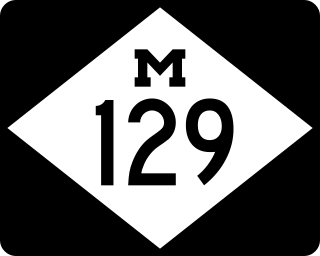
M-129 is a state trunkline highway in the Upper Peninsula (UP) of the US state of Michigan. It runs from Cedarville to Sault Ste. Marie. South of Nine Mile Road in Chippewa County, M-129 overlays the Michigan Meridian. The section of M-129 that overlays the meridian is named Meridian Road. The highway between M-48 and the northern terminus is a part of the larger Lake Huron Circle Tour.

<span class="mw-page-title-main">M-35 (Michigan highway)</span> State highway in Michigan, United States

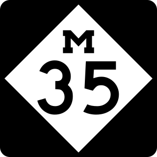
M-35 is a state trunkline highway in the Upper Peninsula (UP) of the US state of Michigan. It runs for 128 miles (206 km) in a general north–south direction and connects the cities of Menominee, Escanaba, and Negaunee. The southern section of M-35 in Menominee and Delta counties carries two additional designations; M-35 forms a segment of the Lake Michigan Circle Tour, and it is the UP Hidden Coast Recreational Heritage Trail, which is a part of what is now called the Pure Michigan Byways Program. Along the southern section, the highway is the closest trunkline to the Green Bay, a section of Lake Michigan. The northern section of the highway turns inland through sylvan areas of the UP, connecting rural portions of Delta and Marquette counties.

<span class="mw-page-title-main">M-134 (Michigan highway)</span> State highway in Mackinac and Chippewa counties in Michigan, United States

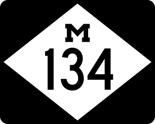
M-134 is an east–west state trunkline highway in the Upper Peninsula (UP) of the US state of Michigan. It connects Interstate 75 (I-75) north of St. Ignace with the communities of Hessel, Cedarville and De Tour Village along Lake Huron. East of De Tour, the highway crosses the De Tour Passage on a ferry to run south of the community of Drummond on Drummond Island. It is one of only three state trunklines in Michigan on islands; the others are M-154 on Harsens Island and M-185 on Mackinac Island. M-134 is also one of only two highways to utilize a ferry in Michigan; the other is US Highway 10 (US 10) which crosses Lake Michigan from Manitowoc, Wisconsin, to Ludington. Most of the mainland portion of M-134 is also part of the Lake Huron Circle Tour, and since 2015, it has been a Pure Michigan Byway under the name M-134 North Huron Byway.

<span class="mw-page-title-main">U.S. Route 12 in Indiana</span>

U.S. Route 12 (US 12) is a part of the United States Numbered Highway System that runs from Aberdeen, Washington, to Detroit, Michigan. In the U.S. state of Indiana, it is part of the state road system. US 12 enters the state concurrent with US 20 and US 41 in Whiting. The 46.258 miles (74.445 km) of US 12 that lie within Indiana serve as a major conduit. Some of the highway is listed on the National Highway System (NHS). Various sections are rural two-lane highway, urbanized four-lane undivided highway, and one-way streets. The easternmost community along the highway is Michiana Shores at the Michigan state line.

<span class="mw-page-title-main">Interstate 75 in Michigan</span> Interstate Highway in Michigan, United States

Interstate 75 (I-75) is a part of the Interstate Highway System that runs north–south from Miami, Florida, to Sault Ste. Marie in the Upper Peninsula of the US state of Michigan. I-75 enters the state from Ohio in the south, north of Toledo, and runs generally northward through Detroit, Pontiac and Bay City, crosses the Mackinac Bridge, and ends at the Canadian border in Sault Ste. Marie. The freeway runs for approximately 396 miles (637 km) on both of Michigan's major peninsulas. The landscapes traversed by I-75 include Southern Michigan farmland, northern forests, suburban bedroom communities, and the urban core of Detroit. The freeway also uses three of the state's monumental bridges to cross major bodies of water. There are four auxiliary Interstates in the state related to I-75, as well as nine current or former business routes, with either Business Loop I-75 or Business Spur I-75 designations.

<span class="mw-page-title-main">Wisconsin Highway 13</span>

State Trunk Highway 13 is a state highway running north–south across northwest and central Wisconsin. WIS 13 serves as a major north–south route connecting the communities of Wisconsin Dells, Wisconsin Rapids, Marshfield and Ashland. WIS 13 is part of the Lake Superior Circle Tour from its northern/western terminus to Ashland at is eastern junction with U.S. Highway 2 (US 2). The road also provides access to the Apostle Islands National Lakeshore off the Lake Superior shoreline at Bayfield. The highway is two-lane surface road with the exception of various urban multilane road sections.

<span class="mw-page-title-main">Wisconsin Highway 42</span> Highway in Wisconsin

State Trunk Highway 42 is a state highway in the U.S. state of Wisconsin. It runs for 135 miles (217 km) north–south in northeast Wisconsin from Sheboygan to the ferry dock in Northport. Much of the highway is part of the Lake Michigan Circle Tour from the eastern junction with U.S. Highway 10 (US 10) in Manitowoc to its junction with WIS 57 in Sister Bay. WIS 42 parallels I-43 from Sheboygan to Manitowoc, and parallels WIS 57 throughout much of the route, particularly from Manitowoc to Sturgeon Bay, meeting the northern terminus of WIS 57 in Sister Bay.

<span class="mw-page-title-main">U.S. Route 12 in Wisconsin</span>

U.S. Highway 12 in the U.S. state of Wisconsin runs east–west across the western to southeast portions of the state. It enters from Minnesota running concurrently with Interstate 94 (I-94) at Hudson, parallels the Interstate to Wisconsin Dells, and provides local access to cities such as Menomonie, Eau Claire, Black River Falls, Tomah, and Mauston. It then provides an alternative route for traffic between northwestern Wisconsin and Madison and is the anchor route for the Beltline Highway around Madison. Finally, it serves southeastern Wisconsin, connecting Madison with Fort Atkinson, Whitewater, Elkhorn, and Lake Geneva. The West Beltline Highway and the segment between Elkhorn and Genoa City are freeways, and the segment between Sauk City and Middleton is an expressway. The remainder of the road is a two-lane surface road or an urban multilane arterial. Between Hudson and west of Warrens, the road closely parallels the former main line of the Chicago, St. Paul, Minneapolis and Omaha Railway, now operated by Union Pacific Railroad.

<span class="mw-page-title-main">U.S. Route 31 in Michigan</span> U.S. Highway in Michigan

US Highway 31 (US 31) is a part of the United States Numbered Highway System that runs from Alabama to the Lower Peninsula of the US state of Michigan. In Michigan, it is a state trunkline highway that runs from the Indiana–Michigan state line at Bertrand Township north to its terminus at Interstate 75 (I-75) south of Mackinaw City. Along its 355.2-mile-long (571.6 km) route, US 31 follows the Michigan section of the St. Joseph Valley Parkway as well as other freeways and divided highways northward to Ludington. North of there, the trunkline is a rural undivided highway through the Northern Michigan tourist destinations of Traverse City and Petoskey before terminating south of Mackinaw City. Along its route, US 31 has been dedicated in memory of a few different organizations, and sections of it carry the Lake Michigan Circle Tour (LMCT) moniker. Four bridges used by the highway have been recognized for their historic character as well.

<span class="mw-page-title-main">Interstate 69 in Michigan</span> Interstate Highway in Michigan, United States

Interstate 69 (I-69) is a part of the Interstate Highway System that will eventually run from the Mexican border in Texas to the Canadian border at Port Huron, Michigan. In Michigan, it is a state trunkline highway that enters the state south of Coldwater and passes the cities of Lansing and Flint in the Lower Peninsula. A north–south freeway from the Indiana–Michigan border to the Lansing area, it changes direction to east–west after running concurrently with I-96. The freeway continues to Port Huron before terminating in the middle of the twin-span Blue Water Bridge while running concurrently with I-94 at the border. There are four related business loops for I-69 in the state, connecting the freeway to adjacent cities.

<span class="mw-page-title-main">Business routes of Interstate 75 in Michigan</span> Highways in Michigan

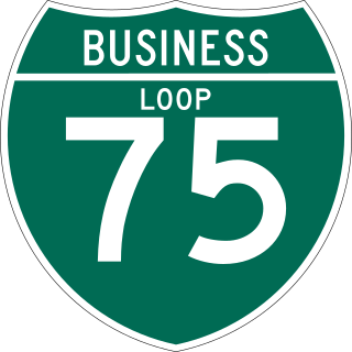
There have been nine business routes for Interstate 75 in the US state of Michigan. Numbered either Business Loop Interstate 75 or Business Spur Interstate 75 depending if they are a full business loop or a business spur, these highways are former routings of I-75's predecessor highways in the state. They were designated as I-75 was completed through the various areas of Michigan. The business loop in Pontiac runs through that city's downtown along a section of Woodward Avenue and a segment of roadway formerly used by M-24. The former Saginaw business loop was once a part of US Highway 23 (US 23), as was most of the original Bay City business loop. The roadways that make up the business loops in West Branch and Roscommon were previously part of M-76, I-75's predecessor through that part of the state. In Northern Michigan, the Grayling and Gaylord BL I-75s were part of US 27, and the two business routes in St. Ignace and Sault Ste. Marie in the Upper Peninsula of Michigan were part of US 2. A tenth business route, a loop through Indian River has been proposed. Each of the business loops connects to I-75 on both ends and runs through their respective cities' downtown areas. The two business spurs only connect to I-75 on one end and run into the appropriate downtown.

<span class="mw-page-title-main">U.S. Route 2 in Michigan</span> U.S. Highway in Michigan

US Highway 2 (US 2) is a component of the United States Numbered Highway System that connects Everett, Washington, to the Upper Peninsula (UP) of the US state of Michigan, with a separate segment that runs from Rouses Point, New York, to Houlton, Maine. In Michigan, the highway runs through the UP in two segments as a part of the state trunkline highway system, entering the state at Ironwood and ending at St. Ignace; in between, US 2 briefly traverses the state of Wisconsin. As one of the major transportation arteries in the UP, US 2 is a major conduit for traffic through the state and neighboring northern Midwest states. Two sections of the roadway are included as part of the Great Lakes Circle Tours, and other segments are listed as state-designated Pure Michigan Byways. There are several memorial highway designations and historic bridges along US 2 that date to the 1910s and 1920s. The highway runs through rural sections of the UP, passing through two national and two state forests in the process.

<span class="mw-page-title-main">Sault Ste. Marie, Ontario</span> City in Ontario, Canada

Sault Ste. Marie is a city in Ontario, Canada. The third-largest city in Northern Ontario after Sudbury and Thunder Bay, it is located on the St. Mary's River on the Canada–US border. To the southwest, across the river, is the United States and the Michigan city of the same name. The two cities are joined by the Sault Ste. Marie International Bridge, which connects Interstate 75 on the Michigan side and Huron Street on the Ontario side. Shipping traffic in the Great Lakes system bypasses the Saint Mary's Rapids via the American Soo Locks, the world's busiest canal in terms of tonnage that passes through it, while smaller recreational and tour boats use the Canadian Sault Ste. Marie Canal.

<span class="mw-page-title-main">Wisconsin State Trunk Highway System</span>

The Wisconsin State Trunk Highway System is the state highway system of the U.S. state of Wisconsin, including Wisconsin's segments of the Interstate Highway System and the United States Numbered Highway System, in addition to its other state trunk highways. These separate types of highways are respectively designated with an I-, US, or STH- prefix. The system also includes minor roads designated as Scenic Byways, four routes intended to promote tourism to scenic and historic areas of the state; and as Rustic Roads, lightly traveled and often unpaved local roads which the state has deemed worthy of preservation and protection. The state highway system, altogether totaling 11,753 miles (18,915 km) across all of Wisconsin's 72 counties, is maintained by the Wisconsin Department of Transportation (WisDOT).

References

  1. 1 2 3 Great Lakes Commission. "Great Lakes Circle Tour". Great Lakes Commission. Archived from the original on July 25, 2010. Retrieved March 8, 2008.
  2. Michigan Department of Transportation (2007). Michigan: Official Department of Transportation Map (Map). c. 1:975,000. Lansing: Michigan Department of Transportation. OCLC   42778335. Archived from the original on August 27, 2019. Retrieved August 26, 2019 via Archives of Michigan.
  3. Geomatics Office (1990). Ontario Official Road Map (Map). Government of Ontario.
  4. 1 2 Great Lakes Commission. "Great Lakes Circle Tour: Lake Superior". Great Lakes Commission. Retrieved March 8, 2008.
  5. 1 2 3 4 Great Lakes Commission. "Great Lakes Circle Tour: Lake Michigan". Great Lakes Commission. Retrieved April 20, 2008.
  6. Office of Management and Budget. List II Consolidated Metropolitan Statistical Areas and Primary Metropolitan Statistical Areas (PDF) (Report). Executive Office of the President. Archived from the original (PDF) on September 13, 2001. Retrieved November 29, 2011.
  7. 1 2 3 4 Indiana 2009 Travel Guide. Indianapolis: State of Indiana. 2009.
  8. 1 2 Northwest Indiana Bike Map (Map) (Spring ed.). Northwestern Indiana Regional Planning Commission. 2008.
  9. 1 2 Moore, Powell A. (1959). The Calumet Region, Indiana's Last Frontier. Indiana Historical Bureau.
  10. 1 2 3 Michigan Department of Transportation (2023). Michigan: Official 2023 Michigan Transportation Map (PDF) (Map). c. 1:975,000. Lansing: Michigan Department of Transportation.
  11. 1 2 Bessert, Christopher J. (January 1, 2009). "Lake Huron Circle Tour". Michigan Highways. Retrieved July 18, 2009.[ self-published source ]
  12. Michigan Department of Transportation (2009). Michigan: Official Department of Transportation Map (Map). c. 1:975,000. Lansing: Michigan Department of Transportation. OCLC   42778335.
  13. Fling, Jake (October 10, 2010). "Travel the Great Lakes Seaway Trail". Erie Times-News . Retrieved November 20, 2010.
  14. Mitchell, Teresa (June 18, 2010). "June 22–24 Great Lakes Seaway Trail Reveal & Economic Impact Road Show Visits Six Communities on America's Byway" (Press release). Seaway Trail, Inc. Archived from the original on January 6, 2011. Retrieved November 20, 2010.
  15. Davis, R. Matt (May 1, 1986). "Signs to Mark Lake Circle Tour". Daily Mining Gazette. Houghton, MI. p. 16.
  16. Great Lakes Commission. "Tourism: The Great Lakes Circle Tour on GLIN!". Great Lakes Commission. Archived from the original on February 16, 2008. Retrieved March 8, 2008.

Works cited