Anchor Bay (Michigan)

Last updated
Anchor Bay
Michigan Macomb county Lake St Clair Anchor Bay Selfridge AFB IMG 1817.JPG
Aerial view of the Anchor Bay from the south towards north, over Macomb County
Relief map of USA Michigan.png
Red pog.svg
Anchor Bay
Usa edcp relief location map.png
Red pog.svg
Anchor Bay
Location(Great Lakes)
Coordinates 42°37′N82°43′W / 42.617°N 82.717°W / 42.617; -82.717 Coordinates: 42°37′N82°43′W / 42.617°N 82.717°W / 42.617; -82.717
Type Freshwater Bay
Primary inflows St. Clair River, Clinton River, Black Creek and Salt River.
Primary outflows Lake St. Clair and then to the Detroit River
Basin  countries United States, Canada
Max. length9 mi (14 km) [1]
Max. width10 mi (16 km) [1]
Surface area90 sq mi (233 km2) [1] [2]
Islands Strawberry Island, and the tips of Dickinson and Harsens Island
Settlements Detroit

Anchor Bay is a freshwater bay forming the northern region of Lake St. Clair in the U.S. state of Michigan. It generally encompasses the waters north of a line between Huron Point (part of the Lake St. Clair Metro Park Beach, not to be confused with Port Huron) and the Middle Channel of the St. Clair River (which enters Lake St. Clair between Dickinson Island and Harsens Island). It covers over 90 square miles (230 km2) and a depth of from 1 to 11 feet (0.30 to 3.35 m), which is unusually shallow for its immense size.

Contents

Geography

The bay is about 25 miles (40 km) northeast of downtown Detroit, Michigan. It is just south of New Baltimore, Michigan and borders the townships of Harrison, Clinton, Chesterfield, Anchorville, Ira, Fair Haven, Clay, and several islands including Dickinson and Harsens. It is notable for the fact that Canadian waters lie to the south of the adjacent United States territory and make up a major portion of Lake Saint Clair.

Anchor Bay measures over 8 nautical miles (15 km; 9.2 mi) from north to south and over 9 nautical miles (17 km; 10 mi) from east to west. It is fed by the St. Clair River, which flows southwards from Lake Huron and has an extensive river delta where it enters Lake Saint Clair, the largest delta of the Great Lakes System. [1] [2] This bay is part of the Great Lakes System.

Naming

As early as 1710, the English identified the lake on their maps as Saint Clare. By the Mitchell Map in 1755, the spelling appeared as St. Clair, the form that became most widely used. [3] Some scholars believe the name honors American Revolutionary War General Arthur St. Clair, later Governor of the Northwest Territory; however, the name Lake St. Clair was in use, with its current spelling, long before St. Clair became a notable figure. The lake's name and the general's name likely influenced the namings of St. Clair County, the township of St. Clair, and the cities of St. Clair and St. Clair Shores.

The name's origin has also been confused with Patrick Sinclair, a British officer who purchased land on the St. Clair River at the outlet of the Pine River. There, in 1764, he built Fort Sinclair, in use for nearly 20 years before it was abandoned. [4]

Unlike most smaller lakes in the region—but like the Great Lakes—Lake occurs first in its name rather than at the end, reflecting its French origins.

Water quality

Anchor Bay is a part of the largest freshwater delta in the Great Lakes. Its current water quality is quite good despite past pollution incidents and a history of chemical bio-accumulation. A number of cities obtain their drinking water from or just downstream of the lake, and quality is closely monitored. [5] [6]

In the early 1970s, the Canadian and American governments closed the commercial fishery over concerns of bio-accumulation of mercury caused by the Dow Chemical Chlor-Alkali Plant in Sarnia, Ontario. Since 1949, Dow operated mercury cell plants there for the production of chlorine and other chemicals, discharging mercury into the river and contaminating the fishery. The fishery has remained closed, although studies indicate mercury levels are now well within safe ranges. [7]

Boat clubs

Many yacht clubs (boating and sailing clubs) are along the lake's shores, including:

Public beaches

Fauna

Many of North America's freshwater fish species are found in the lake throughout the seasons. Species popular with anglers include bass, bluegill, bullhead, catfish, muskellunge, northern Pike, perch, salmon, smelt, steelhead, sturgeon, trout, and walleye. Several invasive species also inhabit the lake, including zebra mussels, sea lampreys, alewives and round gobies.

See also

Footnotes

  1. 1 2 3 4 Lake St. Clair summary report Archived 2016-04-16 at the Wayback Machine .Great Lakes.net. Retrieved on December 2, 2007.
  2. 1 2 "Chapter 1:Introduction to Lake St. Clair and the St. Clair River". U.S. government U.S. Army. June 2004. Archived from the original on 2009-01-10. Retrieved 2008-06-08.
  3. Jenks, pp. 23-24
  4. Fuller, pp. 21-22
  5. "water quality in Windsor". Archived from the original on 2015-02-16. Retrieved 2015-02-15.
  6. "Thames - Sydenham & Region Drinking Water Source Protection" . Retrieved 2015-02-15.
  7. "Mercury in Lake St. Clair Walleye" . Retrieved 2015-02-15.
  8. "Clinton River Boat Club," . Retrieved 2015-08-12.
  9. "Albatross Yacht Club," . Retrieved 2015-02-15.
  10. "North Star Sail Club" . Retrieved 2015-02-04.

Related Research Articles

Great Lakes Group of lakes in North America

The Great Lakes, also called the Great Lakes of North America or the Laurentian Great Lakes, is a series of large interconnected freshwater lakes in the mid-east region of North America that connect to the Atlantic Ocean via the Saint Lawrence River. They are Lakes Superior, Michigan, Huron, Erie, and Ontario and are in general on or near the Canada–United States border. Hydrologically, there are four lakes, because lakes Michigan and Huron join at the Straits of Mackinac. The Great Lakes Waterway enables travel by water among the lakes.

Lake Michigan One of the Great Lakes of North America

Lake Michigan is one of the five Great Lakes of North America. It is the second-largest of the Great Lakes by volume and the third-largest by surface area, after Lake Superior and Lake Huron. To the east, its basin is conjoined with that of Lake Huron through the narrow Straits of Mackinac, giving it the same surface elevation as its easterly counterpart; the two are technically a single lake.

Lake Huron One of the Great Lakes of North America

Lake Huron is one of the five Great Lakes of North America. Hydrologically, it comprises the easterly portion of Lake Michigan–Huron, having the same surface elevation as its westerly counterpart, to which it is connected by the 5-mile-wide (8.0 km), 20-fathom-deep Straits of Mackinac. It is shared on the north and east by the Canadian province of Ontario and on the south and west by the U.S. state of Michigan. The name of the lake is derived from early French explorers who named it for the Huron people inhabiting the region. The Huronian glaciation was named from evidence collected from Lake Huron region. The northern parts of the lake include the North Channel and Georgian Bay. Saginaw Bay is located in the southwest corner of the lake. The main inlet is the St. Marys River, and the main outlet is the St. Clair River.

St. Clair County, Michigan County in Michigan, United States

St. Clair County is a county located in the U.S. state of Michigan and bordering the west bank of the St. Clair River. As of the 2020 Census, the population was 160,383. It is the 13th-most populous county in the state. The county seat is Port Huron, located at the north end of the St. Clair River at Lake Huron. The county was created September 10, 1820, and its government was organized in 1821. Located northeast of Detroit, St. Clair County is part of the Detroit-Warren-Dearborn, MI Metropolitan Statistical Area. Geographically, it lies in the Thumb area of eastern Michigan.

Port Huron, Michigan City in Michigan, United States

Port Huron is a city in the U.S. state of Michigan and the county seat of St. Clair County. The population was 30,184 at the 2010 census. The city is adjacent to Port Huron Township but is administered separately.

St. Clair River

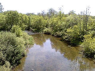
The St. Clair River is a 40.5-mile-long (65.2 km) river in central North America which flows from Lake Huron into Lake St. Clair, forming part of the international boundary between the Canadian province of Ontario and the United States at Michigan. The river is a significant component in the Great Lakes Waterway, whose shipping channels permit cargo vessels to travel between the upper and lower Great Lakes.

Lake St. Clair

Lake St. Clair is a freshwater lake that lies between the Canadian province of Ontario and the U.S. state of Michigan. It was named in 1679 by French Catholic explorers after Saint Clare of Assisi, on whose feast day they first sighted this body of water.

The Thumb

The Thumb is a region and a peninsula of the U.S. state of Michigan, so named because the Lower Peninsula is shaped like a mitten. The Thumb area is generally considered to be in the Central Michigan region, east of the Tri-Cities and north of Metro Detroit. The region is also branded as the Blue Water Area.

Clinton River (Michigan)

The Clinton River is a river in southeastern Michigan in the United States. It is named in honor of DeWitt Clinton, who was governor of New York from 1817 to 1823.

Harsens Island

Harsens Island is a wet marshy location at the mouth of the St. Clair River on Lake St. Clair, in the U.S. state of Michigan. Politically, the island is in Clay Township of St. Clair County

Saginaw Bay

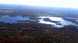
Saginaw Bay is a bay within Lake Huron located on the eastern side of the U.S. state of Michigan. It forms the space between Michigan's Thumb region and the rest of the Lower Peninsula of Michigan. Saginaw Bay is 1,143 square miles (2,960 km2) in area. It is located in parts of five Michigan counties: Arenac, Bay, Huron, Iosco, and Tuscola.

M-29 is a state trunkline highway in the US state of Michigan that runs in a south–north direction from Chesterfield Township to Marysville. It generally runs along the shore of Lake St. Clair and the St. Clair River.

Tashmoo Park was an amusement park in Algonac, Michigan. Opened in 1897, it closed in 1951. Most of it was later demolished, though the dance pavilion remains today, used by a marina to store recreational boats over the winter.

Potagannissing Bay Bay in Michigan

Potagannissing Bay is a shallow, island-strewn bay on Lake Huron in Algoma District, Ontario, Canada and Chippewa County, Michigan, United States. It is bounded by the land masses of St. Joseph Island, Ontario at the northwest and Drummond Island, Michigan at the southeast, and by the water bodies the Saint Marys River and the De Tour Passage at the southwest and the North Channel at the northeast. The bay is northeast of De Tour Village, Chippewa County. The bay's waters are rich in freshwater fish.

Kent Lake (Michigan)

Kent Lake is a 1,200-acre reservoir lake formed by damming the Huron River near its headwaters. Kent Lake is mostly located in Oakland County, Michigan in Milford and Lyon Townships, with a small portion including its dam located in Green Oak Township, Livingston County, Michigan.

References