
The Mississippi River is the second-longest river and chief river of the second-largest drainage system on the North American continent, second only to the Hudson Bay drainage system. From its traditional source of Lake Itasca in northern Minnesota, it flows generally south for 2,320 miles (3,730 km) to the Mississippi River Delta in the Gulf of Mexico. With its many tributaries, the Mississippi's watershed drains all or parts of 32 U.S. states and two Canadian provinces between the Rocky and Appalachian mountains. The main stem is entirely within the United States; the total drainage basin is 1,151,000 sq mi (2,980,000 km2), of which only about one percent is in Canada. The Mississippi ranks as the fourth-longest river and fifteenth-largest river by discharge in the world. The river either borders or passes through the states of Minnesota, Wisconsin, Iowa, Illinois, Missouri, Kentucky, Tennessee, Arkansas, Mississippi, and Louisiana.

Douglas County is a county located at the northwest corner of the U.S. state of Wisconsin. As of the 2010 census, the population was 44,159. Its county seat is Superior.

Pine County is a county in the U.S. state of Minnesota. As of the 2010 United States Census, the population was 29,750. Its county seat is Pine City. The county was formed in 1856 and organized in 1872.

Fountain City is a small city bordering the Mississippi River in Buffalo County, Wisconsin, USA.

Green Bay is an arm of Lake Michigan, located along the south coast of Michigan's Upper Peninsula and the east coast of Wisconsin. It is separated from the rest of the lake by the Door Peninsula in Wisconsin, the Garden Peninsula in Michigan, and the chain of islands between them, all formed by the Niagara Escarpment. Green Bay is some 120 miles (193 km) long, with a width ranging from about 10 to 20 miles ; it is 1,626 square miles (4,210 km2) in area.

The Town of Superior is a town in Douglas County, Wisconsin, United States. The population was 2,058 at the 2000 census. The Village of Superior is located within the town. The City of Superior is located immediately north and adjacent to both the Town of Superior and the Village of Superior.

The Fox River is a river in eastern Wisconsin in the Great Lakes region of the United States. It is the principal tributary of the Bay of Green Bay, and via the Bay, the largest tributary of Lake Michigan. The well-known city of Green Bay, one of the first European settlements in North America, is on the river at its mouth on lower Green Bay.
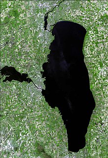
Lake Winnebago is a shallow freshwater lake in the north central United States, located in east central Wisconsin. At 137,700 acres it is the largest lake entirely within the state, covering an area of about 30 miles by 10 miles, with 88 miles of shoreline, an average depth of 15.5 feet, and a maximum depth of 21 feet. It has many shallow reefs along the west shore, and a drop-off type shoreline on the east. There are several islands along the west shore.

The Saint Louis River is a river in the U.S. states of Minnesota and Wisconsin that flows into Lake Superior. The largest U.S. river to flow into the lake, it is 192 miles (309 km) in length and starts 13 miles (21 km) east of Hoyt Lakes, Minnesota. The river's watershed covers 3,634 square miles (9,410 km2). Near the Twin Ports of Duluth, Minnesota and Superior, Wisconsin, the river becomes a freshwater estuary. The lower St. Louis is the only river in the state with whitewater rafting opportunities.
The Menominee River is a river in northwestern Michigan and northeastern Wisconsin in the United States. It is approximately 116 miles (187 km) long, draining a rural forested area of northern Wisconsin and the Upper Peninsula of Michigan into Lake Michigan. Its entire course, with that of its tributary, the Brule River, forms part of the boundary between the two states.

The Montreal River is a river flowing to Lake Superior in northern Wisconsin and the Upper Peninsula of Michigan in the United States. It is 47.8 miles (76.9 km) long and drains approximately 270 square miles (700 km2) in a forested region. For most of its length, the river's course defines a portion of the Wisconsin–Michigan border. The Ojibwe name for the river is Gaa-waasijiwaang, meaning "where there is whitewater".
Mississippi River Band of Chippewa Indians or simply the Mississippi Chippewa, are a historical Ojibwa Band inhabiting the headwaters of the Mississippi River and its tributaries in present-day Minnesota.

The Snake River is a 104-mile-long (167 km) tributary of the St. Croix River in east-central Minnesota in the United States. It is one of three streams in Minnesota with this name. Its name is a translation from the Ojibwa Ginebigo-ziibi, after the Dakota peoples who made their homes along this river. Kanabec County's name is derived from the Ojibwe word for this river.

Pokegama is an unincorporated community in Pokegama Township, Pine County, Minnesota, United States; along the Pokegama Lake. Its name in Ojibwe is Bakegamaang, meaning "at the side-lake", referring to Pokegama Lake's position to the Snake River.
The Pokegama River is a 26.3-mile-long (42.3 km) river in Wisconsin and Minnesota in the United States. It is a tributary of the Saint Louis River, joining it in the western part of the city of Superior, Wisconsin.
Pokegama is an unincorporated community located in the town of Superior, Douglas County, Wisconsin, United States.
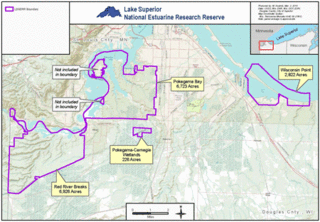
The Lake Superior National Estuarine Research Reserve includes land and water areas along the St. Louis River and Lake Superior in Douglas County, in the northwest corner of Wisconsin, United States. It is one of 29 National Estuarine Research Reserves. The Reserve is operated as a program of the Natural Resources Institute of the University of Wisconsin-Madison Division of Extension. It has an area of 16,697 acres (6,757 ha), and was designated in 2010.


