Related Research Articles

Erosion is the action of surface processes that removes soil, rock, or dissolved material from one location on the Earth's crust, and then transports it to another location where it is deposited. Erosion is distinct from weathering which involves no movement. Removal of rock or soil as clastic sediment is referred to as physical or mechanical erosion; this contrasts with chemical erosion, where soil or rock material is removed from an area by dissolution. Eroded sediment or solutes may be transported just a few millimetres, or for thousands of kilometres.
Soil erosion is the denudation of the upper layer of soil. It is a form of soil degradation. This natural process is caused by the dynamic activity of erosive agents, that is, water, ice (glaciers), snow, air (wind), plants, and animals. In accordance with these agents, erosion is sometimes divided into water erosion, glacial erosion, snow erosion, wind (aeolean) erosion, zoogenic erosion and anthropogenic erosion such as tillage erosion. Soil erosion may be a slow process that continues relatively unnoticed, or it may occur at an alarming rate causing a serious loss of topsoil. The loss of soil from farmland may be reflected in reduced crop production potential, lower surface water quality and damaged drainage networks. Soil erosion could also cause sinkholes.

The Interior Plains are a vast physiographic region that spreads across the Laurentian craton of central North America, extending along the east flank of the Rocky Mountains from the Gulf Coast region to the Arctic Beaufort Sea. In Canada, it encompasses the Canadian Prairies separating the Canadian Rockies from the Canadian Shield, as well as the Boreal Plains and Taiga Plains east of the Mackenzie and Richardson Mountains; while in the United States, it includes the Great Plains of the West/Midwest and the tallgrass prairie region to the south of the Great Lakes extending east to the Appalachian Plateau region.
Natural Resources Conservation Service (NRCS), formerly known as the Soil Conservation Service (SCS), is an agency of the United States Department of Agriculture (USDA) that provides technical assistance to farmers and other private landowners and managers.

The wetlands of Louisiana are water-saturated coastal and swamp regions of southern Louisiana, often called 'Bayou'.
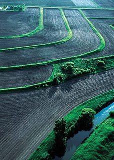
Erosion control is the practice of preventing or controlling wind or water erosion in agriculture, land development, coastal areas, river banks and construction. Effective erosion controls handle surface runoff and are important techniques in preventing water pollution, soil loss, wildlife habitat loss and human property loss.

Nonpoint source (NPS) pollution refers to diffuse contamination of water or air that does not originate from a single discrete source. This type of pollution is often the cumulative effect of small amounts of contaminants gathered from a large area. It is in contrast to point source pollution which results from a single source. Nonpoint source pollution generally results from land runoff, precipitation, atmospheric deposition, drainage, seepage, or hydrological modification where tracing pollution back to a single source is difficult. Nonpoint source water pollution affects a water body from sources such as polluted runoff from agricultural areas draining into a river, or wind-borne debris blowing out to sea. Nonpoint source air pollution affects air quality, from sources such as smokestacks or car tailpipes. Although these pollutants have originated from a point source, the long-range transport ability and multiple sources of the pollutant make it a nonpoint source of pollution; if the discharges were to occur to a body of water or into the atmosphere at a single location, the pollution would be single-point.

Surface runoff is the flow of water occurring on the ground surface when excess rainwater, stormwater, meltwater, or other sources, can no longer sufficiently rapidly infiltrate in the soil. This can occur when the soil is saturated by water to its full capacity, and the rain arrives more quickly than the soil can absorb it. Surface runoff often occurs because impervious areas do not allow water to soak into the ground. Furthermore, runoff can occur either through natural or man-made processes. Surface runoff is a major component of the water cycle. It is the primary agent of soil erosion by water. The land area producing runoff that drains to a common point is called a drainage basin.
The Universal Soil Loss Equation (USLE) is a widely used mathematical model that describes soil erosion processes.
The Water Resources Development Act of 1986 is part of Pub.L. 99–662, a series of acts enacted by Congress of the United States on November 17, 1986.
The Water Resources Development Act of 1996 is part of Pub.L. 104–303 (text)(PDF), was enacted by Congress of the United States on October 12, 1996. Most of the provisions of WRDA 1996 are administered by the United States Army Corps of Engineers.
Water Resources Development Act of 1988, Pub.L. 100–676, is a public law passed by Congress on November 17, 1988 concerning water resources in the United States in the areas of flood control, navigation, dredging, environment, recreation, water supply, beach nourishment and erosion.
The Water Resources Development Act of 1992, Pub.L. 102–580, was enacted by Congress of the United States on October 31, 1992. Most of the provisions of WRDA 1992 are administered by the United States Army Corps of Engineers.
The Water Resources Development Act of 1999, Pub.L. 106–53 (text)(PDF), was enacted by Congress of the United States on August 17, 1999. Most of the provisions of WRDA 1999 are administered by the United States Army Corps of Engineers.
The Water Resources Development Act of 2000, Pub.L. 106–541 (text)(PDF), was enacted by Congress of the United States on December 11, 2000. Most of the provisions of WRDA 2000 are administered by the United States Army Corps of Engineers.

A sediment control is a practice or device designed to keep eroded soil on a construction site, so that it does not wash off and cause water pollution to a nearby stream, river, lake, or sea. Sediment controls are usually employed together with erosion controls, which are designed to prevent or minimize erosion and thus reduce the need for sediment controls. Sediment controls are generally designed to be temporary measures, however, some can be used for storm water management purposes.

A silt fence, sometimes (misleadingly) called a "filter fence," is a temporary sediment control device used on construction sites to protect water quality in nearby streams, rivers, lakes and seas from sediment in stormwater runoff. Silt fences are widely used on construction sites in North America and elsewhere, due to their low cost and simple design. However, their effectiveness in controlling sediment can be limited, due to problems with poor installation, proper placement, and/or inadequate maintenance.

A sediment basin is a temporary pond built on a construction site to capture eroded or disturbed soil that is washed off during rain storms, and protect the water quality of a nearby stream, river, lake, or bay. The sediment-laden soil settles in the pond before the runoff is discharged. Sediment basins are typically used on construction sites of 5 acres (20,000 m2) or more, where there is sufficient room. They are often used in conjunction with erosion controls and other sediment control practices. On smaller construction sites, where a basin is not practical, sediment traps may be used.

The Environmental Quality Incentives Program (EQIP) is a United States government program designed to assist farmers in improving environmental quality, particularly water quality and soil conservation. Congress established the program in the 1996 farm bill to provide primarily cost-sharing assistance, but also technical and educational assistance, aimed at promoting production and environmental quality, and optimizing environmental benefits.
The Water Erosion Prediction Project (WEPP) model is a physically based erosion simulation model built on the fundamentals of hydrology, plant science, hydraulics, and erosion mechanics. The model was developed by an interagency team of scientists to replace the Universal Soil Loss Equation (USLE) and has been widely used in the United States and the world. WEPP requires four inputs, i.e., climate, topography, soil, and management (vegetation); and provides various types of outputs, including water balance, soil detachment and deposition at points along the slope, sediment delivery, and vegetation growth. The WEPP model has been improved continuously since its public delivery in 1995, and is applicable for a variety of areas.
References
![]() This article incorporates public domain material from the Congressional Research Service document: Jasper Womach. "Report for Congress: Agriculture: A Glossary of Terms, Programs, and Laws, 2005 Edition" (PDF).
This article incorporates public domain material from the Congressional Research Service document: Jasper Womach. "Report for Congress: Agriculture: A Glossary of Terms, Programs, and Laws, 2005 Edition" (PDF).