Victoria Island is a large island in the Arctic Archipelago that straddles the boundary between Nunavut and the Northwest Territories of Canada. It is the eighth largest island in the world, and at 217,291 km2 (83,897 sq mi) in area, it is Canada's second largest island. It is nearly double the size of Newfoundland (111,390 km2 [43,010 sq mi]), and is slightly larger than the island of Great Britain (209,331 km2 [80,823 sq mi]) but smaller than Honshu (225,800 km2 [87,200 sq mi]). The western third of the island lies in the Inuvik Region of the Northwest Territories; the remainder is part of Nunavut's Kitikmeot Region.

The Ottawa River is a river in the Canadian provinces of Ontario and Quebec. It is named in honour of the Algonquin word 'to trade', as it was the major trade route of Eastern Canada at the time. For most of its length, it defines the border between these two provinces. It is a major tributary of the St. Lawrence River and the longest river in Quebec.

Whitefish Bay is a large bay on the eastern end of Lake Superior between Michigan, United States, and Ontario, Canada. It is located between Whitefish Point in Michigan and Whiskey Point along the more rugged, largely wilderness Canadian Shield of Ontario. The international border runs through the bay, which is heavily used by shipping traffic northbound from and southbound to the Soo Locks.
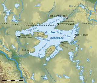
Great Bear Lake is a lake in the boreal forest of Canada. It is the largest lake entirely in Canada, the fourth-largest in North America, and the ninth-largest in the world. The lake is in the Northwest Territories, on the Arctic Circle between 65 and 67 degrees of northern latitude and between 118 and 123 degrees western longitude, 156 m (512 ft) above sea level.

The Goulais River is a river in northern Ontario, Canada, which rises in the Algoma highlands and empties into Goulais Bay on eastern Lake Superior near Sault Ste. Marie, Ontario. It is one of the largest tributaries on the eastern lake, draining an area of approximately 2,000 square kilometres (770 sq mi).
Unorganized North Algoma District is an unorganized area in northeastern Ontario, Canada, comprising all areas in Algoma District, north of the Sault Ste. Marie to Elliot Lake corridor, which are not part of an incorporated municipality or a First Nation. It covers 44,077.03 km2 (17,018.24 sq mi) of land, and had a population of 6050 in 2021. Many of these communities were/are stations on the Algoma Central Railway or were logging/mining towns.

Batchawana Bay is a small bay in Algoma District in Northeastern Ontario, Canada. It is on the eastern shore of Lake Superior, approximately 50 kilometres (31 mi) north of Sault Ste. Marie.
The Whitefish River is a 45 km (28 mi) long river in Thunder Bay District in northwestern Ontario, Canada. It is in the Lake Superior drainage basin, is a tributary of the Kaministiquia River, and is in the centre of the Whitefish River Valley which is the location of several small settlements that grew along the Port Arthur, Duluth and Western Railway.

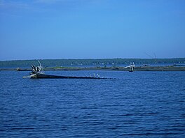
Maple Island is a small island in eastern Whitefish Bay of Lake Superior, located a few kilometres from Canada's shore between Goulais Bay and Batchawana Bay.
Calvert Island is an island in Whitefish Bay, Lake of the Woods in Kenora District, Ontario, Canada. It is about 13 kilometres (8 mi) south of the community of Sioux Narrows and 4 kilometres (2.5 mi) west of Ontario Highway 71.

Lake of Bays is a large lake in the District Municipality of Muskoka in Central Ontario, Canada. It is located almost entirely in the Township municipality of Lake of Bays, which is named after the lake, with the exception of the southwest arm of the lake which is in the Town of Huntsville. Ontario Highway 35 runs north and east of the lake.
West River is an unincorporated community in the geographic township of Mongowin, Sudbury District in Northeastern Ontario, Canada. It is named for the West River, which flows through the community just upstream of its mouth at the Whitefish River.
Batchawana Bay is an unincorporated place and Compact Rural Community in Algoma District in Northeastern Ontario, Canada. It is also the name of a local services board, consisting of parts of the geographic townships of Fisher, Herrick, Ryan and Tilley. It is located north of Sault Ste. Marie, Ontario, on the shores of Batchawana Bay off Lake Superior.
Goulais and District is a local services board in the Canadian province of Ontario. Located in the Algoma District north of Sault Ste. Marie, it encompasses and provides services to the unincorporated townships of Dennis North, Fenwick, Havilland, Kars, Ley, Pennefather, Tupper and Vankoughnet, including the communities of Bellevue, Bourdage Corner, Goulais Bay, Goulais River, Karalash Corners, Kirby's Corner, and Sand Bay.
Whitefish Bay is an unincorporated community on the Lake Michigan shoreline in the town of Sevastopol, Door County, Wisconsin. Native Americans, likely the Menominee, called Whitefish Bay Ah-Quas-He-Ma-Ganing.

The Montreal River is a river in Census Division No. 18, Saskatchewan, Canada. It flows 100 kilometres (62 mi) from Montreal Lake to Lac la Ronge, and is part of the Churchill River and Hudson Bay drainage basins.
The Whitefish River is a river in Census division No. 18 in northern Saskatchewan, Canada. It is in the Hudson Bay and Churchill River drainage basins.
North River may refer to one of five rivers in Ontario, Canada:
Goulais Bay 15A is a First Nations reserve in Algoma District, Ontario, Canada. It lies on Goulais Bay, encompassing most of the unincorporated community of Goulais Mission, and is one of the reserves of the Batchewana First Nation of Ojibways.
The Batchewana First Nation of Ojibways is an Ojibway First Nation in northern Ontario. Their traditional lands run along the eastern shore of Lake Superior, from Batchawana Bay to Whitefish Island. They were reserved this land in the 1850 Robinson Huron Treaty, but surrendered most of it under the 1859 Pennefather Treaty. Through purchase and land claims, it has reclaimed some territories, including Goulais Bay 15A, Obadjiwan 15E, Rankin Location 15D and Whitefish Island.