Painesville, Ohio | |
---|---|
Coordinates: 41°44′22″N81°14′59″W / 41.73944°N 81.24972°W | |
Country | United States |
State | Ohio |
County | Lake |
Settled | 1800 |
Government | |
• Type | Council–manager government |
Area | |
• Total | 7.01 sq mi (18.15 km2) |
• Land | 6.83 sq mi (17.68 km2) |
• Water | 0.18 sq mi (0.47 km2) |
Elevation | 643 ft (196 m) |
Population (2020) | |
• Total | 20,312 |
• Density | 2,976.12/sq mi (1,149.02/km2) |
Time zone | UTC-5 (Eastern (EST)) |
• Summer (DST) | UTC-4 (EDT) |
ZIP code | 44077 |
Area code | 440 |
FIPS code | 39-59416 [3] |
GNIS feature ID | 1086428 [2] |
Website | www |
Painesville is a city in and the county seat of Lake County, Ohio, United States, [4] located along the Grand River. It is a northeast suburb of Cleveland. Its population was 20,312 at the 2020 census. Painesville is included in the Greater Cleveland metropolitan area.
Painesville is included in what is historically referred to as the Connecticut Western Reserve. General Edward Paine (1746–1841), a native of Bolton, Connecticut, [5] who had served as a captain in the Connecticut militia during the war, and John Walworth arrived in 1800 with a party of sixty-six settlers, among the first in the Western Reserve. General Paine later represented the region in the territorial legislature of the Northwest Territory.
In 1800 the Western Reserve became Trumbull County and at the first Court of Quarter Sessions, the county was divided into eight townships. The smallest of these townships was named Painesville, for General Paine, and encompassed what later became the townships of Perry, Leroy, Hambden, Concord, Chardon, Mentor, and Kirtland. The township government was organized in 1802. The post office in Painesville was opened in 1803 with John Walworth as postmaster.
In what was to become the commercial center of the township was a settlement called Oak Openings, its name being descriptive of the scrub oaks and sandy soil. It was here in 1805 that Gen. Henry Champion laid out a village plat and called it Champion, a name that it carried only until incorporation in 1832, when the name "Painesville" was chosen in honor of General Paine. Two of his descendants, Eleazer A. Paine and Halbert E. Paine, later served as Union Army generals during the American Civil War.
In 1840, Lake County, Ohio was created from portions of Geauga County and Cuyahoga County, and Painesville was made the county seat and a courthouse was erected. In 1852, the community of Painesville became a village, and in 1902 the village attained city status.
Rider's Inn opened on June 16, 1812, on what is now US Route 20 to serve weary travelers passing through Painesville. But later in the 19th century it served a greater purpose – as a stop on the Underground Railroad. The freedom seekers would come to a dry well located behind the inn. There, they would find a ladder leading down to a door to the inn's basement. Fugitive slaves were able to rest and recharge before making their way across Lake Erie into Canada. Over the years, historians estimate that 3,000 former slaves came through Rider's Inn. The inn served as a meeting spot for the anti-slavery committee in town, and documents have been found detailing their abolitionist movement. After over two hundred years, and in its original location and building, the Inn is still open offering lodging and dining. Historical photographs, memorabilia and documents such as the anti-slavery Bugle are currently on display in the main lobby. [6]
According to the United States Census Bureau, the city has a total area of 7.01 square miles (18.15 km2), of which 6.83 square miles (17.68 km2) are land and 0.18 square miles (0.47 km2), or 2.59%, is water. [7]
Painesville and Concord townships, along with the village of Fairport Harbor and the city of Mentor, are adjacent to Painesville.
Painesville has a hybrid between a humid subtropical and humid continental climate (Köppen Cfa/Dfa). In spite of the mild winter days, lake-effect snow usually brings a lot of accumulation in winter. Summers have warm days and quite muggy nights. Precipitation is high year-round.
Climate data for Painesville, Ohio (1991–2020 normals), extremes since 1950 | |||||||||||||
---|---|---|---|---|---|---|---|---|---|---|---|---|---|
Month | Jan | Feb | Mar | Apr | May | Jun | Jul | Aug | Sep | Oct | Nov | Dec | Year |
Record high °F (°C) | 70 (21) | 77 (25) | 82 (28) | 91 (33) | 93 (34) | 98 (37) | 96 (36) | 96 (36) | 96 (36) | 91 (33) | 81 (27) | 75 (24) | 98 (37) |
Mean maximum °F (°C) | 58.9 (14.9) | 59.7 (15.4) | 70.0 (21.1) | 79.8 (26.6) | 84.6 (29.2) | 89.7 (32.1) | 90.2 (32.3) | 89.8 (32.1) | 87.2 (30.7) | 80.0 (26.7) | 69.0 (20.6) | 60.3 (15.7) | 92.5 (33.6) |
Mean daily maximum °F (°C) | 36.8 (2.7) | 38.7 (3.7) | 46.1 (7.8) | 58.1 (14.5) | 69.1 (20.6) | 78.1 (25.6) | 82.3 (27.9) | 81.6 (27.6) | 76.2 (24.6) | 64.9 (18.3) | 52.6 (11.4) | 42.0 (5.6) | 60.5 (15.8) |
Daily mean °F (°C) | 30.2 (−1.0) | 31.4 (−0.3) | 38.2 (3.4) | 49.2 (9.6) | 60.3 (15.7) | 69.8 (21.0) | 74.6 (23.7) | 73.7 (23.2) | 67.8 (19.9) | 57.0 (13.9) | 45.7 (7.6) | 36.2 (2.3) | 52.8 (11.6) |
Mean daily minimum °F (°C) | 23.7 (−4.6) | 24.1 (−4.4) | 30.2 (−1.0) | 40.4 (4.7) | 51.4 (10.8) | 61.5 (16.4) | 66.9 (19.4) | 65.7 (18.7) | 59.4 (15.2) | 49.1 (9.5) | 38.8 (3.8) | 30.3 (−0.9) | 45.1 (7.3) |
Mean minimum °F (°C) | 5.4 (−14.8) | 7.6 (−13.6) | 14.2 (−9.9) | 27.4 (−2.6) | 37.8 (3.2) | 48.0 (8.9) | 55.3 (12.9) | 53.9 (12.2) | 45.3 (7.4) | 35.6 (2.0) | 25.1 (−3.8) | 14.4 (−9.8) | 2.7 (−16.3) |
Record low °F (°C) | −19 (−28) | −9 (−23) | 0 (−18) | 17 (−8) | 25 (−4) | 37 (3) | 43 (6) | 39 (4) | 27 (−3) | 24 (−4) | 5 (−15) | −11 (−24) | −19 (−28) |
Average precipitation inches (mm) | 3.14 (80) | 2.15 (55) | 2.83 (72) | 3.47 (88) | 3.42 (87) | 3.63 (92) | 4.12 (105) | 3.44 (87) | 3.91 (99) | 4.04 (103) | 3.17 (81) | 3.14 (80) | 40.46 (1,029) |
Average precipitation days (≥ 0.01 in) | 15.7 | 12.5 | 12.6 | 13.2 | 12.6 | 11.4 | 9.6 | 9.6 | 9.1 | 13.1 | 13.5 | 14.1 | 147.0 |
Source 1: NOAA [8] | |||||||||||||
Source 2: National Weather Service [9] |
Census | Pop. | Note | %± |
---|---|---|---|
1820 | 257 | — | |
1830 | 499 | 94.2% | |
1840 | 1,014 | 103.2% | |
1860 | 2,649 | — | |
1870 | 3,728 | 40.7% | |
1880 | 3,841 | 3.0% | |
1890 | 4,755 | 23.8% | |
1900 | 5,024 | 5.7% | |
1910 | 5,501 | 9.5% | |
1920 | 7,272 | 32.2% | |
1930 | 10,944 | 50.5% | |
1940 | 12,235 | 11.8% | |
1950 | 14,432 | 18.0% | |
1960 | 16,116 | 11.7% | |
1970 | 16,536 | 2.6% | |
1980 | 16,351 | −1.1% | |
1990 | 15,699 | −4.0% | |
2000 | 17,503 | 11.5% | |
2010 | 19,563 | 11.8% | |
2020 | 20,312 | 3.8% | |
2021 (est.) | 20,591 | 1.4% | |
Sources: [3] [10] [11] [12] [13] |
Painesville's Hispanic population increased elevenfold between 1990 and 2010. New residents were primarily immigrants from León, Guanajuato, the fourth-largest city in Mexico. They had settled in Painesville after finding work in its plant nurseries. [14]
As of the 2020 census, Painesville led the state of Ohio in the percentage of people speaking Spanish at home, with 20.2%. [15] The racial distribution is as follows: White alone 57.1%, Black 14.7%, Hispanic 24.3%, Asian 1.3%, Indian .2%, Pacific Islander .2%, two or more races 9.3%. Educational attainment for residents 25 and older is the following: High School Diploma 84%, Bachelor's Degree of higher 20.7%. The medium household income is $51,373 and the per capita income for a family of three is $79,086. [16]
As of the census [17] of 2010, there were 19,563 people, 7,095 households, and 4,381 families living in the city. The population density was 3,110.2 inhabitants per square mile (1,200.9/km2). There were 7,867 housing units at an average density of 1,250.7 per square mile (482.9/km2). The racial makeup of the city was 68.2% White, 13.1% African American, 0.3% Native American, 0.8% Asian, 13.2% from other races, and 4.5% from two or more races. Hispanic or Latino of any race were 22.0% of the population.
There were 7,095 households, of which 37.2% had children under the age of 18 living with them, 37.8% were married couples living together, 18.4% had a female householder with no husband present, 5.5% had a male householder with no wife present, and 38.3% were non-families. 29.9% of all households were made up of individuals, and 8.2% had someone living alone who was 65 years of age or older. The average household size was 2.64 and the average family size was 3.33.
The median age in the city was 30.2 years. 28.3% of residents were under the age of 18; 12.6% were between the ages of 18 and 24; 29.9% were from 25 to 44; 20.5% were from 45 to 64; and 8.7% were 65 years of age or older. The gender makeup of the city was 50.3% male and 49.7% female.
Public education in the city of Painesville is provided by the Painesville City Schools, which includes Red Raider Preschool; Chestnut Elementary School, Elm Street Elementary School, and Maple Elementary School (all grades K–5); Heritage Middle School (grades 6–8) and Thomas W. Harvey High School (grades 9–12). [18]
Hershey Montessori School is Painesville's independent school option that educates students from birth through sixth grade. Its seventh through twelfth grade campus is located in nearby Huntsburg, Ohio.
Painesville is the home of Lake Erie College, a private liberal arts college enrolling approximately 1,200 students. [19] The college offers over 60 undergraduate programs and master's programs. The former Andrews Osborne Academy's Painesville campus became part of Lake Erie College in 2008. [20]
Lakeland Community College, located in nearby Kirtland, Ohio, offers Associate Degree level education to residents of Painesville and Lake County.
Morley Library, serving both Painesville City and Painesville Township, is located within Painesville's 284-acre (115 ha) Historic Downtown District. [21]
The Painesville City and Painesville Township healthcare needs are provided in neighboring Concord Township by University Hospitals Cleveland Medical Center and Tri-Point Medical Center. The hospital is part of the Lake Health healthcare system.
Major transportation routes in the city are U.S. Route 20 and Ohio State Route 2, Ohio State Route 84 and Ohio State Route 44. Painesville is located just north of Interstate 90 and is easily accessed via Route 44.
Laketran operates bus lines throughout Lake County as well as into downtown Cleveland and Cleveland's major medical centers in University Circle. [22]
Two major railroads, CSX and Norfolk Southern, pass through the city and serve some of the city's industries. Additionally, Amtrak's Lake Shore Limited passes through on the CSX line. However, these trains do not stop in the city. The nearest Amtrak station is 28 miles (45 km) to the southwest in Cleveland.
Painesville is 43 miles (69 km) from Cleveland Hopkins International Airport, Ohio's largest airport.
The largest employers are the city government, county government, and the public school systems. [23] Other notable employers in the area include Avery Dennison, Mar-Bal Corp., Lubrizol, AeroControlex, Guyer Precision, Eckart America, Ranpak and Meritec. [24] [25] [26] [27] [28] [29] [30] [31]
The area in and around Painesville was used as the location for the filming of the 1964 feature film One Potato, Two Potato. [32] The film, which was selected at that year's Cannes Film Festival, [33] provides a glimpse of the era in the city's downtown, featuring its central park and surrounding architecture. The Lake County Courthouse and Painesville City Hall remain today. The historic Parmly Hotel, which is seen in the opening credits and occasionally throughout the film, has since been replaced by a shopping plaza and office complex.
Lake County is a county in the U.S. state of Ohio. As of the 2020 census, the population was 232,603. Its county seat is Painesville, and its largest city is Mentor.
Geauga County is a county in the U.S. state of Ohio. As of the 2020 census, the population was 95,397. The county seat and largest city is Chardon.
Erie County is a county in the northern portion of the U.S. state of Ohio. As of the 2020 census, the population was 75,622. Its county seat and largest city is Sandusky. The county is named for the Erie tribe, whose name was their word for "wildcat". It was formed in 1838 from the northern third of Huron County and a portion of Sandusky County.
Geneva is a city in northwestern Ashtabula County, Ohio, United States. The population was 5,924 at the 2020 census. It is part of the Cleveland metropolitan area, 44 miles (71 km) northeast of Cleveland. The area which would become Geneva was originally settled in 1805, and was incorporated as a city in 1958. It is named after Geneva, New York.
Bay Village is a city in western Cuyahoga County, Ohio, United States. Located along the southern shore of Lake Erie, the city is a western suburb of Cleveland and a part of the Cleveland metropolitan area. The population was 16,163 at the 2020 census.
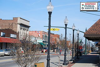
Bedford is a city in Cuyahoga County, Ohio, United States. The population was 13,149 at the 2020 census. It is an eastern suburb of Cleveland.
Euclid is a city in Cuyahoga County, Ohio, United States. Located on the southern shore of Lake Erie, it is an inner ring suburb of Cleveland. The population was 49,692 at the 2020 census, making it the fourth largest city in Cuyahoga County.
Lakewood is a city in Cuyahoga County, Ohio, United States, on the southern shore of Lake Erie. Established in 1889, it is one of Cleveland's historical streetcar suburbs and part of the Cleveland metropolitan area. The population was 50,942 at the 2020 census, making it the third largest city in Cuyahoga County, behind Cleveland and Parma.
Huron is a city in Erie County, Ohio, United States, located at the mouth of the Huron River on Lake Erie. The population was 6,922 at the 2020 census. It is part of the Sandusky micropolitan area.
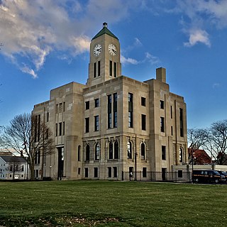
Chardon is a city in and the county seat of Geauga County, Ohio, United States. The population was 5,242 at the 2020 census. It is the only incorporated city in Geauga County, and includes land that was once part of Chardon, Hambden and Munson townships. It is located about 10 miles south of Lake Erie and within the "snow belt" of the Great Lakes and is part of the Cleveland metropolitan area.
Avon Lake is a city in northeastern Lorain County, Ohio, United States, located on the southern shore of Lake Erie about 17 miles (27 km) west of Cleveland. The population was 25,206 at the 2020 census. It is part of the Cleveland metropolitan area.
Lorain is a city in Lorain County, Ohio, United States. It is located in Northeast Ohio on Lake Erie at the mouth of the Black River, about 25 miles (40 km) west of Cleveland. As of the 2020 census, the city had a population of 65,211, making it Ohio's ninth-largest city, the third-largest in Greater Cleveland, and the largest in Lorain County by population.
Aurora is a city in northwestern Portage County, Ohio, United States. A suburb in between Akron and Cleveland, the population was 17,239 at the 2020 census. It is part of the Akron metropolitan area.
Stow is a city in Summit County, Ohio, United States. The population was 34,483 at the 2020 census. It is a suburban community within the Akron metropolitan area.
The Cleveland metropolitan area, or Greater Cleveland as it is more commonly known, is the metropolitan area surrounding the city of Cleveland in Northeast Ohio, United States. According to the 2020 census results, the six-county Cleveland, OH Metropolitan Statistical Area (MSA) consists of Cuyahoga County, Ashtabula County, Geauga County, Lake County, Lorain County, and Medina County, and has a population of 2,185,825, making it the 33rd-most populous metropolitan area in the United States and the third largest metropolitan area in Ohio. The metro area is also part of the larger Cleveland–Akron–Canton Combined Statistical Area with a population of over 3.7 million people, the most populous statistical area in Ohio and the 17th most populous in the United States.
The region Northeast Ohio, in the US state of Ohio, in its most expansive usage contains six metropolitan statistical areas: Cleveland–Elyria, Akron, Canton–Massillon, Youngstown–Warren, Mansfield, and Weirton–Steubenville along with eight micropolitan statistical areas. Most of the region is considered either part of the Cleveland–Akron–Canton, OH Combined Statistical Area and media market or the Youngstown–Warren, OH–PA Combined Statistical Area and media market. In all, the region is home to: 4,502,460 residents. It is also a part of the Great Lakes megalopolis, containing over 54 million people. Northeast Ohio also includes most of the area known historically as the Connecticut Western Reserve.
Greater Pittsburgh is the metropolitan area surrounding the city of Pittsburgh in Western Pennsylvania, United States. The region includes Allegheny County, Pittsburgh's urban core county and economic hub, and seven adjacent Pennsylvania counties: Armstrong, Beaver, Butler, Fayette, Lawrence, Washington, and Westmoreland in Western Pennsylvania, which constitutes the Pittsburgh, PA Metropolitan Statistical Area MSA as defined by the U.S. Census Bureau.
Concord Township is one of the five townships of Lake County, Ohio, United States. As of the 2020 census, the population was 19,254. Lake County is part of the Cleveland-Elyria, OH Metropolitan Statistical Area.
Painesville Township is one of the five townships of Lake County, Ohio, United States. The population was 20,453 at the 2020 census. It is a part of Greater Cleveland in the Northeast Ohio Region, and is included in the Cleveland-Akron-Canton, Ohio combined statistical area in the United States.
Sandusky is a city in and the county seat of Erie County, Ohio, United States. Situated along the southern shore of Lake Erie, Sandusky is located roughly midway between Toledo and Cleveland. According to 2020 census, the city had a population of 25,095, and the Sandusky metropolitan area had 115,986 residents.