Perry, Ohio

Last updated

Perry, Ohio
Lucius Green House.jpg
The Lucius Green House, built 1880
Motto: 
"Together We Take Pride"
OHMap-doton-Perry.png
Location of Perry, Ohio
Map of Lake County Ohio Highlighting Perry Village.png
Location of Perry in Lake County
Coordinates: 41°45′33″N81°8′18″W / 41.75917°N 81.13833°W / 41.75917; -81.13833
Country United States
State Ohio
County Lake
Township Perry
Government
  Type Mayor–council government
   Mayor Jim Gessic
Area
[1]
  Total2.27 sq mi (5.88 km2)
  Land2.27 sq mi (5.88 km2)
  Water0.00 sq mi (0.00 km2)
Elevation
[2]
699 ft (213 m)
Population
 (2020)
  Total1,602
  Density705.73/sq mi (272.50/km2)
Time zone UTC-5 (Eastern (EST))
  Summer (DST) UTC-4 (EDT)
ZIP code
44081
Area code 440
FIPS code 39-61882 [3]
GNIS feature ID1044385 [2]
Website perryvillageohio.com

Perry is a village in Lake County, Ohio, United States. The population was 1,602 at the 2020 census.

Contents

History

Commodore Oliver Hazard Perry Oliver Hazard Perry 01.jpg
Commodore Oliver Hazard Perry

It is named in honor of Commodore Oliver Hazard Perry to commemorate his victory over the British fleet at the Battle of Lake Erie in September 1813. [4] The battle was a turning point in the western theater during the War of 1812. Perry is known for its public schools, whose recent construction was influenced by the nearby Perry Nuclear Generating Station.

Geography

Perry is located at 41°45′33″N81°8′18″W / 41.75917°N 81.13833°W / 41.75917; -81.13833 (41.759121, -81.138321). [5]

According to the United States Census Bureau, the village has a total area of 2.18 square miles (5.65 km2), all land. [6]

Demographics

Historical population
CensusPop.Note
1880 170
1920 473
1930 60227.3%
1940 6457.1%
1950 6653.1%
1960 88533.1%
1970 9173.6%
1980 9614.8%
1990 1,0125.3%
2000 1,19518.1%
2010 1,66339.2%
2020 1,602−3.7%
U.S. Decennial Census [7]

2010 census

As of the census [8] of 2010, there were 1,663 people, 593 households, and 456 families living in the village. The population density was 762.8 inhabitants per square mile (294.5/km2). There were 630 housing units at an average density of 289.0 per square mile (111.6/km2). The racial makeup of the village was 96.1% White, 0.8% African American, 1.4% Asian, 0.6% from other races, and 1.1% from two or more races. Hispanic or Latino of any race were 2.6% of the population.

There were 593 households, of which 40.3% had children under the age of 18 living with them, 60.7% were married couples living together, 12.0% had a female householder with no husband present, 4.2% had a male householder with no wife present, and 23.1% were non-families. 20.4% of all households were made up of individuals, and 8.5% had someone living alone who was 65 years of age or older. The average household size was 2.78 and the average family size was 3.21.

The median age in the village was 39.9 years. 28.8% of residents were under the age of 18; 6.7% were between the ages of 18 and 24; 23.8% were from 25 to 44; 30.2% were from 45 to 64; and 10.6% were 65 years of age or older. The gender makeup of the village was 49.6% male and 50.4% female.

2000 census

As of the census [3] of 2000, there were 1,195 people, 426 households, and 325 families living in the village. The population density was 548.2 inhabitants per square mile (211.7/km2). There were 438 housing units at an average density of 200.9 per square mile (77.6/km2). The racial makeup of the village was 98.41% White, 0.08% African American, 0.17% Native American, 0.67% Asian, 0.25% from other races, and 0.42% from two or more races. Hispanic or Latino of any race were 0.42% of the population. 20.7% were of German, 16.0% Italian, 12.9% English, 10.5% Irish and 6.0% American ancestry according to Census 2000.

There were 426 households, out of which 42.0% had children under the age of 18 living with them, 64.1% were married couples living together, 8.7% had a female householder with no husband present, and 23.7% were non-families. 20.0% of all households were made up of individuals, and 7.5% had someone living alone who was 65 years of age or older. The average household size was 2.81 and the average family size was 3.24.

In the village, the population was spread out, with 30.3% under the age of 18, 6.2% from 18 to 24, 29.9% from 25 to 44, 24.5% from 45 to 64, and 9.1% who were 65 years of age or older. The median age was 38 years. For every 100 females there were 94.3 males. For every 100 females age 18 and over, there were 91.9 males.

The median income for a household in the village was $52,955, and the median income for a family was $58,281. Males had a median income of $41,898 versus $28,672 for females. The per capita income for the village was $22,078. About 1.5% of families and 2.7% of the population were below the poverty line, including 2.6% of those under age 18 and 1.9% of those age 65 or over.

Government

Perry village has an elected mayor and council form of government.

Perry is served by the Perry Public Schools.

In 2005, the Perry Public Library loaned more than 245,000 items to its 8,000 cardholders. Total holdings are over 52,000 volumes with over 275 periodical subscriptions. [9]

Notable people

Related Research Articles

<span class="mw-page-title-main">Plainfield, Ohio</span> Village in Ohio, United States

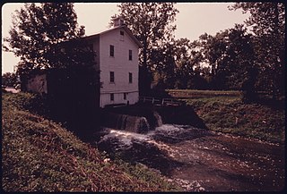
Plainfield is a village in Coshocton County, Ohio, United States, along Wills Creek. The population was 141 at the 2020 census.

<span class="mw-page-title-main">Bentleyville, Ohio</span> Village in Ohio, United States

Bentleyville is a village in Cuyahoga County, Ohio, United States. The population was 897 at the 2020 census. A suburb of Cleveland, it is a part of the Cleveland metropolitan area.

<span class="mw-page-title-main">Cuyahoga Heights, Ohio</span> Village in Ohio, United States

Cuyahoga Heights is a village in Cuyahoga County, Ohio, United States. The population was 573 at the 2020 census. A suburb of Cleveland, it is a part of the Cleveland metropolitan area.

<span class="mw-page-title-main">Highland Hills, Ohio</span> Village in Ohio, United States

Highland Hills is a village in Cuyahoga County, Ohio, United States. The population was 662 at the 2020 census. A suburb of Cleveland, it was formally incorporated in 1990.

<span class="mw-page-title-main">Oakwood, Cuyahoga County, Ohio</span> Village in Ohio, United States

Oakwood is a village in Cuyahoga County, Ohio, United States. The population was 3,572 at the 2020 census. An inner ring suburb of Cleveland, it is a part of the Cleveland metropolitan area.

<span class="mw-page-title-main">Valley View, Ohio</span> Village in Ohio, United States

Valley View is a village in Cuyahoga County, Ohio, United States. The population was 1,897 at the 2020 census. A suburb of Cleveland, it is a part of the Cleveland metropolitan area.

<span class="mw-page-title-main">Walton Hills, Ohio</span> Village in Ohio, United States

Walton Hills is a village in Cuyahoga County, Ohio, United States. The population was 2,033 at the 2020 census. A suburb of Cleveland, it is a part of the Cleveland metropolitan area.

<span class="mw-page-title-main">Woodmere, Ohio</span> Village in Ohio, United States

Woodmere is a village in Cuyahoga County, Ohio, United States. As of the 2020 census, Woodmere had a population of 641 residents. An eastern suburb of Cleveland, it is part of the Cleveland metropolitan area.

<span class="mw-page-title-main">Addyston, Ohio</span> Village in Ohio, United States

Addyston is a village in Miami Township, Hamilton County, Ohio, United States. Located along the Ohio River, it is a western suburb of the neighboring city of Cincinnati. The population was 927 at the 2020 census.

<span class="mw-page-title-main">Van Buren, Ohio</span> Village in Ohio, United States

Van Buren is a village in Hancock County, Ohio, United States. The population was 396 at the 2020 census.

<span class="mw-page-title-main">Grand River, Ohio</span> Village in Ohio, United States

Grand River is a village in Lake County, Ohio, United States, along the Grand River. The population was 394 at the 2020 census.

<span class="mw-page-title-main">Madison, Ohio</span> Village in Ohio, United States

Madison is a village in Lake County, Ohio, United States. The population was 3,435 at the 2020 census.

<span class="mw-page-title-main">North Perry, Ohio</span> Village in Ohio, United States

North Perry is a village in Lake County, Ohio, United States. The population was 915 at the 2020 census.

<span class="mw-page-title-main">Timberlake, Ohio</span> Village in Ohio, United States

Timberlake is a village in Lake County, Ohio, United States. The population was 629 at the 2020 census.

<span class="mw-page-title-main">Gloria Glens Park, Ohio</span> Village in Ohio, United States

Gloria Glens Park is a village in Medina County, Ohio, United States. The population was 369 at the 2020 census.

<span class="mw-page-title-main">Westfield Center, Ohio</span> Village in Ohio, United States

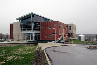
Westfield Center is a village in Medina County, Ohio, United States. The population was 1,184 at the 2020 census. It is the home of Westfield Insurance, the largest employer in Medina County.

<span class="mw-page-title-main">Norwich, Ohio</span> Village in Ohio, United States

Norwich is a village in Muskingum County, Ohio, United States. The population was 87 at the 2020 census. It is part of the Zanesville micropolitan area.

<span class="mw-page-title-main">Junction City, Ohio</span> Village in Ohio, United States

Junction City is a village in Perry County, Ohio, United States. The population was 721 at the 2020 census.

<span class="mw-page-title-main">Boston Heights, Ohio</span> Village in Ohio, United States

Boston Heights is a village in northern Summit County, Ohio, United States. The population was 1,402 at the 2020 census. It is part of the Akron metropolitan area. Boston Heights is home to the headquarters of Arhaus, a major home furnishings retailer.

<span class="mw-page-title-main">Wilson, Ohio</span> Village in Ohio, United States

Wilson is a village in Belmont and Monroe counties in the U.S. state of Ohio. The population was 129 at the 2020 census. It is part of the Wheeling metropolitan area.

References

  1. "ArcGIS REST Services Directory". United States Census Bureau. Retrieved September 20, 2022.
  2. 1 2 "US Board on Geographic Names". United States Geological Survey. October 25, 2007. Retrieved January 31, 2008.
  3. 1 2 "U.S. Census website". United States Census Bureau . Retrieved January 31, 2008.
  4. Overman, William Daniel (1958). Ohio Town Names. Akron, OH: Atlantic Press. p. 109.
  5. "US Gazetteer files: 2010, 2000, and 1990". United States Census Bureau. February 12, 2011. Retrieved April 23, 2011.
  6. "U.S. Gazetteer Files: 2019: Places: Ohio". U.S. Census Bureau Geography Division. Retrieved July 1, 2020.
  7. "Census of Population and Housing". Census.gov. Retrieved June 4, 2015.
  8. "U.S. Census website". United States Census Bureau . Retrieved January 6, 2013.
  9. "2005 Ohio Public Library Statistics:Statistics by County and Town". State Library of Ohio. Archived from the original on September 24, 2006. Retrieved November 6, 2006.