Kirtland Hills, Ohio

Last updated

Kirtland Hills, Ohio
Leonard C. Hanna, Jr., Estate great house.jpg
Estate of Leonard C. Hanna Jr.
OHMap-doton-Kirtland Hills.png
Location of Kirtland Hills, Ohio
Map of Lake County Ohio Highlighting Kirtland Hills Village.png
Location of Kirtland Hills in Lake County
Coordinates: 41°37′43″N81°18′45″W / 41.62861°N 81.31250°W / 41.62861; -81.31250
Country United States
State Ohio
County Lake
Area
[1]
  Total5.65 sq mi (14.63 km2)
  Land5.57 sq mi (14.43 km2)
  Water0.08 sq mi (0.20 km2)
Elevation
[2]
712 ft (217 m)
Population
 (2020)
  Total692
  Density124.21/sq mi (47.96/km2)
Time zone UTC-5 (Eastern (EST))
  Summer (DST) UTC-4 (EDT)
ZIP codes
44060, 44094
Area code 440
FIPS code 39-40670 [3]
GNIS feature ID1086420 [2]
Website https://www.kirtlandhills.org/

Kirtland Hills is a village in Lake County, Ohio, United States and a rural suburb of Cleveland. The population was 692 at the 2020 census.

Contents

Geography

According to the United States Census Bureau, the village has a total area of 5.65 square miles (14.63 km2), of which 5.57 square miles (14.43 km2) is land and 0.08 square miles (0.21 km2) is water. [4]

Demographics

Historical population
CensusPop.Note
1930 206
1940 23715.0%
1950 235−0.8%
1960 29224.3%
1970 45254.8%
1980 50611.9%
1990 62824.1%
2000 597−4.9%
2010 6468.2%
2020 6927.1%
U.S. Decennial Census [5]

2010 census

As of the census [6] of 2010, there were 646 people, 245 households, and 200 families living in the village. The population density was 116.0 inhabitants per square mile (44.8/km2). There were 272 housing units at an average density of 48.8 per square mile (18.8/km2). The racial makeup of the village was 96.7% White, 1.7% Asian, and 1.5% from two or more races. Hispanic or Latino of any race were 2.8% of the population.

There were 245 households, of which 29.4% had children under the age of 18 living with them, 71.4% were married couples living together, 4.5% had a female householder with no husband present, 5.7% had a male householder with no wife present, and 18.4% were non-families. 14.7% of all households were made up of individuals, and 9.7% had someone living alone who was 65 years of age or older. The average household size was 2.64 and the average family size was 2.93.

The median age in the village was 48 years. 22.4% of residents were under the age of 18; 5.4% were between the ages of 18 and 24; 15.4% were from 25 to 44; 37.7% were from 45 to 64; and 19.2% were 65 years of age or older. The gender makeup of the village was 48.6% male and 51.4% female.

2000 census

As of the census [3] of 2000, there were 597 people, 223 households, and 179 families living in the village. The population density was 106.9 inhabitants per square mile (41.3/km2). There were 242 housing units at an average density of 43.3 per square mile (16.7/km2). The racial makeup of the village was 98.16% White, 0.34% African American, 0.17% Asian, and 1.34% from two or more races. Hispanic or Latino of any race were 0.50% of the population. 17.7% were of Italian, 16.8% German, 12.5% Irish, 8.4% English, 5.4% American, 5.4% Slovene and 5.0% Hungarian ancestry according to Census 2000.

There were 223 households, out of which 29.6% had children under the age of 18 living with them, 74.0% were married couples living together, 4.9% had a female householder with no husband present, and 19.3% were non-families. 14.8% of all households were made up of individuals, and 6.3% had someone living alone who was 65 years of age or older. The average household size was 2.68 and the average family size was 2.99.

In the village, the population was spread out, with 24.0% under the age of 18, 3.9% from 18 to 24, 22.6% from 25 to 44, 36.5% from 45 to 64, and 13.1% who were 65 years of age or older. The median age was 45 years. For every 100 females there were 92.6 males. For every 100 females age 18 and over, there were 99.1 males.

The median income for a household in the village was $112,421, and the median income for a family was $144,134. Males had a median income of $87,424 versus $37,083 for females. The per capita income for the village was $78,896. About 2.1% of families and 3.2% of the population were below the poverty line, including none of those under age 18 and 4.3% of those age 65 or over.

Education

Kirtland Hills is split between Mentor Public Schools [7] (Northern portions of Village) and Kirtland Local Schools (Southern portions of Village.) [8]

Most students in Mentor Schools are zoned to Hopkins Elementary School while a portion is in the boundary of Brentmoor Elementary School. [9] Most students in the section are zoned to Memorial Middle School. [10] All students in the Mentor school district are zoned to Mentor High School.

Nearby private schools include Andrews Osborne Academy.

Parks and conservation

Kirtland Hills is home to a number of parks and conservation spaces:

Related Research Articles

<span class="mw-page-title-main">Poland, Ohio</span> Village in Ohio, United States

Poland is a village in eastern Mahoning County, Ohio, United States. The population was 2,463 at the 2020 census. A suburb about 7 miles (11 km) south of Youngstown, it is part of the Youngstown–Warren metropolitan area.

<span class="mw-page-title-main">Deep River, Connecticut</span> Town in Connecticut, United States

Deep River is a town in Middlesex County, Connecticut. The town is part of the Lower Connecticut River Valley Planning Region. The population was 4,415 at the 2020 census. The town center is designated by the U.S. Census Bureau as a census-designated place (CDP). Deep River is part of what the locals call the "Tri-town Area", made up of the towns of Deep River, Chester, and Essex.

<span class="mw-page-title-main">Mattawan, Michigan</span> Village in Michigan, United States

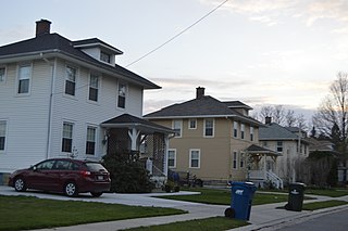
Mattawan is a village in Antwerp Township, Van Buren County of the U.S. state of Michigan. The population was 1,997 at the 2010 census.

<span class="mw-page-title-main">Boys Town, Nebraska</span> Village in Douglas County, Nebraska, United States

Boys Town is a village in Douglas County, Nebraska, United States. The population was 410 at the 2020 census. Boys Town is an enclave and a suburb of Omaha.

<span class="mw-page-title-main">Kirtland, New Mexico</span> Town in New Mexico, United States

Kirtland is a town, made up of part of the former census-designated place (CDP) of the same name in San Juan County, New Mexico, United States. The population of the former CDP was 6,190 at the 2000 census. It is part of the Farmington Metropolitan Statistical Area.

<span class="mw-page-title-main">Mowrystown, Ohio</span> Village in Ohio, United States

Mowrystown is a village in Highland County, Ohio, United States. The population was 385 at the 2020 census.

<span class="mw-page-title-main">Mentor-on-the-Lake, Ohio</span> City in Ohio, United States

Mentor-on-the-Lake is a city in Lake County, Ohio, United States. The population was 7,131 at the 2020 census.

<span class="mw-page-title-main">Willoughby Hills, Ohio</span> City in Ohio, United States

Willoughby Hills is a city in Lake County, Ohio, United States, along the Chagrin River. The population was 10,019 at the 2020 census. A suburb of Cleveland, it is part of the Cleveland metropolitan area.

<span class="mw-page-title-main">Hebron, Ohio</span> Village in Ohio, USA

Hebron is a village in Licking County, Ohio, United States. The population was 2,326 at the 2020 census.

<span class="mw-page-title-main">Johnstown, Ohio</span> City in Ohio, United States

Johnstown is a city in Licking County, Ohio, United States. The population was 5,182 at the 2020 census.

<span class="mw-page-title-main">South Amherst, Ohio</span> Village in Ohio, United States

South Amherst is a village in Lorain County, Ohio, United States. The population was 1,581 at the 2020 census.

<span class="mw-page-title-main">Syracuse, Ohio</span> Village in Ohio, United States

Syracuse is a village in Meigs County, Ohio, United States, along the Ohio River. The population was 781 at the 2020 census.

<span class="mw-page-title-main">Thornville, Ohio</span> Village in Ohio, United States

Thornville is a village in Perry County, Ohio, United States. It is 20 miles (32 km) north of the county seat of New Lexington. The village had a population of 1,087 as of the 2020 census.

<span class="mw-page-title-main">Kingston, Ohio</span> Village in Ohio, United States

Kingston is a village in Ross County, Ohio, United States. The population was 1,262 at the 2020 census.

<span class="mw-page-title-main">Smithville, Ohio</span> Village in Ohio, United States

Smithville is a village in Wayne County, Ohio, United States. The population was 1,338 at the time of the 2020 census. The village derives its name from Thomas Smith, a pioneer settler.

<span class="mw-page-title-main">Kekoskee, Wisconsin</span> Village in Wisconsin, United States

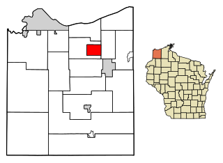
Kekoskee is a village in Dodge County, Wisconsin, United States. The population was 161 at the 2010 census.

<span class="mw-page-title-main">Poplar, Wisconsin</span> Village in Wisconsin, United States

Poplar is a village in Douglas County, Wisconsin, United States. The population was 603 at the 2010 census.

Sunrise Beach is a village in Camden and Morgan counties in the U.S. state of Missouri. The population was 431 at the 2010 census.

<span class="mw-page-title-main">Lynchburg, Ohio</span> Village in Ohio, United States

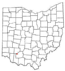
Lynchburg is a village in Clinton and Highland counties in the U.S. state of Ohio. The population was 1,510 at the 2020 census.

<span class="mw-page-title-main">Verona, Ohio</span> Village in Ohio, United States

Verona is a village in Montgomery and Preble counties in the U.S. state of Ohio. The population was 403 at the 2020 census. It is part of the Dayton Metropolitan Statistical Area.

References

  1. "ArcGIS REST Services Directory". United States Census Bureau. Retrieved September 20, 2022.
  2. 1 2 U.S. Geological Survey Geographic Names Information System: Kirtland Hills, Ohio
  3. 1 2 "U.S. Census website". United States Census Bureau . Retrieved January 31, 2008.
  4. "US Gazetteer files 2010". United States Census Bureau. Archived from the original on January 25, 2012. Retrieved January 6, 2013.
  5. "Census of Population and Housing". Census.gov. Retrieved June 4, 2015.
  6. "U.S. Census website". United States Census Bureau . Retrieved January 6, 2013.
  7. "About Our District Archived 2019-12-29 at the Wayback Machine ." Mentor Public Schools. Retrieved on June 1, 2017.
  8. "Lake County GIS Website".
  9. "2015 Elementary School Attendance Areas Archived 2017-05-31 at the Wayback Machine ." Mentor Public Schools. Retrieved on June 1, 2017.
  10. 2015 Middle School Attendance Areas Archived 2017-05-31 at the Wayback Machine ." Mentor Public Schools. Retrieved on June 1, 2017.