Washington Court House, Ohio

Last updated

Washington Court House, Ohio
Downtown Washington Court House from the courthouse lawn.jpg
Downtown Washington Court House from the courthouse lawn
WCHseal.jpg
Nickname: 
Washington C.H.
Map of Fayette County Ohio Highlighting Washington Court House City.png
Location of Washington Court House in Fayette County
USA Ohio relief location map.svg
Red pog.svg
Washington Court House
Usa edcp relief location map.png
Red pog.svg
Washington Court House
Coordinates: 39°32′17″N83°25′41″W / 39.53806°N 83.42806°W / 39.53806; -83.42806 [1]
CountryUnited States
State Ohio
County Fayette
Township Union
Area
[2]
  Total8.98 sq mi (23.27 km2)
  Land8.92 sq mi (23.11 km2)
  Water0.06 sq mi (0.16 km2)
Elevation
[1]
965 ft (294 m)
Population
 (2020)
  Total14,401
  Density1,613.74/sq mi (623.05/km2)
Time zone UTC−5 (Eastern (EST))
  Summer (DST) UTC−4 (EDT)
ZIP code
43160
Area code 740
FIPS code 39-81214 [3]
GNIS feature ID1086095 [1]
Website http://www.cityofwch.com/

Washington Court House (often abbreviated as Washington C.H.) is a city in Union Township, Fayette County, Ohio. It is the county seat of Fayette County and is located between Cincinnati and Columbus. The population grew almost 1.5% from 2010 to 2020 approaching 14,401 people according to the 2020 census results. [4] The area was initially settled by Virginia veterans of the American Revolution, who received the land from the government as payment for their service in the war. [5]

Contents

Name

Officially named Washington as far back as 1910, the "Court House" suffix was used to distinguish the city from other places in the state with "Washington" in their name (Ohio also has an Old Washington, New Washington, Washingtonville, and Port Washington). [6] The suffix is attributed to settlers who had come from Virginia, where "Court House" was used with county seats (e.g. Appomattox Court House). [6] "Washington C. H." was added to maps and postal guides, and the de facto use of "Washington Court House" persisted over time. [6] The name was made official when the city adopted a new charter in the early 2000s. [lower-alpha 1] "Washington Court House" is the longest city name in the state of Ohio. [8]

History

Washington Court House's first settlers appear to have been Edward Smith Sr., and his family, who emigrated from Pennsylvania in 1810. Smith and his family constructed a crude house in the thick woodlands near Paint Creek, but their efforts to clear the land were interrupted by his departure for military service in the War of 1812. [9] Comparatively soon after returning from his martial pursuits, Smith drowned while attempting to cross a flooded creek, [10] but his widow and 10 children survived and prospered despite the absence of their patriarch. Smith's descendants remained prominent in Fayette County for more than a century after his arrival from Pennsylvania, although many had left Washington Court House for other parts of the county. [9] A family residence still stands on U.S. Route 62 not far outside the city's eastern boundary. [11]

In 1833, Washington Court House (then known as Washington) contained a printing office, seven stores, two taverns, two groceries, a schoolhouse, a meeting house, and about 70 residential houses. [12]

Numerous locations in the city are listed on the National Register of Historic Places. Downtown, the courthouse square has been named a historic district, and a similar designation has been accorded the city cemetery. Nine individual buildings are separately listed on the register: Judy Chapel at the cemetery, the former Washington School, the Fayette County Courthouse, the former William Burnett House (no longer standing [13] ), and the Barney Kelley, Jacob Light, Rawlings-Brownell, Robinson-Pavey, and Morris Sharp houses. [11]

Streets within the downtown part of the city around the courthouse building are arranged northeast–southwest and northwest–southeast, rather than east–west and north–south, so that each side of the courthouse receives some sunlight every day of the year. [5]

1894 riot

Ohio Historical Marker on the front lawn of the Fayette County Courthouse WCHRiot.JPG
Ohio Historical Marker on the front lawn of the Fayette County Courthouse

On October 16, 1894, a crowd gathered outside the Fayette County Courthouse with intent to lynch William "Jasper" Dolby, a black man who had been convicted of sexually assaulting a white woman. Ohio Governor William McKinley called out the militia to subdue the crowd. On October 17, the crowd rushed the courthouse doors and was warned to "disperse or be fired upon." They ignored the warning and continued to batter the doors.

Colonel Alonzo B. Coit ordered his troops to fire through the courthouse doors, killing five men. Colonel Coit was indicted for manslaughter, but was acquitted at trial. After the trial, Governor McKinley stated, "The law was upheld as it should have been... but in this case at fearful cost... Lynching cannot be tolerated in Ohio." [14] The courthouse doors were not repaired or replaced and the bullet holes from the 1894 riot are still present in the southeast doors. [15]

Geography

Washington Court House is located along Paint Creek.

According to the United States Census Bureau, the city has a total area of 8.80 square miles (22.79 km2), of which 8.74 square miles (22.64 km2) is land and 0.06 square miles (0.16 km2) is covered by water. [16]

Climate

Climate data for Washington Court House, Ohio, 1991–2020 normals, extremes 1915present
MonthJanFebMarAprMayJunJulAugSepOctNovDecYear
Record high °F (°C)74
(23)
77
(25)
87
(31)
89
(32)
95
(35)
101
(38)
107
(42)
103
(39)
102
(39)
92
(33)
81
(27)
77
(25)
107
(42)
Mean maximum °F (°C)60.9
(16.1)
64.3
(17.9)
73.4
(23.0)
79.6
(26.4)
85.9
(29.9)
90.5
(32.5)
91.8
(33.2)
90.9
(32.7)
89.1
(31.7)
82.9
(28.3)
70.3
(21.3)
63.2
(17.3)
93.1
(33.9)
Mean daily maximum °F (°C)36.0
(2.2)
39.9
(4.4)
50.2
(10.1)
63.8
(17.7)
73.0
(22.8)
80.7
(27.1)
83.5
(28.6)
82.3
(27.9)
77.2
(25.1)
65.7
(18.7)
51.8
(11.0)
40.7
(4.8)
62.1
(16.7)
Daily mean °F (°C)27.8
(−2.3)
30.9
(−0.6)
39.9
(4.4)
51.6
(10.9)
61.8
(16.6)
70.1
(21.2)
73.2
(22.9)
71.7
(22.1)
65.5
(18.6)
54.0
(12.2)
41.9
(5.5)
32.9
(0.5)
51.8
(11.0)
Mean daily minimum °F (°C)19.6
(−6.9)
21.9
(−5.6)
29.6
(−1.3)
39.5
(4.2)
50.5
(10.3)
59.6
(15.3)
62.9
(17.2)
61.1
(16.2)
53.9
(12.2)
42.3
(5.7)
31.9
(−0.1)
25.1
(−3.8)
41.5
(5.3)
Mean minimum °F (°C)0.4
(−17.6)
4.1
(−15.5)
12.7
(−10.7)
25.3
(−3.7)
36.9
(2.7)
48.0
(8.9)
54.3
(12.4)
52.0
(11.1)
40.6
(4.8)
29.6
(−1.3)
18.3
(−7.6)
8.9
(−12.8)
−3.4
(−19.7)
Record low °F (°C)−27
(−33)
−14
(−26)
−6
(−21)
16
(−9)
26
(−3)
37
(3)
44
(7)
37
(3)
28
(−2)
15
(−9)
−6
(−21)
−20
(−29)
−27
(−33)
Average precipitation inches (mm)3.01
(76)
2.53
(64)
3.76
(96)
4.06
(103)
4.45
(113)
4.33
(110)
3.95
(100)
3.35
(85)
2.69
(68)
2.69
(68)
2.78
(71)
3.19
(81)
40.79
(1,035)
Average snowfall inches (cm)7.9
(20)
3.7
(9.4)
2.8
(7.1)
0.3
(0.76)
0.0
(0.0)
0.0
(0.0)
0.0
(0.0)
0.0
(0.0)
0.0
(0.0)
0.2
(0.51)
0.7
(1.8)
2.7
(6.9)
18.3
(46.47)
Average precipitation days (≥ 0.01 in)11.710.311.613.013.211.510.78.28.19.610.611.1129.6
Average snowy days (≥ 0.1 in)3.82.31.50.30.00.00.00.00.00.10.62.110.7
Source 1: NOAA [17]
Source 2: National Weather Service [18]

Demographics

Historical population
CensusPop.Note
1820 191
1830 29956.5%
1850 569
1860 1,03581.9%
1870 2,117104.5%
1880 3,79879.4%
1890 5,74251.2%
1900 5,7510.2%
1910 7,27726.5%
1920 7,9629.4%
1930 8,4265.8%
1940 9,40211.6%
1950 10,56012.3%
1960 12,38817.3%
1970 12,4950.9%
1980 12,6481.2%
1990 12,9832.6%
2000 13,5244.2%
2010 14,1924.9%
2020 14,4011.5%
2021 (est.)14,4960.7%
Sources: [3] [19] [20] [21]

2010 census

As of the census [22] of 2010, there were 14,192 people, 5,762 households, and 3,628 families residing in the city. The population density was 1,623.8 inhabitants per square mile (627.0/km2). There were 6,433 housing units at an average density of 736.0 per square mile (284.2/km2). The racial makeup of the city was 93.5% White, 2.7% African American, 0.3% Native American, 0.8% Asian, 0.6% from other races, and 2.1% from two or more races. Hispanic or Latino of any race were 1.8% of the population.

There were 5,762 households, of which 32.8% had children under the age of 18 living with them, 40.7% were married couples living together, 16.6% had a female householder with no husband present, 5.7% had a male householder with no wife present, and 37.0% were non-families. 31.1% of all households were made up of individuals, and 12.7% had someone living alone who was 65 years of age or older. The average household size was 2.37 and the average family size was 2.92.

The median age in the city was 38.4 years. 25% of residents were under the age of 18; 8.1% were between the ages of 18 and 24; 25.7% were from 25 to 44; 25.2% were from 45 to 64; and 15.9% were 65 years of age or older. The gender makeup of the city was 47.7% male and 52.3% female.

2000 census

As of the census [3] of 2000, there were 13,524 people, 5,483 households, and 3,536 families residing in the city. The population density was 810.8/km2 (2,100.8/mi2). There were 5,961 housing units at an average density of 357.4/km2 (926.0/mi2). The racial makeup of the city was 94.52% White, 2.71% African American, 0.16% Native American, 0.82% Asian, 0.01% Pacific Islander, 0.66% from other races, and 1.12% from two or more races. Hispanic or Latino of any race were 1.38% of the population.

There were 5,483 households, out of which 31.1% had children under the age of 18 living with them, 46.5% were married couples living together, 13.7% had a female householder with no husband present, and 35.5% were non-families. 30.7% of all households were made up of individuals, and 14.2% had someone living alone who was 65 years of age or older. The average household size was 2.37 and the average family size was 2.93.

In the city the age distribution of the population showed 25.0% under the age of 18, 8.1% from 18 to 24, 28.2% from 25 to 44, 22.0% from 45 to 64, and 16.7% who were 65 years of age or older. The median age was 37 years. For every 100 females, there were 92.7 males. For every 100 females age 18 and over, there were 87.0 males.

The median income for a household in the city was $33,003, and the median income for a family was $40,721. Males had a median income of $31,708 versus $22,382 for females. The per capita income for the city was $18,618. About 9.0% of families and 12.5% of the population were below the poverty line, including 16.3% of those under the age of 18 and 13.2% ages 65 or older.

Media

Washington Court House is part of the Columbus, Ohio, media market, so is served by several Columbus-area television and radio stations. [23] The city has two local radio stations. Buckeye Country 105.5 FM (WCHO-FM) WCHO plays country music and (WCHO-AM) 1250 plays oldies. Both stations cover local news, sports, and agricultural stories. Washington Court House also easily receives radio and television stations from Dayton and Cincinnati.

The hometown newspaper of Washington Court House is the Record Herald . The Record Herald was formed from the merger of two dailies – The Record-Republican and the Washington C.H. Herald – in 1937. [24] The latter paper's publishing history dates back to 1858 when it began as a weekly. [25] As of 2012, the Record Herald reported circulation of 5,143 daily and 21,849 for weekend inserts. [26]

Notable people

Education

Education in Washington Court House, Ohio, comprises two public school districts, as well as a private school .


Washington Court House has a public library, housed in a historic Carnegie library building. [27]

Airport

Fayette County Airport is a county-owned general aviation facility located northeast of Washington Court House.

See also

Notes

  1. The city's website gives a 2002 date for the charter change that formally adopted the Washington Court House name; [5] however, the charter itself cites an effective date of January 1, 2004. [7]

Related Research Articles

<span class="mw-page-title-main">Clinton County, Ohio</span> County in Ohio, United States

Clinton County is a county located in the U.S. state of Ohio. As of the 2020 census, the population was 42,018. Its county seat and largest city is Wilmington. The county is named for former U.S. Vice President George Clinton. Clinton County comprises the Wilmington, Ohio Micropolitan Statistical Area, which is also included in the Cincinnati-Wilmington-Maysville, OH-KY-IN Combined Statistical Area.

<span class="mw-page-title-main">Marion County, Alabama</span> County in Alabama, United States

Marion County is a county of the U.S. state of Alabama. As of the 2020 census the population was 29,341. The county seat is Hamilton. The county was created by an act of the Alabama Territorial General Assembly on February 13, 1818. The county seat was originally established in Pikeville in 1820, and moved to Hamilton in 1881. The county was named by planter and US Indian agent John Dabney Terrell, Sr., in recognition of General Francis Marion of South Carolina.

<span class="mw-page-title-main">Highland County, Ohio</span> County in Ohio, United States

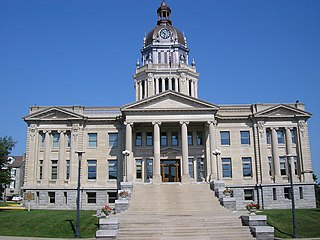
Highland County is a county located in the U.S. state of Ohio. As of the 2020 census, the population was 43,317. Its county seat is Hillsboro. The county is named for the topography which is hilly and divides the watersheds of the Little Miami and Scioto Rivers.

<span class="mw-page-title-main">Fayette County, Ohio</span> County in Ohio, United States

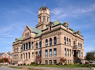
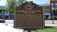
Fayette County is a county located in the U.S. state of Ohio. As of the 2020 census, the population was 28,951. Its county seat and largest city is Washington Court House. The county was named for the Marquis de Lafayette, a Frenchman who was an officer in the American Army in the Revolution, when established on March 1, 1810.

<span class="mw-page-title-main">Auglaize County, Ohio</span> County in Ohio, United States

Auglaize County is a county in Northwestern Ohio, United States of America. As of the 2020 census, the population was 46,442. Its county seat and largest city is Wapakoneta.

<span class="mw-page-title-main">Bourbon County, Kentucky</span> County in Kentucky, United States

Bourbon County is a county located in the U.S. state of Kentucky. As of the 2020 census, the population was 20,252. Its county seat is Paris. Bourbon County is part of the Lexington-Fayette, KY Metropolitan Statistical Area. It is one of Kentucky's nine original counties, and is best known for its historical association with bourbon whiskey.

<span class="mw-page-title-main">Allamakee County, Iowa</span> County in Iowa, United States

Allamakee County is the northeasternmost county in the U.S. state of Iowa. As of the 2020 census, the population was 14,061. Its county seat is Waukon.

<span class="mw-page-title-main">Fayette County, Indiana</span> County in Indiana, United States

Fayette County is one of 92 counties in U.S. state of Indiana located in the east central portion of the state. As of 2020, the population was 23,398. Most of the county is rural; land use is farms, pasture and unincorporated woodland. The county seat and only incorporated town is Connersville, which holds a majority of the county's population.

<span class="mw-page-title-main">Fayette County, Georgia</span> County in Georgia, United States

Fayette County is a county located in the north central portion of the U.S. state of Georgia. As of the 2020 census, the population was 119,194, an increase from 106,567 in 2010. Fayette County was established in 1821. The county seat, Fayetteville, was established in 1823. Much of Fayette County is bordered on the east side by the Flint River.

<span class="mw-page-title-main">LaFayette, Alabama</span> City in Alabama, United States

LaFayette is the county seat of Chambers County, Alabama, United States, 47 miles (76 km) northwest of Columbus, Georgia. As of the 2010 census, the population of the city was 3,003.

<span class="mw-page-title-main">Lawrenceburg, Indiana</span> City in Indiana, United States

Lawrenceburg is a city and the county seat of Dearborn County, Indiana, United States. The population was 5,129 at the 2020 census. It is the largest city in Dearborn County. Lawrenceburg is in southeast Indiana, on the Ohio River west of Cincinnati.

<span class="mw-page-title-main">Fayette, Missouri</span> City in Missouri, United States

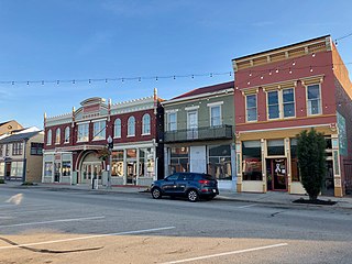
Fayette is a city in and the county seat of Howard County, Missouri, United States. It is part of the Columbia, Missouri Metropolitan Statistical Area. The city's population was 2,803 at the 2020 census.

<span class="mw-page-title-main">Sabina, Ohio</span> Village in Ohio, United States

Sabina is a village in Clinton County, Ohio, United States. As of the 2020 census, the village had a total population of 2,499.

<span class="mw-page-title-main">Canfield, Ohio</span> City in Ohio, United States

Canfield is a city in central Mahoning County, Ohio, United States. The population was 7,699 as of the 2020 census. A suburb about 8 miles (13 km) southwest of Youngstown, the city lies at the intersection of U.S. Routes 62 and 224 and is part of the Youngstown–Warren metropolitan area. In 2005, Canfield was rated the 82nd best place to live in the United States by Money magazine.

<span class="mw-page-title-main">McConnelsville, Ohio</span> Village in Ohio, United States

McConnelsville is a village in and the county seat of Morgan County, Ohio, United States, on the east bank of the Muskingum River. Located 21 miles (34 km) southeast of Zanesville and 26 miles (42 km) northwest of Marietta, the population was 1,667 at the 2020 census.

<span class="mw-page-title-main">Jefferson Township, Fayette County, Pennsylvania</span> Township in Pennsylvania, United States

Jefferson Township is a township in Fayette County, Pennsylvania, United States. The population was 2,007 at the 2020 census, a decline from the figure of 2,008 tabulated in 2010. It is named for former president Thomas Jefferson, and many of the township's streets are named after other U.S. presidents. Frazier School District serves the area.

<span class="mw-page-title-main">Springhill Township, Fayette County, Pennsylvania</span> Township in Pennsylvania, United States

Springhill Township is a township in Fayette County, Pennsylvania, United States. The population was 2,726 at the 2020 census. The Albert Gallatin Area School District serves the region.

<span class="mw-page-title-main">Newton, Texas</span> City in Texas, United States

Newton is a city in and the county seat of Newton County, Texas, United States. The population was 1,633 at the 2020 census.

<span class="mw-page-title-main">Louisa, Virginia</span> Town in Virginia, United States

Louisa is a town in Louisa County, Virginia, United States. The population was 1,555 at the 2010 census. It is the county seat of Louisa County.

<span class="mw-page-title-main">New Holland, Ohio</span> Village in Ohio, United States

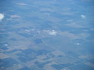
New Holland is a village in Fayette and Pickaway counties in Ohio, United States. The population was 804 at the 2020 census.

References

  1. 1 2 3 U.S. Geological Survey Geographic Names Information System: Washington Court House, Ohio
  2. "ArcGIS REST Services Directory". United States Census Bureau. Retrieved September 20, 2022.
  3. 1 2 3 "U.S. Census website". United States Census Bureau . Retrieved January 31, 2008.
  4. https://www.census.gov/quickfacts/fact/table/washingtoncourthousecityohio/PST045219 [ dead link ]
  5. 1 2 3 "Local History & Profile". cityofwch.com. Retrieved April 4, 2020.
  6. 1 2 3 "City Explains Its Reason in Deciding Name". The Advocate . Newark, Ohio. AP. September 5, 1931. p. 12. Retrieved April 4, 2020 via newspapers.com.
  7. "Charter | City of Washington Court House". 2008. pp. 2, 25. Retrieved April 4, 2020. Effective Date of Charter shall be January 1, 2004
  8. Suneson, Grant (November 6, 2017). "The Longest City Name in Every State". 247wallst.com. Retrieved April 4, 2020.
  9. 1 2 Allen, Frank M., ed. History of Fayette County, Ohio: Her People, Industries, and Institutions. Indianapolis: Bowen, 1914, 752.
  10. Dills, R.S. History of Fayette County, Together With Historic Notes on the Northwest, and the State of Ohio. Dayton: Odell and Mayer, 1881, 459.
  11. 1 2 "National Register Information System". National Register of Historic Places . National Park Service. July 9, 2010.
  12. Kilbourn, John (1833). The Ohio Gazetteer, or, a Topographical Dictionary. Scott and Wright. p.  479 . Retrieved December 12, 2013.
  13. Fayette County Comprehensive Use Strategy Plan Archived 2010-06-13 at the Wayback Machine , Fayette County, 2006, 13. Accessed 2013-05-23.
  14. "Col. Coit Acquitted". St. Joseph News-Press . St. Joseph, Missouri. March 9, 1895. p. 1. Retrieved April 4, 2020 via newspapers.com.
  15. "Bullet Holes in a Courthouse Door". Travel 88. December 5, 2017. Retrieved April 4, 2020.
  16. "US Gazetteer files 2010". United States Census Bureau . Retrieved January 6, 2013.
  17. "U.S. Climate Normals Quick Access – Station: Washington Court House, OH". National Oceanic and Atmospheric Administration. Retrieved March 4, 2023.
  18. "NOAA Online Weather Data – NWS Cincinnati". National Weather Service. Retrieved March 4, 2023.
  19. "Number of Inhabitants: Ohio" (PDF). 18th Census of the United States. U.S. Census Bureau. 1960. Retrieved May 17, 2020.
  20. "Ohio: Population and Housing Unit Counts" (PDF). U.S. Census Bureau. Retrieved May 17, 2020.
  21. "Washington Court House city, Ohio". census.gov. Retrieved July 7, 2022.
  22. "U.S. Census website". United States Census Bureau . Retrieved January 6, 2013.
  23. "Columbus Media Market Map". Echo Star. Retrieved January 6, 2014.
  24. "About Washington C.H. Record-Herald". Chronicling America. Library of Congress . Retrieved January 6, 2014.
  25. "About Washington Herald 1858-1860". Chronicling America. Library of Congress . Retrieved January 6, 2014.
  26. Self-reported, sworn statement of circulation (October 1, 2012). "Record Herald Rate Card" (PDF). Archived from the original (PDF) on October 8, 2013.{{cite web}}: |author= has generic name (help)
  27. "Homepage". Carnegie Public Library of Washington Court House. Retrieved February 25, 2018.