Melanesia is a subregion of Oceania in the southwestern Pacific Ocean. It extends from New Guinea in the west to the Fiji Islands in the east, and includes the Arafura Sea.

New Britain is the largest island in the Bismarck Archipelago, part of the Islands Region of Papua New Guinea. It is separated from New Guinea by a northwest corner of the Solomon Sea and from New Ireland by St. George's Channel. The main towns of New Britain are Rabaul/Kokopo and Kimbe. The island is roughly the size of Taiwan. While the island was part of German New Guinea, it was named Neupommern . In common with most of the Bismarcks it was largely formed by volcanic processes, and has active volcanoes including Ulawun, Langila, the Garbuna Group, the Sulu Range, and the volcanoes Tavurvur and Vulcan of the Rabaul caldera. A major eruption of Tavurvur in 1994 destroyed the East New Britain provincial capital of Rabaul. Most of the town still lies under metres of ash, and the capital has been moved to nearby Kokopo.

Pacific Islanders, Pasifika, Pasefika, Pacificans or rarely Pacificers are the peoples of the Pacific Islands. As an ethnic/racial term, it is used to describe the original peoples—inhabitants and diasporas—of any of the three major subregions of Oceania.

Bougainville Island is the main island of the Autonomous Region of Bougainville, which is part of Papua New Guinea. It was previously the main landmass in the German Empire-associated North Solomons. Its land area is 9,300 km2 (3,600 sq mi). The population of the whole province, including nearby islets such as the Carterets, is approximately 300,000. The highest point is Mount Balbi, on the main island, at 2,715 m (8,907 ft). The much smaller Buka Island, c. 500 km2 (190 sq mi), lies to the north, across the 400–500 m (1,300–1,600 ft) wide Buka Strait. Even though the strait is narrow, there is no bridge across it, but there is a regular ferry service between the key settlements on either side. The main airport in the north is in the town of Buka.

The Papuan languages are the non-Austronesian languages spoken on the western Pacific island of New Guinea, as well as neighbouring islands in Indonesia, Solomon Islands, and East Timor by around 4 million people. It is a strictly geographical grouping, and does not imply a genetic relationship.

Maritime Southeast Asia comprises the countries of Brunei, Indonesia, Malaysia, the Philippines, Singapore, and East Timor.

The indigenous peoples of Western New Guinea in Indonesia and Papua New Guinea, commonly called Papuans, are Melanesians. There is genetic evidence for two major historical lineages in New Guinea and neighboring islands: a first wave from the Malay Archipelago perhaps 50,000 years ago when New Guinea and Australia were a single landmass called Sahul and, much later, a wave of Austronesian people from the north who introduced Austronesian languages and pigs about 3,500 years ago. They also left a small but significant genetic trace in many coastal Papuan peoples.

Melanesians are the predominant and indigenous inhabitants of Melanesia, in an area stretching from New Guinea to the Fiji Islands. Most speak one of the many languages of the Austronesian language family or one of the many unrelated families of Papuan languages. There are several creoles of the region, such as Tok Pisin, Hiri Motu, Solomon Islands Pijin, Bislama, and Papuan Malay.

Morobe Province is a province on the northern coast of Papua New Guinea. The provincial capital and largest city is Lae. The province covers 33,705 km2, with a population of 674,810, and since the division of Southern Highlands Province in May 2012 it is the most populous province. It includes the Huon Peninsula, the Markham River, and delta, and coastal territories along the Huon Gulf. The province has nine administrative districts. At least 101 languages are spoken, including Kâte and Yabem language. English and Tok Pisin are common languages in the urban areas, and in some areas pidgin forms of German are mixed with the native language.

Vitiaz Strait is a strait between New Britain and the Huon Peninsula, northern New Guinea.

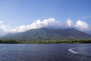
Karkar Island is an oval-shaped volcanic island located in the Bismarck Sea, about 30 kilometres off the north coast of mainland Papua New Guinea in Madang Province, from which it is separated by the Isumrud Strait. The island is about 25 km in length and 19 km in width. In the centre is an active volcano with two nested calderas.

The Eastern Trans-Fly languages are a small independent family of Papuan languages spoken in the Oriomo Plateau to the west of the Fly River in New Guinea.
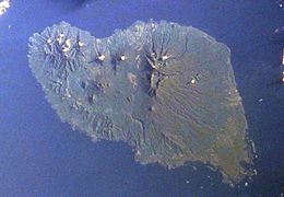
Long Island is a populated volcanic island in Madang Province, Papua New Guinea. It is located north of the island of New Guinea, separated from it by the Vitiaz Strait. The island's interior contains a 360m deep freshwater volcanic crater lake and within that lake exists an even smaller island known as Motmot island. During the late 17th or early 18th century virtually all of the biota on the island was destroyed and has subsequently provided scientists a unique opportunity to study recolonization efforts by plants, animals, and humans. The vast majority of the buildings on the island are constructed using vernacular architecture.
Numbami is an Austronesian language spoken by about 200 people with ties to a single village in Morobe Province, Papua New Guinea. It is spoken in Siboma village, Paiawa ward, Morobe Rural LLG.
Karnai ('Barim') is an Austronesian language spoken by about 915 individuals in small villages near Wasu, Morobe Province, on Umboi Island, and near Saidor in Madang Province, Papua New Guinea.

Papua New Guinea, a sovereign state in Oceania, is the most linguistically diverse country in the world. According to Ethnologue, there are 840 living languages spoken in the country. In 2006, Papua New Guinea Prime Minister Sir Michael Somare stated that "Papua New Guinea has 832 living languages ."

The Tami Islands are a small island group located 13 km SSE of Finschhafen in the Huon Gulf. It is part of today's Morobe Province, Papua New Guinea.
West Bird's Head languages are a small family of poorly documented Papuan languages spoken on the Bird's Head Peninsula of New Guinea.
Kovai is a Papuan language spoken on Umboi Island, halfway between mainland Papua New Guinea and the island of New Britain, and mostly within the caldera of that volcanic island.
On the morning of March 13, 1888, an explosion took place on Ritter Island, a small volcanic island in the Bismarck and Solomon Seas, between New Britain and Umboi Island. The explosion resulted in the collapse of most of the island and generated a tsunami with runups of up to 15 meters (49 ft) that caused damage more than 700 kilometers (430 mi) away and killed anywhere between 500 and 3,000 on neighbouring islands, including scientists and explorers. This event is the largest volcanic island sector collapse in recent history.